
跨学科方法论与地理信息公众化:质性GIS研究进展
作者贡献:Author Contributions
王源参与文献收集、整理和论文写作;赵振斌参与论文的修改。所有作者均阅读并同意最终稿件的提交。
WANG Yuan participated in literature collection and collation and thesis writing, and ZHAO Zhenbin participated in thesis revision. All authors read and approved the final manuscript for submission.
|
王 源(2000— ),女,内蒙古兴安盟人,硕士生,研究方向为质性GIS与社区旅游。E-mail: wyuann27@126.com |
收稿日期: 2024-11-11
修回日期: 2025-01-01
网络出版日期: 2025-01-23
基金资助
国家自然科学基金项目(42201245)
国家自然科学基金项目(41971227)
陕西省科技计划重点研发计划项目(2023-YBSF-029)
陕西省社会科学基金项目(2024J012)
Interdisciplinary Methodologies and the Civilianization of Geographic Information: Advances in Qualitative GIS Research
Received date: 2024-11-11
Revised date: 2025-01-01
Online published: 2025-01-23
Supported by
National Natural Science Foundation of China(42201245)
National Natural Science Foundation of China(41971227)
The Key Research and Development Project of Shaanxi Provincial Science and Technology Plan(2023-YBSF-029)
Social Science Foundation of Shaanxi Province, China(2024J012)
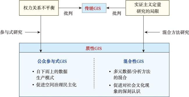
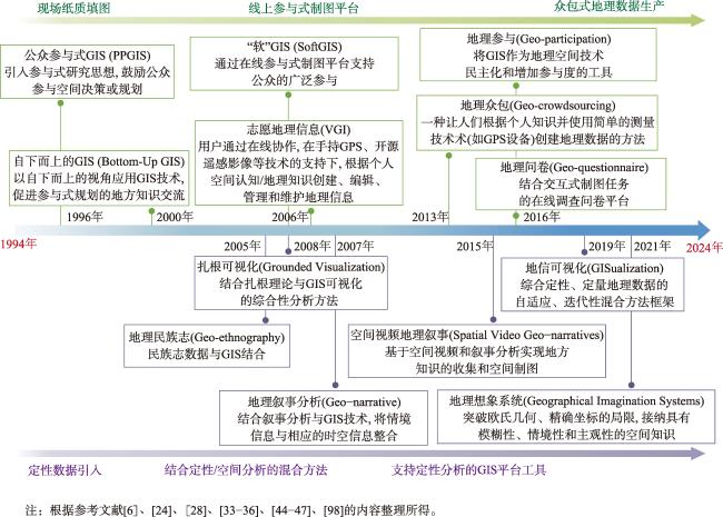
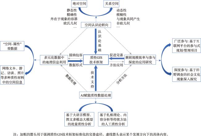
【意义】地理学的社会-文化转向及其与GIS技术的融合对于深入理解人地关系的复杂性具有重要意义。但在实践过程中,两者间往往存在着难以逾越的学科壁垒,如定性与定量、主观与客观的分歧等。对此,西方地理学界发展出一种能有效弥合上述学科矛盾的跨学科方法,即质性地理信息系统(质性GIS)。本文对质性GIS的研究进展进行梳理与总结,期望为国内地理学的社会文化研究提供新的方法启示,促进学科深入融合发展。【进展】质性GIS源于对传统地理信息技术的批判反思,引入了参与式研究和混合方法研究的方法论思想,一方面强调地理信息的公众化,鼓励公众参与地理信息的生产和使用;另一方面寻求方法论上的突破,发掘GIS处理定性信息的能力,推动在空间视角下形成对社会文化现象的深入理解。质性GIS在城乡空间规划、资源环境管理以及社会边缘群体赋权等领域具有广泛应用。【展望】结合质性GIS当前的发展现状和发展趋势,本文对质性GIS做出如下展望: ① 在空间认识论层面由“绝对空间”转向“关系空间”; ② 进一步提高对多种类型数据的包容性; ③ 发掘基于人工智能技术的定性数据批量处理能力; ④ 有机结合互联网技术和深度田野调查,实现规模效率和参与者能动性的权衡; ⑤ 推动质性GIS技术框架走向标准化。
王源 , 赵振斌 . 跨学科方法论与地理信息公众化:质性GIS研究进展[J]. 地球信息科学学报, 2025 , 27(1) : 100 -115 . DOI: 10.12082/dqxxkx.2025.240624
[Significance] The social-cultural transformation of geography and its integration with GIS technology are of great significance for gaining a deeper understanding of the complexity of human-land relationships. However, in practice, there are often insurmountable disciplinary barriers between the two fields, such as divergences between qualitative and quantitative methods and subjective versus objective perspectives. To address these challenges, the Western geography community has developed an interdisciplinary approach, known as qualitative GIS, that effectively bridges these disciplinary conflicts. This paper reviews and summarizes the research progress of qualitative GIS, aiming to provide new methodological insights for socio-cultural research in Chinese geographical studies and to promote deeper integration between the disciplines. [Progress] Qualitative GIS originates from a critical reflection on traditional geographic information technology and incorporates the methodological concepts of participatory research and mixed-methods research. On one hand, qualitative GIS emphasizes the democratization of geographic information, encouraging public participation in its production and use. On the other hand, it seeks methodological breakthroughs to enhance GIS's ability to process qualitative data, fostering a deeper understanding of phenomena from a spatial perspective. [Prospect] Based on the current development status and trends of qualitative GIS, this paper makes the following predictions for its future: (i) a shift from absolute space to relational space at the level of spatial epistemology; (ii) improved accommodation of diverse data types; (iii) exploration of the capacity for batch processing of qualitative data using AI technology; (iv) achieving a balance between research efficiency and participants' engagement through the integration of internet technology with in-depth fieldwork; and (v) the development of a standardized technological framework for qualitative GIS.
利益冲突:Conflicts of Interest 所有作者声明不存在利益冲突。
All authors disclose no relevant conflicts of interest.
① 指受地理、社会文化等复杂因素的影响而难以获得新鲜、营养食品的地区。
| [1] |
闾国年, 袁林旺, 陈旻, 等. 地理信息学科发展的思考[J]. 地球信息科学学报, 2024, 26(4):767-778.
[
|
| [2] |
王兴中. 社会地理学社会—文化转型的内涵与研究前沿方向[J]. 人文地理, 2004, 19(1):2-8.
[
|
| [3] |
关美宝, 谷志莲, 塔娜, 等. 定性GIS在时空间行为研究中的应用[J]. 地理科学进展, 2013, 32(9):1316-1331.
[
|
| [4] |
|
| [5] |
陈向明. 质的研究方法与社会科学研究[M]. 北京: 教育科学出版社, 2000.
[
|
| [6] |
|
| [7] |
|
| [8] |
|
| [9] |
冯健, 柴宏博. 定性地理信息系统在城市社会空间研究中的应用[J]. 地理科学进展, 2016, 35(12):1447-1458.
[
|
| [10] |
王韬, 刘云刚. 地图与制图术:国际批判制图学/GIS研究进展[J]. 地理科学进展, 2022, 41(6):1097-1108.
[
|
| [11] |
顾朝林, 于涛方, 李平, 等. 人文地理学流派[M]. 北京: 高等教育出版社, 2008.
[
|
| [12] |
|
| [13] |
|
| [14] |
|
| [15] |
|
| [16] |
|
| [17] |
|
| [18] |
|
| [19] |
|
| [20] |
张涵, 朱竑. 定性地理信息系统及其在人文地理学研究中的应用[J]. 世界地理研究, 2016, 25(1):125-136.
[
|
| [21] |
|
| [22] |
丹尼斯·伍德(Denis Wood)著王志弘等译. 地图的力量:使过去与未来现形[M]. 北京: 中国社会科学出版社, 2000.
[
|
| [23] |
马克·蒙莫尼尔(Mark Monmonier)著黄义军译. 会说谎的地图[M]. 北京: 商务印书馆, 2012.
[
|
| [24] |
|
| [25] |
|
| [26] |
|
| [27] |
|
| [28] |
|
| [29] |
|
| [30] |
|
| [31] |
|
| [32] |
|
| [33] |
|
| [34] |
|
| [35] |
|
| [36] |
|
| [37] |
|
| [38] |
|
| [39] |
|
| [40] |
|
| [41] |
关美宝. 超越地理学二元性:混合地理学的思考[J]. 地理科学进展, 2013, 32(9):1307-1315.
[
|
| [42] |
|
| [43] |
|
| [44] |
|
| [45] |
|
| [46] |
|
| [47] |
|
| [48] |
|
| [49] |
|
| [50] |
|
| [51] |
王丰龙, 陈倩敏, 许艳艳, 等. 沟通式规划理论的简介,批判与借鉴[J]. 国际城市规划, 2012, 27(6):82-90.
[
|
| [52] |
|
| [53] |
|
| [54] |
|
| [55] |
|
| [56] |
|
| [57] |
|
| [58] |
褚玉杰, 赵振斌, 张铖, 等. 旅游社区多群体态度差异和冲突倾向的空间特征——以西安汤峪镇为例[J]. 地理学报, 2016, 71(6):1045-1058.
[
|
| [59] |
陈诚, 赵振斌, 黄燕. 西部乡村旅游社区社会景观敏感度分析——以甘南郎木寺镇为例[J]. 地理研究, 2017, 36(5):899-912.
[
|
| [60] |
|
| [61] |
|
| [62] |
|
| [63] |
|
| [64] |
|
| [65] |
|
| [66] |
|
| [67] |
|
| [68] |
|
| [69] |
张予倩, 赵振斌, 李小永, 等. 城郊保护地 “三生” 空间变化对社会生态服务价值的影响——以邛海国家湿地公园为例[J]. 生态学报, 2023, 43(16):6772-6784.
[
|
| [70] |
黄燕, 赵振斌, 张铖, 等. 旅游社区价值空间构成与人群差异[J]. 旅游学刊, 2016, 31(9):80-90.
[
|
| [71] |
|
| [72] |
|
| [73] |
|
| [74] |
|
| [75] |
|
| [76] |
|
| [77] |
|
| [78] |
|
| [79] |
|
| [80] |
李卫江, 温家洪, 吴燕娟. 基于PGIS的社区洪涝灾害概率风险评估——以福建省泰宁县城区为例[J]. 地理研究, 2014, 33(1):31-42.
[
|
| [81] |
温家洪, 黄蕙, 陈珂, 等. 基于社区的台风灾害概率风险评估——以上海市杨浦区富禄里居委地区为例[J]. 地理科学, 2012, 32(3):348-355.
[
|
| [82] |
|
| [83] |
|
| [84] |
|
| [85] |
|
| [86] |
|
| [87] |
|
| [88] |
|
| [89] |
|
| [90] |
|
| [91] |
|
| [92] |
|
| [93] |
|
| [94] |
|
| [95] |
|
| [96] |
|
| [97] |
赵振斌, 褚玉杰, 郝亭, 等. 汉长安城遗址乡村社区意义空间构成[J]. 地理学报, 2015, 70(10):1606-1621.
[
|
| [98] |
|
/
| 〈 |
|
〉 |