
空间聚类模式发现研究进展:概念、方法及应用
作者贡献:Author Contributions
秦伟和杜世宏参与文献收集、内容构思;秦伟、张修远、白璐斌、杜世宏参与论文的写作和修改。所有作者均阅读并同意最终稿件的提交。
Literature collection and content conceptualization were contributed by QIN Wei and DU Shihong. The manuscript was drafted and revised by QIN Wei, ZHANG Xiuyuan, BAI Lubin, and DU Shihong. All the authors have read the last version of paper and consented for submission.
|
秦 伟(1994— ),男,江苏赣榆人,博士生,主要从事时空大数据挖掘研究。E-mail: qinwei@stu.pku.edu.cn |
收稿日期: 2024-12-14
修回日期: 2025-01-05
网络出版日期: 2025-01-23
基金资助
国家重点研发计划项目(2023YFC3804802)
Research Progress on Spatial Clustering Pattern Discovery: Concepts, Methods and Applications
Received date: 2024-12-14
Revised date: 2025-01-05
Online published: 2025-01-23
Supported by
National Key Research and Development Program of China(2023YFC3804802)
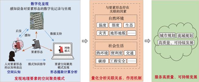
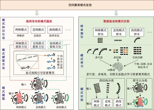
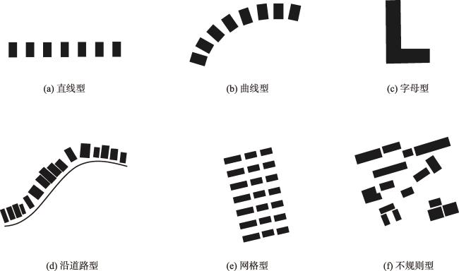
【意义】地理要素的空间聚类模式反映了要素的分布特征与空间格局,而模式发现对于揭示要素的空间分布规律、阐释地理现象的形成机制、理解人与空间的交互过程等具有重要意义。【进展】本文在阐述要素空间聚类模式内涵的基础上,梳理了空间聚类模式发现的两类方法,即规则导向的模式提取和数据驱动的模式识别。规则导向的模式提取方法根据专家知识对模式特点进行归纳,用形式化的显式规则表达并约束、指导模式发现过程;数据驱动的模式识别方法从“专家”和“数据”两方面汲取知识,在专家知识的指导下,通过大量样本自动化地从多尺度、多视角学习要素的模式特点。随后,具体针对建筑、道路和水系三类典型要素,系统归纳了三类要素模式的分类体系和空间聚类模式发现方法,尤其以图深度学习为代表的数据驱动方法由于其强大的模式学习能力,在模式发现精度上优于规则导向的模式提取方法。【展望】未来,要素空间聚类模式发现规则库和样本集的知识汇聚、聚类模式的主动发现技术、高效聚类模式发现的图深度学习模型以及基于生成式AI的模式发现等将成为主要研究方向。
秦伟 , 张修远 , 白璐斌 , 杜世宏 . 空间聚类模式发现研究进展:概念、方法及应用[J]. 地球信息科学学报, 2025 , 27(1) : 116 -130 . DOI: 10.12082/dqxxkx.2025.240683
[Significance] The spatial patterns of geographic features have a profound impact on the natural environment and human activities. Mining and discovering typical feature patterns from spatial-temporal data is a prerequisite for morphological analysis and planning, which can provide basic support for urban planning and watershed planning. Spatial clustering pattern is a significant and repeated orderly arrangement or combination of relationships between geographic features, which shows a significant distribution pattern and spatial morphology. The discovery of spatial clustering pattern of features is facilitated by spatial analysis, data mining, pattern recognition, and other related technical methods. This process helps to build a perception of the laws of the arrangement and combination of features within a complex and irregular collection of feature sets. Through analytical reasoning, it uncovers the spatial clustering and morphological structure of features with specific semantics. This discovery is of great significance in revealing the spatial distribution law of features, explaining the formation mechanism of geographic phenomena, and understanding the interaction process between humans and space. [Progress] On the basis of elaborating the connotation of spatial clustering patterns of features, this paper summarizes two types of methods for spatial clustering pattern discovery, including rule-oriented pattern extraction and data-driven pattern recognition. The rule-oriented pattern extraction methods rely on expert knowledge to summarize pattern characteristics. They express, constrain and guide the pattern discovery process with formal explicit rules, and extract the features of the specified spatial clustering patterns from the spatial data set. The data-driven pattern recognition methods draw knowledge from both 'experts' and 'data'. They learn the pattern characteristics of features from multiple scales and perspectives through a large number of samples automatically under the guidance of expert knowledge, and perform category prediction on a set of features in order to identify the spatial clustering patterns of the features. Subsequently, the spatial clustering pattern discovery of three types of typical features, namely buildings, roads and water systems, is reviewed. The data-driven approach represented by graph deep learning is usually superior to the rule-oriented pattern extraction approach in terms of pattern discovery accuracy due to its powerful pattern learning capability. In terms of the overall trend, spatial clustering pattern discovery of features is shifting from traditional methods to close integration with deep learning methods. [Prospect] In the future, knowledge aggregation of the rule base and sample set for feature spatial clustering pattern discovery, active discovery techniques for clustering patterns, graph deep learning models for efficient clustering pattern discovery, and pattern discovery based on generative AI will become the main research directions.
Key words: spatial clustering pattern; pattern discovery; building; road; water system; clustering; deep learning
表1 规则导向的模式提取与数据驱动的模式识别方法对比Tab. 1 Comparison between rule-oriented pattern extraction and data-driven pattern recognition methods |
| 方法 | 优势 | 不足 | 适用情景 |
|---|---|---|---|
| 规则导向的 模式提取方法 | 规则显式表达,提取过程易于理解、可解释性强。 | 规则依赖于专家知识,阈值难确定, 推广迁移难 | 小范围、简单模式 |
| 数据驱动的 模式识别方法 | 模式特征提取自动化,多尺度、多视角自学习, 精度相对较高,迁移能力强 | 模型发现过程、识别结果难解释,样本需求量大 | 大范围、复杂模式 |
利益冲突:Conflicts of Interest 所有作者声明不存在利益冲突。
All authors disclose no relevant conflicts of interest.
| [1] |
蔡智, 韩贵锋. 山地城市空间形态的地表热环境效应——基于LCZ的视角[J]. 山地学报, 2018, 36(4):617-627.
[
|
| [2] |
冷红, 赵妍, 袁青. 城市形态调控减碳路径与策略[J]. 城市规划学刊, 2023(1):54-61.
[
|
| [3] |
马童, 陈天. 城市滨河区空间形态对近地面通风影响机制及规划响应[J]. 城市发展研究, 2021, 28(7):37-42.
[
|
| [4] |
龙瀛, 叶宇. 人本尺度城市形态:测度、效应评估及规划设计响应[J]. 南方建筑, 2016(5):41-47.
[
|
| [5] |
阳丹. 城市空间形态与城市道路交通关系研究——以武汉市为例[D]. 武汉: 华中科技大学, 2006.
[
|
| [6] |
龙瀛, 唐婧娴. 城市街道空间品质大规模量化测度研究进展[J]. 城市规划, 2019, 43(6):107-114.
[
|
| [7] |
孟宪萌, 黄檬, 黄杰, 等. 流域地貌与河网结构影响机制及其演化模型的研究进展[J]. 地球科学进展, 2023, 38(8):780-789.
[
|
| [8] |
孟宪萌, 张鹏举, 周宏, 等. 水系结构分形特征的研究进展[J]. 地球科学进展, 2019, 34(1):48-56.
[
|
| [9] |
孙昭华. 水沙变异条件下河流系统调整机理及其功能维持初步研究[D]. 武汉: 武汉大学, 2004.
[
|
| [10] |
钟英铭. 基于深度学习的面向制图综合的建筑物群组模式识别研究[D]. 武汉: 华中师范大学, 2021.
[
|
| [11] |
崔晓杰. 城市道路网典型空间分布模式的识别方法研究[D]. 郑州: 战略支援部队信息工程大学, 2019.
[
|
| [12] |
晏雄锋. 深度卷积学习支持下的建筑物模式分析[D]. 武汉: 武汉大学, 2019.
[
|
| [13] |
王正阳. 线型分布建筑物群的识别和典型化方法研究[D]. 西安: 长安大学, 2023.
[
|
| [14] |
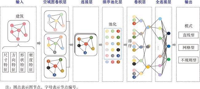
孟妮娜, 王安东, 周校东. 建筑物线型排列模式识别的图卷积神经网络方法[J]. 测绘科学技术学报, 2019, 36(6):627-631.
[
|
| [15] |
|
| [16] |
|
| [17] |
|
| [18] |
|
| [19] |
|
| [20] |
|
| [21] |
|
| [22] |
田晶, 何青松, 颜芬. 道路网stroke生成问题的形式化表达与新算法[J]. 武汉大学学报 (信息科学版), 2014, 39(5):556-560.
[
|
| [23] |
|
| [24] |
|
| [25] |
刘慧敏, 胡文柯, 唐建波, 等. 顾及功能语义特征的建筑物空间分布模式识别方法[J]. 测绘学报, 2020, 49(5):622-631.
[
|
| [26] |
邓敏, 孙前虎, 文小岳, 等. 建筑物层次空间聚类方法研究[J]. 计算机工程与应用, 2011, 47(28):120-123.
[
|
| [27] |
赵智尧. 建筑物矢量数据驱动的城市空间模式研究[D]. 武汉: 武汉大学, 2021.
[
|
| [28] |
|
| [29] |
|
| [30] |
王家耀, 武芳, 郭建忠, 等. 时空大数据面临的挑战与机遇[J]. 测绘科学, 2017, 42(7):1-7.
[
|
| [31] |
张新长, 华淑贞, 齐霁, 等. 新型智慧城市建设与展望:基于AI的大数据、大模型与大算力[J]. 地球信息科学学报, 2024, 26(4):779-789.
[
|
| [32] |
邓敏, 蔡建南, 杨文涛, 等. 多模态地理大数据时空分析方法[J]. 地球信息科学学报, 2020, 22(1):41-56.
[
|
| [33] |
|
| [34] |
|
| [35] |
|
| [36] |
张自强, 刘涛, 杜萍, 等. 典型建筑物群组模式的空间图卷积模型DGCNN识别方法[J]. 武汉大学学报 (信息科学版), 2024, 49(5):868-878.
[
|
| [37] |
|
| [38] |
|
| [39] |
|
| [40] |
|
| [41] |
艾廷华. 深度学习赋能地图制图的若干思考[J]. 测绘学报, 2021, 50(9):1170-1182.
[
|
| [42] |
谭敏, 林惠晶, 郝明. 先验知识引导深度学习的耕地范围建筑物和大棚房监测方法[J]. 地球信息科学学报, 2023, 25(11):2293-2302.
[
|
| [43] |
|
| [44] |
安晓亚, 朱余德, 晏雄锋. 卷积神经网络支持下的建筑物选取方法[J]. 测绘学报, 2023, 52(9):1574-1583.
[
|
| [45] |
令振飞. 图卷积神经网络支持下的建筑群组模式分类与相似检索[D]. 兰州: 兰州交通大学, 2023.
[
|
| [46] |
|
| [47] |
|
| [48] |
|
| [49] |
|
| [50] |
|
| [51] |
刘呈熠. 水系要素典型空间分布模式识别方法研究[D]. 郑州: 战略支援部队信息工程大学, 2022.
[
|
| [52] |
|
| [53] |
|
| [54] |
|
| [55] |
|
| [56] |
|
| [57] |
|
| [58] |
巩现勇. 城市建筑群典型空间分布模式的识别方法研究[D]. 郑州: 解放军信息工程大学, 2014.
[
|
| [59] |
|
| [60] |
|
| [61] |
巩现勇, 武芳, 钱海忠, 等. 建筑群多连通直线模式的参数识别方法[J]. 武汉大学学报 (信息科学版), 2014, 39(3):335-339.
[
|
| [62] |
|
| [63] |
于洋洋, 贺康杰, 武芳, 等. 面状居民地形状分类的图卷积神经网络方法[J]. 测绘学报, 2022, 51(11):2390-2402.
[
|
| [64] |
|
| [65] |
|
| [66] |
栾学晨. 保持结构模式的道路网数据多尺度建模[D]. 武汉: 武汉大学, 2013.
[
|
| [67] |
邹德慈. 路网、交通与城市规划[J]. 城市交通, 2011, 9(1):14-19.
[
|
| [68] |
曹炜威, 张红, 沈富强, 等. 不同模式道路网交通便捷性比较[J]. 地理信息世界, 2016, 23(4):25-30.
[
|
| [69] |
|
| [70] |
|
| [71] |
|
| [72] |
|
| [73] |
王米琪. 基于图卷积神经网络的道路网模式识别[D]. 武汉: 武汉大学, 2021.
[
|
| [74] |
|
| [75] |
|
| [76] |
|
| [77] |
|
| [78] |
|
| [79] |
|
| [80] |
田晶, 宋子寒, 艾廷华. 运用图论进行道路网网格模式提取[J]. 武汉大学学报 (信息科学版), 2012, 37(6):724-727.
[
|
| [81] |
|
| [82] |
杨必胜, 栾学晨. 城市道路网几何结构模式的自动识别方法[J]. 中国图象图形学报, 2009, 14(7):1251-1255.
[
|
| [83] |
|
| [84] |
田晶, 张泊宇, 吴荡. 一种矢量道路网辐射模式识别新方法[J]. 武汉大学学报 (信息科学版), 2013, 38(10):1234-1238.
[
|
| [85] |
何海威, 钱海忠, 谢丽敏, 等. 立交桥识别的CNN卷积神经网络法[J]. 测绘学报, 2018, 47(3):385-395.
[
|
| [86] |
|
| [87] |
|
| [88] |
|
| [89] |
|
| [90] |
|
| [91] |
|
| [92] |
|
| [93] |
|
| [94] |
王米琪, 艾廷华, 晏雄锋, 等. 图卷积网络模型识别道路正交网格模式[J]. 武汉大学学报 (信息科学版), 2020, 45(12):1960-1969.
[
|
| [95] |
杨滔, 林旭辉, 逯百慧. 人工演进的生成式城市空间形态研究[J]. 北京规划建设, 2024(4):45-49.
[
|
/
| 〈 |
|
〉 |
