
利用形变时序分形特征识别高山冰川区滑坡
作者贡献:Author Contributions
房颖晖、杨文涛、李郎平参与实验设计;房颖晖、田静、高佳鑫完成实验操作;房颖晖、李郎平、杨文涛参与论文写作和修改。所有作者均阅读并同意最终稿件提交。
The study was designed by FANG Yinghui, YANG Wentao and LI Langping. The experimental operation was completed by FANG Yinghui, TIAN Jing and GAO Jiaxin. The manuscript was drafted and revised by FANG Yinghui, LI Langping and YANG Wentao. All the authors have read the last version of paper and consented for submission.
|
房颖晖(2000— ),女,山东临沂人,硕士生,主要从事GIS、遥感与自然灾害的研究。E-mail: 476308786@qq.com |
收稿日期: 2024-08-09
修回日期: 2024-11-11
网络出版日期: 2025-01-23
基金资助
国家自然科学基金项目(42177150)
国家自然科学基金项目(41807500)
资源与环境信息系统国家重点实验室自主创新重点项目(KPI007)
Landslide Identification in Alpine Glacier Areas Using Fractal Features of Deformation Time Series
Received date: 2024-08-09
Revised date: 2024-11-11
Online published: 2025-01-23
Supported by
National Natural Science Foundation of China(42177150)
National Natural Science Foundation of China(41807500)
Key Project of Innovation LREIS(KPI007)
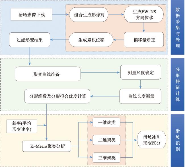
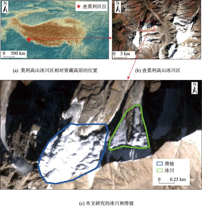
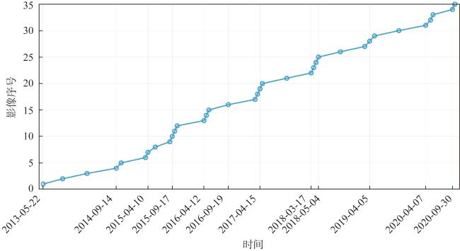
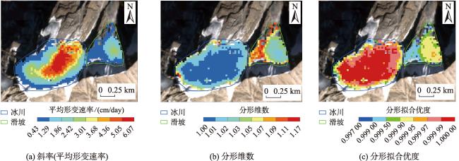
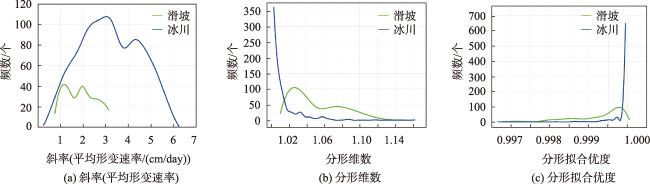
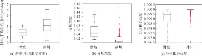
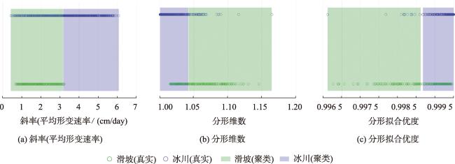
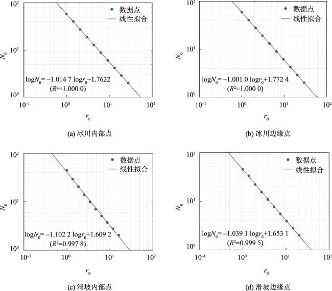
【目的】探究利用时序形变分形特征识别高山冰川区滑坡的方法并分析其适用性。【方法】基于查莫利滑坡及其相邻冰川的形变时间序列描述其斜率(平均形变速率)及分形特征差异,利用聚类分析区分滑坡区域与冰川并进行影响因素分析。【结果】与冰川相比,滑坡的形变时序具有较高的分形维数和较低的分形拟合优度。虽然滑坡与冰川在形变时序的斜率(平均形变速率)上也存在较大差异,但仅使用形变速率难以对滑坡进行聚类识别,准确率仅为61.70%;而使用形变时序的分形指标(包括分形维数和分形拟合优度)可将聚类分析的准确率显著提升至近84.00%。基于形变时序分形特征进行高山冰川区滑坡识别的适用性,根本原因在于滑坡和冰川在物质组成、影响因素和发展演化等方面存在差异。相较冰川,滑坡物质组成更复杂、更易受多种因素影响、形变时序的波动性更强。【结论】利用形变时序分形特征能够成功识别高山冰川区滑坡,在全球变暖背景下,该方法预期可为高山冰川区的滑坡识别、进而为高山冰川区的防灾减灾提供一定的支撑。
房颖晖 , 李郎平 , 杨文涛 , 兰恒星 , 田静 , 高佳鑫 . 利用形变时序分形特征识别高山冰川区滑坡[J]. 地球信息科学学报, 2025 , 27(1) : 239 -255 . DOI: 10.12082/dqxxkx.2025.240565
[Objectives] To investigate the use of temporal deformation fractal features for identifying landslides in alpine glaciated areas and analyze their applicability. [Methods] The deformation time series of the Chamoli landslide and its neighboring glacier were characterized using slope (average deformation rate) and fractal features (fractal dimension and fractal goodness of fit). Cluster analysis was used to distinguish landslide areas from glaciers and analyze influencing factors. [Results] The deformation time series of landslides exhibited higher fractal dimensions and lower fractal goodness of fit compared to glaciers. While significant differences in the slope of deformation time series (average deformation rate) were observed between landslides and glaciers, clustering analysis based solely on deformation rate achieved an accuracy of only 61.70%. In contrast, using fractal indexes of the deformation time series (fractal dimension and fractal goodness of fit) significantly improved clustering accuracy to nearly 84.00%. The applicability of this method is attributed to intrinsic differences in material composition, influencing factors, and developmental evolution between landslides and glaciers. Compared to glaciers, landslides are more complex in material composition, influenced by multiple factors, and exhibit greater variability in their deformation time series. [Conclusions] The study demonstrates the feasibility of identifying landslides in alpine glaciated areas using fractal features of deformation time series. In the context of global warming, this method has the potential to support landslide identification and contribute to disaster prevention and mitigation efforts in alpine glacier regions.
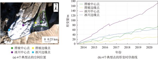
图4 查莫利滑坡及其相邻冰川形变时序的研究指标空间分布Fig. 4 Spatial distribution of research indicators for the deformation time series of Chamoli landslide and its adjacent glacier |
图5 查莫利滑坡及其相邻冰川形变时序的研究指标频数曲线Fig. 5 Frequency plots of research indicators for the deformation time series of Chamoli Landslide and its adjacent glacier |
图6 查莫利滑坡及其相邻冰川形变时序的研究指标箱线Fig. 6 Box plots of research indicators for the deformation time series of Chamoli Landslide and its adjacent glacier |
表1 查莫利滑坡及其相邻冰川形变时序几何指标Tab. 1 Statistics of geometric indices of the deformation time series of Chamoli Landslide and its adjacent glacier |
| 类别 | 最小值 | 最大值 | 范围 | 中位数 | 平均值 | 标准偏差 | 变异系数 | 峰度 | 偏度 | |
|---|---|---|---|---|---|---|---|---|---|---|
| 斜率(平均形变速率)/(cm/day) | 滑坡 | 0.676 | 3.231 | 2.555 | 1.892 | 1.900 | 0.681 | 0.359 | 1.913 | 0.167 |
| 冰川 | 0.427 | 6.066 | 5.639 | 3.134 | 3.194 | 1.316 | 0.412 | 2.098 | 0.057 | |
| 分形维数 | 滑坡 | 1.015 | 1.146 | 0.131 | 1.043 | 1.053 | 0.029 | 0.028 | 2.494 | 0.712 |
| 冰川 | 1.000 | 1.165 | 0.165 | 1.006 | 1.011 | 0.016 | 0.016 | 19.656 | 3.245 | |
| 分形拟合 优度 | 滑坡 | 0.997 | 1.000 | 0.003 | 0.999 | 0.999 | 0.001 | 0.001 | 4.115 | -1.271 |
| 冰川 | 0.997 | 1.000 | 0.003 | 1.000 | 1.000 | 0.000 | 0.000 | 64.610 | -6.303 |
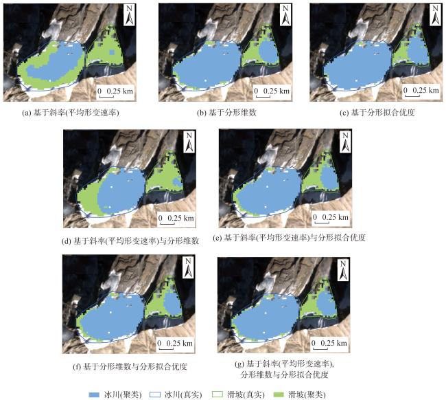
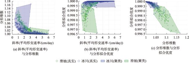
图9 基于时形变时序特征的二维聚类滑坡识别方案结果Fig. 9 Results of a two-dimensional clustering landslide identification scheme based on deformation time-series features |
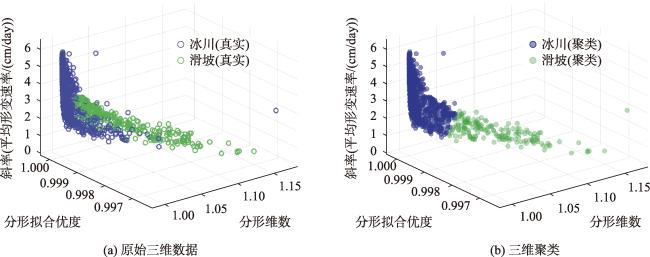
图10 基于时形变时序特征的三维聚类滑坡识别方案结果Fig. 10 Results of a three-dimensional clustering landslide identification scheme based on deformation time-series features |
表2 不同方案滑坡识别聚类准确率Tab. 2 Clustering accuracy value of landslide identification by different schemes (%) |
| 方案 | 聚类准确率 | 滑坡识别准确率 (真阳性率) | 滑坡识别错误率 (假阳性率) | |
|---|---|---|---|---|
| 一维 | 斜率(平均形变速率) | 61.70 | 98.85 | 50.64 |
| 分形维数 | 83.76 | 51.34 | 5.47 | |
| 分形拟合优度 | 82.52 | 34.87 | 1.65 | |
| 二维 | 斜率(平均形变速率)、分形维数 | 80.42 | 74.33 | 16.41 |
| 斜率(平均形变速率)、分形拟合优度 | 82.62 | 47.89 | 5.85 | |
| 分形维数、分形拟合优度 | 83.95 | 45.98 | 3.56 | |
| 三维 | 斜率(平均形变速率)、分形维数、分形拟合优度 | 82.90 | 50.19 | 6.23 |
利益冲突:Conflicts of Interest 所有作者声明不存在利益冲突。
All authors disclose no relevant conflicts of interest.
| [1] |
段克勤, 姚檀栋, 王宁练. 世纪亚洲高山区冰川平衡线高度变化及冰川演化趋势[J]. 中国科学:地球科学, 2022, 52(8):1603-1612.
[
|
| [2] |
刘易, 江利明, 张志敏, 等. 高亚洲冰川消融季遥感反照率与年际物质平衡相关性评估及分析[J]. 遥感学报, 2024, 28(6):1465-1479.
[
|
| [3] |
|
| [4] |
|
| [5] |
李涛, 李超, 沈翔, 等. 双站InSAR和ICESat-2测高相结合的西昆仑山近20年冰川物质平衡变化监测[J]. 测绘学报, 2023, 52(6):917-931.
[
|
| [6] |
|
| [7] |
|
| [8] |
|
| [9] |
|
| [10] |
|
| [11] |
|
| [12] |
|
| [13] |
|
| [14] |
|
| [15] |
|
| [16] |
|
| [17] |
|
| [18] |
|
| [19] |
魏欣, 申艳军, 宁奕冰, 等. 高山冰川区冰碛土形成过程、成土特征及滑坡灾变机制研究进展[J]. 工程地质学报, 2024, 32(3):947-962.
[
|
| [20] |
魏春蕊. 基于SAR与光学遥感数据的大量级形变监测技术研究[D]. 西安: 长安大学, 2023.
[
|
| [21] |
张勤, 赵超英, 陈雪蓉. 多源遥感地质灾害早期识别技术进展与发展趋势[J]. 测绘学报, 2022, 51(6):885-896.
[
|
| [22] |
|
| [23] |
|
| [24] |
|
| [25] |
焦洪赞, 尚成, 杨一峰, 等. 基于多重分形分析的城市职住空间结构演化研究——以武汉市为例[J]. 测绘地理信息, 2024,1-7.
[
|
| [26] |
张宇, 徐宗恒, 查玲珑, 等. 云南永胜古滑坡堰塞湖沉积物粒度多重分形特征及其指标适用研究[J]. 地理科学, 2024, 44(9):1666-1675.
[
|
| [27] |
冯永玖, 刘艳, 周茜, 等. 景观格局破碎化的粒度特征及其变异的分形定量研究[J]. 生态环境学报, 2013, 22(3):443-450.
[
|
| [28] |
|
| [29] |
郑文升, 杜南乔, 杨瑶, 等. 长江中游城市群空间结构的多分形特征[J]. 地理学报, 2022, 77(4):947-959.
[
|
| [30] |
侯亚丽, 匡文慧, 窦银银. 全球超大城市空间扩张及分形特征研究[J]. 地理学报, 2022, 77(11):2687-2702.
[
|
| [31] |
|
| [32] |
|
| [33] |
|
| [34] |
|
| [35] |
殷跃平, 李滨, 张田田, 等. 印度查莫利“2·7”冰岩山崩堵江溃决洪水灾害链研究[J]. 中国地质灾害与防治学报, 2021, 32(03):1-8.
[
|
| [36] |
|
| [37] |
|
| [38] |
|
| [39] |
李郎平, 兰恒星. 滑坡运动路径复杂度研究:综述与展望[J]. 地球科学, 2022, 47(12):4663-4680.
[
|
| [40] |
|
| [41] |
|
| [42] |
|
| [43] |
|
| [44] |
|
| [45] |
|
| [46] |
袁维, 孙瑞峰, 钟辉亚, 等. 阶跃型滑坡综合变形预测及监测预警方法研究[J]. 水利学报, 2023, 54(4): 461-473.
[
|
| [47] |
兰恒星, 张宁, 李郎平, 等. 川藏铁路可研阶段重大工程地质风险分析[J]. 工程地质学报, 2021, 29(2):326-341.
[
|
| [48] |
|
| [49] |
刘锦波, 张勇, 刘时银, 等. 青藏高原及周边石冰川识别、冰储量及动力学过程研究进展[J]. 地球科学进展, 2024, 39(4):391-404.
[
|
| [50] |
|
| [51] |
郭长宝, 闫怡秋, 张永双, 等. 青藏高原大型深层蠕滑型滑坡变形机制研究进展与展望[J]. 地球科学, 2022, 47(10):3677-3700.
[
|
| [52] |
邓李政, 袁宏永, 张鸣之, 等. 滑坡变形监测预警技术研究进展[J]. 清华大学学报(自然科学版), 2023, 63(6):849-864.
[
|
| [53] |
雷恒, 周晓岚, 王永强. 基于多重分形特征和分项组合预测联合响应的滑坡预警预测研究[J]. 大地测量与地球动学, 2022, 42(9):885-891.
[
|
| [54] |
|
| [55] |
|
| [56] |
许强, 陆会燕, 李为乐, 等. 滑坡隐患类型与对应识别方法[J]. 武汉大学学报(信息科学版), 2022, 47(3):377-387.
[
|
| [57] |
|
| [58] |
|
/
| 〈 |
|
〉 |