
从地理信息系统到地理智能体
作者贡献:Author Contributions
罗斌和刘文豪完成论文思路设计;韩嘉福,吴文周,李洪省,罗斌,刘文豪,吴进完成实验操作;刘文豪,罗斌,吴进参与论文的写作和修改。所有作者均阅读并同意最终稿件的提交。
LUO Bin and LIU Wenhao completed the design of the paper idea; HAN Jiafu, WU Wenzhou, LI Hongsheng, LUO Bin, LIU Wenhao, and WU Jin completed the experimental manipulation; LIU Wenhao, LUO Bin, and WU Jin participated in the writing and revision of the paper. All authors read and agreed to the submission of the final manuscript.
|
罗 斌(1982— ),男,湖南邵阳人,硕士,高级工程师,系统架构师,主要从事空间智能与认知地图、全息地球平台技术研究。E-mail: luob@igsnrr.ac.cn |
收稿日期: 2024-11-27
修回日期: 2025-01-09
网络出版日期: 2025-01-23
基金资助
国家重点研发计划项目(2021YFB3900901)
From Geographic Information System to Geographic Intelligent Agent
Received date: 2024-11-27
Revised date: 2025-01-09
Online published: 2025-01-23
Supported by
National Key Research and Development Program of China(2021YFB3900901)
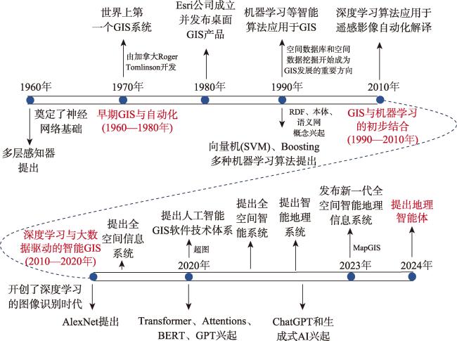
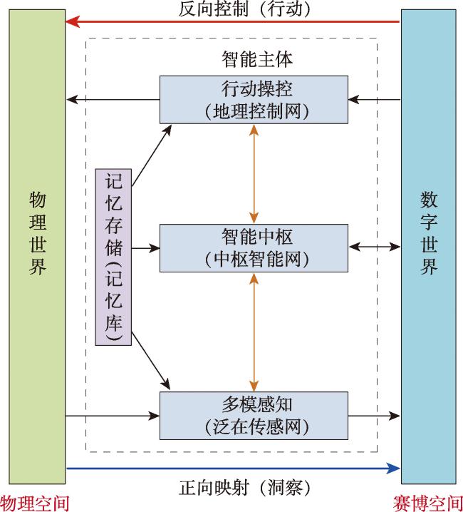
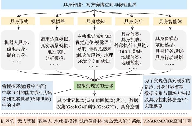
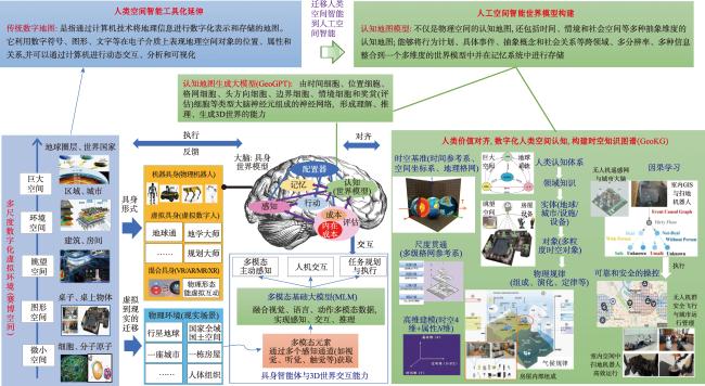
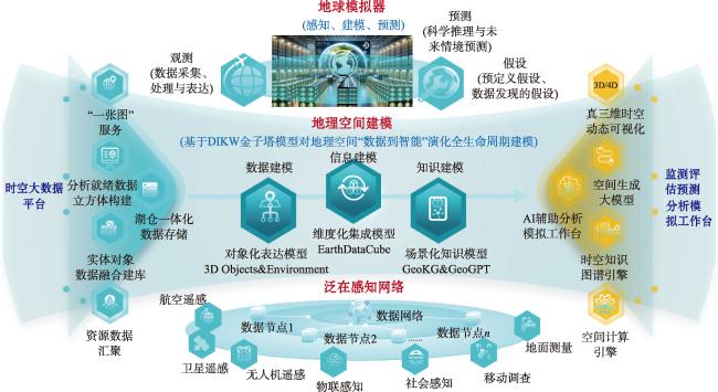
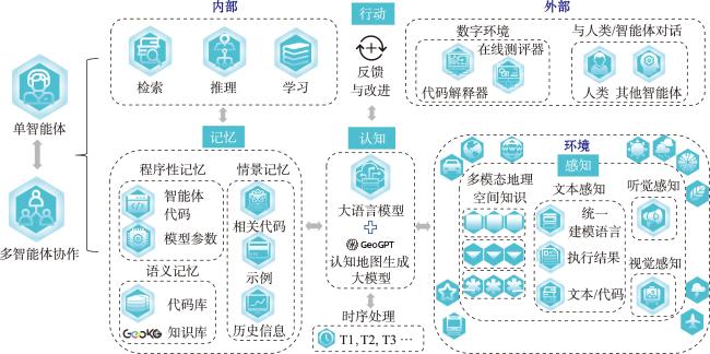
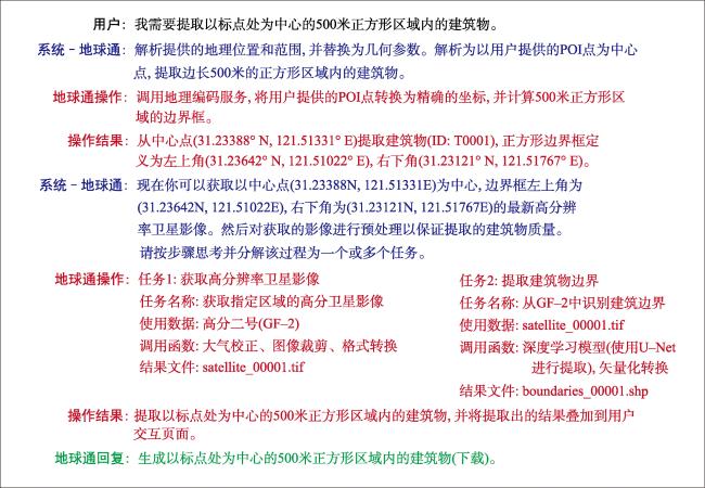
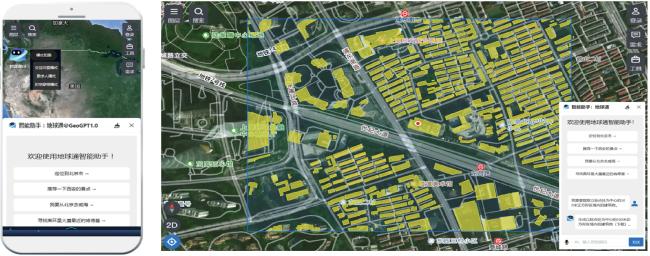
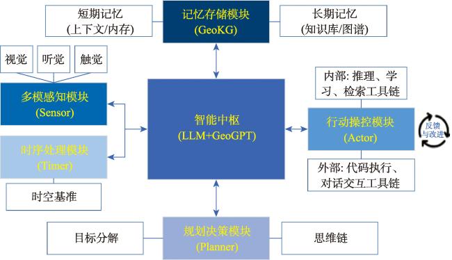
【目的】地理系统是涵盖地球表层自然与人文现象及其相互关系的综合系统,而现有地理信息系统(GIS)虽能数字化处理这些地理要素,但其局限性在于缺乏物理与信息空间的双向交互,并且其模型通常依赖于预设规则和历史数据,难以应对快速变化和三维结构复杂的地理情境。为此,本文提出了“地理智能体”,作为地理信息系统的进阶形式,融合了具身智能、自监督学习和多模态语言模型,旨在提升环境感知、空间理解和自主决策能力。【方法】本文设计的地理智能体架构包含多模态感知、智能中枢和行动操控模块,分别通过传感器网络获取全方位环境信息、利用知识图谱和生成模型进行复杂情境推理,并最终实现对物理环境的实时调控和多层次规划。此外,地理智能体将通过地球模拟器和试验场平台测试,以适应虚拟和真实环境的差异,从而在复杂、动态地理情境中具备更强的自主应对能力。【结果】本文以虚拟数字人“地球通”为例,初步展示地理智能体在空间智能化应用中的具体实现。【结论】“地球通”作为地理智能体的原型机,集成了时空知识图谱(GeoKG)和认知地图生成大模型(GeoGPT)等模块,能够辅助用户在应急管理、城市规划和生态监测等领域中快速获取智能化的空间决策支持,充分体现了地理信息系统从信息处理工具向自主空间智能体的发展演化。
罗斌 , 刘文豪 , 吴进 , 韩嘉福 , 吴文周 , 李洪省 . 从地理信息系统到地理智能体[J]. 地球信息科学学报, 2025 , 27(1) : 83 -99 . DOI: 10.12082/dqxxkx.2025.240658
[Objectives] The geographic system is an integrated framework encompassing natural and human phenomena and their interrelationships on the Earth's surface. While Geographic Information Systems (GIS) can digitally process these geographic elements, they face challenges in addressing rapidly changing geographic contexts with complex 3D structures. This is primarily due to the lack of bi-directional interactions between physical and informational spaces, as well as their reliance on predefined rules and historical data. In this paper, we propose the concept of a “Geographic Intelligent Agent” as an advanced form of GIS, which integrates embodied intelligence, self-supervised learning, and multimodal language modeling to improve environmental perception, spatial understanding, and autonomous decision-making. [Methods] The architecture of the geographic intelligent agent consists of three core components: multimodal perception, an intelligent hub, and an action manipulation module. These components collectively acquire comprehensive environmental information through sensor networks, perform complex situatio reasoning using knowledge graphs and generative models, and enable real-time control and multilevel planning of the physical environment. To adapt to differences between virtual and real environments, the geographic intelligent agent is tested using the earth simulator and a test field platform, equipping it with stronger autonomous capabilities in complex and dynamic geographic contexts. [Results] This paper also demonstrates the implementation of geographic intelligent agent in spatial intelligence applications using the virtual digital human “EarthSage” as an example. [Conclusion] As a prototype of the geographic intelligent agent, "EarthSage" integrates modules such as the spatiotemporal Knowledge Ggraph (GeoKG) and a Cognitive Map Generation Model (GeoGPT), assisting users in obtaining intelligent spatial decision-making support in fields such as emergency management, urban planning, and ecological monitoring. This work exemplifies the transformation of GIS from a traditional information processing tool to an autonomous spatial intelligent system, marking a significant advancement in the field.
利益冲突:Conflicts of Interest 所有作者声明不存在利益冲突。
All authors disclose no relevant conflicts of interest.
| [1] |
陈述彭. 地理系统与地理信息系统[J]. 地理学报, 1991, 46(1):1-7.
[
|
| [2] |
陈健飞, 连莲. 地理信息系统导论[M]. 北京: 科学出版社, 2003.
[
|
| [3] |
高松. 地理空间人工智能的近期研究总结与思考[J]. 武汉大学学报(信息科学版), 2020, 45(12):1865-1874.
[
|
| [4] |
张永生, 张振超, 童晓冲, 等. 地理空间智能研究进展和面临的若干挑战[J]. 测绘学报, 2021, 50(9):1137-1146.
[
|
| [5] |
苏奋振, 吴文周, 张宇, 等. 从地理信息系统到智能地理系统[J]. 地球信息科学学报, 2020, 22(1):2-10.
[
|
| [6] |
李德仁, 朱欣焰, 龚健雅. 从数字地图到空间信息网格——空间信息多级网格理论思考[J]. 武汉大学学报(信息科学版), 2003, 28(6):642-650.
[
|
| [7] |
|
| [8] |
|
| [9] |
|
| [10] |
周成虎. 全空间地理信息系统展望[J]. 地理科学进展, 2015, 34(2):129-131.
[
|
| [11] |
李德仁. 展望大数据时代的地球空间信息学[J]. 测绘学报, 2016, 45(4):379-384.
[
|
| [12] |
黎夏, 叶嘉安, 刘小平, 等. 地理模拟系统:元胞自动机与多智能体[M]. 北京: 科学出版社, 2007.
[
|
| [13] |
|
| [14] |
高俊, 曹雪峰. 空间认知推动地图学学科发展的新方向[J]. 测绘学报, 2021, 50(6):711-725.
[
|
| [15] |
|
| [16] |
|
| [17] |
|
| [18] |
|
| [19] |
|
| [20] |
|
| [21] |
|
| [22] |
|
| [23] |
|
| [24] |
何诗, 阴劼. 认知地图的地理学研究进展与展望[J]. 地理科学进展, 2022, 41(1): 73-85.
[
|
| [25] |
|
| [26] |
|
| [27] |
|
| [28] |
|
| [29] |
|
| [30] |
|
| [31] |
|
| [32] |
|
| [33] |
罗斌, 任丽秋, 毛悦, 等. 全息地球数据立方体模型研究[J]. 地球信息科学学报, 2023, 25(7):1282-1296.
[
|
| [34] |
黄勃, 吴申奥, 王文广, 等. 图模互补:知识图谱与大模型融合综述[J]. 武汉大学学报(理学版), 2024, 70(4):397-412.
[
|
| [35] |
|
| [36] |
|
/
| 〈 |
|
〉 |