
面向复杂自然场景的遥感地学分区智能解译框架及初探
作者贡献:Author Contributions
王志华主要参与第1、2、5、6节内容的撰写;张俊瑶、刘晓亮、李连发、董文、贺伟主要参与第3、4节内容的实验和写作;杨晓梅对整体进行了指导和修改。所有作者均阅读并同意最终稿件的提交。
Section 1, 2, 5, 6 were written by WANG Zhihua. Section 3, 4 and corresponding experiments were completed by ZHANG Junyao, LIU Xiaoliang, LI Lianfa, DONG Wen and HE Wei. And the manuscript was revised by YANG Xiaomei. All authors have read the last version of paper and consented for submission.
|
王志华(1988— ),男,河南信阳人,博士,副研究员,主要从事遥感大数据地学智能分析研究。E-mail: zhwang@lreis.ac.cn |
收稿日期: 2023-12-05
修回日期: 2024-01-31
网络出版日期: 2025-01-24
基金资助
国家重点研发计划项目(2021YFB3900501)
国家自然科学基金项目(42371473)
A Remote Sensing Intelligent Interpretation Framework Through Geo-Science Zoning for Complex Nature Scenes and Its Preliminary Experiments
Received date: 2023-12-05
Revised date: 2024-01-31
Online published: 2025-01-24
Supported by
National Key Research and Development Program of China(2021YFB3900501)
National Natural Science Foundation of China(42371473)
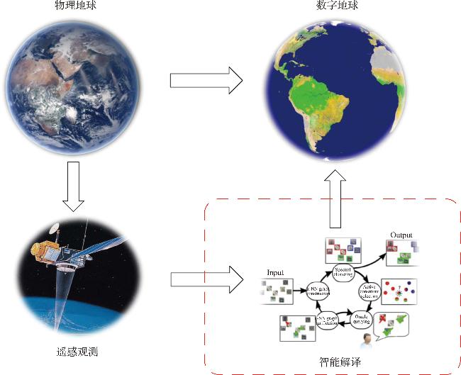
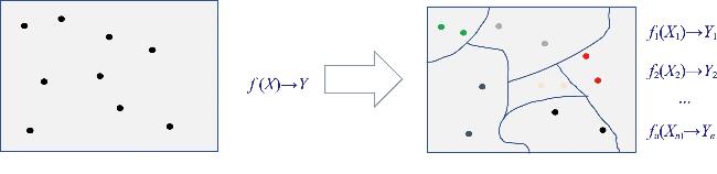
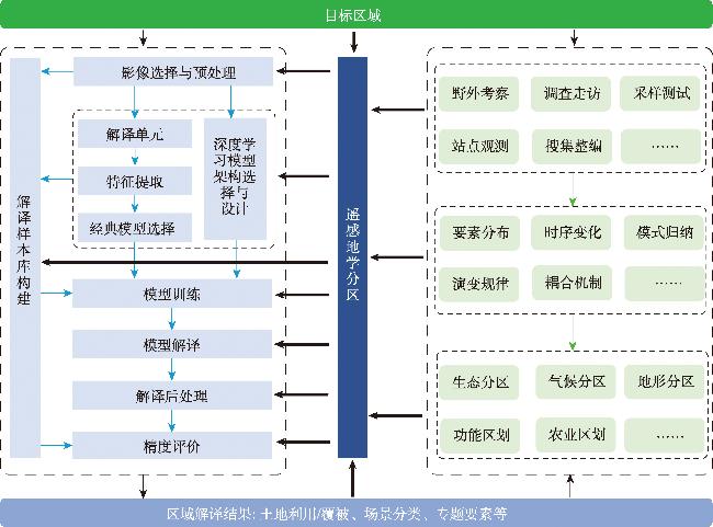
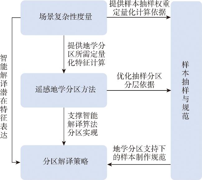
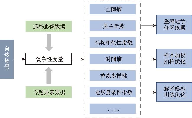
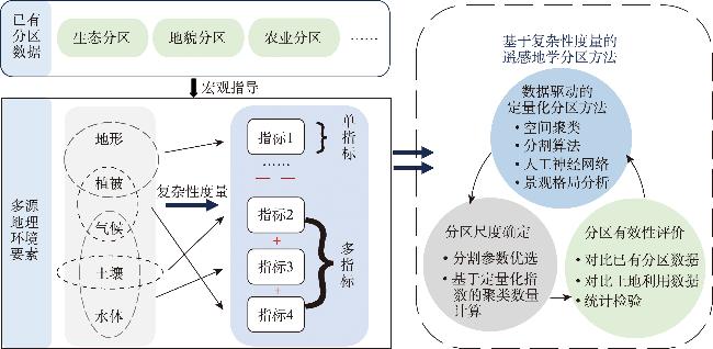
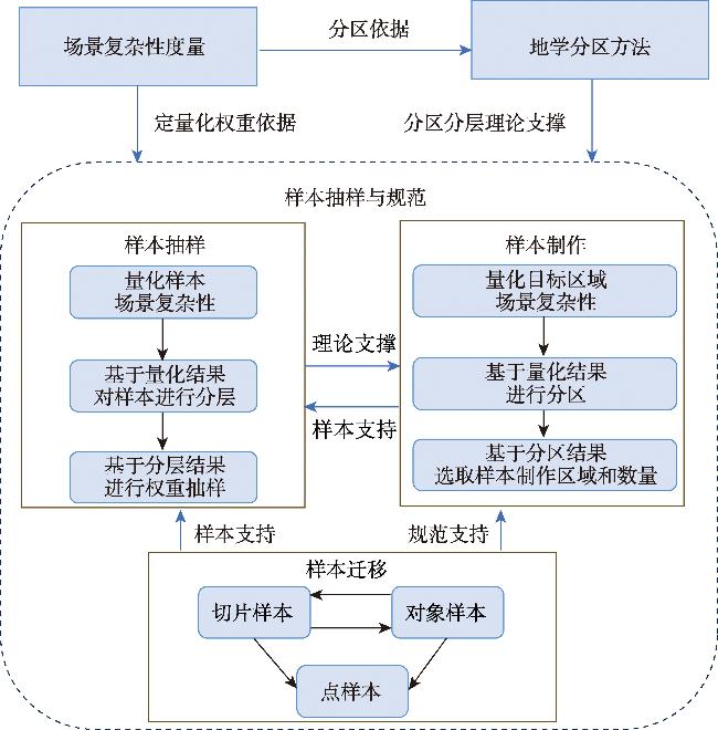
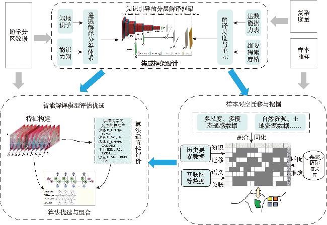
【目的】 当下,面向多圈层耦合、人类干扰强烈的复杂自然场景遥感智能解译在地学研究和实际业务中常存在不好用的问题。为此,本文从遥感地学认知原理角度出发,在明晰遥感智能解译的使命是依托遥感大数据更好地辅助建立数字地球之后,认为达成一致的知识表征模型是解决问题的关键,进而提出遥感解译与地学认知应该耦合为一个系统,以实现“数据获取知识”与“知识引导数据”的双向驱动。【分析】 在此基础上,提出以遥感地学分区为纽带的智能解译框架,以打通已有地学知识向遥感智能解译过程的输入与引导,增加解译结果与已有地学知识体系的匹配度。该框架主要依靠定量化的场景复杂性度量和地理分区知识耦合,形成面向遥感智能解译的地学分区方法以及分区样本抽样与规范,从而实现面向大区域的知识耦合下分区解译策略。【展望】 通过复杂度与优化抽样实验、影像分区分割尺度优选、耕地类型细分等实验,初步揭示了本框架思路在优选样本、影像分割、耕地精细类型识别等遥感智能解译多方面均存在巨大潜力。

王志华 , 杨晓梅 , 张俊瑶 , 刘晓亮 , 李连发 , 董文 , 贺伟 . 面向复杂自然场景的遥感地学分区智能解译框架及初探[J]. 地球信息科学学报, 2025 , 27(2) : 305 -330 . DOI: 10.12082/dqxxkx.2024.230729
[Objectives] Remote Sensing Intelligent Interpretation (RSII) often encounters challenges when applied for practical resource and environmental management, especially for complex scenes. To address this, we start from the explanation of why remote sensing interpretation is needed, and clarify that the mission of RSII is to achieve more rapid interpretation to build the digital twin earth with lower cost compared to manual interpretation. However, most RSII systems operate as a unidirectional process from remote sensing data to geoscience knowledge, lacking the feedback from knowledge to data. As a result, remote sensing information extracted from data often mismatch the knowledge of existing geoscience, creating a trust crisis between RSII researchers and geoscience researchers. And the crisis becomes more severe with the uncertainty of remote sensing information. [Analysis] We believe that an agreed upon representation model of geoscience knowledge between RSII researchers and geoscience researchers is necessary to alleviate the crisis. Based on this analysis, we propose a framework using geo-science zoning as the bridge to connect RSII researchers and geoscience researchers. In this framework, knowledge from geoscience could be transferred into the RSII system through geo-science zoning so that the interpretation results could be more coincided with geoscience knowledge. The framework mainly relies on (a) the scene complexity measurement, (b) the knowledge coupling of geographic regions to form the geological zoning method for remote sensing intelligent interpretation, and (c) the sampling specification of regional samples. The scene complexity measurement provides quantitative features for geoscience zoning and sampling weights assignment. Existing zoning data, such as ecological zoning data, geographic elements, and multisource remote sensing images are the main data inputs for geoscience zoning. The main principles for constructing zoning methods include (a) the geoscience elements type, (b) the scale of geoscience zoning, and (c) the process of information flow from data to knowledge. [Prospects] With these models, we can realize regional RSII guided by the knowledge. Preliminary experiments on complexity and optimization sampling, image segmentation scale optimization, cultivated land type fine classification, etc., reveal that this framework has great potential in improving the geoscience knowledge acquisition by RSII, enhancing the accuracy of the state-of-the-art RSII by 6%~10%, especially for the high-complexity nature scenes. However, the superiority of the framework may disappear if the scene for interpretation is simple, like the first level land use/cover classification, which is mainly caused by the inefficient samples after geoscience zoning. Therefore, more attention is needed in sampling when developing geoscience zoning framework.
表1 遥感智能解译研究现状与科学研究/业务需求的供需矛盾点Tab. 1 The contradictions between the providing state of remote sensing intelligent interpretation and the demands of geoscience research and management practice |
| 供需矛盾点 | 遥感智能解译总体现状 | 科学研究和业务需求 |
|---|---|---|
| 分类体系 | 以遥感影像视觉可区分的地物类型为主建立分类体系 | 以地理要素的社会、经济、生态等功能价值属性的异质性为主建立分类体系 |
| 解译结果表现形态 | 以遥感影像的像元为基本空间单元表达 | 以实际管理地块对应的图斑、科学研究中需要考虑的最小尺度图斑为基本空间单元 |
| 解译精度 | 小区域实验精度高,大区域应用精度低,且随主题、区域、情景不同而呈现强烈的空间分异性 | 大区域应用时精度高,且精度全区域标准化,能控制在一定的范围内 |
| 算法可控性 | 以深度学习为代表的智能解译算法,硬件需求越来越高,算法机理“黑箱化”,随着智能化的提升,可控性越来越弱 | 领域细分越来越明显,领域知识融入的可控性越来越高,对轻小型、低成本算法需求越来越旺 |
表2 数据集模型预测结果Tab. 2 Data set model prediction results |
| 地物类型 | 抽样方法 | 训练精度 | 测试精度 | |||||
|---|---|---|---|---|---|---|---|---|
| PA | JI | MIoU | PA | JI | MIoU | |||
| 建筑 | 随机抽样 | 0.85 | 0.75 | 0.74 | 0.85 | 0.75 | 0.74 | |
| 限制性优化+随机抽样 | 0.88 | 0.79 | 0.79 | 0.87 | 0.79 | 0.78 | ||
| 复杂度抽样 | 0.88 | 0.80 | 0.79 | 0.88 | 0.80 | 0.79 | ||
| 限制性优化+复杂度抽样 | 0.89 | 0.80 | 0.80 | 0.89 | 0.81 | 0.80 | ||
| 耕地 | 随机抽样 | 0.86 | 0.79 | 0.75 | 0.84 | 0.78 | 0.75 | |
| 限制性优化+随机抽样 | 0.87 | 0.80 | 0.80 | 0.85 | 0.79 | 0.76 | ||
| 复杂度抽样 | 0.94 | 0.90 | 0.88 | 0.86 | 0.87 | 0.85 | ||
| 限制性优化+复杂度抽样 | 0.95 | 0.91 | 0.91 | 0.86 | 0.89 | 0.87 | ||
| 林地 | 随机抽样 | 0.99 | 0.98 | 0.97 | 0.90 | 0.82 | 0.82 | |
| 限制性优化+随机抽样 | 0.99 | 0.98 | 0.98 | 0.91 | 0.83 | 0.83 | ||
| 复杂度抽样 | 0.99 | 0.98 | 0.98 | 0.90 | 0.81 | 0.81 | ||
| 限制性优化+复杂度抽样 | 0.99 | 0.99 | 0.99 | 0.92 | 0.84 | 0.83 | ||
| 草地 | 限制性优化+随机抽样 | 0.99 | 0.98 | 0.98 | 0.96 | 0.98 | 0.96 | |
| 随机抽样 | 1.00 | 0.99 | 0.99 | 0.97 | 0.99 | 0.98 | ||
| 限制性优化+复杂度抽样 | 1.00 | 0.99 | 0.99 | 0.97 | 0.99 | 0.97 | ||
| 复杂度抽样 | 1.00 | 0.99 | 0.99 | 0.97 | 0.99 | 0.98 | ||
| 水域 | 随机抽样 | 0.98 | 0.98 | 0.96 | 0.98 | 0.98 | 0.96 | |
| 限制性优化+随机抽样 | 0.99 | 0.99 | 0.97 | 0.99 | 0.99 | 0.97 | ||
| 复杂度抽样 | 1.00 | 1.00 | 0.99 | 0.99 | 1.00 | 0.99 | ||
| 限制性优化+复杂度抽样 | 1.00 | 1.00 | 0.99 | 0.99 | 1.00 | 0.99 | ||
表4 遥感地学分区方案分区依据分类Tab. 4 A system classification of Geo-Science Zoning solutions based on zoning basis |
| 分区依据 | 潜在效果 | |
|---|---|---|
| 研究对象所属的地理学要素类型或系统 | 生态:以森林、植被、水、裸地等生态要素为主 | 能够反映不同的地理要素或系统的多尺度分区差异性 |
| 生产:以农业、渔业、矿业等资源获取为主 | ||
| 生活:城市、乡村里的居住区、工业区、商业区等 | ||
| 研究对象的空间尺度 | 宏观尺度:分辨率公里以上的大气候、大地形地貌等地理规律空间分异性 | 够能反映研究对象分布模式在不同尺度上的差异性 |
| 中观尺度:分辨率30 m左右以土地利用/覆被分布模式 | ||
| 微观尺度:米级分辨率空间场景分布模式 | ||
| 数据到知识的信息 获取流程 | 数据:以遥感大数据为主的观测数据 | 能够根据可获取信息所处的不同流程环节针对性分区 |
| 信息:经过数学等手段加工为地理要素产品 | ||
| 知识:经地理学专家系统认知后的分区或者区划知识 | ||
表5 遥感地学分区方案依赖数据分类Tab. 5 A system classification of Geo-Science Zoning solutions based on depending data |
| 依赖数据 | 实现路径 |
|---|---|
| 已有地学分区或区划,例如生态分区、农业区划等 | 已有分区数据直接空间叠置融合 |
| 研究目标时空分布数据集,例如土地利用/覆被、专题要素等,以及其他 地理学环境要素产品,例如DEM、气温、降水、NDVI等 | 基于地理要素的复杂性度量-区域分布模式挖掘-区域划分 |
| 以时-空-谱多源遥感影像为主的观测数据 | 影像时空谱特征复杂性度量-区域分布模式挖掘-区域划分 |
| 观测数据、地理要素与地理区划等多源数据 | 空间叠置-复杂性度量-分布挖掘-综合区划 |
利益冲突: Conflicts of Interest 所有作者声明不存在利益冲突。
All authors disclose no relevant conflicts of interest.
| [1] |
《陈述彭编年纪事》编委会. 陈述彭编年纪事[M]. 北京: 科学出版社, 2021.
[ Editorial Committee of Chen Shupeng's Chronological Records. Chen Shupeng's Chronological Records[M]. Beijing: Science Press, 2021. ]
|
| [2] |
王志华, 杨晓梅, 周成虎. 面向遥感大数据的地学知识图谱构想[J]. 地球信息科学学报, 2021, 23(1):16-28.
[
|
| [3] |
杨晓梅, 王志华, 刘岳明, 等. 遥感智能信息处理的发展及技术前景[J]. 同济大学学报(自然科学版), 2023, 51(7):1025-1032.
[
|
| [4] |
吴田军, 骆剑承, 赵馨, 等. 精准地理应用驱动的高分遥感协同计算研究[J]. 武汉大学学报(信息科学版), 2022, 47(8):1220-1235.
[
|
| [5] |
王志华, 郜酷, 杨晓梅, 等. 地理学视角下土地利用/覆被分类发展探讨[J]. 地理研究, 2022, 41(11):2946-2962.
[
|
| [6] |
张兵, 杨晓梅, 高连如, 等. 遥感大数据智能解译的地理学认知模型与方法[J]. 测绘学报, 2022, 51(7):1398-1415.
[
|
| [7] |
王志华, 杨晓梅, 刘岳明, 等. 面向对象影像分析的地理学原理及分析框架启示[J]. 遥感学报, 2023:1-13.
[
|
| [8] |
钱学森, 于景元, 戴汝为. 一个科学新领域——开放的复杂巨系统及其方法论[J]. 自然杂志, 1990, 12(1):3-10,64.
[
|
| [9] |
骆剑承, 吴田军, 吴志峰, 等. 地理图斑智能计算及模式挖掘方法研究[J]. 地球信息科学学报, 2020, 22(1):57-75.
[
|
| [10] |
|
| [11] |
|
| [12] |
|
| [13] |
|
| [14] |
|
| [15] |
陈述彭, 赵英时. 遥感地学分析[M]. 北京: 测绘出版社, 1990.
[
|
| [16] |
周成虎, 骆剑承, 杨晓梅, 等. 遥感影像地学理解与分析[M]. 北京: 科学出版社, 1999.
[
|
| [17] |
杨存建, 周成虎. 基于知识的遥感图像分类方法的探讨[J]. 地理学与国土研究, 2001, 17(1):72-77.
[
|
| [18] |
周成虎, 骆剑承. 高分辨率卫星遥感影像地学计算[M]. 北京: 科学出版社, 2009.
[
|
| [19] |
|
| [20] |
|
| [21] |
|
| [22] |
|
| [23] |
朱阿兴, 闾国年, 周成虎, 等. 地理相似性:地理学的第三定律?[J]. 地球信息科学学报, 2020, 22(4):673-679.
[
|
| [24] |
刘南威, 郭有立, 张争胜. 综合自然地理学[M].3版. 北京: 科学出版社, 2009.
[
|
| [25] |
程维明, 周成虎, 李炳元, 等. 中国地貌区划理论与分区体系研究[J]. 地理学报, 2019, 74(5):839-856.
[
|
| [26] |
|
| [27] |
|
| [28] |
|
| [29] |
|
| [30] |
|
| [31] |
|
| [32] |
|
| [33] |
|
| [34] |
|
| [35] |
|
| [36] |
莫源富, 周立新. 分区分类法——针对山区遥感图象的一种有效的分类方法[J]. 中国岩溶, 2000, 19(4):360-365.
[
|
| [37] |
师庆东, 吕光辉, 潘晓玲, 等. 遥感影像中分区分类法及在新疆北部植被分类中的应用[J]. 干旱区地理, 2003, 26(3):264-268.
[
|
| [38] |
张翊涛, 陈洋, 王润生. 结合自动分区与分层分析的多光谱遥感图像地物分类方法[J]. 遥感技术与应用, 2005, 20(3):332-337.
[
|
| [39] |
李石华, 王金亮, 陈姚. 独龙江流域TM图像的分区分类方法探讨[J]. 遥感信息, 2006, 21(3):40-43,93.
[
|
| [40] |
申怀飞, 胡楠, 丁圣彦, 等. 基于主成分融合的遥感影像分区分类方法探讨[J]. 河南大学学报(自然科学版), 2007, 37(3):294-299.
[
|
| [41] |
竞霞, 王锦地, 王纪华, 等. 基于分区和多时相遥感数据的山区植被分类研究[J]. 遥感技术与应用, 2008, 23(4):394-397,360.
[
|
| [42] |
李文莉, 杨泽元, 李瑛, 等. 基于分区和纹理特征的伊犁河谷遥感影像土地利用分类[J]. 测绘与空间地理信息, 2013, 36(8):68-71.
[
|
| [43] |
于菲菲, 曾永年, 徐艳艳, 等. 基于植被分区的多特征遥感智能分类[J]. 国土资源遥感, 2014, 26(1):63-70.
[
|
| [44] |
周文, 明冬萍, 闫鹏飞. 结合影像分区与尺度估计的耕地提取方法研究[J]. 地球信息科学学报, 2018, 20(7):1014-1025.
[
|
| [45] |
刘巍, 吴志峰, 骆剑承, 等. 深度学习支持下的丘陵山区耕地高分辨率遥感信息分区分层提取方法[J]. 测绘学报, 2021, 50(1):105-116.
[
|
| [46] |
林双双. 地形信息支持下的山区耕地分区分层提取方法[D]. 贵阳: 贵州师范大学, 2023.
[
|
| [47] |
赵辰雨. 基于深度学习的农田场景分区智能解译研究[D]. 廊坊: 北华航天工业学院, 2023.
[
|
| [48] |
|
| [49] |
|
| [50] |
|
| [51] |
王雷, 汤国安, 刘学军, 等. DEM地形复杂度指数及提取方法研究[J]. 水土保持通报, 2004, 24(4):55-58.
[
|
| [52] |
|
| [53] |
|
| [54] |
|
| [55] |
|
| [56] |
|
| [57] |
|
| [58] |
|
| [59] |
|
| [60] |
|
| [61] |
|
| [62] |
|
| [63] |
|
| [64] |
|
| [65] |
|
| [66] |
陆尘, 杨晓梅, 王志华. 基于样本自动扩充的街区式农村居民地遥感提取方法[J]. 地球信息科学学报, 2018, 20(9):1306-1315.
[
|
| [67] |
饶杨莉, 张玉金, 周兴霞, 等. 面向深度学习的遥感影像样本库建设技术研究[J]. 测绘与空间地理信息, 2023, 46(4):38-42.
[
|
| [68] |
|
| [69] |
张定祥, 汪秀莲, 刘顺喜, 等. 第三次全国国土调查土地利用矢量数据栅格化方法[J]. 测绘通报, 2022, 0(4):138-144.
[
|
| [70] |
|
| [71] |
刘亚岚, 阎守邕, 王涛, 等. 遥感图像分区自动分类方法研究[J]. 遥感学报, 2002, 6(5):357-363.
[
|
| [72] |
|
| [73] |
|
| [74] |
|
| [75] |
秦其明. 遥感图像自动解译面临的问题与解决的途径[J]. 测绘科学, 2000, 25(2):21-24.
[
|
| [76] |
杜培军, 王欣, 蒙亚平, 等. 面向地理国情监测的变化检测与地表覆盖信息更新方法[J]. 地球信息科学学报, 2020, 22(4):857-866.
[
|
| [77] |
骆剑承, 胡晓东, 吴炜, 等. 地理时空大数据协同计算技术[J]. 地球信息科学学报, 2016, 18(5):590-598.
[
|
/
| 〈 |
|
〉 |
