
基于H3六边形格网的水文分析算法
作者贡献:Author Contributions
赵含旭和王磊参与实验设计;赵含旭、宋志学、章鹏飞完成实验操作;赵含旭、张子昕、殷楠完成实验数据处理;赵含旭、章鹏飞、张子昕、殷楠参与论文的写作和修改。所有作者均阅读并同意最终稿件的提交。
The study was designed by ZHAO Hanxu and WANG Lei. The experimental data processing was completed by ZHAO Hanxu, ZHANG Zixin, and YIN Nan. The experimental operation was completed by ZHAO Hanxu, SONG Zhixue, and ZHANG Pengfei. The manuscript was drafted and revised by ZHAO Hanxu, ZHANG Pengfei, ZHANG Zixin, and YIN Nan. All the authors have read the last version of paper and consented for submission.
|
赵含旭(2000— ),男,河南焦作人,硕士生,主要从事GIS算法研究。E-mail: zhx000121@163.com |
收稿日期: 2024-08-16
修回日期: 2024-12-17
网络出版日期: 2025-01-24
基金资助
国家自然科学基金项目(41801318)
河南省高等学校青年骨干教师培养计划(2023GGJS054)
河南理工大学青年骨干教师资助计划项目(2018XQG-03)
河南理工大学博士基金项目(B2017-14)
Hydrological Analysis Algorithm Based on H3 Hexagonal Grid
Received date: 2024-08-16
Revised date: 2024-12-17
Online published: 2025-01-24
Supported by
National Natural Science Foundation of China(41801318)
Training Program for Young Backbone Teachers in Colleges and Universities of Henan Province(2023GGJS054)
Henan Polytechnic University Young Backbone Teachers Funding Program Project(2018XQG-03)
Doctoral Fund Project of Henan Polytechnic University(B2017-14)
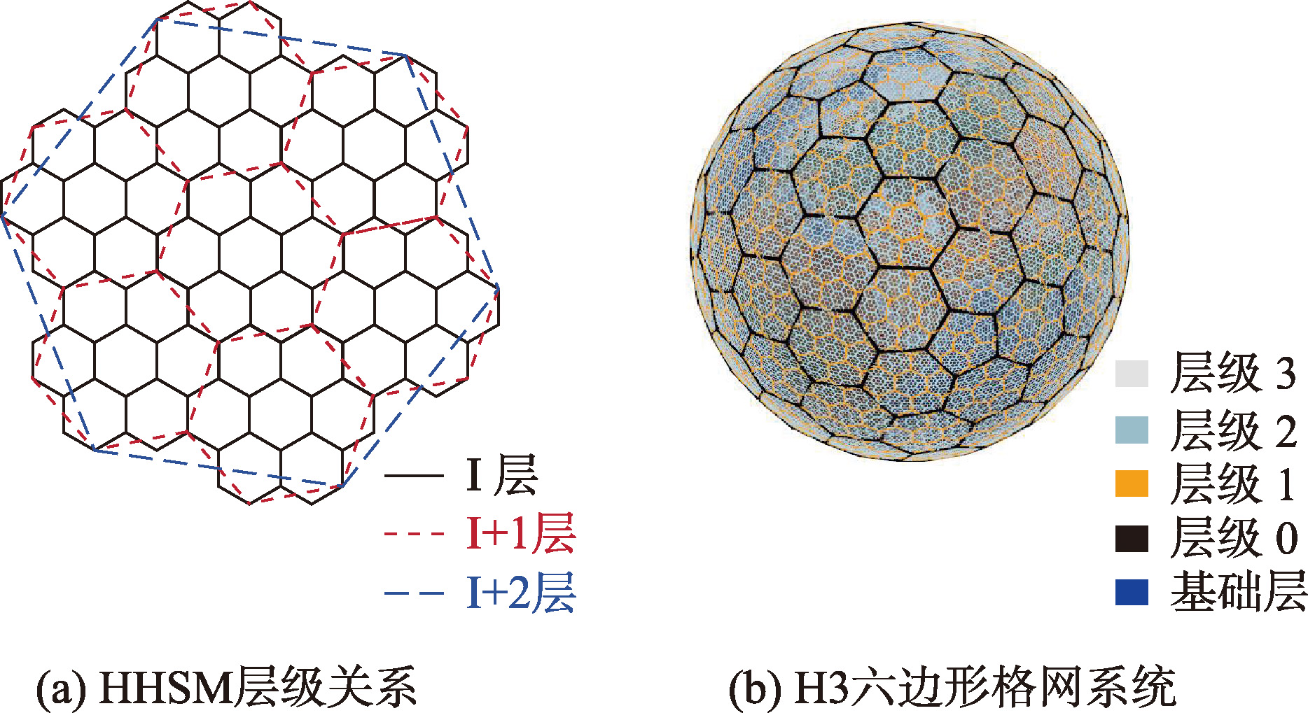
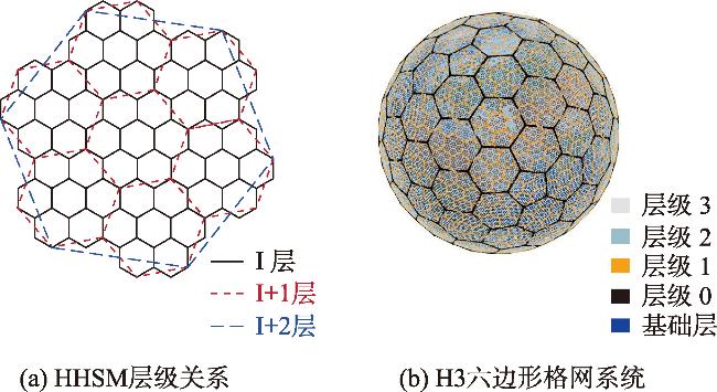
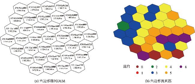
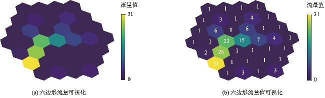
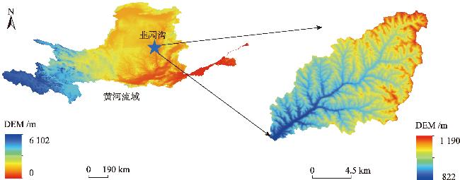
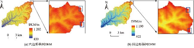
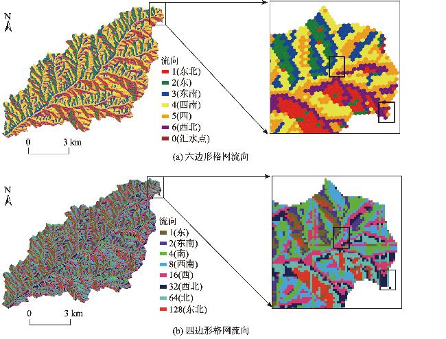
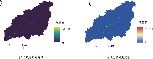
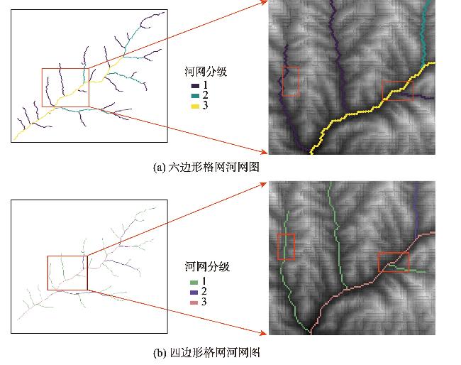
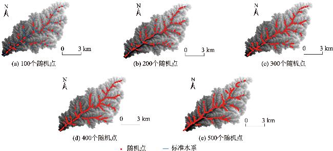
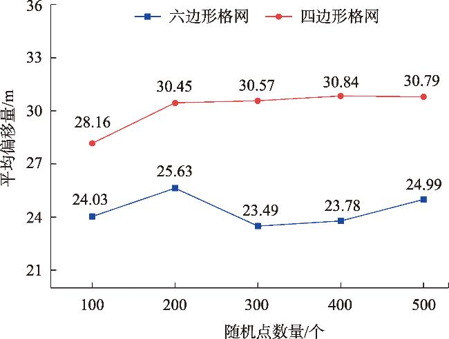
【目的】 流域水文信息提取对于水资源管理、洪水预警和生态保护至关重要。传统水文建模多采用四边形格网进行空间离散化,但由于其邻接性不统一、形状失真和拓扑结构表示不准确等问题,导致流域提取时容易在细节处出现阶梯状及平行河流线条,尤其在河流的弯曲和分叉点处更为明显。相比之下,六边形格网因其各向同性、较好的边界效果和均匀的空间分布等优势,能够更好地保持曲线和分叉点的形态,准确地模拟水文过程和提取流域。【方法】 本文基于H3六边形格网系统,以韭园沟流域为研究区,使用分辨率为30 m的SRTM 1数字高程模型(DEM),通过六边形格网生成、DEM重采样、填洼、流向分析、流量累积等步骤,设计了一套基于六边形格网的水文分析算法,并对流量累积和河网提取的数据质量进行评价与分析。首先,本文通过统计流量值1~15的六边形格网与四边形格网所占其格网总数的百分比,结果表明六边形格网在低流量值范围内表现更为集中,在流量值增加时保持更稳定的累积频数增长,避免在高流量值范围内出现过度集中的情况。此外,以更高分辨率(12.5 m)的韭园沟流域河网作为标准河网,将河流线段按长度比例随机选取100、200、300、400、500个点,计算其到最近的四边形格网和六边形格网的平均距离,得到2种方法提取河网的平均偏移量。【结果】 结果显示四边形格网的平均偏移量分别为28.16、30.45、30.57、30.84、30.79 m,六边形格网的平均偏移量为24.03、25.63、23.49、23.78 、24.99 m,六边形格网的平均偏移量均小于四边形格网,表明其具有更高的河网提取精度,能更好地反映地形特征。【结论】 综上,与传统四边形格网相比,六边形格网在流量累积、河网提取方面,展现出更高的空间一致性和精确性,为水文模拟和流域分析提供了一种更高效、更准确的解决方案。
赵含旭 , 王磊 , 宋志学 , 章鹏飞 , 张子昕 , 殷楠 . 基于H3六边形格网的水文分析算法[J]. 地球信息科学学报, 2025 , 27(2) : 479 -490 . DOI: 10.12082/dqxxkx.2025.240454
[Objectives] The extraction of watershed hydrological information is crucial for water resource management, flood forecasting, and ecological protection. Traditional hydrological modeling often employs quadrilateral grids for spatial discretization. However, due to issues such as inconsistent adjacency, shape distortion, and inaccurate representation of topological structures, watershed extraction often results in staircase-like and parallel river line features in finer details, especially at curved sections and bifurcation points of rivers. In contrast, hexagonal grids, with their isotropy, improved boundary effects, and uniform spatial distribution, are better at preserving the morphology of curves and bifurcation points. They thereby enable more accurate simulation of hydrological processes and watershed extraction. [Methods] This study adopts the H3 hexagonal grid system, using the Jiuyuangou watershed as the study area. A 30-meter resolution SRTM 1 Digital Elevation Model (DEM) was used to design a hydrological analysis algorithm based on hexagonal grids. The methodology includes hexagonal grid generation, DEM resampling, depression filling, flow direction analysis, and flow accumulation. The quality of flow accumulation and river network extraction was evaluated. Firstly, the study compared the percentage of hexagonal and quadrilateral grids contributing to total grids across flow values ranging from 1 to 15. Results showed that hexagonal grids demonstrated greater concentration in low flow values and maintained more stable cumulative frequency growth with increasing flow values, avoiding over-concentration in high flow value ranges. Additionally, a higher-resolution Jiuyuangou river network (12.5 m) was used as the standard river network. Points were randomly sampled in proportion to the river line segment length at intervals of 100, 200, 300, 400, and 500 points. The average distance to the nearest quadrilateral and hexagonal grids was then calculated. [Results] The results show that the average offsets for quadrilateral grids were 28.16 m, 30.45 m, 30.57 m, 30.84 m, and 30.79 m, respectively. For hexagonal grids, the average offsets were 24.03 m, 25.63 m, 23.49 m, 23.78 m, and 24.99 m, respectively. Hexagonal grids consistently exhibited smaller average offsets than quadrilateral grids, demonstrating higher precision in river network extraction and better reflection of terrain characteristics. [Conclusions] Compared to traditional quadrilateral grids, hexagonal grids exhibit superior spatial consistency and accuracy in flow accumulation and river network extraction. This provides a more efficient and precise solution for hydrological modeling and watershed analysis.
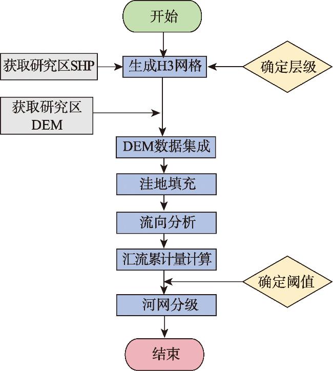
| 算法1 H3六边形格网洼地填充算法 |
|---|
| 1 输入:H3六边形格网数据 2 遍历所有H3索引,若length(h3.hex_ring (index, 1)) < 6,将 index加入队列 Q 3 在队列Q中找到高程值最低的格网,记为L 4 获取格网L的所有邻居, neighbors = h3.hex_ring (L, 1) 5 将 neighbors 中不在队列 Q 中的格网加入队列 A 6 遍历队列A中的格网,将高程值低于L的记为M 7 提升格网M的高程值,h3_data[M] = h3_data[L] + 0.01m 8 将队列A的所有格网加入队列Q 9 重复步骤3—步骤8,直至队列Q无需进一步处理 10 输出:更新后的H3六边形格网数据,完成填洼 |
表1 流量值1~15的六边形格网与四边形格网所占其格网总数的百分比Tab. 1 The percentage of hexagonal and quadrilateral grids with flow values 1-15 in the total number of their grids |
| 占比 | 流量值 | ||||||||||||||
|---|---|---|---|---|---|---|---|---|---|---|---|---|---|---|---|
| 1 | 2 | 3 | 4 | 5 | 6 | 7 | 8 | 9 | 10 | 11 | 12 | 13 | 14 | 15 | |
| 六边形格网/% | 25.96 | 21.29 | 11.12 | 5.46 | 3.12 | 2.27 | 1.33 | 1.09 | 0.99 | 0.75 | 0.53 | 0.52 | 0.47 | 0.39 | 0.37 |
| 四边形格网/% | 19.18 | 11.51 | 6.75 | 4.33 | 3.07 | 2.00 | 1.63 | 1.29 | 1.05 | 0.84 | 0.75 | 0.62 | 0.50 | 0.47 | 0.39 |
利益冲突: Conflicts of Interest 所有作者声明不存在利益冲突。
All authors disclose no relevant conflicts of interest.
| [1] |
刘昌明, 刘璇, 杨亚锋, 等. 水文地理研究发展若干问题商榷[J]. 地理学报, 2022, 77(1):3-15.
[
|
| [2] |
华一新, 赵鑫科, 张江水. 地理信息系统研究新范式[J]. 地球信息科学学报, 2023, 25(1):15-24.
[
|
| [3] |
汤国安. 我国数字高程模型与数字地形分析研究进展[J]. 地理学报, 2014, 69(9):1305-1325.
[
|
| [4] |
张宏鸣, 樊世豪, 陈茹雪, 等. 基于数字高程模型的淤地坝地区河网提取方法[J]. 农业机械学报, 2023, 54(9):246-253,269.
[
|
| [5] |
汤国安, 赵牡丹, 曹菡. DEM地形描述误差空间结构分析[J]. 西北大学学报(自然科学版), 2000, 30(4):349-352.
[
|
| [6] |
董吴欣, 施召云, 李铭, 等. 多源DEM数据在山区流域河网提取中的对比[J]. 中国农村水利水电, 2023(8):149-156.
[
|
| [7] |
林辉, 彭长辉. 地理信息系统中栅格单元大小和形状的选择[J]. 遥感信息, 2001, 16(1):21-23.
[
|
| [8] |
周建彬, 贲进, 丁俊杰, 等. 多结构要素六边形全球离散格网系统构建方法及应用[J]. 地球信息科学学报, 2023, 25(11):2107-2119.
[
|
| [9] |
|
| [10] |
|
| [11] |
|
| [12] |
|
| [13] |
肖坤, 艾廷华, 王璐. 正六边形格网DEM下的等高线生成算法及质量评价[J]. 地球信息科学学报, 2022, 24(4):643-656.
[
|
| [14] |
|
| [15] |
|
| [16] |
|
| [17] |
王璐, 艾廷华. 正六边形规则格网表达的DEM谷地线提取[J]. 测绘学报, 2019, 48(6):780-790.
[
|
| [18] |
姜影, 赵家硕, 杨环宇, 等. 基于集装箱卡车GPS数据的港内物流通道区域交通状态识别[J]. 交通运输研究, 2024, 10(4):93-102.
[
|
| [19] |
吴婷婷, 吴琳, 沈弼龙. 基于H3空间索引的兵棋战场环境建模与应用探析[J]. 指挥控制与仿真, 2021, 43(5):14-21.
[
|
| [20] |
李新星, 李建成, 周睿, 等. 六边形网格的平均重力异常数据构建及其统计优势分析[J]. 武汉大学学报(信息科学版), 2023.
[
|
| [21] |
姜博辉, 周为峰. GeoHash、Google S2和Uber H33种全球地理格网编码方法对比分析[J]. 地理与地理信息科学, 2024, 40(2):19-28.
[
|
| [22] |
|
| [23] |
|
| [24] |
|
| [25] |
黄子叶, 王易初, 倪晋仁. 汉江流域河网分级特征研究[J]. 北京大学学报(自然科学版), 2021, 57(2):351-360.
[
|
| [26] |
|
| [27] |
|
| [28] |
|
| [29] |
|
| [30] |
|
/
| 〈 |
|
〉 |