遥感科学与应用技术

基于无人机、卫星影像的湟水流域田间土壤质地估算

  • 宋奇 , 1, 2 ,
  • 高小红 , 1, 2, * ,
  • 尹成卓 1, 2 ,
  • 黄燕君 1, 2 ,
  • 黎巧丽 1, 2 ,
  • 宋玉婷 1, 2 ,
  • 马旭燕 3, 4
展开
  • 1.青海师范大学 青藏高原地表过程与生态保育教育部重点实验室,西宁 810008
  • 2.青海师范大学地理科学学院 青海省自然地理与环境过程重点实验室,西宁 810008
  • 3.青海省自然资源遥感中心,西宁 810008
  • 4.青海省地理空间信息技术与应用重点实验室,西宁 810008
* 高小红(1963— ),女,陕西白水人,教授,主要从事遥感应用与地理空间数据分析研究。 E-mail:

注:本文为2024年中国自然资源学会资源大数据分会学术年会会议论文。

宋 奇(1996— ),男,四川富顺人,博士生,主要从事遥感应用与地理空间数据分析研究。E-mail:

Copy editor: 黄光玉 , 蒋树芳

收稿日期: 2024-10-30

  修回日期: 2025-01-20

  网络出版日期: 2025-03-25

基金资助

国家自然科学基金项目(42161061)

Field Soil Texture Estimation in the Huangshui River Basin Using Unmanned Aerial Vehicles and Satellite Imagery

  • SONG Qi , 1, 2 ,
  • GAO Xiaohong , 1, 2, * ,
  • YIN Chengzhuo 1, 2 ,
  • HUANG Yanjun 1, 2 ,
  • LI Qiaoli 1, 2 ,
  • SONG Yuting 1, 2 ,
  • MA Xuyan 3, 4
Expand
  • 1. Key Laboratory of Tibetan Plateau Land Surface Processes and Ecological Conservation (Ministry of Education), Qinghai Normal University, Xining 810008, China
  • 2. Qinghai Provincial Key Laboratory of Physical Geography and Environmental Process, College of Geographical Science, Qinghai Normal University, Xining 810008, China
  • 3. Qinghai Remote Sensing Center For Natural Resources, Xining 810008, China
  • 4. Geomatics Technology and Application key Laboratory of Qinghai Province, Xining 810008, China
* GAO Xiaohong, E-mail:

Received date: 2024-10-30

  Revised date: 2025-01-20

  Online published: 2025-03-25

Supported by

National Natural Science Foundation of China(42161061)

摘要

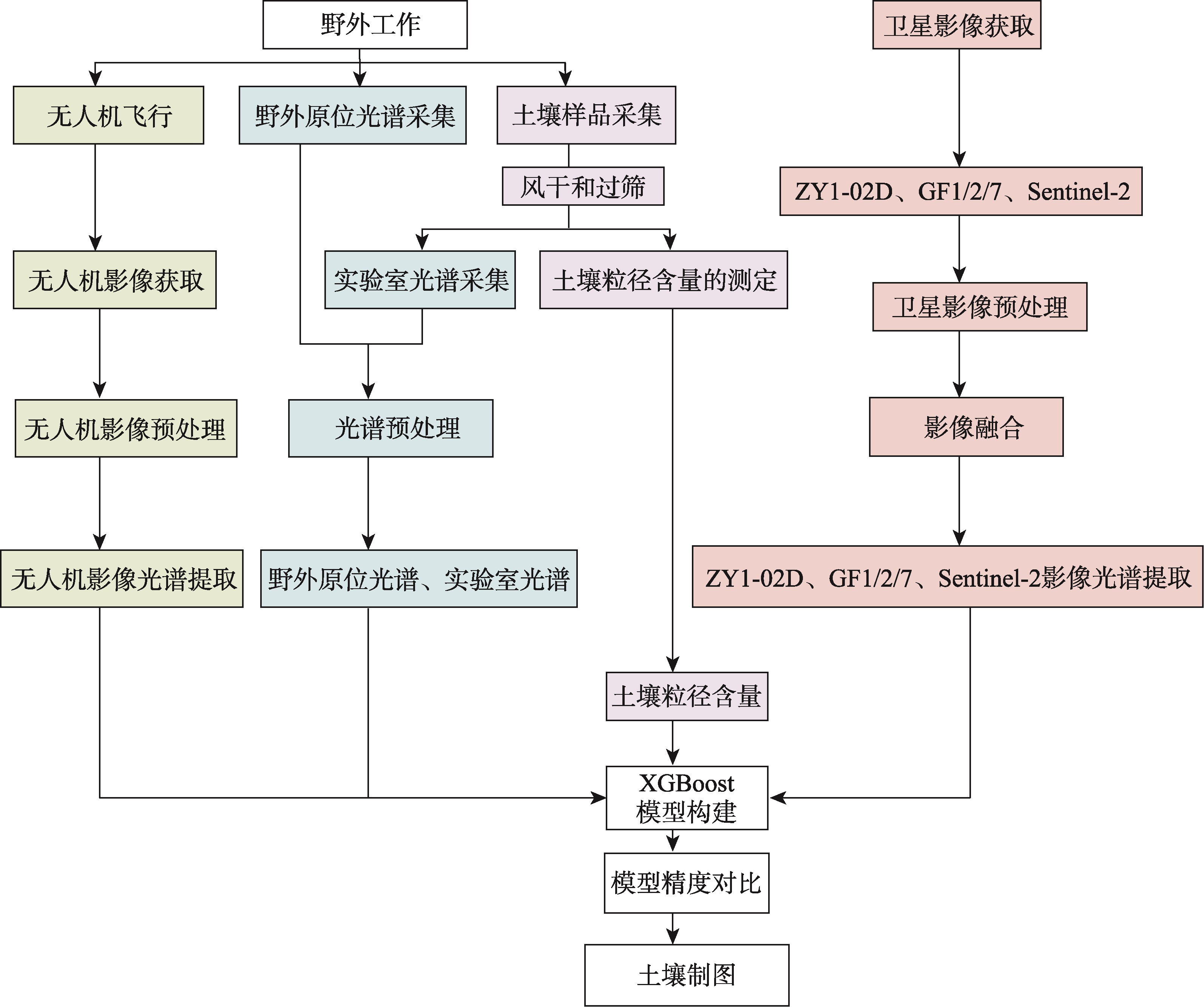
【目的】无人机及卫星遥感技术已经被成功地应用在土壤有机碳等属性的估算研究,但对土壤质地的估算相对较少,因此开展该方面的研究具有重要的应用价值。本研究以青海湟水流域互助县卓扎滩村、湟中区拦隆口镇泥隆口村和鲁沙尔镇白土庄村3个田块为研究对象,探索了无人机和卫星遥感技术在田间尺度上估算土壤质地含量的应用潜力。【方法】基于无人机平台分别搭载2台高光谱相机对各农田土壤进行无人机成像、利用地物光谱仪收集土壤野外原位光谱、采集土壤样品,共获得2022—2024年838份土壤样品;此外,获得相近时间的GF1/2/7 (Gaofen1/2/7)、Sentinel-2 A和ZY1-02D (Ziyuan 1-02D)影像数据;实验室测试各样品的土壤粒径并采集土壤室内光谱数据。在上述数据的支持下,利用XGBoost (Extreme Gradient Boosting)方法分别对土壤质地含量与实验室、野外原位、无人机、GF、ZY1-02D和Sentinel-2光谱进行统计建模与估算,进一步对土壤质地含量进行空间分布制图。【结果】① 在XGBoost方法的模型结果中,无人机影像光谱的最优模型精度RPD为2.441,GF1/2/7、ZY1-02D和Sentinel-2卫星影像的最优模型精度RPD分别为1.815、1.601和1.561; ② 基于无人机和卫星影像的估算精度要低于地物光谱仪测得的光谱估算精度,具体为:实验室光谱>野外原位光谱>无人机影像光谱>GF1/2/7卫星影像光谱>ZY1-02D卫星影像光谱>Sentinel-2卫星影像光谱;在土壤质地含量的估算结果中,黏粒含量的精度最高, RPD最高可达2.70,粉粒次之,RPD为2.24,砂粒含量的精度最低, RPD为1.91; ③ 砂粒和黏粒含量与土壤光谱反射率呈现出负相关关系,而粉粒含量则呈正相关关系,砂粒、粉粒和黏粒的敏感波段主要集中在近红外波段范围(780~2 400 nm); ④ 砂粒、粉粒和黏粒的含量在3年内变化较小,表现出相对稳定的状态,3个田块通过制图结果得到的土壤质地含量主要为:67%<砂粒≤83%、10.6%<粉粒≤19.1%和3.2%<黏粒≤6.6%。【结论】对田间尺度来说,无人机影像是土壤质地含量制图的最佳数据源,能够有效服务于精准农业管理,而GF1/2/7与ZY1-02D卫星影像基本满足质地制图的要求, Sentinel-2卫星影像对田块尺度制图则较为粗糙。

本文引用格式

宋奇 , 高小红 , 尹成卓 , 黄燕君 , 黎巧丽 , 宋玉婷 , 马旭燕 . 基于无人机、卫星影像的湟水流域田间土壤质地估算[J]. 地球信息科学学报, 2025 , 27(4) : 946 -966 . DOI: 10.12082/dqxxkx.2025.240607

Abstract

[Objectives] Unmanned Aerial Vehicle (UAV) and satellite remote sensing technologies have been successfully applied to estimate soil organic carbon and other attributes. However, their application to soil texture estimation remains relatively limited, highlighting the need for further research in this area. This study focuses on three farmland plots located in Zhuozhatan Village (Huzhu County), Nilongkou Village (Lalongkou Town, Huangzhong District), and Baitu Village (Lushar Town, Huangzhong District) within the Huangshui River Basin of Qinghai Province. It explores the potential of UAV and satellite remote sensing technologies for estimating soil texture content at the field scale. [Methods] Using UAV platforms equipped with two hyperspectral cameras, field-scale imaging of farmland soils was conducted. Additionally, a field spectrometer was used to collect in-situ soil spectra, and a total of 838 soil samples were collected from 2022 to 2024. Satellite imagery was also obtained for the same time periods, including GF1/2/7 (Gaofen 1/2/7), Sentinel-2A, and ZY1-02D (Ziyuan 1-02D). Laboratory analyses determined soil particle size distribution and acquired indoor soil spectral data. Based on these datasets, statistical modeling and soil texture content estimation were performed using the XGBoost (Extreme Gradient Boosting) method for laboratory, field in-situ, UAV, GF, ZY1-02D, and Sentinel-2 spectral data. Spatial distribution maps of soil texture content were then generated. [Results] ① Among the XGBoost model results, the highest model accuracy for UAV image spectra achieved an RPD (Ratio of Performance to Deviation) of 2.441, while the optimal RPD values for GF1/2/7, ZY1-02D, and Sentinel-2 satellite imagery were 1.815, 1.601, and 1.561, respectively. ② The estimation accuracy based on UAV and satellite imagery was lower than that derived from field spectrometer measurements. The accuracy ranking was as follows: laboratory spectra > field in-situ spectra > UAV image spectra > GF1/2/7 satellite image spectra > ZY1-02D satellite image spectra > Sentinel-2 satellite image spectra. Among soil texture components, clay content estimation showed the highest accuracy (RPD = 2.70), followed by silt (RPD = 2.24) and sand (RPD = 1.91). ③ Sand and clay content exhibited a negative correlation with soil spectral reflectance, whereas silt content displayed a positive correlation. The sensitive bands for sand, silt, and clay content were primarily concentrated in the near-infrared region (780~2 400 nm). ④ The content of sand, silt, and clay exhibited minor variations over three years, demonstrating relative stability. The mapping results for the three plots showed soil texture contents predominantly in the following ranges: 67% < sand ≤ 83%, 10.6% < silt ≤ 19.1%, and 3.2% < clay ≤ 6.6%. [Conclusions] At the field scale, UAV imagery was identified as the most effective data source for soil texture content mapping, providing strong support for precision agricultural management. While GF1/2/7 and ZY1-02D satellite imagery were found to be sufficient for texture mapping, Sentinel-2 satellite imagery was too coarse for field-scale mapping.

[1]
El Alem A, Hmaissia A, Chokmani K, et al. Quantitative study of the effect of water content on soil texture parameters and organic matter using proximal visible—Near infrared spectroscopy[J]. Remote Sensing, 2022, 14(15):3510. DOI:10.3390/rs14153510

[2]
Zheng M, Wang X, Li S J, et al. Soil texture mapping in Songnen Plain of China using sentinel-2 imagery[J]. Remote Sensing, 2023, 15(22):5351. DOI:10.3390/rs15225351

[3]
Shahriari M, Delbari M, Afrasiab P, et al. Predicting regional spatial distribution of soil texture in floodplains using remote sensing data: A case of southeastern Iran[J]. Catena, 2019,182:104149. DOI:10.1016/j.catena.2019.104149

[4]
袁浩, 姬翠翠, 杨雪梅, 等. 结合Sentinel-2数据与光谱特征的稀疏非光合植被指数构建[J]. 地球信息科学学报, 2023, 25(9):1894-1907.

DOI

[Yuan H, Ji C C, Yang X M, et al. Construction of sparse non-photosynthetic vegetation index combining sentinel-2 data and spectral features[J]. Journal of Geo-information Science, 2023, 25(9):1894-1907.] DOI:10.12082/dqxxkx.2023.220938

[5]
朱婉雪, 孙志刚, 李彬彬, 等. 基于无人机遥感的滨海盐碱地土壤空间异质性分析与作物光谱指数响应胁迫诊断[J]. 地球信息科学学报, 2021, 23(3):536-549.

DOI

[Zhu W X, Sun Z G, Li B B, et al. Analysis of spatial heterogeneity for soil attributes and spectral indices-based diagnosis of coastal saline-alkaline farmland stress using UAV remote sensing[J]. Journal of Geo-Information Science, 2021, 23(3):536-549.] DOI:10.12082/dqxxkx.2021.200144

[6]
Kaya F, Başayiğit L. Spatial prediction and digital mapping of soil texture classes in a floodplain using multinomial logistic regression[C]// Intelligent and Fuzzy Techniques for Emerging Conditions and Digital Transformation. Cham: Springer International Publishing, 2022: 463-473. DOI:10.1007/978-3-030-85577-2_55

[7]
Pavão Q S, Ribeiro P G, Maciel G P, et al. Texture prediction of natural soils in the Brazilian Amazon through proximal sensors[J]. Geoderma Regional, 2024,37:e00813. DOI:10.1016/j.geodrs.2024.e00813

[8]
王玮莹, 彭金榜, 朱婉雪, 等. 基于无人机遥感的盐渍化土壤有机质反演方法研究[J]. 地球信息科学学报, 2024, 26(3):736-752.

DOI

[Wang W Y, Peng J B, Zhu W X, et al. Study on retrieval method of soil organic matter in salinity soil using unmanned aerial vehicle remote sensing[J]. Journal of Geo-information Science, 2024, 26(3):736-752.] DOI:10.12082/dqxxkx.2024.230267

[9]
Aldana-Jague E, Heckrath G, MacDonald A, et al. UAS-based soil carbon mapping using VIS-NIR (480-1000 nm) multi-spectral imaging: Potential and limitations[J]. Geoderma, 2016, 275:55-66. DOI:10.1016/j.geoderma.2016.04.012

[10]
Pouladi N, Gholizadeh A, Khosravi V, et al. Digital mapping of soil organic carbon using remote sensing data: A systematic review[J]. Catena, 2023,232:107409. DOI:10.1016/j.catena.2023.107409

[11]
Chen F, Kissel D E, West L T, et al. Field-scale mapping of surface soil organic carbon using remotely sensed imagery[J]. Soil Science Society of America Journal, 2000, 64(2):746-753. DOI:10.2136/sssaj2000.642746x

[12]
Tan J, Ding J L, Wang Z Y, et al. Estimating soil salinity in mulched cotton fields using UAV-based hyperspectral remote sensing and a Seagull Optimization Algorithm-Enhanced Random Forest Model[J]. Computers and Electronics in Agriculture, 2024,221:109017. DOI:10.1016/j.compag.2024.109017

[13]
Feng A J, Zhou J F, Vories E D, et al. Quantifying the effects of soil texture and weather on cotton development and yield using UAV imagery[J]. Precision Agriculture, 2022, 23(4):1248-1275. DOI:10.1007/s11119-022-09883-6

[14]
Zhu W X, Rezaei E E, Nouri H, et al. Quick detection of field-scale soil comprehensive attributes via the integration of UAV and sentinel-2B remote sensing data[J]. Remote Sensing, 2021, 13(22):4716. DOI:10.3390/rs13224716

[15]
Dhiman G, Bhattacharya J, Roy S. Soil textures and nutrients estimation using remote sensing data in north India - Punjab region[J]. Procedia Computer Science, 2023, 218:2041-2048. DOI:10.1016/j.procs.2023.01.180

[16]
Castaldi F, Hueni A, Chabrillat S, et al. Evaluating the capability of the Sentinel 2 data for soil organic carbon prediction in croplands[J]. ISPRS Journal of Photogrammetry and Remote Sensing, 2019, 147:267-282. DOI:10.1016/j.isprsjprs.2018.11.026

[17]
Shi F F, Gao X H, Li R X, et al. Ensemble learning for the land cover classification of loess hills in the eastern Qinghai-Tibet Plateau using GF-7 multitemporal imagery[J]. Remote Sensing, 2024, 16(14):2556. DOI:10.3390/rs16142556

[18]
何婧, 屈忠义, 刘霞, 等. 杭锦后旗不同盐渍土沙穴种植番茄对土壤水热盐的响应[J]. 干旱区研究, 2021, 38(3):682-694.

DOI

[He J, Qu Z Y, Liu X, et al. Effect of planting tomato in sand cave on water, heat and salt transport in different saline soil in Hanggin Rear Banner[J]. Arid Zone Research, 2021, 38(3):682-694.] DOI:10.13866/j.azr.2021.03.10

[19]
Song Q, Gao X H, Song Y T, et al. Estimation and mapping of soil texture content based on unmanned aerial vehicle hyperspectral imaging[J]. Scientific Reports, 2023, 13(1):14097. DOI:10.1038/s41598-023-40384-2

PMID

[20]
郭慧婷, 韩波, 王雪, 等. 资源一号02D卫星高光谱与多光谱遥感影像融合方法[J]. 航天器工程, 2020, 29(6):180-185.

[Guo H T, Han B, Wang X, et al. Hyperspectral and multispectral remote sensing images fusion method of ZY-1-02D satellite[J]. Spacecraft Engineering, 2020, 29(6):180-185.] DOI:10.3969/j.issn.1673-8748.2020.06.027

[21]
田义超, 郑丹琳, 张强, 等. 基于国产资源一号02D卫星和机器学习算法的钦州湾滨海土壤盐分反演[J]. 中国环境科学, 2024, 44(1):371-385.

[Tian Y C, Zheng D L, Zhang Q, et al. Inversion of coastal soil salinity in Qinzhou Bay based on domestic resources-1 02D satellite and machine learning algorithm[J]. China Environmental Science, 2024, 44(1):371-385.] DOI:10.19674/j.cnki.issn1000-6923.20230823.013

[22]
Chen Y, Ma L X, Yu D S, et al. Comparison of feature selection methods for mapping soil organic matter in subtropical restored forests[J]. Ecological Indicators, 2022,135:108545. DOI:10.1016/j.ecolind.2022.108545

[23]
Chang C W, Laird D A, Mausbach M J, et al. Near-infrared reflectance spectroscopy-principal components regression analyses of soil properties[J]. Soil Science Society of America Journal, 2001, 65(2):480-490. DOI:10.2136/sssaj2001.652480x

[24]
Quesney A, Le Hégarat-Mascle S, Taconet O, et al. Estimation of watershed soil moisture index from ERS/SAR data[J]. Remote Sensing of Environment, 2000, 72(3):290-303. DOI:10.1016/S0034-4257(99)00102-9

[25]
Ma C D, Xu X H, Zhou M, et al. A deep learning approach for chromium detection and characterization from soil hyperspectral data[J]. Toxics, 2024, 12(5):357. DOI:10.3390/toxics12050357

[26]
Gholizadeh A, Daniel Ž, Saberioon M, et al. Soil organic carbon and texture retrieving and mapping using proximal, airborne and Sentinel-2 spectral imaging[J]. Remote Sensing of Environment, 2018, 218:89-103. DOI:10.1016/j.rse.2018.09.015

[27]
孙问娟, 李新举. 煤矿区土壤有机碳含量的高光谱预测模型[J]. 水土保持学报, 2018, 32(5):346-351.

[Sun W J, Li X J. Hyperspectral prediction model of soil organic carbon content in coal mining area[J]. Journal of Soil and Water Conservation, 2018, 32(5):346-351.] DOI:10.13870/j.cnki.stbcxb.2018.05.054

[28]
Richer-de-Forges A C, Arrouays D, Chen S C, et al. Hand-feel soil texture and particle-size distribution in central France. Relationships and implications[J]. Catena, 2022,213:106155. DOI:10.1016/j.catena.2022.106155

[29]
Omondiagbe O P, Lilburne L, Licorish S A, et al. Soil texture prediction with automated deep convolutional neural networks and population-based learning[J]. Geoderma, 2023,436:116521. DOI:10.1016/j.geoderma.2023.116521

[30]
李天乐, 赵泉华, 贾淑涵, 等. 土壤有机质含量反演方法:土壤高光谱数据微分-瞬时频率变换[J]. 地球信息科学学报, 2024, 26(7):1733-1744.

DOI

[Li T L, Zhao Q H, Jia S H, et al. Soil organic matter content inversion methods: Differential-instantaneous frequency transform of soil hyperspectral data[J]. Journal of Geo-information Science, 2024, 26(7):1733-1744.] DOI:10.12082/dqxxkx.2024.240120

[31]
Ye M, Zhu L, Li X J, et al. Estimation of the soil arsenic concentration using a geographically weighted XGBoost model based on hyperspectral data[J]. Science of the Total Environment, 2023,858:159798. DOI:10.1016/j.scitotenv.2022.159798

[32]
Volkan Bilgili A, van Es H M, Akbas F, et al. Visible-near infrared reflectance spectroscopy for assessment of soil properties in a semi-arid area of Turkey[J]. Journal of Arid Environments, 2010, 74(2):229-238. DOI:10.1016/j.jaridenv.2009.08.011

[33]
Awiti A O, Walsh M G, Shepherd K D, et al. Soil condition classification using infrared spectroscopy: A proposition for assessment of soil condition along a tropical forest-cropland chronosequence[J]. Geoderma, 2008, 143(1/2):73-84. DOI:10.1016/j.geoderma.2007.08.021

[34]
Sankey J B, Sankey T T, Li J R, et al. Quantifying plant-soil-nutrient dynamics in rangelands: Fusion of UAV hyperspectral-LiDAR, UAV multispectral-photogrammetry, and ground-based LiDAR-digital photography in a shrub-encroached desert grassland[J]. Remote Sensing of Environment, 2021,253:112223. DOI:10.1016/j.rse.2020.112223

[35]
Zhu C M, Ding J L, Zhang Z P, et al. SPAD monitoring of saline vegetation based on Gaussian mixture model and UAV hyperspectral image feature classification[J]. Computers and Electronics in Agriculture, 2022,200:107236. DOI:10.1016/j.compag.2022.107236

文章导航

/