
矢量线全球离散格网系统高精度建模方法
作者贡献:Author Contributions
丁俊杰和贲进参与实验设计;丁俊杰、代金池和王蕊完成实验操作;丁俊杰、贲进参与论文的写作和修改。所有作者均阅读并同意最终稿件的提交。
The study was designed by DING Junjie and BEN Jin. The experimental operation was completed by DING Junjie, DAI Jinchi and WANG Rui. The manuscript was drafted and revised by DING Junjie and BEN Jin. All the authors have read the last version of paper and consented for submission.
|
丁俊杰(2000—),男,湖南常德人,博士生,主要从事全球离散格网系统研究。E-mail: dingjunjie0510@126.com |
收稿日期: 2024-12-23
修回日期: 2025-03-17
网络出版日期: 2025-06-06
基金资助
网信“十四五”规划项目(145BWX023009000X)
Methods of High-Precision Vector Line Modeling in Discrete Global Grid Systems
Received date: 2024-12-23
Revised date: 2025-03-17
Online published: 2025-06-06
Supported by
The “14th Five-Year” Plan Project for National Informatization(145BWX023009000X)
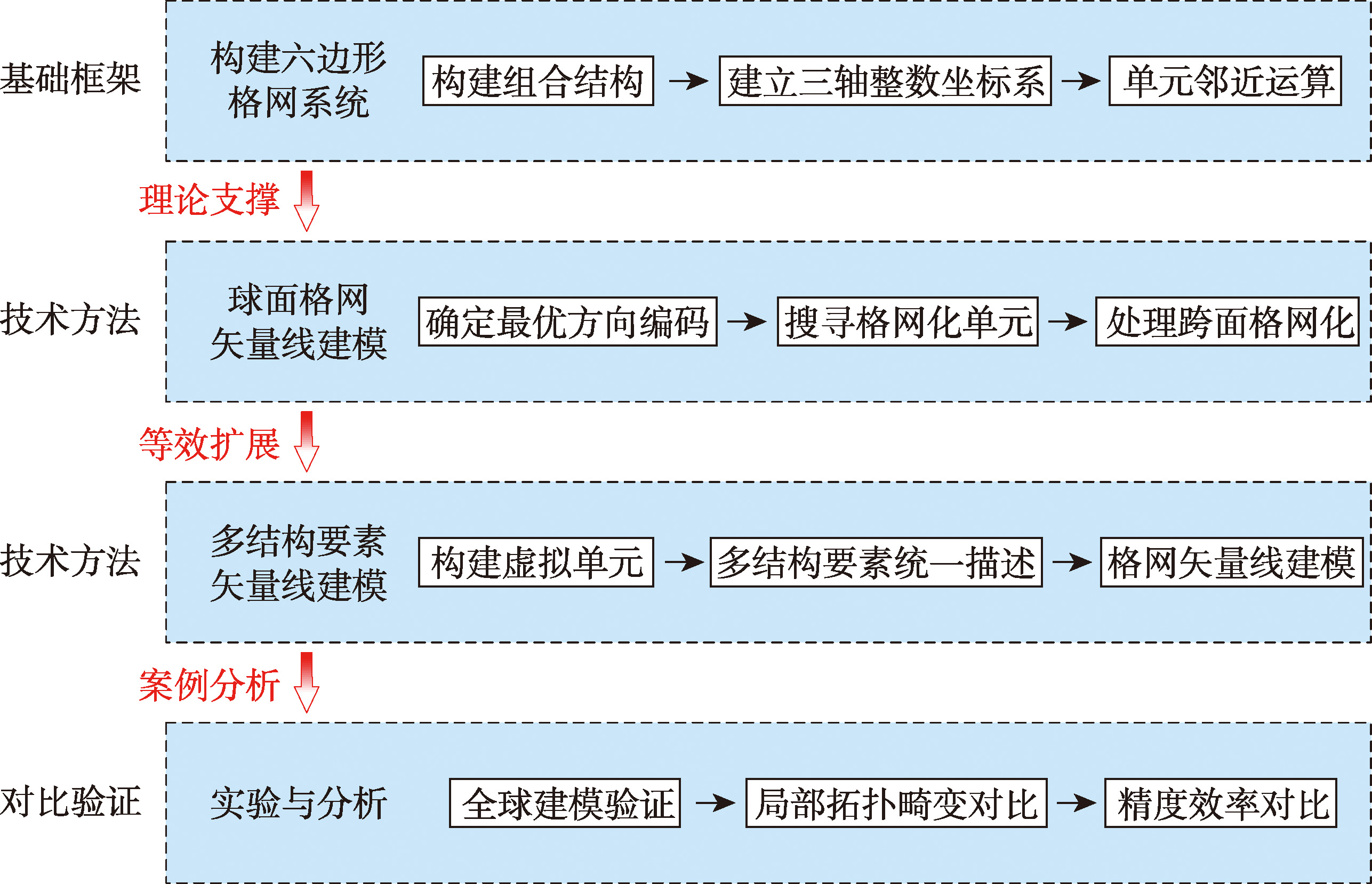
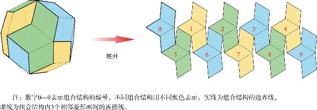
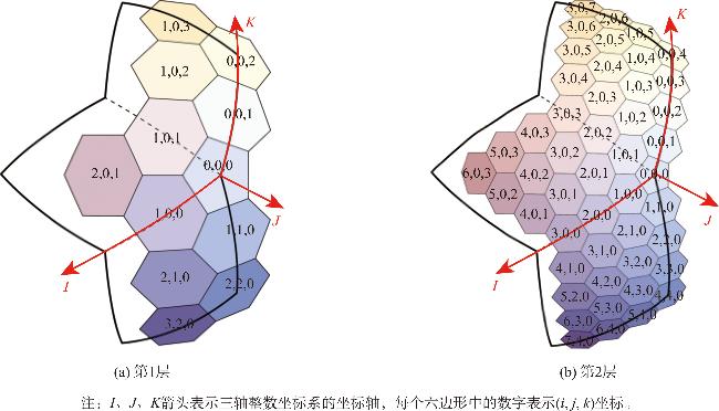
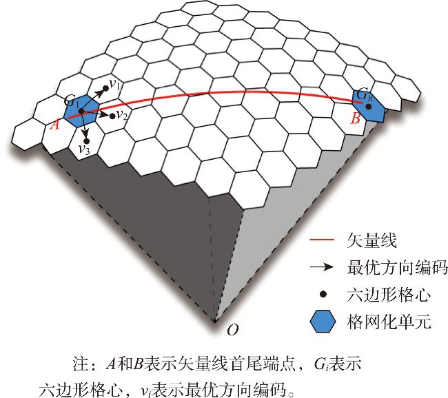
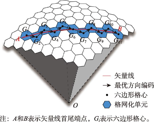
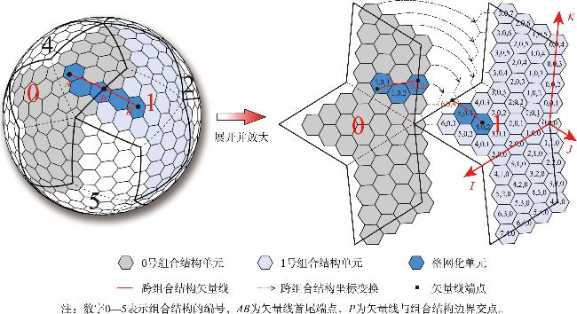
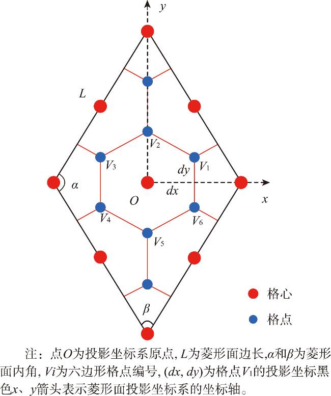
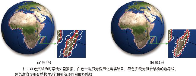
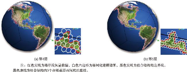
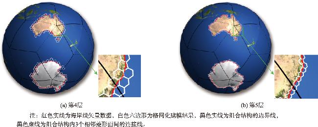
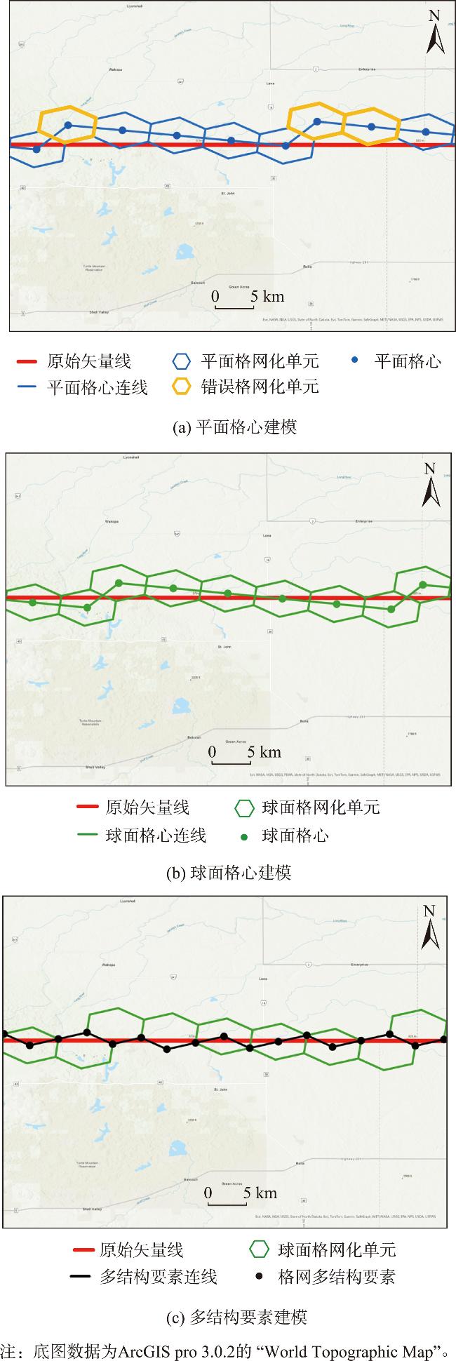
【目的】全球离散格网系统(Discrete Global Grid Systems,DGGS)本质上是多尺度栅格结构,地理空间矢量与格网的集成是难点,矢量线格网化是其中的基本问题。现有方案多以平面格网单元中心(格心)连线为矢量线建模结果,但扩展到球面后建模精度降低,本文针对这一缺陷提出矢量线全球离散格网系统高精度建模方法。【方法】首先选择与地球拟合程度更高的菱形三十面体构建六边形格网系统,以3个相邻菱形面构成组合结构并建立三轴整数坐标系描述单元空间位置;然后根据矢量线首尾端点所在单元确定最优方向编码以减少搜索范围,通过编码邻近运算搜索矢量线经过的球面单元,以球面格心连线为建模结果并提出跨面矢量线处理方法;最后增加单元顶点(格点)作为结构要素,实现多结构要素矢量线建模,进一步提高建模精度。【结果】实验结果表明:本文方案能正确实现全球各个大洲海岸线格网化建模,确保格网化单元与矢量线拓扑相交,且相较平面格网建模结果兼具精度和效率优势。【结论】针对传统矢量数据格网建模方法的几何精度损失和拓扑畸变问题,本文提出高精度球面格网化建模方法,为矢量数据转换至格网同构处理提供有力支撑。
丁俊杰 , 贲进 , 代金池 , 王蕊 . 矢量线全球离散格网系统高精度建模方法[J]. 地球信息科学学报, 2025 , 27(6) : 1275 -1288 . DOI: 10.12082/dqxxkx.2025.240705
[Objectives] Discrete Global Grid System (DGGS) is a hierarchical structure with seamless global coverage. It functions similarly to an electronic table covering the Earth, supporting the processing and analysis of heterogeneous geospatial data. However, the grid is essentially a multi-scale raster structure, and integrating geographic vector data into it remains a challenge in both research and application. Vector data includes points, lines, and polygons, among which vector line gridding is a fundamental problem. Most existing solutions express vector lines using the center lines of grid cells on a planar grid. However, when extended to spherical surfaces, the accuracy of vector data modeling decreases, making it difficult to meet application requirements. [Methods] This paper proposes a high-precision modeling method for vector lines in DGGS. First, a hexagonal global discrete grid is constructed based on the rhombic triacontahedron, which offers a higher degree of conformity to the sphere. Three adjacent rhombic faces are combined to form a composite structure, and a three-axis integer coordinate system is established to describe the spatial positions of hexagonal elements. Based on the grid cells corresponding to the start and end points of the vector line, optimal direction codes are determined to reduce the search range. The great arc of the vector line passing through the cells is identified using a neighborhood encoding operation. The resulting model is constructed based on the connecting line between grid centers, and a method for processing cross-surface vector lines is proposed. Finally, grid vertices are introduced as structural elements to enable vector line modeling using multiple structural elements, further improving the accuracy of hexagonal grid-based vector line modeling. Experiments show that the proposed method successfully models the grid representation of major coastlines across different continents. The results ensure that the grid model intersects with the original vector line topology, avoiding topological errors where original vector lines do not intersect with any grid cells.[Results] Compared with planar grid modeling, the proposed method achieves significantly higher accuracy in vector line gridding across various coastal regions worldwide. The modeling results demonstrate strong stability and are nearly unaffected by the resolution of the original vector data. Moreover, the method maintains an efficiency advantage, even after complex geometric operations on the spherical surface. [Conclusions] To address the geometric accuracy loss and topological distortion issues in traditional vector data grid modeling, this paper proposes a high-precision spherical grid modeling method. The approach shows strong potential to support the conversion of vector data to grid-based isomorphic representations.
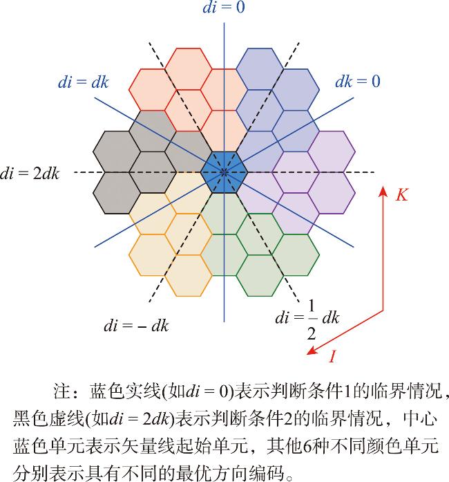
表1 单元坐标与最优方向编码的关系Tab. 1 Correspondence between the coordinates of cells and optimal direction codes |
| 判断条件1 | 最邻近最优方向编码 | 判断条件2 | 第三最优方向编码 |
|---|---|---|---|
| di <0, dk ≥0 | v1=(-1, 0, 0), v2=(0, 0, 1) | di<-dk | v3=(-1, 0, -1) |
| di≥-dk | v3=(1, 0, 1) | ||
| di ≥0, dk >di | v1=(0, 0, 1), v2=(1, 0, 1) | v3=(-1, 0, 0) | |
| v3=(1, 0, 0) | |||
| di ≥dk,dk >0 | v1=(1, 0, 1), v2=(1, 0, 0) | di<2dk | v3=(0, 0, 1) |
| di≥2dk | v3=(0, 0, -1) | ||
| di >0, dk ≤0 | v1=(1, 0, 0), v2=(0, 0, -1) | di>-dk | v3=(1, 0, 1) |
| di≤-dk | v3=(-1, 0, -1) | ||
| di ≥0, di >dk | v1=(0, 0, -1), v2=(-1, 0, -1) | v3=(1, 0, 0) | |
| v3=(-1, 0, 0) | |||
| di ≤ dk, dk <0 | v1=(-1, 0, -1), v2=(-1, 0, 0) | di>2dk | v3=(0, 0, -1) |
| di≤2dk | v3=(0, 0, 1) |
表2 跨组合结构单元坐标变换Tab. 2 Coordinate transformation for cells of crossing combined structures |
| 序号 | 变换前 单元位置 | 变换后 单元位置 | 旋转矩阵R | 平移矩阵T |
|---|---|---|---|---|
| 1 | S1(0) | S1(0) | ||
| 2 | S1(0) | S1(1) | ||
| 3 | S1(1) | S2(0) | ||
| 4 | S1(2) | S2(0) | ||
| 5 | S1(2) | S2(1) | ||
| 6 | S2(0) | S1(1) | ||
| 7 | S2(0) | S1(2) | ||
| 8 | S2(1) | S1(2) | ||
| 9 | S2(2) | S2(2) | ||
| 10 | S2(2) | S2(1) |
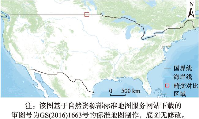
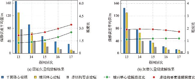
表3 原始矢量线建模结果Tab. 3 Modeling results of the original vector lines |
| 格网 层次 | 平面格心 建模/m | 球面格心 建模/m | 球面格心建模精度比 | 多结构要 素建模/m | 多结构要素建模精度比 |
|---|---|---|---|---|---|
| 13 | 166.330 | 130.199 | 1.278 | 76.772 | 2.167 |
| 14 | 91.935 | 66.797 | 1.376 | 39.910 | 2.304 |
| 15 | 54.960 | 34.713 | 1.583 | 21.487 | 2.558 |
| 16 | 37.499 | 19.094 | 1.964 | 12.582 | 2.980 |
| 17 | 29.055 | 11.407 | 2.547 | 8.411 | 3.454 |
表4 加密矢量线建模结果Tab. 4 Modeling results of the vector lines with increased density |
| 格网 层次 | 平面格心 建模/m | 球面格心 建模/m | 球面格心建模精度比 | 多结构要 素建模/m | 多结构要素建模精度比 |
|---|---|---|---|---|---|
| 13 | 145.557 | 130.138 | 1.118 | 75.856 | 1.919 |
| 14 | 76.381 | 65.868 | 1.160 | 38.992 | 1.959 |
| 15 | 40.278 | 33.910 | 1.188 | 20.844 | 1.932 |
| 16 | 22.072 | 18.475 | 1.195 | 11.745 | 1.863 |
| 17 | 12.751 | 10.621 | 1.200 | 7.330 | 1.739 |
利益冲突:Conflicts of Interest 所有作者声明不存在利益冲突。
All authors disclose no relevant conflicts of interest.
| [1] |
关丽, 程承旗, 吕雪锋. 基于球面剖分格网的矢量数据组织模型研究[J]. 地理与地理信息科学, 2009, 25(3):23-27.
[
|
| [2] |
赵学胜, 贲进, 孙文彬, 等. 地球剖分格网研究进展综述[J]. 测绘学报, 2016, 45(S1):1-14.
[
|
| [3] |
周成虎, 欧阳, 马廷. 地理格网模型研究进展[J]. 地理科学进展, 2009, 28(5):657-662.
[
|
| [4] |
|
| [5] |
|
| [6] |
赵学胜, 王磊, 王洪彬, 等. 全球离散格网的建模方法及基本问题[J]. 地理与地理信息科学, 2012, 28(1):29-34.
[
|
| [7] |
|
| [8] |
|
| [9] |
|
| [10] |
|
| [11] |
|
| [12] |
|
| [13] |
|
| [14] |
周建彬, 贲进, 丁俊杰, 等. 多结构要素六边形全球离散格网系统构建方法及应用[J]. 地球信息科学学报, 2023, 25(11):2107-2119.
[
|
| [15] |
周建彬, 贲进, 黄心海, 等. 广域六角格兵棋地图构建方法与机动推演应用[J]. 系统工程与电子技术, 2023, 45(3):769-776.
[
|
| [16] |
|
| [17] |
|
| [18] |
|
| [19] |
|
| [20] |
练文杰. 基于全球离散格网的地理对象模型及关键技术研究[D]. 南京: 南京师范大学, 2019.
[
|
| [21] |
|
| [22] |
|
| [23] |
于文率, 童晓冲, 贲进, 等. 全球六边形离散格网的矢量线数据绘制精度控制[J]. 地球信息科学学报, 2015, 17(7):804-809.
[
|
| [24] |
杜灵瑀. 矢量线六边形全球离散格网表达的理论与方法[D]. 郑州: 战略支援部队信息工程大学, 2019.
[
|
| [25] |
|
| [26] |
陈艺航, 王金鑫, 曹泽宁, 等. 全球离散格网系统结构要素一体化编码与生成方法[J]. 地球信息科学学报, 2021, 23(8):1382-1390.
[
|
| [27] |
|
| [28] |
|
| [29] |
|
/
| 〈 |
|
〉 |