
Journal of Geo-information Science >
Relationship Between DEM Resolution and Average Slope Derived from DEM
*The author: CHEN Nan, E-mail:fjcn99@163.com
Received date: 2013-08-13
Request revised date: 2013-12-16
Online published: 2014-07-10
Copyright
At present, slopes are usually derived from discrete DEMs. When deriving slope from DEM, the variation of DEM resolution will cause changes in the slope values which are extracted from the local grids. The variation will be significant in understating the general rule of the variation of average slope with respect to DEM resolution. 8 areas representing the typical geomorphology in Loess Plateau were chosen as the sample areas, and the DEMs with a 5m resolution were established according to the topographic map scaled at 1:10 000. In every sample area, 22 500 sampling points were selected, and the slopes which were derived according to the algorithm of third-order finite difference weighted by reciprocal of squared distance on the sampling points were taken as the research object. The regression analysis, single-factor variance analysis, contrast analysis were adopted to analyze the rule of the influence of DEM resolution on grid slopes. The following conclusions were obtained: (1) the average slope may increase as the resolution of DEM becomes coarser; (2) in all the sample areas, with the resolution becoming coarser, the number of the grids with negative slope error is at least 1.13 times of the grids with positive slope error. The amplitude of average slope of the grids with negative slope error is greater than 3.1 times of the latter. The number of grids with decreasing slopes is 1.81-4.04 times of the grids with increasing slopes; (3) the change of average slope can be explained in this research by combining the author proposed index with the previously mentioned conclusion (2); (4) the number of grids with varied slope values is not sensitive to the resolution of DEM. The slopes of the grids which have positive slope error or negative slope error are intensively distributed in certain intervals of slopes that derived from the DEMs with 5m resolution. The intervals are not sensitive to the resolutions of DEM; (5) the total slope error can be computed, according to the empirical formula proposed in this research and calculated from the DEM resolution and the average slope of DEM with a 5m resolution.
Key words: DEM; slope; error; resolution
CHEN Nan* . Relationship Between DEM Resolution and Average Slope Derived from DEM[J]. Journal of Geo-information Science, 2014 , 16(4) : 524 -530 . DOI: 10.3724/SP.J.1047.2014.00524
Fig.1 Sketch map of the topographic profile图1 地形剖面示意图 |
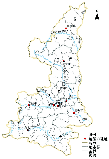
Tab.1 Basic information of the sample areas表1 样区基本情况表 |
| 样区编号 | 样区名称 | 平均坡度(º) | 海拔高度范围(m) | 地貌类型 |
|---|---|---|---|---|
| 1 | 安塞 | 37.92 | 500~1846 | 黄土高原丘陵沟壑区 |
| 2 | 长武 | 13.32 | 161~1215 | 黄土塬 |
| 3 | 淳化 | 12.41 | 768~1188 | 黄土塬梁状丘陵区 |
| 4 | 富县 | 26.76 | 1147~1459 | 黄土梁峁状丘陵沟壑区 |
| 5 | 神木 | 9.45 | 1035~1323 | 风沙黄土过渡区域 |
| 6 | 绥德 | 26.39 | 820~1180 | 黄土梁峁状丘陵沟壑区 |
| 7 | 延川 | 31.30 | 923~1252 | 黄土梁峁状丘陵沟壑区 |
| 8 | 宜君 | 19.26 | 767~1158 | 黄土梁状丘陵区 |
Fig.2 Geographic sketch map of the sample areas图2 样区所在地理位置示意图 |
Fig.3 Sketch map of deriving slope from DEM with different resolutions图3 不同分辨率DEM的坡度计算示意图 |
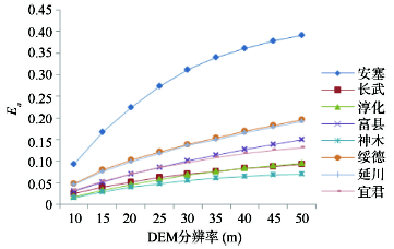
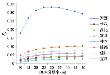
Fig.4 The curves of from the DEMs with different resolutions in sample areas图4 各样区不同分辨率DEM对应的变化曲线图 |
Fig.5 The curves of from the DEMs with different resolutions in sample areas图5 各样区不同分辨率DEM对应的变化曲线图 |
Fig.6 The curves of from the DEMs with different resolutions in sample areas图6 各样区不同分辨率DEM对应的变化曲线图 |
Tab.2 Statistical parameters of the grids with negative or positive slope error表2 正误差与负误差栅格统计参数表 |
| 比较项 | 样区 | |||||||
|---|---|---|---|---|---|---|---|---|
| 安塞 | 长武 | 淳化 | 富县 | 神木 | 绥德 | 延川 | 宜君 | |
| 一直保持正误差的栅格个数(个) | 5042 | 4137 | 4093 | 3548 | 3350 | 3644 | 2791 | 4237 |
| 一直保持正误差的栅格个数与10m DEM正误差栅格个数之比(%) | 57.96 | 44.63 | 48.73 | 36.63 | 43.67 | 38.93 | 31.72 | 44.19 |
| 一直保持负误差的栅格个数(个) | 9121 | 9256 | 10 235 | 10 078 | 11 311 | 10 551 | 11 288 | 9038 |
| 一直保持负误差的栅格个数与 10 m DEM负误差栅格个数之比(%) | 92.27 | 72.40 | 72.68 | 78.66 | 76.31 | 85.33 | 82.42 | 70.27 |
Tab.3 Percentage of the grids with positive slope error on every slope grade in Suide sample area(%)表3 绥德样区不同坡度级别的正误差栅格数量百分比(%) |
| 分辨率(m) | 坡度分级编号 | ||||||||
|---|---|---|---|---|---|---|---|---|---|
| 1 | 2 | 3 | 4 | 5 | 6 | 7 | 8 | 9 | |
| 10 | 0.00 | 0.00 | 0.00 | 0.00 | 66.04 | 32.35 | 1.61 | 0.00 | 0.00 |
| 15 | 0.00 | 0.00 | 0.00 | 0.00 | 64.88 | 33.45 | 1.67 | 0.00 | 0.00 |
| 20 | 0.00 | 0.00 | 0.00 | 0.00 | 62.94 | 35.30 | 1.76 | 0.00 | 0.00 |
| 25 | 0.00 | 0.00 | 0.00 | 0.00 | 60.10 | 38.00 | 1.90 | 0.00 | 0.00 |
| 30 | 0.00 | 0.00 | 0.00 | 0.00 | 56.59 | 41.35 | 2.06 | 0.00 | 0.00 |
| 35 | 0.00 | 0.00 | 0.00 | 0.00 | 52.76 | 45.00 | 2.24 | 0.00 | 0.00 |
| 40 | 0.00 | 0.00 | 0.00 | 0.00 | 48.44 | 49.12 | 2.45 | 0.00 | 0.00 |
| 45 | 0.00 | 0.00 | 0.00 | 0.00 | 44.14 | 53.21 | 2.65 | 0.00 | 0.00 |
| 50 | 0.00 | 0.00 | 0.00 | 0.00 | 39.62 | 57.51 | 2.87 | 0.00 | 0.00 |
Tab.4 Percentage of the grids with negative slope error on every slope grade in Suide sample area (%)表4 绥德样区不同坡度级别的负误差栅格数量百分比(%) |
| 分辨率(m) | 坡度分级编号 | ||||||||
|---|---|---|---|---|---|---|---|---|---|
| 1 | 2 | 3 | 4 | 5 | 6 | 7 | 8 | 9 | |
| 10 | 82.06 | 0.10 | 0.39 | 6.76 | 10.69 | 0.00 | 0.00 | 0.00 | 0.00 |
| 15 | 71.72 | 0.12 | 0.56 | 9.13 | 18.47 | 0.00 | 0.00 | 0.00 | 0.00 |
| 20 | 63.54 | 0.20 | 0.90 | 11.46 | 23.90 | 0.00 | 0.00 | 0.00 | 0.00 |
| 25 | 55.74 | 0.37 | 1.36 | 13.02 | 29.51 | 0.00 | 0.00 | 0.00 | 0.00 |
| 30 | 48.78 | 0.50 | 2.05 | 15.34 | 33.32 | 0.00 | 0.00 | 0.00 | 0.00 |
| 35 | 43.14 | 0.69 | 2.83 | 17.97 | 35.38 | 0.00 | 0.00 | 0.00 | 0.00 |
| 40 | 38.27 | 1.02 | 3.41 | 20.51 | 36.80 | 0.00 | 0.00 | 0.00 | 0.00 |
| 45 | 34.49 | 1.36 | 3.98 | 23.38 | 36.79 | 0.00 | 0.00 | 0.00 | 0.00 |
The authors have declared that no competing interests exist.
| [1] |
|
| [2] |
|
| [3] |
|
| [4] |
|
| [5] |
|
| [6] |
|
| [7] |
|
| [8] |
|
| [9] |
|
| [10] |
|
| [11] |
|
| [12] |
|
| [13] |
|
| [14] |
|
| [15] |
|
| [16] |
|
| [17] |
|
| [18] |
|
/
| 〈 |
|
〉 |

