
Journal of Geo-information Science >
The Optimization of the Search Area in a Search and Rescue Process based on GIS
Received date: 2013-08-24
Request revised date: 2013-10-31
Online published: 2014-07-10
Copyright
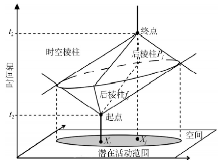
Nowadays, people are more likely to participate in outdoor activities which results in the increase of people’s missing. In the process of search and rescue, the application of geographic information technology is able to help the search team to narrow the search area and allocate the search resources. As a result, GIS’ application improves the efficiency and saves time and cost. This paper firstly discussed the role of GIS in determining the search area and allocating the search resources in the search and rescue process. Then, based on time-geography tools, this paper optimized the search process on considering that time is a continuous variable. Space-time prism, which is one of the most important tools in time-geography theory, was used to express the spatio-temporal constraints of missing person as well as the search teams. The missing person can only be found in places where both the rescue team and missing person can reach at the same time. The aim of an optimization for the research and rescue process is to find the right place where both the missing person and the search team can arrive at the same time. In the spatio-temporal environment, this kind of place is the intersection of both sides’ space-time prisms. So, the search team only needs to search people in the intersection time and space of the prisms. In this way, the search area was narrowed and the time period was identified more precisely. When other search teams joins in the search process, the final search area is obtained after the intersection of every resource’s search area is calculated. At the same time, the search boundary for each resource is also obtained. Each resource can take actions according to its search boundary. This paper used ArcGIS software platform to achieve the optimization process. A search and rescue process using simulated data was presented afterwards. Compared with traditional buffer analysis method, the search area calculated from this method is smaller and the search time is more precise. This method can be used in combination with other methods to improve the efficiency, save cost, as well as allocate the research resources in a search and rescue process.
Key words: search and rescue; spatio-temporal constraints; space-time prism; search area; GIS
LIU Zhao , LUO Zhide , ZHANG Yaofang , WANG Yuan . The Optimization of the Search Area in a Search and Rescue Process based on GIS[J]. Journal of Geo-information Science, 2014 , 16(4) : 531 -536 . DOI: 10.3724/SP.J.1047.2014.00531
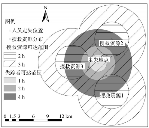
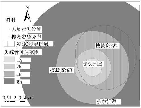
Fig.1 To determine the search area using the buffer analysis图1 利用缓冲区分析求解搜寻的空间范围 |
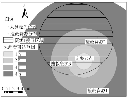
Fig.3 The optimal search area when only using search resource 1图3 单用搜救资源1时的最优搜寻范围 |
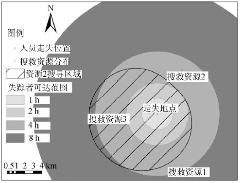
Fig.4 The optimal search area when only using search resource 2图4 单用搜救资源2时的最优搜寻范围 |
Fig.5 The optimal search area when only using search resource 3图5 单用搜救资源3时的最优搜寻范围 |
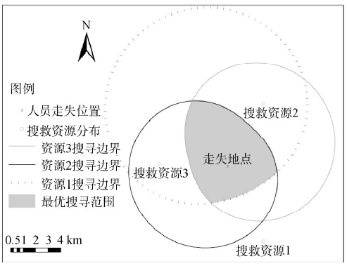
Fig.6 The optimal search area when using all search resources图6 3个搜救资源联合使用时的搜寻范围 |
The authors have declared that no competing interests exist.
| [1] |
|
| [2] |
|
| [3] |
|
| [4] |
|
| [5] |
|
| [6] |
|
| [7] |
|
| [8] |
|
| [9] |
|
| [10] |
|
| [11] |
|
| [12] |
|
| [13] |
|
| [14] |
|
| [15] |
|
| [16] |
|
| [17] |
|
| [18] |
|
| [19] |
|
| [20] |
|
| [21] |
|
| [22] |
|
| [23] |
|
| [24] |
|
/
| 〈 |
|
〉 |