
Journal of Geo-information Science >
Research on Connecting PS-InSAR Results from Adjacent Tracks for Land Subsidence Monitoring
Received date: 2013-11-15
Request revised date: 2014-03-26
Online published: 2014-09-04
Copyright
At present, more and more economic developed areas are facing serious land subsidence problems with increasing coverage and intensity, which prevents the application of sustainable development in these areas. Thus, the land subsidence problems should be controlled urgently. PS-InSAR technology, as one of the most important tools to detect land subsidence, has played a significant role in land subsidence monitoring. However, multi-track PS-InSAR results must be connected to obtain the large scale subsidence map when an extended land subsidence survey area is required, since spaceborne SAR image from only one track is too limited in scan range to cover the whole area. This paper analyzes the processing chain of PS-InSAR and points out two key problems when connecting multi-track PS-InSAR results from adjacent tracks. First, many PS from adjacent tracks are physically different, which is mainly caused by different incidence angles and coherences of adjacent tracks. Therefore, it is hard to find the tie point in the overlapped area. Second, there is a subsidence offset between two adjacent tracks according to the overlapped area, which is attributed to the physical differences of PS and the processing parameters of PS-InSAR, such as the reference point, the temporal coverage and so on. Among these factors, impacts caused by different incidence angles and reference offset are emphasized. Two new methods, Block Method and Interpolation Method, are proposed in this paper to calculate the differences between subsidence velocities from adjacent tracks caused by the physical differences of PS in the overlapped area. This can avoid the difficulty of finding tie point in the overlapped area. Moreover, subsidence velocities are adjusted to mitigate the impacts from different incidence angles. Finally, based on the existing software, a complete procedure for multi-track PS-InSAR subsidence results connection is demonstrated. At the end of this paper, ENVISAT ASAR datasets of Pearl Delta River in Guangdong province are processed and analyzed in experiments. Experimental results show that different incidence angles could affect the land subsidence from adjacent tracks, so it is necessary to correct the differential subsidence caused by the incidence difference, especially when multiple tracks are involved. Block Method and Interpolation Method are all effective in calculating the differences of subsidence velocities, and Block Method was superior to Interpolation Method through statistical analyses. Meanwhile, different incidence angles and reference offset are effectively mitigated to obtain the conformed subsidence velocities using these two methods. Consequently, PS-InSAR subsidence velocities from two ENVISAT tracks are connected effectively, which shows the effectiveness of the processing procedure proposed in this paper.
Key words: PS-InSAR; PS point; land subsidence; subsidence velocity; multi-track connection
XIONG Siting , ZENG Qiming , JIAO Jian , ZHANG Xiaojie . Research on Connecting PS-InSAR Results from Adjacent Tracks for Land Subsidence Monitoring[J]. Journal of Geo-information Science, 2014 , 16(5) : 797 -805 . DOI: 10.3724/SP.J.1047.2014.00797
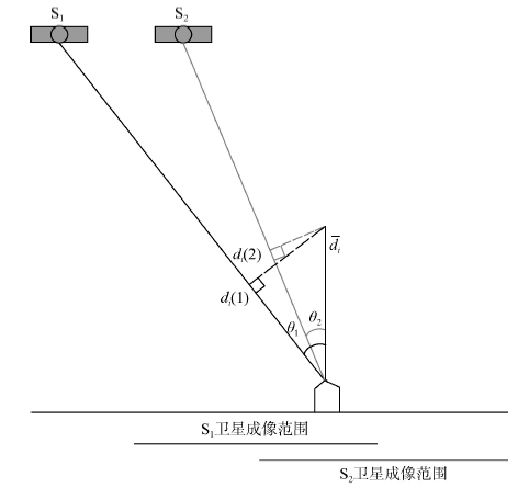
Fig.1 Subsidence monitoring from adjacent tracks.图1 相邻轨道地面沉降观测示意图 |
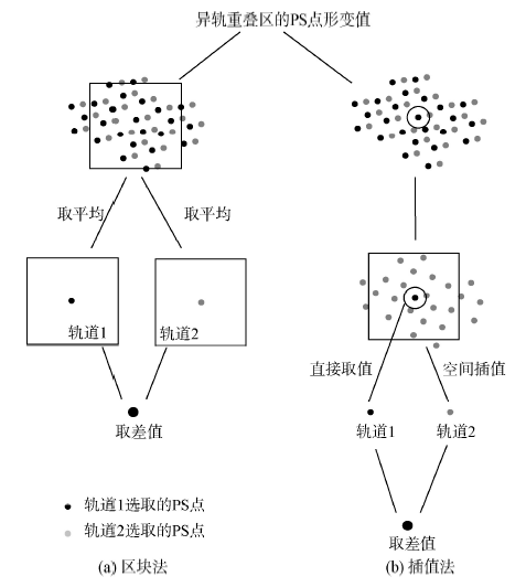
Fig.2 Block Method and Interpolation Method to calculate subsidence velocity differences between adjacent tracks.图2 像元法和插值法求重叠区域异轨形变速率差原理图 |
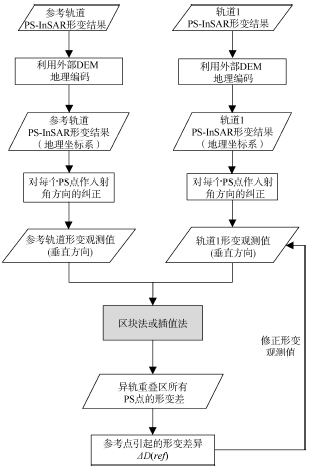
Fig.3 The processing procedure of connecting PS-InSAR subsidence velocities from adjacent tracks.图3 相邻轨道PS-InSAR沉降速率拼接处理流程图 |
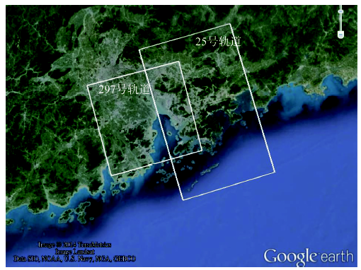
Fig.4 The coverage of research area图4 研究区域覆盖范围示意图 |
Fig.5 Temporal and perpendicular baseline distribution of ENVISAT ASAR images from track 297 and track 25.图5 297号轨道与25号轨道的ENVISAT ASAR数据时间分布与时空基线分布图 |
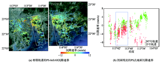
Fig.6 PS-InSAR subsidence velocities from adjacent tracks图6 相邻轨道的PS-InSAR沉降速率 |
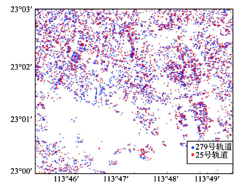
Fig.7 Distribution of PS from track 297 and track 25 (subset of overlapped area).图7 297轨道和25轨道PS点位置分布图(重叠区子区域) |
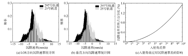
Fig.8 Statistics of subsidence velocities from two adjacent tracks and the impact of incidence difference on subsidence velocity difference.图8 重叠区域沉降速率统计图以及入射角效应对沉降速率差的影响 |
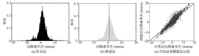
Fig.9 Comparison between Block Method and Interpolation Method.图9 区块法和插值法比较 |
Tab.1 Statistical analysis of two methods: Block Method and Interpolation Method(mm)表1 重叠区沉降速率差的统计分析(mm) |
| 方法 | 方向 | 均值 | 众数 | 最小值 | 最大值 | 标准差 |
|---|---|---|---|---|---|---|
| 区块法 | LOS方向 | 1.163 | 2.433 | -15.474 | 17.807 | 2.884 |
| 垂直方向 | 1.269 | 2.655 | -16.481 | 19.014 | 3.089 | |
| 插值法 | LOS方向 | 1.168 | 2.133 | -16.067 | 15.612 | 3.091 |
| 垂直方向 | 1.275 | 1.065 | -17.118 | 16.771 | 3.318 |
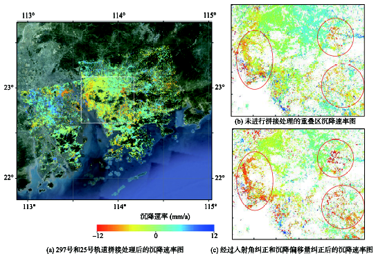
Fig.10 Subsidence velocity maps before and after the connection of track 297 and track 25图10 297号和25号轨道拼接处理前后的沉降速率图 |
The authors have declared that no competing interests exist.
| [1] |
|
| [2] |
|
| [3] |
|
| [4] |
|
| [5] |
|
| [6] |
|
| [7] |
|
| [8] |
|
| [9] |
|
| [10] |
|
| [11] |
|
| [12] |
|
| [13] |
|
| [14] |
|
| [15] |
|
| [16] |
|
/
| 〈 |
|
〉 |
