
Journal of Geo-information Science >
Comparison of the Accuracy between SRTM and ASTER GDEM over Typical Mountain Area: A Case Study in the Eastern Qinghai-Tibetan Plateau
Received date: 2014-02-27
Request revised date: 2014-04-09
Online published: 2015-01-05
Copyright
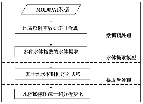
Digital elevation model (DEM) is one of the most important data format for geography research in mountainous areas. At present, the widely used digital elevation models include SRTM and ASTER GDEM. However, their relevant errors are not well distributed under the influence of different terrain types. For the accuracy analysis of these two types of data, this paper considers the 1:50 000 DEM and rivers as references to carry out experiments over the eastern Tibetan Plateau. The horizontal accuracy and vertical accuracy are evaluated respectively by using "river-ravine" deviation method and root mean square error method. The conclusions are drawn from this study as follows: (1) the average river-ravine deviation of SRTM3 is 127.8 m, of which the offset direction is southwest; while that of ASTER GDEM is 104.1 m, of which the offset direction is west; (2) absolute error distribution of SRTM3 is relatively concentrated, where the elevation error is 35.3 m, which is less than ASTER GDEM elevation error of 50.2 m. The overall vertical accuracy of SRTER3 is better than ASTER GDEM; (3) at high altitudes over the average elevation of 4500 m, there is a positive correlation between the error and the elevation, in which the SRTM3 error shows slower growth and higher vertical accuracy compared with ASTER GDEM; (4) the vertical accuracy of the two types obviously depends on the slope, with which the error approximately indicates an exponential curve growth, and the error of SRTM3 in the flat area is less than that of ASTER GDEM. This study helps to understand the error distribution of the two data sets in mountain areas as well as to provide a foundation for further studies in data selection and error correction.
Key words: SRTM3; ASTER GDEM; accuracy
NAN Xi , LI Ainong , BIAN Jinhu , ZHANG Zhengjian . Comparison of the Accuracy between SRTM and ASTER GDEM over Typical Mountain Area: A Case Study in the Eastern Qinghai-Tibetan Plateau[J]. Journal of Geo-information Science, 2015 , 17(1) : 91 -98 . DOI: 10.3724/SP.J.1047.2015.00091
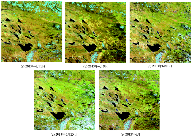
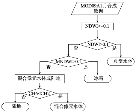
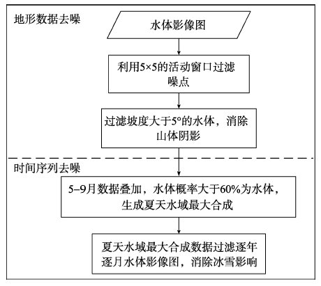
Fig. 1 Case study area and data sets图1 实验区与数据 |
Fig. 2 Overlap-add of river lines with ravine lines extracted from DEMs图2 地形数据提取的山谷线与河流叠合 |
Fig. 3 Fractal polygons made up with river lines and ravine lines图3 河流线与山谷线围成的细碎多边形 |
Fig. 4 Altitude value differences图4 ASTER GDEM、SRTM3与DEM5高程值差 |
Tab. 1 Deviations from river line表1 相对于河流的偏移值 |
| DEM5 | SRTM3 | GDEM | |
|---|---|---|---|
| 总体偏移Δ (m) | 46.5 | 127.8 | 104.1 |
Fig. 5 The offset value changes along with the flow direction图5 偏移值随流向变化情况 |
Fig. 6 Absolute error distributions of SRTM3 and ASTER GDEM图6 SRTM3与ASTER GDEM相对于DEM5误差分布 |
Tab. 2 Error statistics of the sample表2 误差统计 |
| 数据样本 | 高程均值(m) | 绝对误差均值(m) | 绝对误差<20 m的像元比例(%) | RMSE(m) |
|---|---|---|---|---|
| SRTM3 | 2834 | 31.7 | 34.3 | 35.3 |
| ASTER GDEM | 2813 | 42.3 | 24.0 | 50.2 |
Fig. 7 Distribution of RMSE with respect to the elevation and the slope图7 中误差随高程与坡度的变化 |
The authors have declared that no competing interests exist.
| [1] |
|
| [2] |
|
| [3] |
|
| [4] |
|
| [5] |
|
| [6] |
|
| [7] |
|
| [8] |
GISAT. ASTER GDEM Readme File [EB/OL]. 2009.
|
| [9] |
|
| [10] |
|
| [11] |
|
| [12] |
|
| [13] |
|
| [14] |
|
| [15] |
|
| [16] |
|
| [17] |
|
| [18] |
|
| [19] |
|
| [20] |
|
/
| 〈 |
|
〉 |