
Journal of Geo-information Science >
Study on Generation Technique of High Quality Contour Lines Based on Grid DEM
Received date: 2014-06-19
Request revised date: 2014-08-14
Online published: 2015-02-10
Copyright
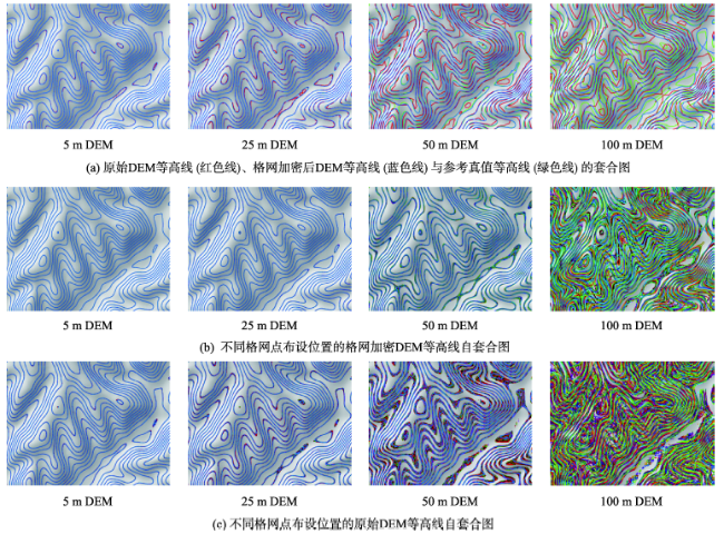
DEM-based generation of high quality contours with properties of convexity, smoothness and flatness has gradually become a key research area for creating contour maps. The existing generation methods have some deficiencies including hardness, intersection and abnormal closure of contours generated in the terrain change areas, such as channels and ridges. In view of the above-mentioned facts, taking a 1:50 000 DEM in the loess hilly region as the test data set, this paper analyzes the basic conditions of reconstruction contours based on densified DEM grid with high quality and efficiency, and examines the accuracy of different interpolation approaches in the process of this reconstruction. Utilizing the comparative analysis, this paper proposes a novel method to generate and represent contours with high quality based on densified DEM grid scheme and terrain shading technique. Experiment results show that: (1) the interpolation approaches include bilinear function, cubic convolution, local quadratic polynomial, and completely regularized spline function. In view of the extreme values, the discrete degree, and the spatial distribution of elevation numerical error, regularized spline function is the optimal interpolation method to reconstruct surface morphology, followed by local quadratic polynomial, cubic convolution, and bilinear interpolation. (2) The contours, which are generated by densified DEM grid via the complete regularized spline function with taking 4×4 DEM grid cells as a search circle, are more accurate and smoother. In the above process, the resolution of densified DEM grid is the actual distance of 0.1mm in the visualized maps. (3) For the terrain with a known generalization scale, there exists an optimal resolution threshold for the DEM. To reproduce the original contours with high quality, the corresponding resolution of DEM cannot be lower than the optimal threshold. (4) The superposition technique between contours and DEM hillshadings attached with a white mask could effectively enhance the three-dimensional effect of contour maps and hence make high quality contour maps incorporating scalability and imaginability.
WANG Chun , LI Hu , YANG Junsheng , YANG Cancan . Study on Generation Technique of High Quality Contour Lines Based on Grid DEM[J]. Journal of Geo-information Science, 2015 , 17(2) : 160 -165 . DOI: 10.3724/SP.J.1047.2015.00160
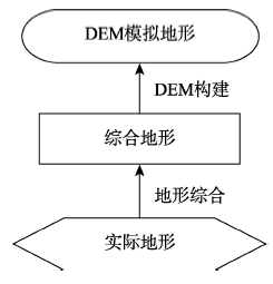
Fig. 1 Logic relation of DEM terrain objects图1 DEM 地形对象逻辑关系图 |
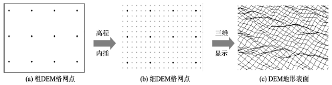
Fig. 2 The reconstruction process of surface reconstruction based on DEM grid-fractionizing scheme图2 基于格网加密技术的DEM地表形态重构过程示意图 |
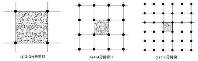
Fig. 3 The search circle (analysis window) of interpolation function during the process of DEM grid densification图3 DEM格网加密过程中内插函数搜索圆(分析窗口)示意图 |
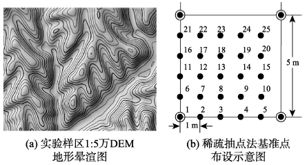
Fig. 4 The schematic diagram of test area图4 实验样区示意图 |
Fig. 5 DEM contour set of graph for different grid resolution and dot location in a 1:5 million visualization map图5 1:5万可视化图中不同格网分辨率及格网点布设位置DEM的等高线套合图 |
The authors have declared that no competing interests exist.
| [1] |
|
| [2] |
|
| [3] |
|
| [4] |
|
| [5] |
|
| [6] |
|
| [7] |
|
| [8] |
|
| [9] |
|
| [10] |
|
| [11] |
|
| [12] |
|
| [13] |
|
| [14] |
|
| [15] |
|
| [16] |
|
| [17] |
|
| [18] |
|
| [19] |
|
| [20] |
|
| [21] |
|
| [22] |
|
/
| 〈 |
|
〉 |