
Journal of Geo-information Science >
A New Attempt of Spatial Governance from the Perspective of GeoDesign: The Application of Integrated Geographical Unit in Zhangjiajie
Received date: 2014-06-20
Request revised date: 2014-10-09
Online published: 2015-03-10
Copyright
GeoDesign leads the technological innovation at the frontier of traditional urban and rural planning. Spatial governance is an important part of urban and rural planning. Facing the difficulties regarding geographical environment, governance and other elements, it is necessary to introduce GeoDesign to formulate rational planning strategies. Under the review of literatures on spatial governance from domestic and overseas research, we firstly define “the integrated geographical unit” as the core concept of this paper. By elaborating its relationship with other relevant concepts, such as ecological function zoning and ecological units, this paper expounds the inherent connection between the integrated geographical unit and GeoDesign. Then, we analyze the dilemmas that traditional spatial planning strategy faces, and indicate the necessity of introducing the concept of integrated geographical unit. Taking this new concept as the basic carrier of spatial governance, this paper systematically formulates the key framework. It explains the division of integrated geographical units, the unitization of governance elements, and the establishment of spatial governance system. Finally, the framework is applied to the urban-rural comprehensive planning of Zhangjiajie city, and is served as an effective planning tool. In this project, the existing ecological factors on both regional and local scales are evaluated and mapped. The whole Zhangjiajie city is divided into 607 integrated geographical units according to the terrain, administrative boundary, boundary of protected areas and the evaluation of ecological importance. Finally, the retrieval tables of information and regulation strategies are established in order to manage all units. To conclude, this framework clearly demonstrates its supporting role in providing the guidelines for functional structure, industrial development, population management and transportation infrastructure construction.
Key words: GeoDesign; spatial governance; integrated geographical unit
MA Qiwei , LIU Xi . A New Attempt of Spatial Governance from the Perspective of GeoDesign: The Application of Integrated Geographical Unit in Zhangjiajie[J]. Journal of Geo-information Science, 2015 , 17(3) : 281 -289 . DOI: 10.3724/SP.J.1047.2015.00281
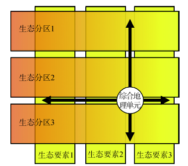
Fig. 1 Integrated geographical unit is an integration of itemizing and zoning图1 综合地理单元是“分条”与“分区”思路的综合 |
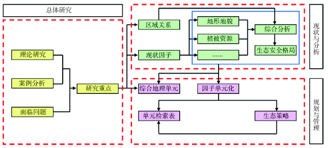
Fig. 2 The technical approach of spatial regulation planning of Zhangjiajie city图2 张家界市空间管制规划的技术路线图 |
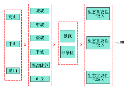
Fig. 3 Naming rule of integrated geographical unit图3 综合地理单元的命名规则 |
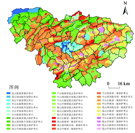
Fig. 4 Zoning map of integrated geographical unit of Zhangjiajie city图4 市域综合地理单元划分图 |
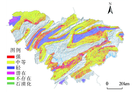
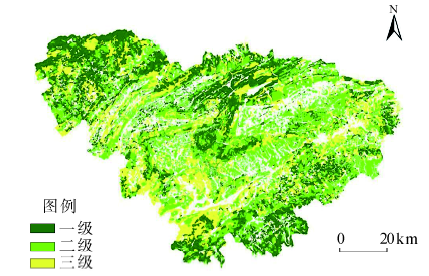
Fig. 5 Analysis graph of stony desertification intensity before zoning图5 单元化前的石漠化强度分析图 |
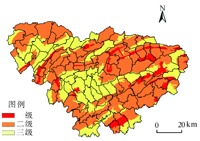
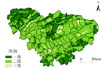
Fig. 6 Analysis graph of stony desertification intensity after zoning图6 单元化后的石漠化强度分析图 |
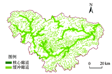
Fig. 7 Analysis graph of river corridors before zoning图7 单元化前的河流廊道分析图 |
Fig. 8 Analysis graph of river corridors after zoning图8 单元化后的河流廊道分析图 |
Fig. 9 Analysis graph of importance of vegetation before zoning图9 单元化前的植被重要性分析图 |
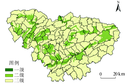
Fig. 10 Analysis graph of importance of vegetation after zoning图10 单元化后的植被重要性分析图 |
Tab. 1 Retrieval table of integrated geographical unit information (an excerpt)表1 综合地理单元信息检索表(节选) |
| 单元编号 | 基本信息 | 生态要素及管制级别 | ||||||||||
|---|---|---|---|---|---|---|---|---|---|---|---|---|
| 单元类别 | 所属乡镇 | 单元面积(km2) | 地质灾害管制级别 | 植被管制级别 | 珍稀生物生境管制级别 | 河流廊道管制级别 | 石漠化管制级别 | 水源涵养地管制级别 | 林场管制级别 | 景区管制级别 | 关键生态地区管制级别 | |
| 1-1-1 | 中山深沟陡谷型一般保护单元 | 桥头 | 14.17 | 2 | 2 | 1 | 1 | 1 | 1 | 1 | 1 | 1 |
| 1-1-2 | 中山丘陵型一般保护单元 | 桥头 | 35.06 | 2 | 2 | 1 | 2 | 1 | 1 | 1 | 1 | 1 |
| 1-1-3 | 中山深沟陡谷型一般保护单元 | 桥头 | 6.32 | 2 | 2 | 1 | 1 | 1 | 1 | 1 | 1 | 1 |
Tab. 2 Retrieval table of regulation strategies (water conservation part)表2 管制策略检索表(水源涵养地部分) |
| 管制级别 | 总体策略 | 植被保护 | 工业控制 | 农业控制 | 建设控制 |
|---|---|---|---|---|---|
| 1 | 将水源保护作为核心职能之一,突出环境保护 | 制订水源涵养林规划,严格划定涵养林范围,尤其加强河流水系两侧廊道内的植被保护 | 禁止各类工业布局 | 控制、缩减农业生产规模,原则上不得使用农药和化肥 | 严格控制各类建设,生活污水必须经由污水处理设施的处理,达到环境标准后方可排放 |
| 2 | 从大流域角度出发,控制区内的各项开发建设。 | 加强植树造林,提高区内植被覆盖率,保护河流水系绿带 | 禁止布局可能对水环境形成影响的工业,现有污染工业限期迁出,加强水环境治理 | 控制耕地面积,推行无农药、无化肥的清洁农业,防止农业面污染出现 | 完善污水设施和城镇排水系统,限期实现污水处理达标和全覆盖 |
| 3 | 以建设控制、环境治理、设施完善为主 | 保护植被资源,保护并完善河流廊道 | 禁止布局对水环境影响较大的工业,工业企业加强污水治理。科学规划畜禽饲养区域和周边旅游业,规模化畜禽养殖场、度假村、旅游宾馆饭店等必须安装污水处理设施 | 推行绿色农业、清洁农业,减少化学物的使用 | 逐步完善污水处理设施,污水处理率达到国际风景旅游城市标准 |
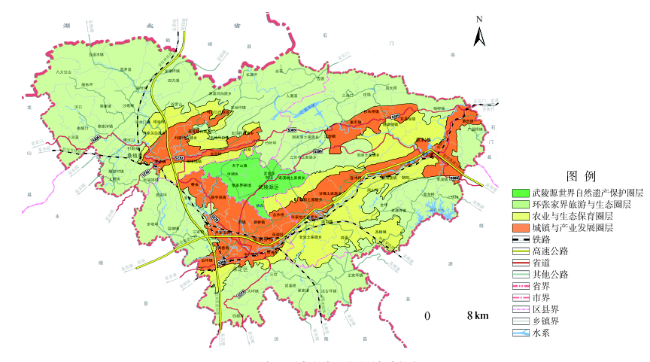
Fig. 11 Concentric zone structure of urban-rural development图11 城乡发展圈层规划图 |
The authors have declared that no competing interests exist.
| [1] |
|
| [2] |
|
| [3] |
|
| [4] |
北京大学第十一届景观设计学教育大会暨2013年地理设计国际会议专题[EB/OL].
|
| [5] |
|
| [6] |
|
| [7] |
|
| [8] |
|
| [9] |
|
| [10] |
|
| [11] |
|
| [12] |
|
| [13] |
|
| [14] |
|
| [15] |
|
| [16] |
|
| [17] |
|
| [18] |
|
| [19] |
|
| [20] |
|
/
| 〈 |
|
〉 |