
Journal of Geo-information Science >
Urban Building Heights Estimation from the Shadow Information on ZY-3 Images
Received date: 2014-07-18
Request revised date: 2014-09-16
Online published: 2015-02-10
Copyright
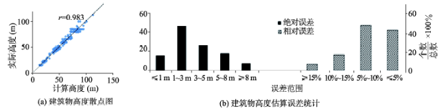
The paper is based on the images of Chinese No. 3 Resource Satellite (ZY-3), the first civil high-resolution surveying and mapping satellite. A method combined with object-oriented approach and morphology ideas is developed in this paper, which not only extracted the information of buildings and shadows from the test sites (Fangzhuang Community in Beijing and the software park in Xiamen) successfully, but also estimated the shadow lengths automatically. Morphological Building Index(MBI) and Morphological Shadow Index(MSI) calculated from the merged images are used to extract information from city buildings and shadows. Subsequently, we estimate the building heights based on the lengths of shadows and their geometric relationship with the sun, the satellite and the buildings. Finally, we use field survey data to evaluate the accuracy of extraction and analyze the source of errors. In the example of Fangzhuang Community, the average relative error of the calculated building heights is 7.08%, and more than 80% of the building heights’ relative error is less than 10%. Moreover, 90% of the buildings’ absolute error is less than 6 meters. The relatively large errors mostly occurred on buildings that have low building heights with inconspicuous shadows, and high-rise buildings with overlapped shadows due to the high density of constructions. Meanwhile, the test site in Xiamen showed the reliability and accuracy of the method. 94.3% of the buildings’ absolute error is less than 5 meters, and the correlation coefficient between the actual heights and the estimated heights is around 0.992. Results demonstrate that the proposed method is able to accomplish building extraction and building height estimation effectively from high-resolution images. In addition, the experiment gives a preliminary indication of the Satellite ZY3, about its immense potential in applications on urban information extraction.
Key words: ZY3; building heights; shadow; MBI; MSI; object-oriented
SHI Yifang , WANG Xiaoqin , SUN Zhenhai , CHEN Yunzhi , FU Qiankun . Urban Building Heights Estimation from the Shadow Information on ZY-3 Images[J]. Journal of Geo-information Science, 2015 , 17(2) : 236 -243 . DOI: 10.3724/SP.J.1047.2015.00236
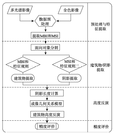
Fig. 1 Technology flowchart of estimation of building heights from shadow by remote sensing data图1 基于阴影的建筑物高度遥感估算流程 |
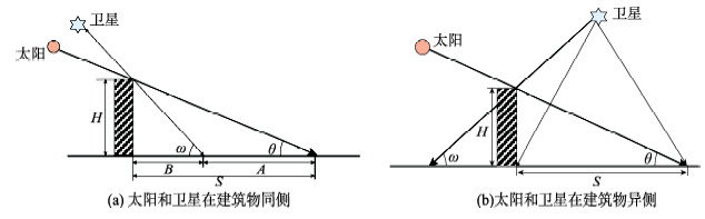
Fig. 2 The relationship between solar altitude and the shadow of building图2 太阳高度角和建筑物阴影的关系 |
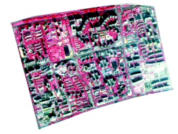
Fig. 3 Merged image of the test site (constitute by band 4,3 and 2)图3 北京方庄小区融合影像(4、3、2波段组合) |
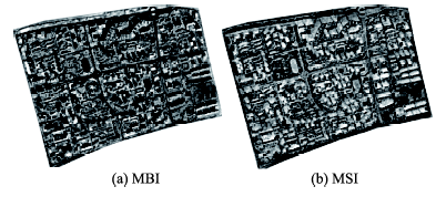
Fig. 4 The feature images of MBI and MSI图4 MBI和MSI特征影像 |
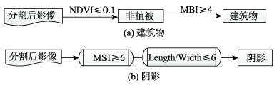
Fig. 5 The rules for building and shadow detection图5 建筑物及阴影提取知识规则 |
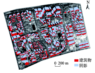
Fig. 6 The result of building and shadow information extraction图6 方庄小区建筑物和阴影信息提取结果 |
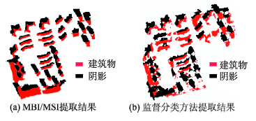
Fig. 7 The comparison of extraction results between MBI/MSI and supervised classification图7 MBI/MSI与监督分类方法提取结果对比 |
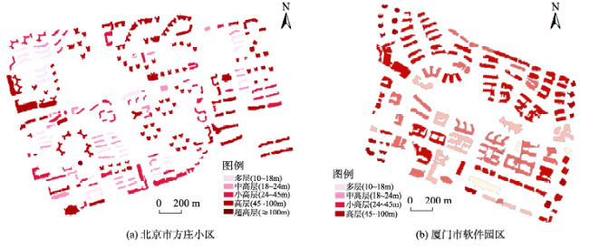
Fig. 8 The distribution of estimated building heights in the test sites图8 研究区建筑物估算高度分布 |
Fig. 9 The scatter diagram and error statistics of building heights at Fangzhuang site in Beijing图9 北京方庄建筑物高度散点图及误差统计 |
Tab. 1 The error statistics of building heights at Fangzhuang site表1 方庄小区建筑物高度估算误差统计 |
| 绝对误差 | 所占百分比(%) | 相对误差 | 所占百分比(%) |
|---|---|---|---|
| < 3 m | 40.4 | < 5% | 37.9 |
| 3 m ≤< 5 m | 37.4 | 5% ≤< 10% | 42.4 |
| 5 m ≤< 8 m | 15.8 | 10% ≤< 15% | 14.3 |
| ≥ 8 m | 6.4 | ≥ 15% | 5.4 |
| 建筑物高度范围(m) | 绝对误差<6 m的建筑物百分比(%) | 相对误差<10%的建筑物百分比(%) | |
| 10~30 | 100 | 62.5 | |
| 30~70 | 91.6 | 84.2 | |
| 70~130 | 68.1 | 84.1 | |
The authors have declared that no competing interests exist.
| [1] |
|
| [2] |
|
| [3] |
|
| [4] |
|
| [5] |
|
| [6] |
|
| [7] |
|
| [8] |
|
| [9] |
|
| [10] |
|
| [11] |
|
| [12] |
|
| [13] |
|
| [14] |
|
| [15] |
|
| [16] |
|
| [17] |
|
| [18] |
|
| [19] |
|
| [20] |
|
| [21] |
|
/
| 〈 |
|
〉 |