
Journal of Geo-information Science >
Vector Data Compression of Frequency Domain Based on Tolerance of Average Error
Received date: 2015-01-14
Request revised date: 2015-02-19
Online published: 2015-08-05
Copyright
With the constant enhancement of data acquisition capability, an increasing amount of spatial data is available to WebGIS. However, the efficiency of spatial data transmission cannot meet the current need for fast access to spatial data. In such a context, the compression of spatial data is important for reducing the space of data storage and improving the efficiency of data transmission and processing for WebGIS. Traditional methods of vector data compression are usually based on spatial relations, such as the distances or angles between different vertices, to determine which vertices are redundant. Whereas in the field of image compression, the method based on the techniques of transform coding (in frequency domain) is more frequently-used. This paper proposes a novel method of spatial vector data compression in frequency domain. This method is composed of several steps. To be specific, we transform the coordinate values of x and y to frequency domain coefficients respectively using Discrete Cosine Transform (DCT), and quantize these coefficients according to the relevant specific thresholds, which could restrict the average distortions (root-mean-square error, RMSE) of the reconstructed vector data. This quantizing method does not need quantization tables and is adaptive to large thresholds that often cause problems such as compressing a polygon or line feature into a point or a polygon feature into a line. In the final stage of the proposed vector data compression method, the Huffman coding is used in a similar way to the corresponding part of JPEG standard. The proposed compression method was implemented by C#.NET and was applied to compress vector data to test its performance from the aspects of compression ratio and geometric shape distortion. The results of the tests show that the proposed method is a feasible solution for vector data compression. It is flexible in terms of restricting distortion, and it can achieve large compression ratios as well as retain the main geographic shape´s characteristics which are derived from the original vector data, within the compressed vector data.
Key words: vector data map; WebGIS; DCT; average error; spatial data compression
HUANG Weiming , YANG Jianyu , YUE Yanli , DU Meng , ZHANG Chao , ZHU Dehai . Vector Data Compression of Frequency Domain Based on Tolerance of Average Error[J]. Journal of Geo-information Science, 2015 , 17(8) : 883 -888 . DOI: 10.3724/SP.J.1047.2015.00883
Tab. 1 Compression performance (compressed storage space and time efficiency) in respect to the size of block表1 使用不同的分块大小进行算法的性能测试(包含算法运行时间和压缩比) |
| 性能参数 | 分块大小N | ||||
|---|---|---|---|---|---|
| 16 | 32 | 64 | 128 | 256 | |
| 压缩所用时间(ms) | 682 | 947 | 1417 | 2089 | 3020 |
| 压缩后大小(KB) | 382 | 378 | 372 | 370 | 369 |
Tab. 2 Compression performance (compression ratio and compression bias) of our method (from the first test featureclass)表2 本文方法在不同平均误差限值下的性能参数(实验数据为部分北京市通州区矢量等高线图) |
| 性能参数 | 平均误差限值(m) | ||||
|---|---|---|---|---|---|
| 1 | 2 | 5 | 8 | 10 | |
| RMSE(m) | 0.96 | 1.94 | 4.83 | 7.64 | 9.47 |
| 最大误差(m) | 4.85 | 10.93 | 28.28 | 58.49 | 80.50 |
| 压缩后大小(KB) | 594 | 372 | 269 | 212 | 188 |
| 压缩比(%) | 86.3 | 91.4 | 93.8 | 95.1 | 95.7 |
Tab. 3 Compression performance (compression ratio and compression bias) of our method (from the second test featureclass)表3 本文方法在不同平均误差限值下的性能参数(实验数据为美国爱达荷州的矢量边界图) |
| 性能参数 | 平均误差限值(m) | ||||
|---|---|---|---|---|---|
| 10 | 20 | 30 | 50 | 80 | |
| RMSE(m) | 9.99 | 20.00 | 29.99 | 49.99 | 79.97 |
| 最大误差(m) | 35.73 | 64.50 | 103.36 | 190.22 | 442.31 |
| 压缩后大小(KB) | 19 | 16 | 14 | 11 | 9 |
| 压缩比(%) | 83.0 | 85.7 | 87.5 | 90.2 | 92.0 |
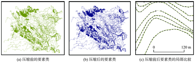
Fig. 1 The comparison of the original map and compressed map at global and local scales (for the first test featureclass)图1 部分北京市通州区矢量等高线图压缩前后全局和局部比较 |
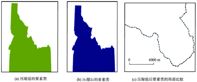
Fig. 2 The comparison of the original map and compressed map at global and local scales (for the second test featureclass)图2 美国爱达荷州的矢量边界图压缩前后全局和局部比较 |
The authors have declared that no competing interests exist.
| [1] |
|
| [2] |
|
| [3] |
|
| [4] |
|
| [5] |
|
| [6] |
|
| [7] |
|
| [8] |
|
| [9] |
|
| [10] |
|
| [11] |
|
| [12] |
|
| [13] |
|
| [14] |
|
| [15] |
|
| [16] |
|
| [17] |
|
| [18] |
|
| [19] |
|
| [20] |
|
| [21] |
|
| [22] |
|
/
| 〈 |
|
〉 |