
Journal of Geo-information Science >
Analysis of the Distribution of Prehistoric Settlement Sites in Zhengluo Region Based on the Area of Drainage Basins
Received date: 2014-10-30
Request revised date: 2015-03-17
Online published: 2015-09-07
Copyright
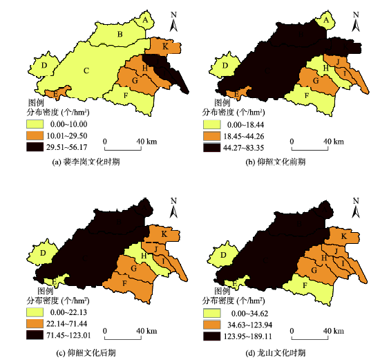
Hydrological analysis module supported by GIS extracts information about the hydrological characteristics of research area by using Digital Elevation Model. In this paper, Zhengzhou-Luoyang region is selected as the research area. And Peiligang cultural period, early Yangshao cultural period, later Yangshao cultural period and Longshan cultural period are selected as the time series. The paper uses hydrological analysis to get the information of drainage basins in Zhengluo region, which is proved to be viable and rarely used in previous researches about the relationship between prehistoric settlement sites and drainage basins. According to the information of drainage basins, this paper analyzes its relationship with the spatial distribution of settlement sites in Zhengluo region. Besides, the relationship between the area of the drainage basin and the growth rate of its settlement sites, and the relationship between the area of the drainage basin and the number of its settlement sites are studied in the paper. The above relationships are clearly displayed in a digital way using the correlation analysis. And the results suggest that there is a significant positive correlation between the area of drainage basins and the number of settlement sites. There is also a positive correlation between the area of drainage basins and the change trend of settlement sites. When studying the characteristics of spatial and temporal distribution of settlement sites in each drainage basin, it can be found that during Peiligang cultural period, the distribution density of settlement sites in the eastern region is greater than the western region. And among the other three cultural periods, the distribution density of settlement sites in the central and western region is greater than the eastern region. Due to the different modes of production, there is a great difference among the residential environment within which the settlement sites are located. As time goes on, people′s dependence on drainage basins is gradually decreasing with the change of the modes of production. Therefore, the research on the relationship between prehistoric settlement sites and drainage basins extracted using the hydrological analysis is highly significant.
SHEN Xiang , BI Shuoben , JI Han , YANG Hongru , CHEN Changchun . Analysis of the Distribution of Prehistoric Settlement Sites in Zhengluo Region Based on the Area of Drainage Basins[J]. Journal of Geo-information Science, 2015 , 17(9) : 1062 -1071 . DOI: 10.3724/SP.J.1047.2015.01063
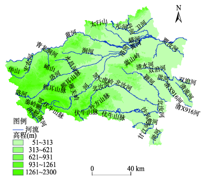
Fig.1 Overlay graph of topography, mountains and rivers in Zhengzhou-Luoyang district图1 郑洛地区地形、山脉和水系的叠加图 |
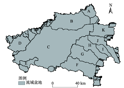
Fig. 2 Drainage basins obtained by hydrology analysis in Zhengzhou-Luoyang district图2 通过水文分析得到的郑洛地区流域盆地图 |
Tab. 1 The brief distribution of drainage basins in Zhengzhou-Luoyang district表1 郑洛地区流域盆地简介表 |
| 流域盆地编号 | 流域名称 | 流域盆地中包含的主要河流 |
|---|---|---|
| A | 卫河流域 | 卫河 |
| B | 黄河流域 | 黄河 |
| C | 伊洛河流域 | 伊洛河、伊河、洛河 |
| D | 宏农河流域 | 宏农河、西涧河 |
| E | 老灌河流域 | 老灌河 |
| F | 沙河流域 | 沙河 |
| G | 汝河流域 | 汝河 |
| H | 颍河流域 | 颍河 |
| I | 小洪河流域 | 小洪河 |
| J | 双洎河流域 | 清流河、双洎河 |
| K | 贾鲁河流域 | 贾鲁河 |
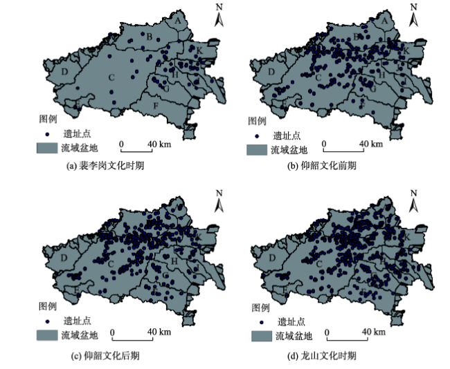
Fig. 3 The composite map of settlement sites and drainage basins in Zhengzhou-Luoyang district图3 郑洛地区流域盆地与遗址点复合图 |
Tab. 2 Correlation analysis between drainage basins among four cultural periods and the number of settlement sites in Zhengzhou-Luoyang district表2 郑洛地区4个文化时期流域盆地与遗址点数量的相关性分析结果表 |
| 文化时期 | 相关系数 | Sig.(2-tailed) |
|---|---|---|
| 裴李岗文化时期 | 0.712* | 0.014 |
| 仰韶文化前期 | 0.983** | 0.000 |
| 仰韶文化后期 | 0.983** | 0.000 |
| 龙山文化时期 | 0.973** | 0.000 |
注:*表示在0.05(双侧)水平上显著相关;**表示在0.01(双侧)水平上显著相关;Sig表示(2-tailed):双侧显著性 |
Tab. 3 The statistical table of the number of settlement sites and their change trend in each drainage basin表3 郑洛地区各流域盆地的遗址点数量与变化趋势统计表 |
| 流域盆地编号 | 裴李岗文化时期 | 仰韶文化前期 | 仰韶文化后期 | 龙山文化时期 | 趋势线公式系数 |
|---|---|---|---|---|---|
| A | 0 | 1 | 9 | 18 | 6.2 |
| B | 5 | 31 | 67 | 103 | 33.0 |
| C | 18 | 150 | 201 | 252 | 75.3 |
| D | 0 | 0 | 0 | 0 | 0.0 |
| E | 2 | 2 | 1 | 1 | -0.4 |
| F | 0 | 4 | 13 | 14 | 5.1 |
| G | 10 | 15 | 15 | 33 | 6.9 |
| H | 7 | 5 | 6 | 31 | 7.3 |
| I | 4 | 3 | 3 | 11 | 2.1 |
| J | 13 | 5 | 11 | 16 | 1.5 |
| K | 5 | 16 | 17 | 18 | 4.0 |
Tab. 4 The result of correlation analysis between the coefficients of trend line equations and the area of drainage basins表4 趋势线公式系数与流域盆地面积的相关性分析结果 |
| 相关系数 | Sig.(2-tailed) |
|---|---|
| 0.967** | 0.000 |
注:**表示在0.01(双侧)水平上显著相关 |
Fig. 4 Spatial distribution of the density of settlement sites of selected drainage basins in Zhengzhou-Luoyang district图4 郑洛地区提取的流域盆地中遗址点分布密度的空间分布图 |
The authors have declared that no competing interests exist.
| [1] |
|
| [2] |
|
| [3] |
|
| [4] |
|
| [5] |
|
| [6] |
|
| [7] |
|
| [8] |
|
| [9] |
|
| [10] |
|
| [11] |
|
| [12] |
|
| [13] |
|
| [14] |
|
| [15] |
|
| [16] |
|
| [17] |
|
| [18] |
|
| [19] |
|
| [20] |
|
| [21] |
|
/
| 〈 |
|
〉 |