
Journal of Geo-information Science >
Review on Remote Sensing Retrieval of Water Surface Temperature
Received date: 2014-09-19
Request revised date: 2014-12-11
Online published: 2015-08-05
Copyright
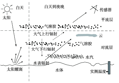
Water surface temperature (including sea surface temperature and lake water surface temperature) is a key parameter for studying global or regional climate change and numerical weather prediction (NWP), as well as being an essential controlling variable in the exchange of heat, moisture and gases between water surface and atmosphere. It has important significance for understanding the biophysical processes of water body. Satellite measurements of water surface temperature are well established with 30 years' collection of practical data and have incomparable advantages over traditional observations. Their limitations and challenges are also identified at the same time. There are more than 30 types of infrared/microwave radiometers which can be used for measuring SST/LWST, and their resolutions, advantages and disadvantages are summarized and compared in this paper. SST/LWST measurements depend on a combination of atmospheric properties and water surface radiances. Therefore, it is necessary to adjust and correct the atmospheric effect and water surface processes. The basic principles and the main types of algorithms for water surface temperature inversion using infrared and microwave data are illuminated and reviewed briefly. There are many uncertainties associated with SST/LWST measurements, and the magnitude of these uncertainties has put restrictions on the application or interpretation of SST/LWST measurements. A detailed analysis about these uncertainties in both infrared and microwave SST/LWST retrieval including undetected cloud, water vapor, aerosols, emissivity and skin effect is conducted. In order to determine the uncertainties in satellite-derived surface temperature, the validation of surface temperature retrieval is an indispensable step. Finally, a prospection about the trend of water surface temperature retrieval is proposed. Additionally, a strategy is advised for assimilating measurements from multi-sensor data in order to take the advantage of their complementary strengths.
YAN Fuli , WU Liang , WANG Shixin , ZHOU Yi , XU Chenna , WANG Lishuang . Review on Remote Sensing Retrieval of Water Surface Temperature[J]. Journal of Geo-information Science, 2015 , 17(8) : 969 -978 . DOI: 10.3724/SP.J.1047.2015.00969
Tab. 1 The available remote sensing datasets for water surface temperature retrieval表1 可用于水表温度反演的卫星遥感数据 |
| 类型 | 时间分辨率 | 空间分辨率 | 卫星传感器(传感器英文全称) | 波段 |
|---|---|---|---|---|
| 红外数据 | 1~16 d | 约100 m | Landsat-7-ETM+(Landsat Enhanced Thematic Mapper Plus)Landsat-8-TIRS(Thermal Infrared Sensor)Terra-ASTER(Advanced Spaceborne Thermal Emission and Reflection Radiometer) | ASTER和TIRS有2个或2个以上热红外波段,ETM+只有1个热红外波段;无中红外波段 |
| 1~4 d | 约300 m | HJ-1B-IRS(Infrared Spectrometer)FY-3-MERSI(Medium Resolution Spectral Imager) | 均有1个热红外波段;IRS有1个中红外波段 | |
| 2次/d | 约1 km | NOAA-AVHRR(Advanced Very High Resolution Radiometer)Terra/Aqua-MODIS(Moderate Resolution Imaging Spectroradiometer)NPP-VIIRS(Visible Infrared Imaging Radiometer Suite)FY-3-VIRR(Visible Infrared Radiometer) | 均有2个位于大气窗口的热红外波段,中红外波段数不一 | |
| 1次/3 d | 约1 km | ENVISAT-AATSR(Advanced Along Track Scanning Radiometer)ERS-ASTR-1/2(Along Track Scanning Radiometers 1/2) | 2个热红外,1个中红外波段 | |
| 12~14 km | Aqua-AIRS(Atmospheric Infrared Sounder)Metop-IASI(Infrared Atmospheric Sounding Interferometer) | 2378个红外通道8461个红外通道 | ||
| 0.5~1 h | 3~10 km | FY-2-S-VISSR(Stretched Visible and Infrared Spin Scan Radiometer)Meteosat-SEVIRI(Spinning Enhanced Visible and Infrared Imager)GOES-Imager/ABI(Advanced Baseline Imager) | 2个位于大气窗口的热红外波段,中红外波段数不一 | |
| 微波数据 | 1~2 d | 25~50 km | TRMM-TMI(Microwave Imager)Aqua-AMSR-E(The Advanced Microwave Scanning Radiometer-EOS)FY-3-MWRI(Microwave Radiometer Imager)GCOM-W1-AMSR-2(Advanced Microwave Scanning Radiometer 2) | 有1-3个不等的波段,多个极化通道 |
Tab. 2 The advantages/disadvantages of different satellite datasets for water surface temperature retrieval.表2 不同卫星数据源反演水体表面温度的适用性与优劣 |
| 数据源 | 绝对精度(K) | 空间分辨率 | 适用性 | 优势 | 劣势 |
|---|---|---|---|---|---|
| AVHRR、MODIS、NPP/VIIRS、FY-3/VIRR等数据 | 0.4~0.6 | 0.75~4 km | 适用于海洋及面积较大的湖泊 | 每天观测全球2次;算法成熟、应用广泛;有非常成熟的数据产品 | 观测小尺度水体空间分辨率不够高 |
| ATSR-1/2和AATSR数据 | 0.2~0.3 | 1~2 km | 适用于海洋及面积较大的湖泊 | 更精确地校正大气效应,反演精度高、噪声低 | 扫描宽度较窄;重复观测周期较长(3 d) |
| TM/ETM+、HJ-1B/HRS、TIRS等资源卫星数据 | 约1 | 60~300 m | 适用于内陆湖泊及临近海岸海域 | 空间分辨率高 | 红外波段单一;覆盖面积小;重复观测周期较长 |
| GOES/Imager FY-2/S-VISSR Meteosat-SEVIRI等静止气象卫星数据 | 0.5~0.8 | 3~10 km | 适用于传感器观测区域内的海域 | 重复观测时间间隔短(0.5~1 h),其他数据难以企及的高时间频率 | 空间分辨率不高;受到观测角限制,不能观测全球 |
| 以IASI、AIRS为代表的高光谱数据 | 12~14 km | 适用于大面积海域 | 能提供综合反演,即能够识别云,能够计算大气温度、湿度廓线等大气数据 | 空间分辨率低;处理过程复杂;其主要用于大气廓线反演、云检测等领域 | |
| 以AMSR-E、TMI为代表的微波数据 | 0.5~1 | 25~50 km | 仅适用于大面积且远离陆地海域 | 全天时、全天候、多极化,尤其是能在云覆盖条件下观测SST,保证数据可用性 | 空间分辨率低、反演精度不高;易受陆地辐射的干扰;易受海风影响 |
The authors have declared that no competing interests exist.
| [1] |
|
| [2] |
|
| [3] |
|
| [4] |
|
| [5] |
|
| [6] |
|
| [7] |
|
| [8] |
|
| [9] |
|
| [10] |
|
| [11] |
Committee for Earth Observation Satellites. The Earth Observation Handbook[DB/OL]. 2014-8.
|
| [12] |
|
| [13] |
|
| [14] |
|
| [15] |
|
| [16] |
|
| [17] |
|
| [18] |
|
| [19] |
|
| [20] |
|
| [21] |
|
| [22] |
|
| [23] |
|
| [24] |
|
| [25] |
|
| [26] |
|
| [27] |
|
| [28] |
|
| [29] |
|
| [30] |
|
| [31] |
|
| [32] |
|
| [33] |
|
| [34] |
|
| [35] |
|
| [36] |
|
| [37] |
|
| [38] |
|
| [39] |
|
| [40] |
|
| [41] |
|
| [42] |
|
| [43] |
|
| [44] |
|
| [45] |
|
| [46] |
|
/
| 〈 |
|
〉 |