
Journal of Geo-information Science >
Vegetation Information Extraction of Pinus Massoniana Forest in Soil Erosion Areas Using Soil-adjusted Vegetation Index
Received date: 2015-01-04
Request revised date: 2015-03-11
Online published: 2015-09-07
Copyright
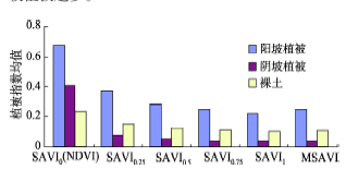
Vegetation indices are frequently used in remote sensing applications. Nevertheless, vegetation monitoring based on vegetation indices may be affected by different soil background conditions. The aim of this study is to investigate the relationships between vegetation abundance and vegetation indices, and evaluate the performance of vegetation indices along with different values for soil-adjusted factors in vegetation-feature extractions. Changting county of Fujian, a typical reddish soil erosion region in southern China, was taken as a test site for the study. Three subtest sites were selected to represent the low, moderate and dense vegetation coverage areas, respectively. After converting the original digital numbers of the ALOS image to at-satellite reflectance, vegetation indices including the normalized difference vegetation index (NDVI), the modified soil-adjusted vegetation index (MSAVI) and the soil-adjusted vegetation index (SAVI) with soil adjustment factor (L) values of 0.25, 0.5, 0.75 and 1 were calculated. The vegetation features were then extracted from the above vegetation-enhanced images and compared to high resolution images to assess their accuracies. The results suggest that SAVI gives a better performance in both low and moderate vegetation coverage area while using a L value of 0.75 for low vegetation coverage area and 0.5 for moderate vegetation coverage area, with the overall accuracies of 76.26% and 80.65%, respectively. NDVI gives a better performance in the dense vegetation coverage area with an overall extraction accuracy of 84.01%. Whereas MSAVI does not perform well in any of the three selected test sites. The soil adjustment factor L of SAVI has significant influence on the accurate extraction of vegetation information. As increasing L from 0 to 1, the ability of the SAVI in detecting sparse vegetation is gradually enhanced, however its ability in detecting vegetation information in shaded slope areas is decreased.
Key words: vegetation extraction; soil adjustment factor; SAVI; NDVI; MSAVI
LI Jing , XU Hanqiu , LI Xia , GUO Yanbin . Vegetation Information Extraction of Pinus Massoniana Forest in Soil Erosion Areas Using Soil-adjusted Vegetation Index[J]. Journal of Geo-information Science, 2015 , 17(9) : 1128 -1134 . DOI: 10.3724/SP.J.1047.2015.01128
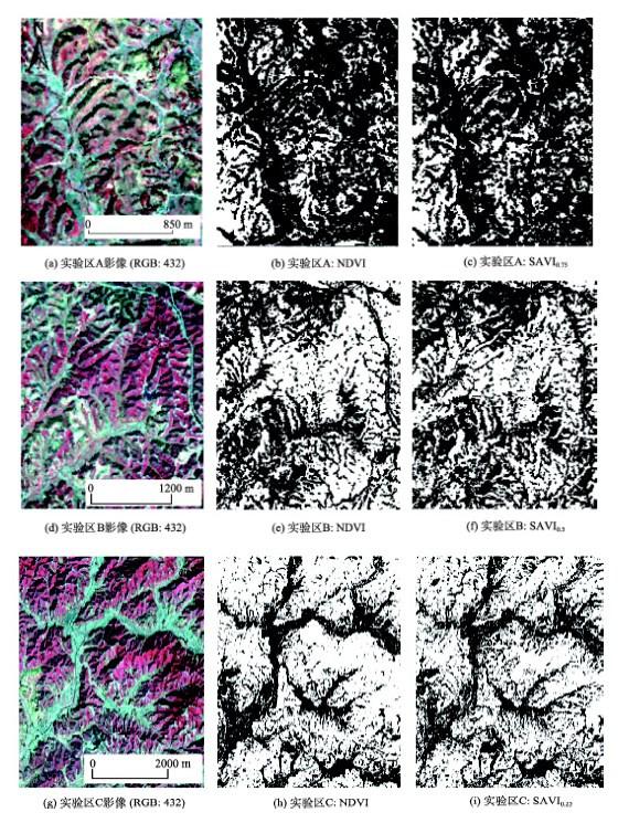
Fig. 1 Vegetation extraction images (white tone represents vegetation area)图1 实验区马尾松林植被提取结果图(白色为植被,黑色为非植被) |
Tab. 1 Accuracy assessment of extracted vegetation information表1 实验区植被提取精度验证 |
| 指数类型及L取值 | 阈值 | 实验区A | 实验区B | 实验区C | |||||
|---|---|---|---|---|---|---|---|---|---|
| 总精度(%) | Kappa | 总精度(%) | Kappa | 总精度(%) | Kappa | ||||
| SAVI0 (NDVI) | 0.38 | 74.43 | 0.4287 | 75.40 | 0.5190 | 84.01 | 0.6531 | ||
| SAVI0.25 | 0.23 | 75.80 | 0.4574 | 77.02 | 0.5457 | 81.50 | 0.6092 | ||
| SAVI0.5 | 0.18 | 75.80 | 0.4574 | 80.65 | 0.6143 | 79.00 | 0.5518 | ||
| SAVI0.75 | 0.16 | 76.26 | 0.4543 | 77.02 | 0.5416 | 74.29 | 0.4698 | ||
| SAVI1 | 0.15 | 74.43 | 0.4081 | 75.81 | 0.5144 | 73.04 | 0.4562 | ||
| MSAVI | 0.16 | 74.16 | 0.4480 | 76.21 | 0.5149 | 79.62 | 0.5785 | ||
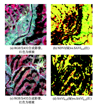
Fig. 2 Comparison of vegetation extraction using different vegetation indices图2 不同植被指数植被提取效果对比图 |
Fig. 3 Vegetation indices of typical features in the test sites图3 植被指数在阴阳坡的均值变化对比 |
The authors have declared that no competing interests exist.
| [1] |
|
| [2] |
|
| [3] |
|
| [4] |
|
| [5] |
|
| [6] |
|
| [7] |
|
| [8] |
|
| [9] |
|
| [10] |
|
| [11] |
|
| [12] |
|
| [13] |
|
| [14] |
|
| [15] |
|
| [16] |
|
| [17] |
|
| [18] |
|
| [19] |
|
| [20] |
|
| [21] |
|
| [22] |
|
| [23] |
|
| [24] |
|
| [25] |
|
| [26] |
|
| [27] |
|
| [28] |
|
| [29] |
|
| [30] |
|
| [31] |
|
/
| 〈 |
|
〉 |