
Journal of Geo-information Science >
Optimizing the Precautionary Areas of Coastal Ships' Routing in Western Taiwan Strait with Statistical Inference Method for Delineating the Boundary of Maritime Principal Fairways
Received date: 2015-05-12
Request revised date: 2015-08-19
Online published: 2015-10-10
Copyright
The Taiwan Strait is a shortcut linking the Far-east with Southeast Asia. After the implementation of direct cross-strait transportation between mainland China and Taiwan on December 12th, 2008, more and more commercial vessels sail across the strait, causing frequent conflicts between involved ships who undertake continuous and expeditious transit passages through the strait. To minimize the possibility of collisions between ships passing the strait, mainland China and Taiwan should work cooperatively to create a ship routing system to separate vessels and navigate the crossing and encountering situations occurred in the strait. Recent advances in ship tracking and telemetry technology help to collect the movement data more efficiently and accurately. The shore-based Automatic Identification System (AIS) network maintained by China Maritime Safety Administration has observed tens of thousands of seagoing commercial ships travelling annually through the Taiwan Strait. It is obvious that the ship tracks have increased tremendously in the strait. These advances would be useful for delineating Principal Fairways (PFs) in the crowded strait-corridor. In this paper, a space-use method found in the habitat evaluation of animal is applied to extract PFs in the crowded strait. Based on ship trajectory observations of the main traffic flows (transit-passage) and direct cross-strait transits, maritime traffic features of the strait are characterized in the form of probability density with the application of statistical inference methods. Bringing the layer of popular direct cross-strait lanes to the iso-surface of main traffic flow's skeleton, all conflict areas are extracted as the Precautionary Areas (PAs) of China's Coastal Ships Routing System Plan in Western Taiwan Strait. For direct cross-strait transportations, by linking the centers of PAs in the Western Taiwan Strait with the official pass points outside the western Taiwan harbors, this paper recommends the applicable direct cross-strait routes to reduce the risk of conflicts in the Taiwan Strait.
CHEN Jinhai , LU Feng , LI Mingxiao . Optimizing the Precautionary Areas of Coastal Ships' Routing in Western Taiwan Strait with Statistical Inference Method for Delineating the Boundary of Maritime Principal Fairways[J]. Journal of Geo-information Science, 2015 , 17(10) : 1196 -1206 . DOI: 10.3724/SP.J.1047.2015.01196
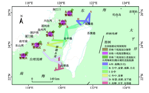
Fig.1 National planning of coastal ships' routing in western Taiwan Strait and the range of cross-strait shipping links in eastern Taiwan Strait图1 台海西侧水域船舶定线制规划及东侧水域海运直航范围 |
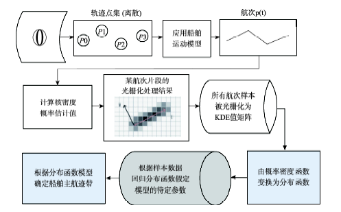
Fig.2 Workflow of statistical inference on vessel trajectories图2 船舶轨迹统计推断方法流程 |
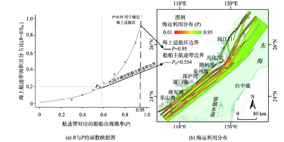
Fig. 3 Extracting Principle Fairway Region by the fitting function图3 利用回归函数确定船舶主航迹带 |
Tab. 1 Regression result of the principal fairways for the main stream of northbound/southbound voyages in Taiwan Strait表1 通行海峡南北航次的船舶主航迹带回归结果 |
| 航次方向 | a区间估算 | b区间估算 | levelD区间估算 | ||||||||
|---|---|---|---|---|---|---|---|---|---|---|---|
| 2.5% | 97.5% | LCE | 2.5% | 97.5% | LCE | 2.50% | 97.50% | LCE | |||
| 南北合计 | 0.074 | 0.079 | 0.076 | 2.757 | 2.822 | 2.789 | 0.577 | 0.532 | 0.554 | ||
| 南下方向 | 0.069 | 0.073 | 0.071 | 2.808 | 2.874 | 2.841 | 0.587 | 0.542 | 0.564 | ||
| 北上方向 | 0.076 | 0.081 | 0.078 | 2.756 | 2.824 | 2.790 | 0.569 | 0.522 | 0.545 | ||
注: LCE(Least Square Estimate)指最小二乘估算值 |
Tab. 2 Regression result of direct cross-strait transits' principal fairways in Taiwan Strait表2 横穿海峡直航航次的船舶主航迹带回归结果 |
| 次方向 | a区间估算 | b区间估算 | levelD区间估算 | ||||||||
|---|---|---|---|---|---|---|---|---|---|---|---|
| 2.5% | 97.5% | LCE | 2.5% | 97.5% | LCE | 2.50% | 97.50% | LCE | |||
| 直航合计 | 0.074 | 0.084 | 0.079 | 2.610 | 2.736 | 2.673 | 0.631 | 0.539 | 0.584 | ||
| 向东往福建沿海 | 0.075 | 0.085 | 0.079 | 2.606 | 2.732 | 0.629 | 0.536 | 0.582 | |||
| 向西往台湾本岛 | 0.070 | 0.080 | 0.075 | 2.668 | 2.646 | 0.636 | 0.539 | 0.586 | |||
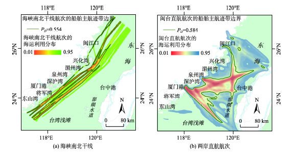
Fig. 4 SUD and PFR in Taiwan Strait: (a) northbound/southbound voyages and (b) direct cross-strait transits图4 海峡南北干线和两岸直航航次的海运利用分布、主航迹带边界示意图 |
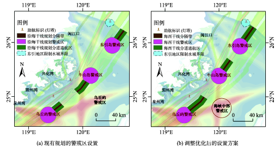
Fig. 5 Original and optimal design of precautionary area in western Taiwan Strait图5 台湾海峡航路警戒区调整前后的对比图 |
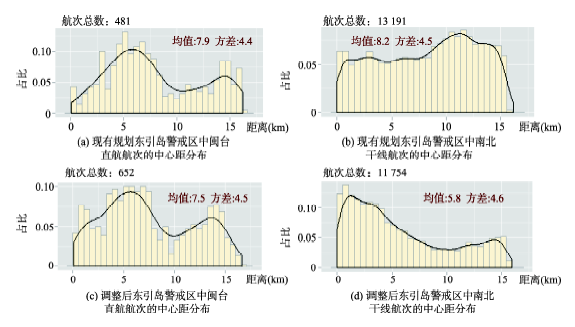
Fig. 6 Distance distribution of transit passages to the center of original and optimal precautionary area of Dongyin图6 东引岛警戒区调整前后两类航次到警戒区中心的距离密度分布 |
Fig. 7 Distance distribution of transit passages to the center of original and optimal precautionary area of Niushan图7 对比牛山岛警戒区调整前后,南北走向、闽台直航航次到警戒区中心的距离密度分布 |
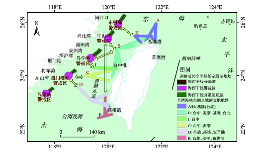
Fig. 8 Recommendation of direct cross-strait route between the precautionary area and passing points图8 台湾海峡警戒区与指定通过点间的直航船推荐航路 |
The authors have declared that no competing interests exist.
| [1] |
|
| [2] |
|
| [3] |
|
| [4] |
|
| [5] |
|
| [6] |
|
| [7] |
|
| [8] |
|
| [9] |
|
| [10] |
|
| [11] |
|
| [12] |
|
| [13] |
|
| [14] |
台湾海军大气海洋局.海军大气海洋局航船布告(第184号):台湾地区与大陆地区海运直航范围通告[R].2008.
|
| [15] |
交通运输部.全国沿海船舶定线制总体规划(交海发[2011]388号)[R].2011.
|
| [16] |
|
| [17] |
|
| [18] |
|
| [19] |
|
| [20] |
|
| [21] |
|
| [22] |
|
| [23] |
|
| [24] |
|
| [25] |
|
| [26] |
EQUASIS. IMO unique Company and Registered Owner identification number access on the free public website of EQUASIS [Z].2014.
|
| [27] |
|
/
| 〈 |
|
〉 |
