
Journal of Geo-information Science >
Airborne Hyperspectral Remote Sensing for Gold Prospecting Around Liuyuan-Fangshankou Area, Gansu Province, China
Received date: 2015-03-02
Request revised date: 2015-05-23
Online published: 2015-12-20
Copyright
In this study, we obtained the airborne remote sensing data of a total area of 3500 km2 of the Liuyuan-Fangshankou area using CASI, SASI, and TASI imaging spectrometers of the National Key Laboratory of Science and Technology on Remote Sensing Information and Image Analysis, and carried out a series of studies in an attempt to establish assessment models for typical gold deposit, and evaluate the capability of airborne remote sensing in gold exploration. A procedure for the method of a sophisticated alteration mapping on an ore deposit scale has been proposed, and it was used for mapping alterations in five typical gold deposits, including Nanjintan, Huaxishan, Jingouzi, Huaniushan, and Laojinchang. In contrast to previous studies, which only use mineral alteration mapping in gold exploration without considering the mineralization condition, this study focuses on an integration of mineral alteration mapping and geological environment in which the gold mineralization occurred. The integrations of the mapping results with the geological conditions for the five deposits share similar characteristics. For example, all of these deposits have beresitization alterations, and there are relatively high gold concentrations in their wall rocks. In addition, the deposits are all controlled by geological structures and are emplaced by mafic veins. After analyzing the mineral alteration, wall rock characteristics, geological structures, and mafic veins, this study discussed the petrogenesis of these gold deposits, and proposed several criteria for gold prospecting in the Liuyuan-Fangshankou area. Based on these criteria, 3 ore prospecting areas have been recognized. These prospects were then inspected with field investigation and geochemical analysis. The results show that all these areas have Au anomalies, suggesting that airborne remote sensing is scientifically and practically important for ore exploration.
LIU Dechang , YE Fawang , TIAN Feng , QIU Junting . Airborne Hyperspectral Remote Sensing for Gold Prospecting Around Liuyuan-Fangshankou Area, Gansu Province, China[J]. Journal of Geo-information Science, 2015 , 17(12) : 1545 -1553 . DOI: 10.3724/SP.J.1047.2015.01545
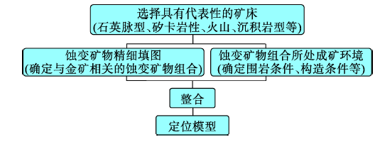
Fig. 1 Flow chart of building airborne hyperspectral remote sensing ore prospecting model图1 航空高光谱遥感矿床定位模型构建的思路图 |
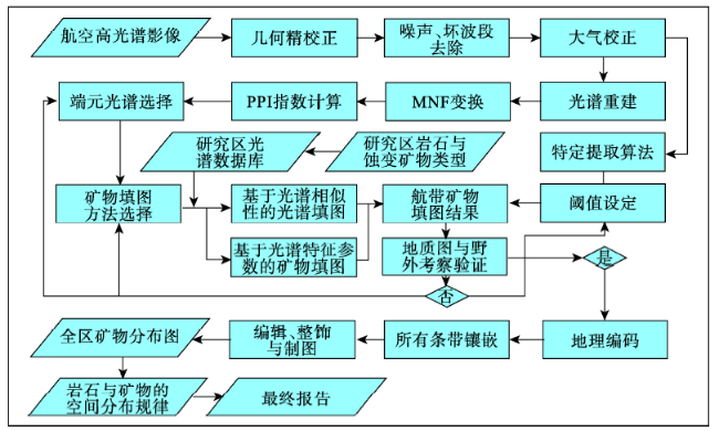
Fig. 2 Flow chart of alteration mineral mapping图2 矿床尺度精细矿物填图工作流程图 |
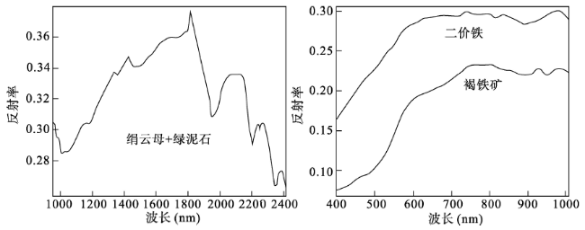
Fig. 3 Spectra patterns for the alteration minerals from the Nanjintan gold deposit图3 南金滩金矿典型蚀变矿物光谱特征图 |
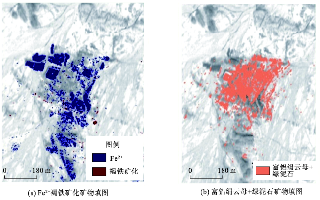
Fig. 4 Alteration mapping results for the Nanjintan gold deposit图4 南金滩金矿区矿物填图结果 |
Tab. 1 Gold abundance of rocks from the Nanjintan deposit表1 南金滩金矿床矿区岩石金元素含量表 |
| 南金滩金矿区岩性 | Au平均含量(×10–9) |
|---|---|
| 似斑状二长花岗岩 | 2.64 |
| 似斑状二长花岗岩(区域含Au较高) | 38.36 |
| 黑云母二长花岗岩 | 2.40 |
| 似斑状花岗岩中能反映原始金丰度的副矿物磁铁矿 | 115 |
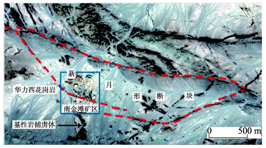
Fig. 5 Strucutral map for the Nanjintan gold deposit图5 南金滩金矿床高光谱遥感构造解译图 |
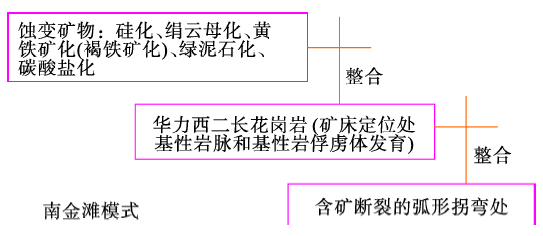
Fig. 6 Hyperspectral remote sensing gold prospecting model for the Nanjintan gold deposit图6 南金滩金矿床的高光谱遥感定位模型 |
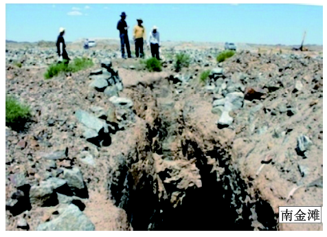
Fig. 7 Mineral deposit is controlled by silicon bearing fault图7 矿床受硅化断裂带控制野外照片 |
Tab. 2 Five typical hyperspectral remote sensing gold prospecting models for the Liuyuan area表2 柳园-方山口地区5个典型金矿床航空高光谱遥感定位模式 |
| 模式 结构 | 模式类型 | ||||
|---|---|---|---|---|---|
| 南金滩模式 | 花西山模式 | 花牛山模式 | 金沟子模式 | 老金厂模式 | |
| 蚀变 组合 | 硅化、绢云母化、褐铁矿(黄铁矿)化、绿泥石化、碳酸盐化等 | 硅化、绢云母化、褐铁矿(黄铁矿)化、蛇纹石化等 | 硅化、绢云母化、褐铁矿(黄铁矿)化、绿泥石化、碳酸盐化等 | 硅化、绢云母化、褐铁矿(黄铁矿)化等 | 硅化、绢云母化、黄铁矿化(褐铁矿化)、绿泥石化、碳酸盐化等 |
| 矿床产 出围岩 | 华力西期二长花岗岩(矿床定位处发育基性岩脉和火山岩残留体) | 印支期长条状花岗岩体(矿床定位处发育超基性岩) | 震旦系大理岩、片岩、角岩 | 华力西期石英闪长岩体 | 基-酸性火山岩和碎屑岩 |
| 构造 部位 | 含矿断裂弧形拐弯处 | 区域大断裂或岩体分支复合部位 | 蚀变岩体外接触带,褶曲构造转折处 | 入字形分支断裂和与主干断裂的夹持部位 | 受三角形断块的北缘断裂控制,矿床位于三角形断块的顶角部位 |
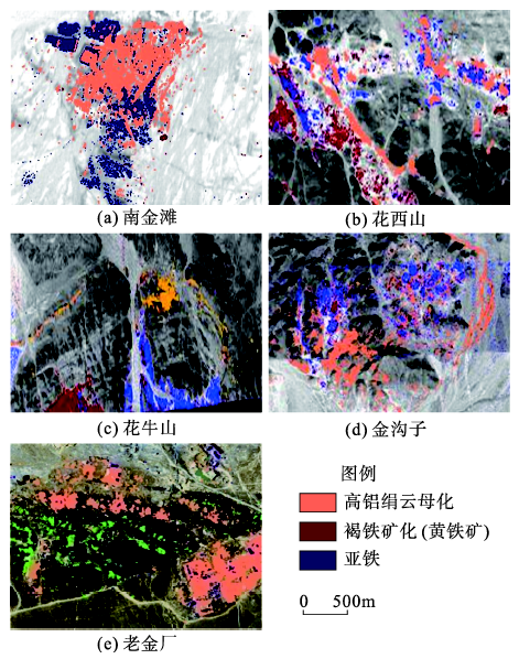
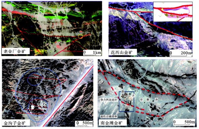
Fig. 8 Typical alteration mapping for five typical gold deposits图8 5个金矿床提取的部分蚀变矿物图 |
Fig. 9 Fault structures in typical gold deposits interpreted by hyperspectral remote sensing images图9 建模金矿床断裂构造航空高光谱遥感影像解译图 |
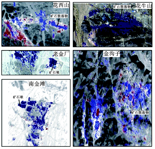
Fig. 10 Ferrous iron alteration mapping in gold deposits using airborne hyperspectral remote sensing technology图10 金矿床的矿石堆二价铁航空高光谱遥感信息提取图 |
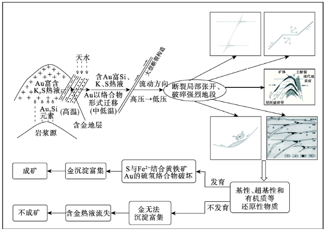
Fig. 11 Petrogenesis of gold deposits in the Liuyuan area图11 柳园地区金成矿模型图 |
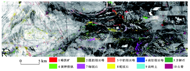
Fig. 12 Alteration distribution map for the Liuyuan area (according to SASI data)图12 柳园地区蚀变矿物区域分布图(据SASI数据) |
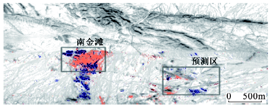
Fig. 13 Alteration distribution map for the Nanjintan deposit and the prospecting area图13 南金滩矿区和预测区蚀变矿物分布图 |
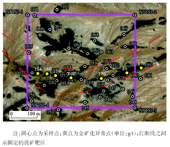
Fig. 14 Geochemistry analysis of the rock samples from the gold prospecting area图14 南金滩东找矿有利地段地表化探分析结果和圈定的找矿靶区图 |
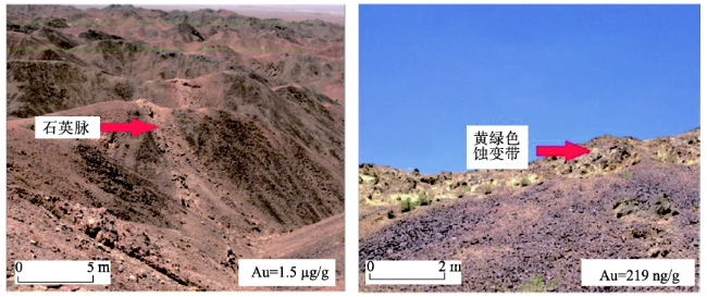
Fig. 15 Photograph of the gold anomaly with element analysis图15 新发现的另外两处找矿靶区野外照片 |
The authors have declared that no competing interests exist.
| [1] |
|
| [2] |
|
| [3] |
|
| [4] |
|
| [5] |
|
| [6] |
|
| [7] |
|
| [8] |
|
| [9] |
|
| [10] |
|
| [11] |
|
| [12] |
|
| [13] |
|
| [14] |
|
| [15] |
|
| [16] |
|
| [17] |
|
| [18] |
|
| [19] |
|
| [20] |
|
/
| 〈 |
|
〉 |