
Journal of Geo-information Science >
Extraction of Bare Soil Features from SPOT-5 Imagery Based on NDSI and NDISI
Received date: 2015-01-08
Request revised date: 2015-02-09
Online published: 2016-01-10
Copyright
The accurate mapping of bare soil land is of vital significance to soil erosion treatment. Satellite remote sensing has become a popular technology used in bare soil mapping, owing to the capability of monitoring bare soil dynamics in a cost-effective manner. Nowadays, Landsat imagery with a spatial resolution of 30 m has been widely used in previous work for bare soil extraction. Nevertheless, due to the limitation of its spatial resolution, the Landsat image can hardly meet the requirement of fine-scale bare soil mapping. Thus, a method for higher resolution bare soil mapping was proposed in this paper using SPOT-5 imagery as the main data. The Normalized Difference Soil Index (NDSI) was firstly utilized to enhance the bare soil features from the SPOT-5multispectral 10 m image. However, the enhanced soil information was mixed with the built-up land features due to the confusion between the two categories. To solve this problem, the Normalized Difference Impervious Surface Index (NDISI) was further introduced to separate the built-up features from the bare soils. Due to the lack of a thermal band in SPOT-5 imagery, which is required in computing NDISI, a near synchronous Landsat TM thermal band 6 was fine-sharpened to 10 m resolution, and afterwards, it was added to the SPOT-5 bands to calculate NDISI. Accordingly, a model was used in mapping the bare soil, based on the NDSI and NDISI. Finally, the extraction results of bare soil at 10 m resolution were obtained through the model, which achieved an overall accuracy of 95.4%. It suggests that the two-index based method can effectively eli- minate the confusion between bare soil land and built-up land, and can extract the bare soil features with a higher accuracy. In addition, the bare soil features extracted from SPOT imagery and TM imagery respectively, were further compared. It is found that a higher spatial resolution can lead to a more accurate extraction result. Therefore, the 10 m resolution SPOT-5 image is considered to be more adaptive and useful in bare soil mapping for soil erosion treatment.
Key words: bare soil; remote sensing information extraction; SPOT-5; NDSI; NDISI
LI Xia , XU Hanqiu , LI Jing , GUO Yanbin . Extraction of Bare Soil Features from SPOT-5 Imagery Based on NDSI and NDISI[J]. Journal of Geo-information Science, 2016 , 18(1) : 117 -123 . DOI: 10.3724/SP.J.1047.2016.00117
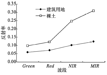
Fig. 1 Spectral signatures of bare soil and built-up land in the study area图1 实验区裸土与建筑用地的波谱曲线 |
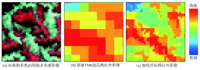
Fig. 2 Result of thermal image sharpening图2 热红外影像亚像元分解的效果 |
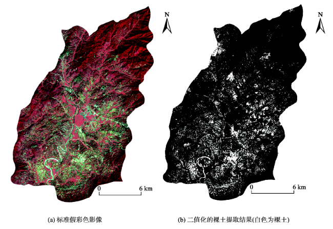
Fig. 3 Standard false color image and soil extraction result of the study area图3 研究区的裸土提取结果 |
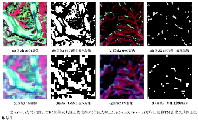
Fig. 4 Results of local bare soil extraction图4 局部的裸土提取结果 |
Tab. 1 Accuracy validation results表1 精度验证结果 |
| 参照数据 | 行总像元数 | 使用者精度(%) | 总精度(%) | Kappa系数 | |||
|---|---|---|---|---|---|---|---|
| 裸土 | 非裸土 | ||||||
| SPOT | 裸土 | 336 | 8 | 344 | 97.6 | 95.4 | 0.849 |
| 非裸土 | 15 | 141 | 156 | 90.4 | |||
| 列总像元数 | 351 | 149 | |||||
| 生产者精度(%) | 95.7 | 94.6 | |||||
| TM | 裸土 | 320 | 17 | 337 | 95.0 | 90.4 | 0.777 |
| 非裸土 | 31 | 132 | 163 | 81.0 | |||
| 列总像元数 | 351 | 149 | |||||
| 生产者精度(%) | 91.2 | 88.6 | |||||
The authors have declared that no competing interests exist.
| [1] |
[
|
| [2] |
[
|
| [3] |
[
|
| [4] |
|
| [5] |
|
| [6] |
买买提沙吾提,塔西甫拉提·特依拜,
[ Mamatsawut,
|
| [7] |
[
|
| [8] |
|
| [9] |
|
| [10] |
|
| [11] |
|
| [12] |
[
|
| [13] |
Spot Image. From Count to Irradiance[EB/OL]. , 2005.
|
| [14] |
CNES. SPOT Image Quality Performance[EB/OL]. , 2013.
|
| [15] |
[
|
| [16] |
|
| [17] |
|
| [18] |
|
| [19] |
|
| [20] |
|
| [21] |
|
| [22] |
|
| [23] |
|
| [24] |
|
/
| 〈 |
|
〉 |