
Journal of Geo-information Science >
The Discussion of Drawing Characteristics and Values of Water Conservancy Maps in Ming and Qing Dynasty
Received date: 2015-05-19
Request revised date: 2015-09-10
Online published: 2016-01-10
Copyright
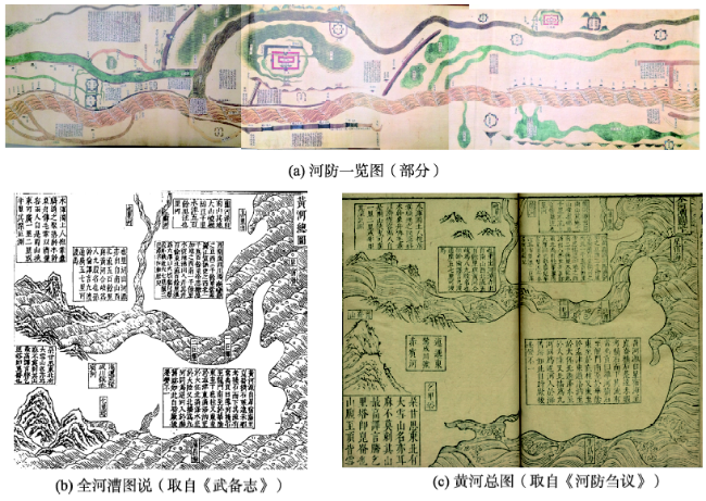
The Yellow River is called "the cradle of Chinese civilization", and the Grand Canal has taken the important responsibility of river transportation, while their importance also reveals that there were a lot of ancient maps about the Yellow River and Grand Canal. This paper mainly discusses the drawing characteristics, content summarization and value analysis of water conservancy maps in Ming and Qing Dynasty through exploring many ancient Yellow River maps and Grand Canal maps. The yellow river and canal maps in Ming and Qing Dynasty are divided into two categories based on map representations, which are the drawing (annals, illustrated) maps recorded in the water conservancy books and the illustrated maps. The illustrated map is the main type adopted in Ming and Qing dynasty which portrays the scenes of rivers and other facilities. The illustrated maps are mostly drawn in the forms of landscape painting and image rendering. Theses scroll maps aim to reproduce the historical scenes vividly. All the landscape features along the Yellow River and Grand Canal are aggregating toward the centerline of the river. This type of map can easily arouse the reader's visual resonance and build a complete picture of all features. The ancient Yellow River maps and Grand Canal maps, especially the maps produced in Ming and Qing Dynasty, based on the map drawing techniques, can be divided into three types: one is scene reproduced expand map, which is the most popular type of maps in Ming and Qing Dynasty; in addition to this type of painting maps, the painted square class maps and the latitude and longitude maps are also developed in Ming and Qing Dynasty. But these two types of ancient maps are not so popular at that time because they are not as good as the painting image maps comparing their practical and artistic aspects. No matter what types of ancient river and canal maps, they should be taken as historic legacies in mapping research, conservancy research and construction. However, in terms of their functions and values, whether the expansion scroll maps, square meter class maps, or latitude and longitude maps, are all rare historic legacies to the ancient cartography, historical geography and ancient water conservancy research, today's map research and geography research, which is worthy of in-depth study and discussion,
JIANG Lili , QI Qingwen , ZHAO Kai . The Discussion of Drawing Characteristics and Values of Water Conservancy Maps in Ming and Qing Dynasty[J]. Journal of Geo-information Science, 2016 , 18(1) : 39 -48 . DOI: 10.3724/SP.J.1047.2016.00039
Fig. 1 Ancient maps of Yellow River图1 黄河古图 |
Fig. 2 Enlarged terrestrial atlas图2 广舆图 |
Fig. 3 Ancient map of Chang Jiang图3 长江图说 |
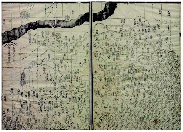
Fig. 4 Ancient map of Yellow River crossing three provinces(part)图4 御览三省黄河全图(局部) |
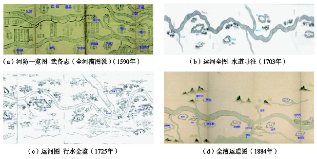
Fig. 5 Different canal maps at different times图5 不同时期同一地点运河地图 |
The authors have declared that no competing interests exist.
| [1] |
[
|
| [2] |
[
|
| [3] |
[
|
| [4] |
[
|
| [5] |
[
|
| [6] |
[
|
| [7] |
[
|
| [8] |
[
|
| [9] |
[
|
| [10] |
[
|
| [11] |
[
|
| [12] |
[
|
| [13] |
[
|
| [14] |
[
|
| [15] |
[
|
| [16] |
[
|
| [17] |
[
|
| [18] |
[
|
| [19] |
[
|
| [20] |
[
|
| [21] |
[
|
| [22] |
[
|
| [23] |
[
|
| [24] |
[
|
| [25] |
[
|
| [26] |
[
|
| [27] |
[
|
| [28] |
[
|
/
| 〈 |
|
〉 |