
Journal of Geo-information Science >
The Characteristic and Value of Provincial and Regional Maps in Near Modern China
Received date: 2015-05-11
Request revised date: 2015-07-16
Online published: 2016-01-10
Copyright
Map drawing in near modern China (Ming Dynasty, Qing Dynasty and Republic of China) is the best representation of Chinese ancient cartography. The later stage of Chinese feudal society was the transition period that ancient cartography was changing to modern cartography. It’s necessary to research the maps made in the near modern period. Provincial and regional maps of near modern China reveal more characteristics than other types of maps in that period. Through collecting the maps of near modern China, the characteristics of provincial and regional maps of near modern China were discussed from two aspects, including the arrangement systems and expression methods. The arrangement systems of provincial and regional maps in near modern China were further divided into two parts, one is the different publication formats during the same period, such as single pieces of maps from historical records and maps included in atlas and encyclopaedia, the other is the arrangement system classification and subdivision based on administrative divisions. The expression methods of provincial and regional maps in near modern China were divided into three parts, including the expression method characteristics of single provincial and regional map, provincial and regional maps in encyclopaedia, and provincial and regional atlas. It is of significant value to research the provincial and regional maps of near modern China. Through these studies and comparisons of modern atlas within various periods, we can further study the peculiarities of provincial administrative division, inner structure of provincial physical geography unit and strengthening management of province and region. This paper lays a foundation to the further study of the provincial and regional maps of near modern China, and also provided a reference for the drawing of provincial and regional maps and the compiling of atlas in modern China.
Key words: modern China; province and region; arrangement systems; mapping characteristics; atlas; value
YE Yanjun , ZHANG An , QI Qingwen . The Characteristic and Value of Provincial and Regional Maps in Near Modern China[J]. Journal of Geo-information Science, 2016 , 18(1) : 57 -67 . DOI: 10.3724/SP.J.1047.2016.00057
Tab. 1 Provincial and regional maps in modern China (section)表1 中国近代省区地图资料(部分) |
| 朝代 | 种类 | 图名/书名 | 成图时间(年) | 作者/出版机构 |
|---|---|---|---|---|
| 明代 | 单幅地图 | 陕西舆图 | 1644-1661 | - |
| 百科全书 | 皇舆考 | 1557 | 张天复 | |
| 三才图会 | 1607 | 王圻、王思义 | ||
| 方舆胜略十八卷 | - | - | ||
| 武备志 | 1594-1644 | 茅元仪 | ||
| 图书编 | 1613 | 章潢 | ||
| 综合性地图集 | 广舆图 | 1541 | 罗洪先 | |
| 皇明职方地图 | 1636 | 陈组绶 | ||
| 地图综要 | - | 吴学俨、朱绍本 | ||
| 省和区域地图集 | 江西全省图说 | 1612-1617 | - | |
| 清代 | 单幅地图 | 晋省舆地全图 | 1794 | 李宝甫 |
| 内外蒙古图 | 1864 | 湖北官书局 | ||
| 全国地图集 | 大清帝国全图 | 1908 | 上海商务印书馆 | |
| 大清分省分藩精图 | 1908 | 国文堂书局 | ||
| 乾隆府厅州县图志 | 1788-1803 | 洪亮吉 | ||
| 皇朝直省地舆全图 | 1880 | 上海点石斋石印 | ||
| 省和区域地图集 | 贵州全省舆图说 | 1732-1770 | - | |
| 安徽省舆图 | 1754-1777 | - | ||
| 直隶通省舆图 | 1862 | 徐志导 | ||
| 四川全图 | 1864 | 湖北官书局 | ||
| 山东全图 | 1875-1890 | 叶奎绶 | ||
| 东三省舆地图说 | 1887 | 曹廷杰 | ||
| 广西舆地全图 | 1895 | - | ||
| 湖南全省舆地图表 | 1896 | 陈宝箴 | ||
| 江西全省舆图 | 1896 | 朱兆麟 | ||
| 湖南舆图 | 1897 | 左学吕 | ||
| 黑龙江舆地图 | 1899 | - | ||
| 福建全省舆地图 | 1905 | - | ||
| 广东舆地全图 | 1909 | 广东参处测绘科 | ||
| 湖北全省分图 | 1909 | 舆地学会 | ||
| 民国 | 单幅地图 | 陕甘青海套西图 | 1925 | 苏甲荣 |
| 贵州分县新图 | 1932 | 亚新地图学社 | ||
| 西南各省详图 | 1940 | 王守成 | ||
| 全国地图集 | 中华民国分省形势全图 | 1917 | 同伦学社 | |
| 中华民国省区全图 | 1926 | 北京中央地学社 | ||
| 大中华民国分省图 | 1929 | 武昌亚新地学社 | ||
| 中华析类分省图 | 1929 | 亚新地学社 | ||
| 中华民国分省新图 | 1934 | 上海申报馆 | ||
| 中国分省地图 | 1945 | 中国制图社 | ||
| 新中国分省图 | 1946 | 新中国出版社 | ||
| 中华民国最新分省地图 | 1946 | 寰澄出版社 | ||
| 新中华分省精图 | 1948 | 武昌亚新地学社 | ||
| 最新中国分省地图 | 1948 | 中华书局 | ||
| 省和区域地图集 | 江苏全省分图 | 1912 | 武昌亚新地学社 | |
| 河南分县详图 | 1914 | 武昌亚新地学社 | ||
| 湖南分县详图 | 1928 | 武昌亚新地学社 | ||
| 湖北分县详图 | 1930 | 亚新地学社 | ||
| 江西分县详图 | 1931 | 武昌亚新地学社 | ||
| 浙江分县地图 | 1934 | 亚新地学社 | ||
| 河北分县详图 | 1933 | 武昌亚新地学社 | ||
| 绥远分县图 | 1933 | 绥远华北印刷局 | ||
| 甘肃省县总分图 | 1934 | 甘肃通志馆 |
Fig. 1 Terrestrial atlas of Guangdong (1887 in Qing Dynasty)图1 广东舆地全图(清光绪二十三年1887年) |
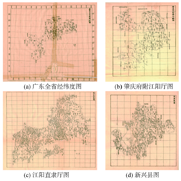
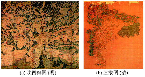
Fig. 2 Comparison of the drawing characteristics of single pieces of provincial and regional maps at different times图2 不同时期单幅省区地图绘制特色对比 |
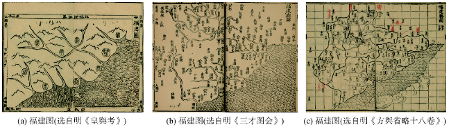
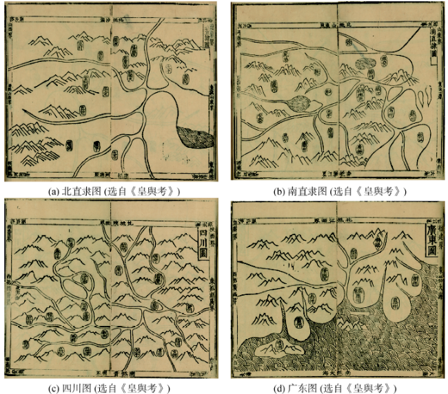
Fig. 3 Map drawing characteristics of provincial and regional maps in encyclopaedia图3 百科全书中省区地图的绘制特色 |
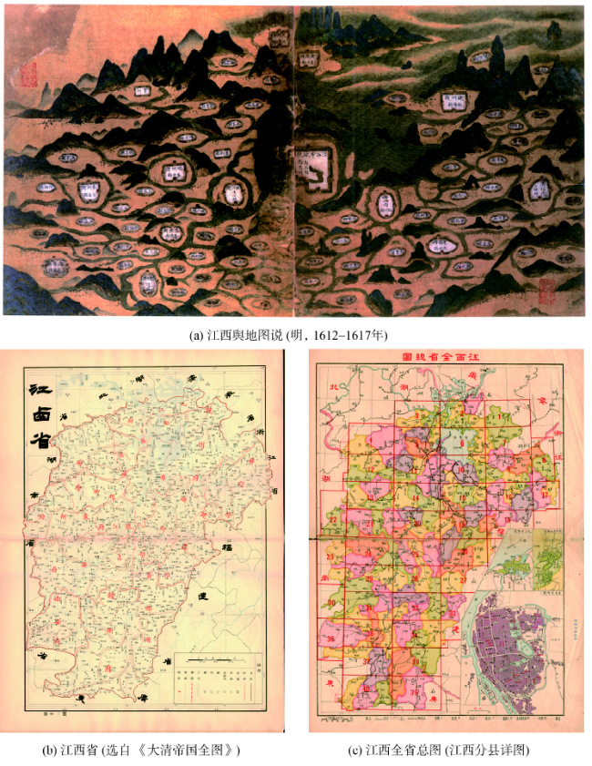
Fig. 4 Comparisons of map drawingc characteristics of provincial and regional atlas at different times图4 不同时期省区地图集绘制特色对比 |
Fig. 5 Comparison of the inner structure between Beijing City, Nanjing City, Sichuan Province and Guangdong Province图5 北京市、南京市、四川省和广东省内部格局对比 |
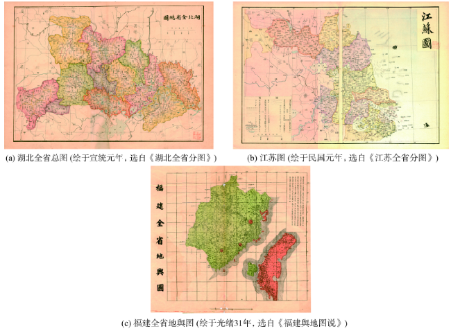
Fig. 6 Comparison of geographical uniqueness between Hubei Province, Jiangsu Province and Fujian Province图6 湖北省、江苏省和福建省地理独特性对比 |
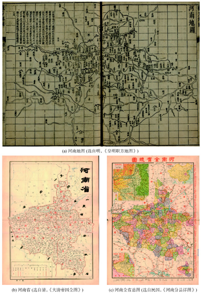
Fig. 7 Historical evolution of administrativedivisions of Henan Province图7 河南省行政单元划分的历史演变 |
The authors have declared that no competing interests exist.
| [1] |
[
|
| [2] |
[
|
| [3] |
[
|
| [4] |
[
|
| [5] |
[
|
| [6] |
[
|
| [7] |
|
| [8] |
[
|
| [9] |
[
|
| [10] |
[
|
| [11] |
[
|
| [12] |
[
|
| [13] |
[
|
| [14] |
|
| [15] |
[
|
| [16] |
[
|
| [17] |
[
|
| [18] |
[
|
| [19] |
[
|
| [20] |
[
|
| [21] |
[
|
| [22] |
[
|
| [23] |
“中华舆图志编制及数字展示”项目组.中华舆图志[M].北京:中国地图出版社,2011.
[
|
| [24] |
[
|
/
| 〈 |
|
〉 |