
Journal of Geo-information Science >
Shoulder Line Extraction in the Loess Plateau Based on Region Growing Algorithm
Received date: 2013-11-15
Request revised date: 2014-03-26
Online published: 2016-02-04
Copyright
Shoulder line is one of the most effective terrain structure line used to describe the loess landform. It plays an important role in the study of the spatial distribution and landform evolution of the loess landform. Shoulder line lies on the boundary of the positive and negative terrain, where the elevation and slope of the loess surface reveal obvious changes. Many efforts have been done for the extraction of shoulder line, but these methods have disadvantages, of which the experimental process requires human intervention or the shoulder line is discontinuous. P-N terrain method can effectively extract the shoulder line, but while using this method to segment the positive and negative terrains, it tends to produce large amounts of broken polygons and classification errors, which affect the accuracy of shoulder line. This paper investigates a region growing algorithm to improve the P-N terrain method. Using the highest elevation of the local area as a growing point for positive terrain and the outlet as a growing point for negative terrain, four-neighborhood growth were carried out until they reached the boundary of the positive and negative terrains or a slope threshold. Then the edge detection method was used to extract the critical boundary. Finally, the morphological image processing method was used to eliminate burrs to get the final shoulder line. In order to verify the result, this paper used the 0.6 m resolution remote sensing image to get the relatively accurate shoulder line by visual interpretation. And then different results were compared using overlay analysis. It is revealed that the shoulder line extracted using the improved method is closer to the visual interpretation results. This method is an automatic way to extract shoulder line, which solves the inaccurate location problem of P-N terrain method. Meanwhile, this method keeps the integrity and continuity of shoulder line and avoids the emergence of broken shoulder line and closure shoulder line. The use of morphological image processing method in burrs removal also ensures the accuracy.
LIU Wei , LI Fayuan , XIONG Liyang , LIU Shuanglin , WANG Ke . Shoulder Line Extraction in the Loess Plateau Based on Region Growing Algorithm[J]. Journal of Geo-information Science, 2016 , 18(2) : 220 -226 . DOI: 10.3724/SP.J.1047.2016. 00220
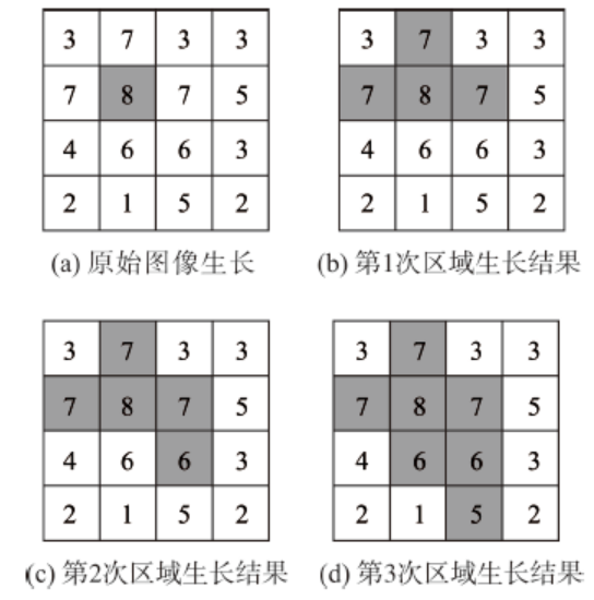
Fig. 1 Illusions of region growing图1 区域生长示意图 |
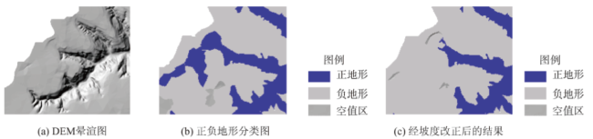
Fig. 2 Influence of slope to the positive and negative terrain classification result图2 坡度对正负地形分类结果的影响 |
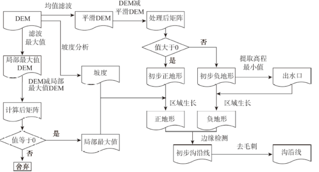
Fig. 3 Flow chart of the study图3 流程图 |
Fig. 4 The contrast between shoulder line and other features图4 沟沿线和非沟沿线边界对比图 |
Fig. 5 Edge detection operators图5 边缘检测算子 |
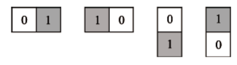
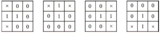
Fig. 6 Structure element图6 结构元 |
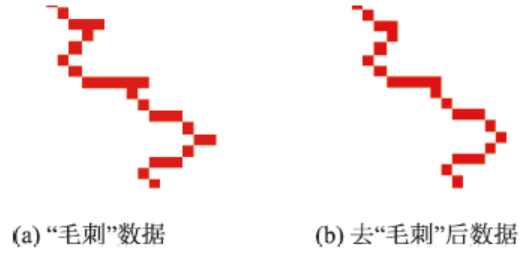
Fig. 7 The contrast of data before and after burr removal图7 去“毛刺”前后对比图 |
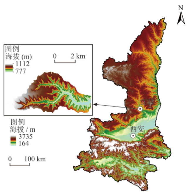
Fig. 8 Test area and data图8 实验样区及数据 |
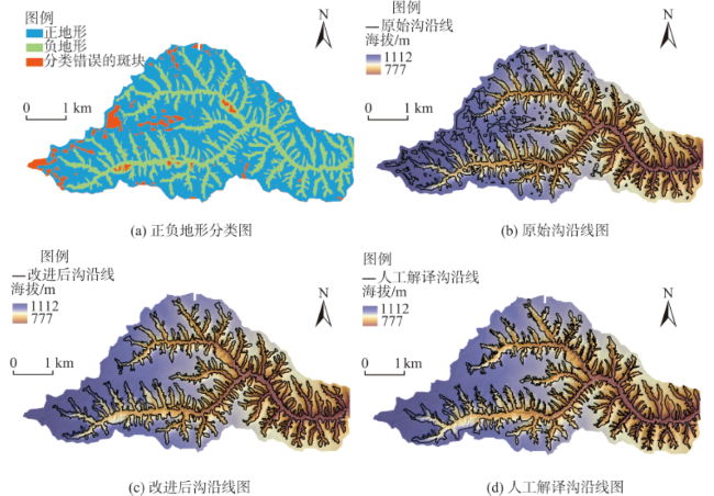
Fig. 9 Positive and negative terrains and shoulder line图9 正负地形及沟沿线 |
Tab. 1 The percentage of grid numbers of shoulder line to the total grid numbers within a certain displacement表1 位移栅格内沟沿线栅格数目占总栅格数目的百分比 |
| 人工解译沟沿线的位移栅格数目/个 | 位移栅格内,坡面畸变法提取沟沿线栅格数目/个 | 占坡面畸变法提取沟沿线总栅格数的百分比/(%) | 位移栅格内,区域生长法提取沟沿线栅格数目/个 | 占区域生长法提取沟沿线总栅格数的百分比/(%) |
|---|---|---|---|---|
| 3 | 33 072 | 64.02 | 23 494 | 78.07 |
| 5 | 38 539 | 74.61 | 27 231 | 90.49 |
| 7 | 40 381 | 78.17 | 28 469 | 94.60 |
The authors have declared that no competing interests exist.
| [1] |
[
|
| [2] |
[
|
| [3] |
[
|
| [4] |
[
|
| [5] |
[
|
| [6] |
[
|
| [7] |
|
| [8] |
|
| [9] |
[
|
| [10] |
[
|
| [11] |
[
|
| [12] |
[
|
| [13] |
|
| [14] |
[
|
| [15] |
|
| [16] |
[
|
| [17] |
[
|
| [18] |
|
| [19] |
[
|
| [20] |
[
|
| [21] |
[
|
| [22] |
[
|
| [23] |
[
|
| [24] |
[
|
| [25] |
|
| [26] |
|
| [27] |
[
|
| [28] |
[
|
| [29] |
|
/
| 〈 |
|
〉 |
