
Journal of Geo-information Science >
Analyses of Poverty Risk Induced by Mountain Disasters: A Case Study in Enshi, China
Received date: 2015-07-15
Request revised date: 2015-12-31
Online published: 2016-03-10
Copyright
Most of the poverty areas in China are mainly distributed in the mountainous areas, which are also prone to several mountain disasters. These disasters may lead or enhance the poverty to some extent. Current research on mountain disaster mainly focuses on the kinetics whereas pays less attention on the risks, especially on the risk of poverty. The authors distinguished the specific mountain disasters from the common disasters, and summarized the characteristics of mountain disasters, then give out the explanation of poverty vulnerability and poverty risk induced by mountain disasters. The poverty risk model is set up from the perspectives of two aspects, the hazard and the vulnerability, where the hazard is a function of susceptibility, and the vulnerability is consisted of the copping ability and exposure. With this concept, a demonstrative research is carried out for Enshi in Hubei province, which is located in the central China and is a minority mountainous area in severe poverty condition. In this demonstration, the hazard susceptibility is obtained from the landslide historical records and geological environments background analysis. As the vulnerability, the building structure intensity and completeness of infrastructure, and the net income of the farmers were factors of the copping ability, while the density of cultivated land ratio, the poverty population rate and the GDP were factors of the exposure. The final poverty risk map was produced with the upper dual-factor model and was divided into 5 levels for usability. In the end, some suggestions about poverty-reduction and disaster mitigation were introduced by the authors from the perspective of poverty risk, such as the integrate disaster and poverty reduction, and some other management policies were also recommended.
Key words: poverty; mountain disasters; risk; vulnerability
TIAN Hongling , ZHANG Jianqiang . Analyses of Poverty Risk Induced by Mountain Disasters: A Case Study in Enshi, China[J]. Journal of Geo-information Science, 2016 , 18(3) : 307 -314 . DOI: 10.3724/SP.J.1047.2016.00307
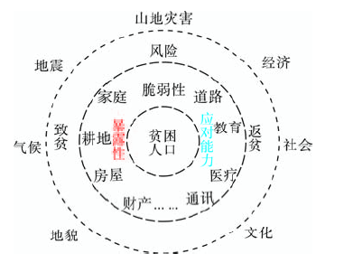
Fig. 1 Mountain disasters, vulnerability and risk of poverty图1 山地灾害,贫困脆弱性与贫困风险 |
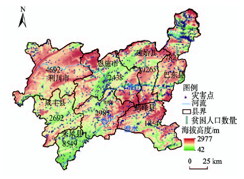
Fig. 2 Distributions of mountain disasters and the poverty population in Enshi, China图2 研究区山地灾害与贫困人口分布示意图 |
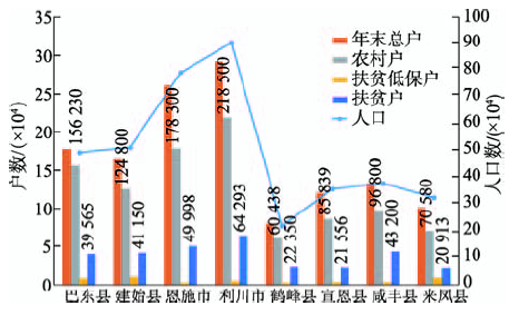
Fig. 3 Statistics of the poverty population in Enshi, China (2013)图3 恩施州贫困人口统计图(据民政部2013年统计数据) |
Tab. 1 Landsides susceptibility factor weights and data sources of Enshi, China表1 恩施州山地质灾害危险性评价指标及数据来源 |
| 指标名称及权重 | 数据来源 | 数据描述 | |||
|---|---|---|---|---|---|
| 一级指标 | 权重 | 二级指标 | 权重 | ||
| 地形地貌 | 0.6571 | 高程 | 0.0312 | ASTER GDEM | 分辨率为30 m×30 m |
| 坡度 | 0.4301 | ASTER GDEM | 由GDEM导出 | ||
| 坡型 | 0.1302 | ASTER GDEM | 由GDEM导出 | ||
| 沟谷密度 | 0.0657 | ASTER GDEM | 由GDEM导出 | ||
| 地质 | 0.2746 | 地层岩性 | 0.0687 | 1:50万地质图 | 岩性类型 |
| 断裂带距离 | 0.2060 | 1:50万地质图 | 由地质图断层导出 | ||
| 人类活动 | 0.0683 | 道路距离 | 0.0171 | 1:10万基础地理图 | 由道路图层计算 |
| 土地利用 | 0.0512 | Landsat TM | 遥感影像提取 | ||
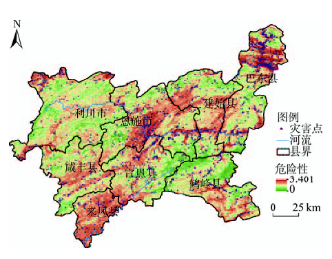
Fig. 4 Hazard map of mountain disasters in Enshi, Hubei图4 恩施州山地灾害危险性分布示意图 |
Tab. 2 Factors of poverty vulnerability in Enshi, China表2 恩施州贫困脆弱性指标 |
| 指标级别 | 数据处理说明 | ||
|---|---|---|---|
| 一级指标 | 二级指标 | 三级指标 | |
| 暴露性 | 生态环境 | 耕地密度 | |
| 脆弱人员 | 贫困人口比率 | 贫困户/农村户 | |
| 经济能力 | 社会经济能力 | GDP | |
| 应对能力 | 社会应灾能力 | 基础设施完备性 | 道路,医院,通讯等加权 |
| 家庭应灾能力 | 房屋强度 | 修建年度和结构形式 | |
| 应灾资金 | 应灾资金 | 农民纯收入 | |
Tab. 3 Vulnerability data of Enshi, China表3 恩施州贫困脆弱性数据表 |
| 地区 | 耕地密度 | 贫困人口比 | GDP | 基础设施 | 房屋强度 | 农民纯收入 | 脆弱性 |
|---|---|---|---|---|---|---|---|
| 巴东县 | 0.284471 | 0.2532 | 0.4793 | 0.6845 | 0.453659 | 0.7698 | 0.11 |
| 建始县 | 0.284767 | 0.3297 | 0.1590 | 0.7045 | 0.466610 | 0.0000 | 0.14 |
| 恩施市 | 0.289606 | 0.2804 | 1.0000 | 0.6712 | 0.414210 | 0.0080 | 0.30 |
| 利川市 | 0.271713 | 0.2942 | 0.6076 | 0.8275 | 0.434373 | 0.7869 | 0.12 |
| 鹤峰县 | 0.187099 | 0.3698 | 0.0000 | 0.1858 | 0.673524 | 1.0000 | 0.06 |
| 宣恩县 | 0.323984 | 0.2511 | 0.0745 | 0.6164 | 0.771706 | 0.7446 | 0.06 |
| 咸丰县 | 0.326294 | 0.4463 | 0.2044 | 0.0561 | 0.713088 | 0.7766 | 0.13 |
| 来凤县 | 0.378903 | 0.2963 | 0.0850 | 0.5427 | 0.623655 | 0.7468 | 0.08 |
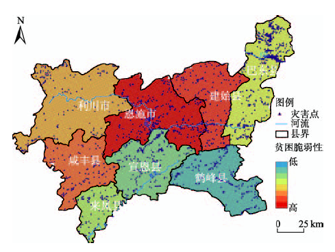
Fig. 5 Poverty vulnerability networks of Enshi, Hubei图5 恩施州贫困脆弱性评价网格图 |
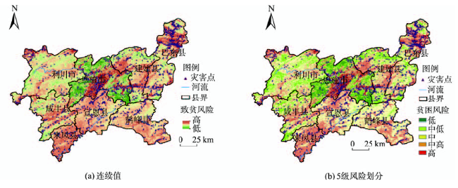
Tab. 4 Percentage of different risk levels表4 山地灾害致贫风险分级比例统计表 |
| 级别 | 格网数目 | 比例/(%) |
|---|---|---|
| 低 | 10 415 | 3.6 |
| 中低 | 52 157 | 18.2 |
| 中 | 122 501 | 42.7 |
| 中高 | 87 094 | 30.3 |
| 高 | 15 005 | 5.2 |
Fig. 6 Risk of poverty induced by mountain disasters in Enshi, Hubei图6 恩施州山地灾害致贫风险评价 |
The authors have declared that no competing interests exist.
| [1] |
[
|
| [2] |
[
|
| [3] |
中共中央,国务院,中国农村扶贫开发纲要(2011-2020年)[Z]. 2011-12-01.
[ The Central Committee of the Communist Party of China, the Sate Council. Outline of poverty alleviation and development in rural areas of China (2011-2020)[z].2011-12-01. ]
|
| [4] |
[
|
| [5] |
[
|
| [6] |
[
|
| [7] |
[
|
| [8] |
[
|
| [9] |
[
|
| [10] |
|
| [11] |
[
|
| [12] |
[
|
| [13] |
[
|
| [14] |
|
| [15] |
[
|
| [16] |
The World Bank. World development report: development and the environment[R]. Oxford University Press, 1992.
|
| [17] |
United Nations Development Programme. Millennium development goals: a compact among nations to end human poverty[R]. New York: Oxford University Press, 2003.
|
| [18] |
|
| [19] |
|
| [20] |
[
|
| [21] |
[
|
| [22] |
[
|
| [23] |
[
|
| [24] |
Africa Region Human Development Department of the World Bank. Dynamic risk management and the poor, developing a social protection strategy for Africa[M]. The World Bank, 2000.
|
| [25] |
|
| [26] |
[
|
| [27] |
|
| [28] |
[
|
| [29] |
[
|
| [30] |
恩施自治州建州三十周年的回顾与展望[EB/OL]..
[ Review and prospect of Enshi Autonomous since setting up[EB/OL]. . ]
|
| [31] |
[
|
| [32] |
[
|
| [33] |
[
|
| [34] |
[
|
/
| 〈 |
|
〉 |