
Journal of Geo-information Science >
A Fragile Watermarking Algorithm for Integrity Authentication of DEM Based on the Terrain Feature
Received date: 2015-05-13
Request revised date: 2015-06-05
Online published: 2016-03-10
Copyright
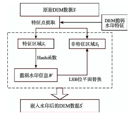
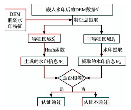
Considering the necessity of integrity certification and the lack of certification methods for DEM, an integrity certification algorithm based on fragile watermarking for DEM was proposed, which had fully taken the terrain features into account. The characteristic of DEM data is analyzed in order to propose the special requirements of the fragile watermarking technology. To reduce the impact of watermarked data, in the process of fragile watermark embedding, based on the feature lines extracted from the original DEM data, the data was firstly divided into two different parts: the feature region and non-feature region. Secondly, the fragile watermarking information was generated according to the number of raster in feature region and watermarking sequence segments, and then it was embedded into the non-feature region by LSB-based method. In the integrity certification process, the same feature region was extracted from DEM data, and the regenerated watermark information was compared with the extracted one in order to determine the integrity of the data. Finally, experiments using the proposed algorithms were presented. Experimental results show that the presented algorithm not only is able to effectively certificate the integrity of DEM data, but also has little influence on the data accuracy. In addition, the algorithm has high security and suitability.
ZHU Changqing , XU Hui , REN Na . A Fragile Watermarking Algorithm for Integrity Authentication of DEM Based on the Terrain Feature[J]. Journal of Geo-information Science, 2016 , 18(3) : 369 -375 . DOI: 10.3724/SP.J.1047.2016.00369
Fig. 1 Flow chart of watermark generation and embedding图1 水印生成与嵌入流程图 |
Fig. 2 Flow chart of watermark detection图2 水印检测流程图 |
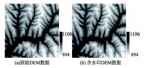
Fig. 3 The original and watermarked DEM data图3 嵌入水印前与嵌入水印后的DEM数据 |
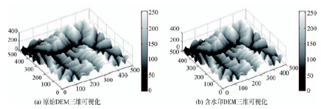
Fig. 4 The 3-D visualization renderings of the original and watermarked DEM图4 原始DEM与含水印DEM的三维可视化效果图 |
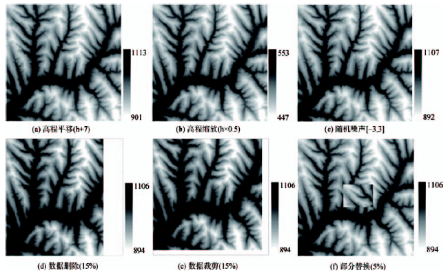
Fig. 5 The watermarked DEM data under different modifing method图5 不同修改方式下的含水印DEM数据晕渲效果图 |
Tab. 1 The experimental results of certification accuracy analysis表1 认证准确性分析实验结果 |
| DEM数据编号 | 修改方式 | 认证结果 | 认证准确性 |
|---|---|---|---|
| 图3(b) | 不作修改 | 通过 | 正确 |
| 图5(a) | 高程平移(h+7) | 不通过 | 正确 |
| 图5(b) | 高程缩放(h*0.5) | 不通过 | 正确 |
| 图5(c) | 随机噪声[-3,3] | 不通过 | 正确 |
| 图5(d) | 数据删除(15%) | 不通过 | 正确 |
| 图5(e) | 数据裁剪(15%) | 不通过 | 正确 |
| 图5(f) | 部分替换(5%) | 不通过 | 正确 |
Tab. 2 The basic statistical information of the original and watermarked DEM表2 水印嵌入前后DEM数据基本统计信息(m) |
| 高程最小值 | 高程最大值 | 平均高程值 | 标准差 | |
|---|---|---|---|---|
| 原始DEM | 894.56 | 1106.71 | 993.81 | 40.74 |
| 含水印DEM | 894.57 | 1106.71 | 993.79 | 40.75 |
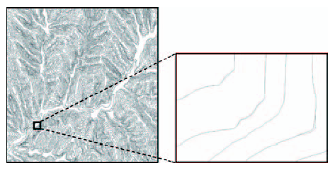
Fig. 6 The comparison result of contours extracted from the original and watermarked DEM图6 原始DEM与含水印DEM提取等高线结果对比图 |
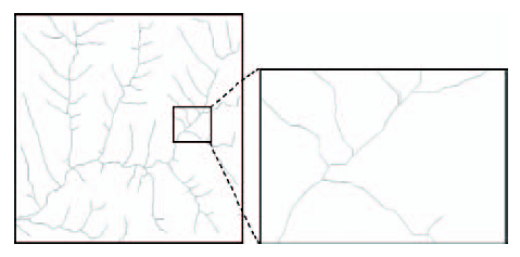
Fig. 7 The comparison result of stream networks extracted from the original and watermarked DEM图7 原始DEM与含水印DEM提取汇水线结果对比图 |
The authors have declared that no competing interests exist.
| [1] |
[
|
| [2] |
[
|
| [3] |
[
|
| [4] |
|
| [5] |
[
|
| [6] |
[
|
| [7] |
|
| [8] |
[
|
| [9] |
|
| [10] |
|
| [11] |
|
| [12] |
[
|
| [13] |
CH/T 9009. 2-2010,基础地理信息数字成果1:5000,1:10000,1:25000,1:50000,1:100000数字高程模型[S].2010.
[ CH/T 9009. 2-2010, Digital products of fundamental geographic information.1:5000 1:10000 1:25000 1:50000 1:100000 digital elevation models[S].2010. ]
|
/
| 〈 |
|
〉 |