
Journal of Geo-information Science >
3D Building Model Hierarchical Generalization Based on Building Contour and Texture
Received date: 2015-05-08
Request revised date: 2015-06-24
Online published: 2016-03-10
Copyright
As a major factor of smart city, 3D building model has been widely applied in many fields such as city planning, navigation and virtual geographic environments. Level of detail (LOD) technology is often used to visualize these models in complex urban environment. In order to reduce the high production cost, 3D building model generalization is gradually attracting attention. 3D building model generalization includes single model simplification, which has been studied widely and deeply, and multiple models synthesis, which is still at its early stages. In this paper, a self-organizing map (SOM) based classification algorithm is used to analyze the texture, and then the texture is combined with geometry feature to generalize 3D building models. In addition, a cognition-based hierarchical clustering algorithm is proposed. Firstly, a constrained Delaunay triangulation (CDT) is constructed from the 2D footprints of building models, and a connected network is established by visibility analysis based on the CDT, which is divided based on the road network to make it conform to the urban morphology theory. An initial proximity graph is constructed from the CDT. Secondly, the proximity graph is segmented according to the texture feature. Finally, a minimum spanning tree (MST) is created from the proximity graphic based on the minimum distance, and after linear detection and discrete model conflation, the model groups are conflated and visualized. The texture feature is used to synthesize 3D model that is adaptive to people's cognitive habits. The experimental results confirm the effectiveness of this method.
Key words: 3D building models; generalization; building contour; texture; SOM
PAN Wenbin , LIU Po , ZHOU Jieping , GONG Jianhua . 3D Building Model Hierarchical Generalization Based on Building Contour and Texture[J]. Journal of Geo-information Science, 2016 , 18(3) : 406 -415 . DOI: 10.3724/SP.J.1047.2016.00406
Fig. 1 The framework of the algorithm图1 算法的主要框架 |
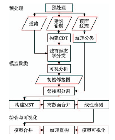
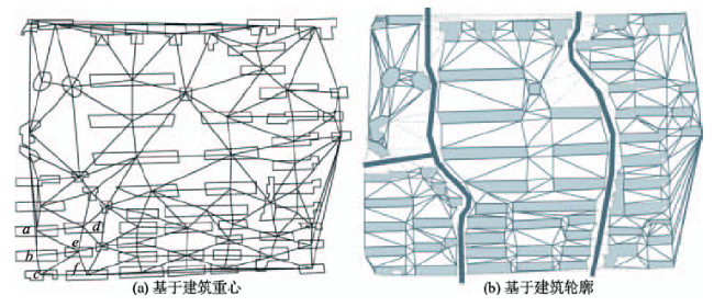
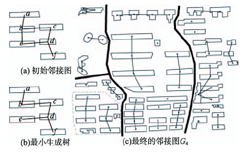
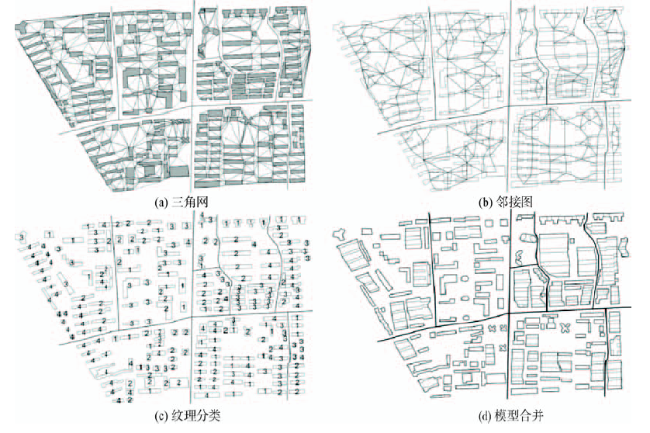
Fig. 2 Delaunay triangulation图2 Delaunay三角网 |
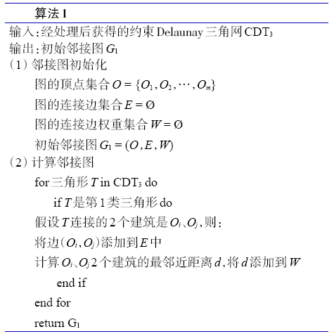
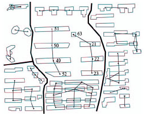
Fig. 3 Proximity graph图3 邻接图 |
Fig. 4 Texture analysis图4 纹理分析 |
Fig. 5 Texture classification图5 纹理分类 |
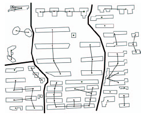
Fig. 6 The proximity graph G2 after texture classification图6 纹理分类之后的邻接图G2 |
Fig. 7 MST (Minimum Spanning Tree)图7 最小生成树 |
Fig. 8 Linear detection图8 线性检测 |
Fig. 9 Discrete model group图9 离散模型聚类 |
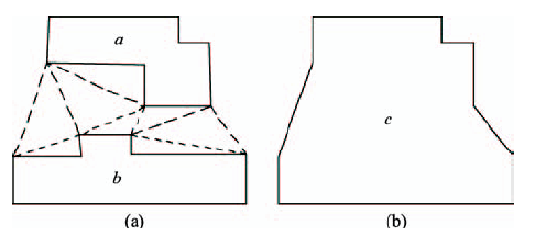
Fig. 10 Polygon conflation图10 底面合并 |
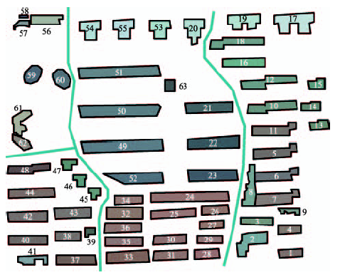
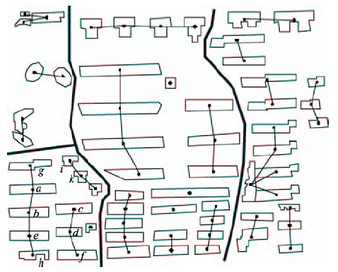
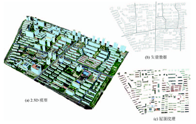
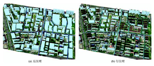
Fig. 11 Experimental data图11 研究区数据 |
Fig. 12 Experimental result图12 实验结果 |
Fig. 13 Model conflation图13 模型合并 |
The authors have declared that no competing interests exist.
| [1] |
[
|
| [2] |
|
| [3] |
|
| [4] |
|
| [5] |
|
| [6] |
|
| [7] |
|
| [8] |
|
| [9] |
|
| [10] |
|
| [11] |
|
| [12] |
|
| [13] |
|
| [14] |
|
| [15] |
|
| [16] |
|
| [17] |
|
| [18] |
|
| [19] |
|
| [20] |
[
|
| [21] |
|
| [22] |
|
| [23] |
|
/
| 〈 |
|
〉 |
