
Journal of Geo-information Science >
Principle and Methods on Layout Based Web Map Publishing Mode with Integrated Map Data and High Fidelity
Received date: 2015-11-03
Request revised date: 2016-03-02
Online published: 2016-04-19
Copyright
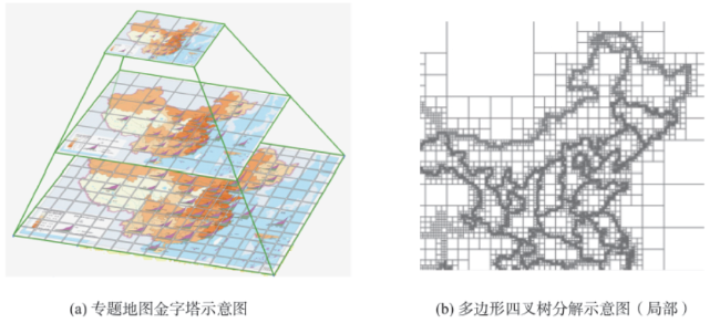
Based on the analysis of the status quo on web map publishing, particularly the status quo on thematic map publishing, a new concept of layout based web map was proposed. The layout based web map changes the GIS system tendency and static images map tendency of thematic map publishing. It provides the high fidelity map quality, meanwhile realizes the simultaneous publishing of thematic data and thematic map. This paper introduces the design and implementation techniques of the publish system on layout based web map. These techniques decompose the thematic map image and the polygon data into a quad-tree mode. On one hand, it divides the thematic map image into a map tile pyramid with given regular grid size. On the other hand, the thematic data features (mostly are the polygon features) are decomposed into grid dataset with variable resolution. It records every grid attribute based on a unique identification and stores the complex thematic data with information of its region, time, index and value as a data element, which increase the efficiency in thematic data query. In addition, this paper introduces two application scenarios. The first one is a topographic map document published in the EPS format. The second one is a layout based web map publishing system for the “Atlas on Population and Environment, People′s Republic of China”. A comparison of the merits and demerits was made among five web map publishing modes, including WebGIS, static images, PDF/GeoPDF map, SVG map and layout based web map. The layout based web map approach with high fidelity and interactive maps is considered to be promising for the digital thematic map publishing in the web mapping field.
LI Heyuan , LI Hongsheng , HAN Jiafu , LUO Bin . Principle and Methods on Layout Based Web Map Publishing Mode with Integrated Map Data and High Fidelity[J]. Journal of Geo-information Science, 2016 , 18(4) : 469 -476 . DOI: 10.3724/SP.J.1047.2016.00469
Fig. 1 Illustration of the thematic map tile pyramid and the polygon quadtree decomposition图1 专题地图瓦片金字塔和多边形四叉树分解示意图 |
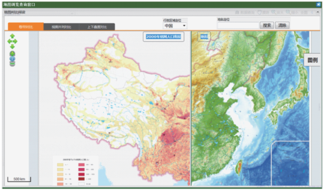
Fig. 2 Contrast map reading in the layout based web map图2 版式网络地图对比阅读 |
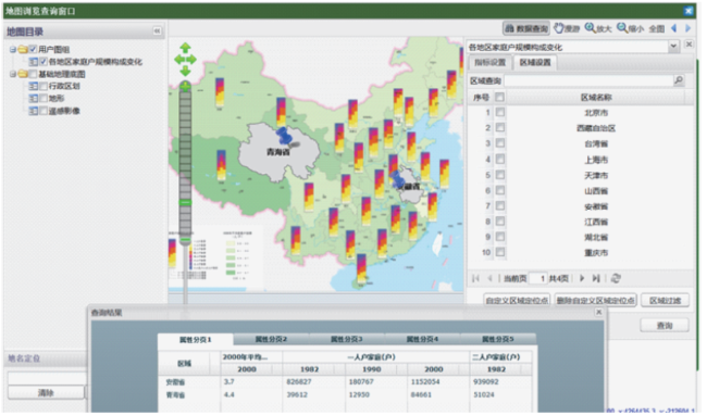
Fig. 3 Interactive data query in the layout based web map图3 版式网络地图数据交互式查询 |
Tab. 1 Comparison of web map′s publishing modes表1 网络地图发布模式对比 |
| 模式 | 交互性 | 比例尺 | 阅读友好性 | 分析 | 认知工效 |
|---|---|---|---|---|---|
| WebGIS模式 | 高(界面和内容交互) | 支持缩放 | 低(常出现注记或符号压盖现象) | 高(支持空间分析能力,支持程度根据系统功能确定) | 中(高灵活性与特定知识表达的权衡) |
| 静态地图图片模式 | 低 | 比例尺固定 | 低(显示效果取决于分辨率) | 低(不支持) | 低(易读性差) |
| PDF/GeoPDF地图发布模式 | 中(基于插件实现) | 支持缩放 | 中(显示效果较好但网络访问速度慢) | 中(支持数据查询以及简单分析) | 中(易读性较好) |
| SVG地图发布模式 | 高(有较好交互体验) | 支持缩放 | 中(显示效果较好,地图初始加载速度不快) | 中(支持数据查询以及简单分析) | 认知工效取决于数字地图设计能力 |
| 版式网络地图模式 | 高(界面和内容交互) | 支持缩放 | 高(支持高保真显示效果,支持对比阅读) | 中(支持数据查询、图表分析) | 高(集成专家思维认知成果的高效可视化) |
The authors have declared that no competing interests exist.
| [1] |
|
| [2] |
[
|
| [3] |
[
|
| [4] |
中国地图出版社.中国电子地图(企业版)[M].北京:中国地图出版社,2013.
[
|
| [5] |
中国科学院南京地理与湖泊研究所.江苏省资源环境与发展地图集[M].北京:科学出版社,2009.
[
|
| [6] |
[
|
| [7] |
[
|
| [8] |
[
|
| [9] |
|
| [10] |
|
| [11] |
[
|
| [12] |
Neumann A, Winter A M. Vector-based web cartography: enabler SVG[EB/OL]. .
|
| [13] |
[
|
| [14] |
[
|
| [15] |
[
|
| [16] |
[
|
| [17] |
[
|
| [18] |
|
| [19] |
|
| [20] |
[
|
/
| 〈 |
|
〉 |