
Journal of Geo-information Science >
Research on the Earthquake Information Service Platform with Public Participation
Received date: 2015-10-28
Request revised date: 2015-12-18
Online published: 2016-04-19
Copyright
Monitoring and gathering the earthquake disaster information by authorities, and then informing the public along with guidelines on the countermeasures is currently the dominating information circulation model for earthquake prevention and disaster reduction. However, with this unilateral model, there are no accesses and channels for the masses to query and feed back the disaster information actively, which hinders the preparedness and reduction of earthquake disaster and the post-disaster reconstruction. As a consequence, the public may not be fully prepared, causing the occurrence of huge damages as well as the long term recovery afterwards. Intended to offer a resolution to these problems, this paper summarized the characteristics and applications of PPGIS in supporting public participation. Also, to facilitate the design of the database and functions of the platform, this paper classified the earthquake disaster information into four categories according to the stages in disaster management. Furthermore, this article discussed the functions of a public earthquake information service platform, which is based on PPGIS, in providing people with seismic disaster knowledge and information, and in enabling the crowd to submit and return the emergent rescue needs and to participate in the reconstruction. The data quality and method of quality control have been discussed too. At the end of this paper, the authors designed and developed the prototype system of PPGIS based public earthquake information service platform. This prototype has put forward an applicable solution to enable the public to acquire and feed back the disaster information, and provides a reference for the design and implementation of other similar systems.
Key words: PPGIS; public participate; earthquake disaster; information platform
GAO Fanghong , HOU Zhiwei , GAO Xing . Research on the Earthquake Information Service Platform with Public Participation[J]. Journal of Geo-information Science, 2016 , 18(4) : 477 -485 . DOI: 10.3724/SP.J.1047.2016.00477
Tab. 1 Classification of earthquake disaster information表1 地震灾害信息分类 |
| 一级分类 | 二级分类 | 三级分类 |
|---|---|---|
| 地震基础信息 | 基础地理信息 | 行政区划、水系、交通、地形等 |
| 基础地质信息 | 地质构造、地震活动、水文工程地质等 | |
| 生命线信息 | 供水、电、气系统;通讯系统;交通系统 | |
| 历史灾害信息 | 历史地震、历史地质灾害、其他灾害 | |
| 防震减灾信息 | 地震预防 | 抗震规划与设计、避难场所、物资储备 |
| 科普宣传 | 灾害知识、自救互救知识、法律法规 | |
| 地震应急 | 应急预案、应急演练、风险区划 | |
| 地震现场信息 | 灾害信息 | 震情、次生灾害、房屋和生命线震害、危险源、遥感影像 |
| 受灾人员信息 | 死亡、受伤、被困、失踪、疫病、待疏散人员 | |
| 救援信息 | 物资需求、发放;救援人员、路径;抢修恢复、捐助;志愿者 | |
| 其他信息 | 天气、交通情况,地震谣言、生产经营、环境破坏、社会治安等 | |
| 灾后重建信息 | 灾害损失 | 经济损失、环境损失、心理创伤 |
| 灾后重建 | 承载力评估、重建规划、援建信息、重建需求与反馈 |
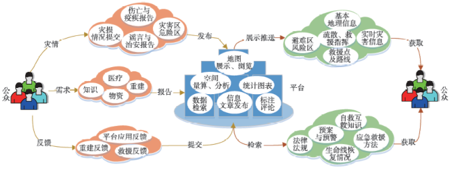
Fig. 1 Functions of the PPGIS based earthquake disaster information platform图1 基于PPGIS的地震信息平台作用 |
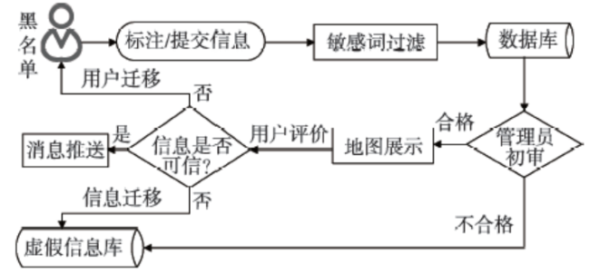
Fig. 2 Processes of user data quality control图2 用户数据质量管理流程 |
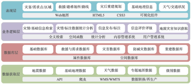
Fig. 3 Logical levels of the platform图3 系统逻辑层次 |
Tab. 2 Platform database scheme表2 平台数据库设计方案 |
| 子数据库 | 主要数据内容 |
|---|---|
| 系统数据库 | 用户、角色、权限、日志 |
| 地理数据库 | 遥感影像、地质图、医院、避难场所/路线 |
| 灾害数据库 | 地震点、次生灾害、危险区、灾害信息评价 |
| 救援数据库 | 救援点、救援路线、安置点、物资发放点、医疗点 |
| 需求数据库 | 物资需求、医疗需求、心理需求、寻人 |
| 重建数据库 | 重建规划、意见、建议、重建需求 |
| 防减灾数据库 | 建筑物等级、物资准备、演练、应急预案/规划、防减灾知识 |
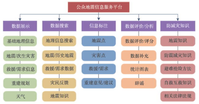
Fig. 4 Design of the function architecture图4 功能体系设计 |
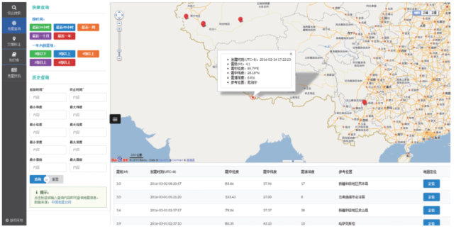
Fig. 5 Interface of earthquake information query图5 地震信息查询界面 |
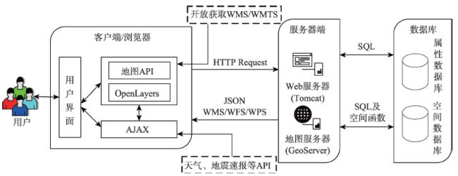
Fig. 6 Technical framework of the platform图6 平台实现技术框架 |
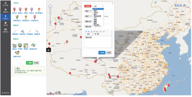
Fig. 7 Interface of information markup图7 信息标注页面 |
The authors have declared that no competing interests exist.
| [1] |
[
|
| [2] |
[
|
| [3] |
[
|
| [4] |
[
|
| [5] |
[
|
| [6] |
[Zhu C Z. The villagers here only received a few boxes of instant noodles five days after the disaster[N]. Dahe Newspaper, 2013-04-26. ]
|
| [7] |
|
| [8] |
|
| [9] |
[
|
| [10] |
|
| [11] |
|
| [12] |
|
| [13] |
|
| [14] |
|
| [15] |
|
| [16] |
[
|
| [17] |
[
|
| [18] |
[
|
| [19] |
|
| [20] |
|
| [21] |
|
| [22] |
|
| [23] |
[
|
| [24] |
|
| [25] |
[
|
| [26] |
[
|
| [27] |
[
|
| [28] |
[
|
| [29] |
|
| [30] |
|
| [31] |
[
|
| [32] |
[
|
| [33] |
[
|
| [34] |
|
| [35] |
[
|
/
| 〈 |
|
〉 |