Orginal Article

The Theory and Calculation of Spatial-spectral Cognition of Remote Sensing

  • LUO Jiancheng , 1 ,
  • WU Tianjun , 2, * ,
  • XIA Liegang 3
Expand
  • 1. State Key Laboratory of Remote Sensing Science, Institute of Remote Sensing and Digital Earth, Chinese Academy of Sciences, Beijing 100101, China
  • 2. Department of Mathematics and Information Science, College of Science, Chang’an University, Xi’an 710064
  • 3. College of Computer science and Technology, Zhejiang University of Technology, Hangzhou 310026
*Corresponding author: WU Tianjun, E-mail:

Received date: 2016-01-04

  Request revised date: 2016-03-11

  Online published: 2016-05-10

Copyright

《地球信息科学学报》编辑部 所有

Abstract

In recent years, with the rapid development of earth observation technologies, remote sensing using the satellites has gradually entered the era of big data. Facing the current demands and characteristics of remote sensing applications, it is feasible and necessary to explore the theories and methods of high-spatial-resolution remote sensing cognition with the cooperation of visual cognition. In this context, we are inspired by Geo-informatic-Tupu and intend to study the spatial-spectral cognition of remote sensing. This paper systematically presents the theory and calculation methodology for the spatial-spectral cognition of remote sensing, and expects to standardize the processes of remote sensing information extraction, as a result to further build a sophisticated, quantitative, intelligent and integrated model for the remote sensing information interpretation. The whole methodology contains two directions' cognitive calculation, namely horizontal "bottom-up hierarchical abstraction" and longitudinal "top-down knowledge transfer". These two steps are corresponded with three principal Spatial-Spectral transformation processes, which are summarized as "extracting spatial maps based on clustering pixels' spectrum", "coordinating spatial-spectral features" and "understanding attributes through the recognition of known diagram". Our study focuses on the analysis of the involved concepts, the basic idea, the key technologies and their existing difficulties, and emphasizes on the utilization of big data and gradually the application of integrated knowledge to achieve different levels of remote sensing cognition. Through these approaches, we expect to provide a new perspective for the remote sensing interpretation with the adoption of big data resources.

Cite this article

LUO Jiancheng , WU Tianjun , XIA Liegang . The Theory and Calculation of Spatial-spectral Cognition of Remote Sensing[J]. Journal of Geo-information Science, 2016 , 18(5) : 578 -589 . DOI: 10.3724/SP.J.1047.2016.00578

1 前言

随着高空间分辨率遥感(简称高分辨率遥感)卫星的大量制备,遥感卫星影像逐渐呈现出大数据的特点:(1)数据类型多元化(Variety);(2)数据时空覆盖全面,数据量骤增(Volume);(3)数据更新速度快,现势性提升(Velocity);(4)数据价值密度高(Value)。遥感大数据的价值在于蕴含其中的多尺度、全方位、动态地表信息,以及与地学、生物、人文相关等各类知识,这些往往是通过大数据整体表现出来的,需要通过认知的手段加以提炼,但遥感大数据的“4V”特征使传统的遥感数据处理和信息提取技术难以满足遥感应用的需求,特别是传统基于单景数据的信息提取很难有效地挖掘知识,限制了遥感大数据应用的价值发挥。
与一般意义上的图像认知相比,遥感认知是一种人-机-地环境下融合了遥感和地学特殊性的图像认知,在影像本身表现形式、影像处理分析方法及影像反映目标信息等方面具有一定的领域特殊性。精准化、定量化、智能化、综合化一直是其所追求的目标,但时至今日这一目标看上去仍很遥远。究其缘由是,过往的遥感认知技术往往只是将图像处理的一般性方法简单地应用于遥感这类特殊的图像上,而没有对遥感数据的时空特殊性等地理信息特性进行充分的运用。因此,大数据背景下的遥感认知要紧紧围绕遥感信息的特殊性来设计相关的算法,并合理地应用视觉认知和地学分析技术构建模型[1]
鉴于上述分析,本文在充分认识到遥感解译特殊性的基础上,综合视觉认知和地学分析的启示,试图建立可指导遥感解译的信息认知方法论——遥感图谱认知,为遥感影像的精细化、精准化、智能化、综合化认知探索可行之路。

2 视觉认知与遥感认知

2.1 视觉认知

遥感目视解译至今仍是最令人信服的遥感认知方法。要研究其中的认知过程,首先需要了解人和高等动物最重要的感觉系统——视觉系统。研究其中的视觉信息处理不仅是研究人类认知过程的最重要方面,而且也是研究人脑结构和功能的突破口[2]。20世纪中叶,诺贝尔生理和医学奖获得者Hubel和Wiesel通过对猫大脑的研究揭示了视觉系统是如何将来自外界的视觉信号传递到视皮层,并通过边界检测、运动检测、立体深度检测和颜色检测等一系列处理过程,最后在大脑中构建出一幅视觉图像[3],从此奠定了神经生理学的基础。发展至今,视觉研究的深度和广度已经发展到视觉神经科学这样一个相对独立学科的程度[4],也逐渐认识了大脑各个视觉部分是如何分解视野图像的。但不足的是,已经了解很多“认”,但对“知”还知之甚少[5]。由于视觉认知学科非常庞大,故本文仅关注与认知流程相关的学说,特别是其中涉及到信息、知识的提取和转变过程的论点或实验,以期对遥感认知流程进行指导或借鉴。
一方面,20世纪70年代末,Marr设想出一个普遍的视觉计算理论框架,用以描述视觉过程的粗略轮廓[6]。这种分层序列化的信息表达和处理思想影响深远,随着后续在外侧膝状体六层结构、视皮层功能分区等方面展开的深入研究,逐渐形成了视觉认知是自底向上的分层抽象过程的普遍共识[7]。这里的自底向上针对从数据中提取信息的加工过程而言,一般来说大脑首先从接收到的图像数据中提取形状、颜色、亮度、纹理等特征,然后根据特征识别图像中的目标内容[8-9]。分层抽象是针对从视网膜到视皮层的视觉神经过程而言,在生理上由视觉信号向认知信息的抽象过程已经被诸多实验证实,很多实验表明初级的视皮层细胞提取局部简单特征,而更高级的则提取更复杂的特征[10-12]。近年来,迅速发展的深度学习算法是对层次认知过程的计算机模拟,其主要思想是通过建立多层的非线性操作(如神经网络)来模拟特征表达,逐层抽象并最终实现对数据的有效认知[13-14]
另一方面,Crick认为,“看”是一个主动的建构过程,很多情况下视觉信息存在不足或模棱两可,但视觉认知系统却会根据其他知识主动推测,形成尽可能完整的信息或知识。例如,在遥感影像中当地物被遮挡、噪声严重时,正是这种机制使人们仍能准确地识别地物或者推测其完整边界。在这个认知过程中,先验知识起到了很大的作用,很多研究表明经验推测与视觉输入的结合可以有效地提高视觉认知的效率[15]。不同于视觉抽象过程,这种基于先验知识的认知过程通常是自顶向下的[16],而且更多情况下是作为调节反馈而非直接处理,如此才能与自底向上的前馈处理形成交互而降低认知错误,提高认知速度[17-19]。因此,若不将这种自顶向下的反馈机制和功能研究透彻,就很难完全了解视觉认知过程[20]
综合以上2方面的视觉认知流程,自底向上与自顶向下看似2个矛盾的过程,但在遥感影像的目视解译中却很好地协作着,如在识别水体、植被等地物的过程中经常以光谱特征为依据,而在识别道路、建筑物等过程中经常需要推理、匹配等步骤。一方面,这说明了2种认知流程以未被人们所了解的形式共同发挥着作用;另一方面,也表明若想更好的实现遥感影像认知,则不可避免地需要权衡这2种机制。

2.2 遥感认知

遥感认知是在掌握复杂成像机理基础上,面向应用服务,综合实现对遥感数据信息挖掘以及知识发现的环节。自20世纪90年代以来,空间认知受到地学界广泛关注和重视,遥感认知随之成为遥感信息挖掘研究领域的关键问题,主要集中在认知普遍规律、非结构化信息表达和时空推理等方面,研究方法体现为充分应用数学模型方法和人工智能技术来探索遥感数据内部结构之间及其与相关数据的有效整合与同化。总之,研究落脚点主要体现在基于空间“图形”的识别推理、基于“谱相”的参数定量反演等方面。
在遥感“图形”识别与推理方面,以模式识别理论为基点的遥感信息提取、图像分类和目标识别是遥感认知的主要表现形式,如聚类学习、神经网络分类、形状分析、纹理模型、小波分析、分形模型、空间统计模型等[21-24]。大部分传统遥感认知方法还是基于像元操作层次上的图像分析,能够描述与提取的特征非常有限,造成许多模型与方法在精度上欠缺,特别是对于高分辨率遥感影像处理与分析,其效率和精度都难以达到实际应用的需求[25]。相对地,面向对象分析方法获得了较多遥感研究者的认同[26-29],通过参考计算机视觉和认知等方法共同提高遥感自动解译的精度[30]。究其根本,像元特征分析与人们认识和描述世界的方式实际上是脱节的,难以进行领域知识、专家经验、地学模型的融合,造成方法的提取效果、应用等方面存在难以克服的局限性[31]。随后,面向对象的遥感认知也被发现存在动态特征表达的偏面性和外在知识融入的不完整,尤其缺乏针对影像地物目标及场景的分析计算模型的支持。因此,遥感认知需要综合考虑光谱、空间几何、空间关系等多种特征信息,通过学习专家对影像处理、分析和理解,模拟人对影像从视觉、记忆、联想和推理过程,达到对影像空间结构、尺度、大小、形态、单元划分、特征分布等空间和属性信息的整体性提取和描述,能够根据知识库进行高层语义逻辑分析,获得更加复杂、动态的空间分布信息,进而达到比挖掘更高层次的决策过程。
在遥感“谱相”信息综合反演方面,由于遥感起源的物理机制,遥感定量反演起源于高光谱遥感领域,也是遥感科学研究的主流。国外许多大学和研究机构(如美国马里兰大学、加州大学圣芭芭拉分校和波士顿大学等)对高光谱遥感定量反演进行了深入研究,涌现出大批知名学者,主要从大气辐射传输、植被冠层反射以及大气校正模型出发,反演地表辐射和反射参数,建立地表覆被因子提取模型和地表参数反演模型[32-35]。在国内,童庆禧院士倡导和开展了高光谱遥感研究领域,根据地物光谱特征研究发展的高光谱导数模型和光谱角度相似性匹配模型等为高光谱遥感定量化研究与应用奠定了理论基础[36]。李小文院士进一步发展了几何光学模型,对定量遥感中的病态反演本质提出了基于先验知识的多阶段反演理论[37]。在国家“973”计划支持下,李小文院士进一步开展了“地球表面时空多变要素的定量遥感理论及应用”的研究,在时空多变要素遥感模型和以先验知识为辅助的定量遥感综合反演理论方法和农林应用验证方面,进行了大量卓有成效的研究[38]
近年来,协同技术研究成为遥感认知的前沿,通过发挥多传感器在空间信息和光谱信息观测的优势,开展对地表时空特征参数的定量描述研究,以建立时空多变要素的遥感模型和以系统先验知识为辅助的遥感认知理论和方法体系。然而,由于遥感机理的复杂性以及人类对其认知的局限性,遥感认知过程中地学知识表达和融入、尺度效应和尺度转换、多源数据协同等问题仍然是目前高精度、智能化认知难以解决的难题,特别对于高分辨率遥感而言其问题更为突出。这是由于长期以来学科上的差异,造成源自物理学的“谱”分析和源自地理学的“图”理解分别进行遥感影像认知,其学术分歧至今存在,难以消除。综合看,遥感认知如果忽视了地物本身所呈现的“图”特征,空间知识就难以有效融入;遥感认知方法如果脱离了对象蕴含的“谱”意义,空间特征就难以精确计算和表达。“图-谱”分离会在一定程度上限制遥感认知的能力和水平,为此本文将发展遥感图谱认知来提升遥感信息解译水平。

3 遥感信息图谱

为使遥感认知更符合地学本质,本文在遥感认知过程中引入了陈述彭院士的地学信息图谱思想,并逐步拓展了遥感领域的信息图谱研究,提出了遥感图谱认知理论与计算的方法体系。
地学信息图谱是地图学理论研究的一个交叉性研究方向,是在陈述彭院士的倡导下发展起来的一种时空复合分析方法论[39-40]。齐清文、廖克等学者从基本理论研究、应用实践2大方面对地学信息图谱研究进行了发展,取得了诸多成果[41-42]。与此同时,他们也指出,现有的地学信息图谱研究在发展方向、新技术运用、理论研究深度等方面仍存在一些问题,急需拓展新的领域研究。本文希望实现地学信息图谱在遥感认知这一问题上的拓展和深化,将从地学信息图谱在遥感领域进行延续和延伸,探索如何参考地学图谱分析达到从遥感图像上提炼信息和知识的目的,这也是地学信息图谱研究走向高级发展阶段的必由之路。
然而,长期以来,遥感科学与地学信息图谱研究由于其产生源头的差异性,二者一直存在一定的距离感,其中的“图谱”概念也不尽相同[43]。因此,为避免歧义,本文对遥感信息的图谱概念加以阐明。
(1)遥感信息的“图”特征,是指遥感信息在地物位置、形态、结构、空间分布等属性上的表征,具有明显的区域分异性,适合结构化组织。“图特征”更倾向离散化表示,以简洁、抽象的符号形象直观地表示地理信息。如图1所示,在空间维,不同颜色为代表的地物离散分布,从宏观上可以发现区域分异规律控制下又存在明显的空间依赖关系。这种“图形”信息较好地表现了不同地物地理信息的空间属性与类型属性之间的复杂耦合关系,可表征遥感关于地物“Where”的信息,反映了不同地物的“空间分异规律”。“图”在表达尺度特性上,包含了对象/基元(最小视觉单元)、地块/目标(最小地理单元)、组团地块/目标/场景/格局(最小功能或景观单元)等层面;在空间结构尺度特性上,包含了微结构(地块内部基元相互关系)、组团结构(地块间关系)和空间格局结构(组团与组团关系)等层面。
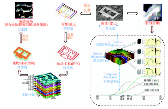
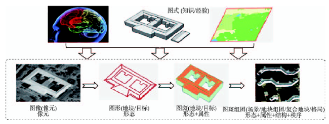
Fig. 1 Spatial-spectral explanation of remote sensing information

图1 遥感信息的图谱解释

(2)遥感信息的“谱”特征,是指遥感信息在地物光谱、时间、功能等属性上的表征,具有明显的区域相关性,适合序列化表达[42]。“谱特征”更倾向连续化表示,以序列、动态的体系定量系统地表示地理信息。如图1所示,在光谱维,地物在不同波长的反射特性可以拟合成为电磁波谱曲线;在时间维,植物在不同时相的生长特性(叶面积指数、植株高度等)可以拟合成为地物生长曲线;在功能维上,商业区、居民区、高速立交、海滩等不同功能区划区分了不同的场景和地物利用方式。上述3个方面从微观上反映了地物本身区别于其他地物的特性。这种“谱相”信息表现了不同地物在光谱、时间、功能等维度上的特点,可表征遥感关于地物“What”、“When”、“How”的信息,反映了不同地物的“内在机理”和“外在效应”。
可见,遥感影像提供了“图”与“谱”的综合信息,兼有“图形”与“谱相”的双重特性。这种图谱合一的特性是电磁波谱和空间地图的综合,共同反映了遥感地物的地理属性,揭示了不同地物在空间分异、波谱特征、时间变化、利用功能上的表现,是进行遥感认知的立足点[43]。因此,为了实现对地物“Where”、“What”、“When”、“How”等不同层次信息的认知,需从遥感认知的流程和方法上分别加以规范:在认知流程上,需参考视觉认知的计算理论和一般处理过程,以满足流程化、自动化的解译需求;在认知方法上,既需要引入模式识别、机器学习、高性能计算等其他相关学科的先进理念或技术,以满足高精度、智能化的解译需求,又要借助地学领 域的传统分析方法,以满足专业化、综合化的解译需求。

4 遥感图谱认知—三段论

遥感图谱认知模拟了人对图谱合一遥感图像的视觉认知,并受地学信息图谱启发,根据地学和高分辨率遥感特点改造而成的遥感图像理解方法体系,旨在构建精细化、定量化、智能化、综合化相结合的遥感信息认知模型。针对高分辨率遥感影像特点,整套理论与方法体系以信息为中心加工各类数据、逐层融入知识,以此图谱化推演遥感数据所反映的地物信息、地表现象、变化规律和地学认识,以期提高遥感大数据背景下的图像理解精度、效率和层次。下文将从遥感图谱认知过程中的“图谱转化”三段论对这套方法体系加以论述(图2)。
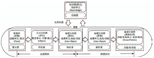
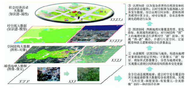
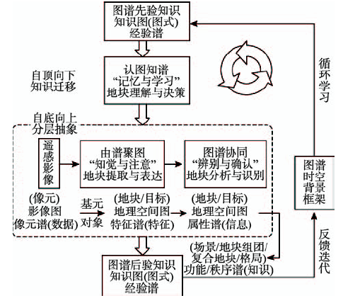
Fig. 2 The flowchart of spatial-spectral transition in the spatial-spectral cognition of remote sensing

图2 遥感图谱认知中的图谱转化

4.1 由谱聚图

“由谱聚图”是指计算像元“谱”特征,将矩阵式影像聚合为离散的地块,实现像元谱到空间图的结构转换(图3)。目的是将影像非结构化的成像单元聚合为结构化的地理单元(地块或目标),以此建立相对稳定的时空信息基准,并将其作为最小的认知单元计算各类图谱特征。这个由“图像:影像图+像元谱”→“图形:几何空间图+特征谱”→“图形:地理空间图+特征谱”的转化过程可表述为“地块的提取与表达”(像元Pixel:DN数据→对象/基元Object:形态→地块/目标Geo-object:形态),图谱特征由此产生,追求的是精细化构建由地块联接的稳定图形。
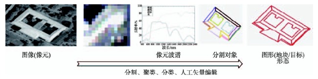
Fig. 3 Extracting spatial maps based on clustering pixels’ spectrum

图3 由谱聚图

该阶段是要回答地物在哪里(“Where”)的问题;核心内容是考虑如何利用遥感影像本身的像元波谱值等视觉特征划分出具有合理边界的地块,需从遥感影像辐射波谱特征的“谱信息”出发,结合多尺度表达技术提取精细的几何空间“图”信息,建立遥感像元波谱与地物目标几何结构的相互转化关系。该阶段是“数据 特征”的提升,是从遥感栅格数据上升到空间矢量分析的关键,强调构建合理的认知单元来表达地物,便于地物在光谱、空间、时间、环境等多个维度上的特征表征,从而更全面、客观地察觉地物特点,为准确的“图谱协同”分析做准备。该阶段的关键技术包括分割、分类人工矢量编辑等方法,常用的实现算法及存在的难点问题和发展趋势如表1所示。
Tab. 1 The key technologies and their existing difficulties they have in the stage of “extracting spatial maps based on clustering pixels’ spectrum”

表1 由谱聚图阶段的关键技术及其难点问题

关键技术 常用实现算法 存在问题与难点 发展趋势
分割 基于边缘、区域(阈值、图论、能量泛函)的多种分割算法 一般的分割算法对地物复杂多变的遥感影像适用性较低,且数据量巨大的高分影像使分割效率大幅下降,如何提升分割的效率 发展复杂环境下高分辨率影像的多尺度快速聚合技术(多尺度:大数据综合处理)
均值漂移、分水岭等多尺度分割算法 如何设置合适的尺度集来合理地表达地物的异尺度特征,实现成功抽取对象的目标[44],即如何提升分割的精度
聚类、分类 Kmeans、ISODATA等非监督分类算法的聚类,基于SVM、神经网络、决策树、随机森林等监督分类算法的像元级分类或对象级分类 像元级分类造成的椒盐噪声的影响;对象级分类受分割算法问题的影响,存在对象分离不合理的问题;对象合并规则的设定
人工矢量编辑 目视勾画 矢量编辑工具的智能化程度,减少人工操作量

4.2 图谱协同

“图谱协同”是指对空间“图”上的地块进行多维“谱”的定量渲染,实现“图-谱”耦合,以及尺度空间、定量模型和语义逻辑相结合的多重表达(图4)。目的是在地块图形的形态信息基础上加载多源定量谱信息(提升地块的特征信息维度,增强其表达描述),再结合定量模型来判别地物属性、指标及其时空变化,形成具有地学意义的地理图斑单元或其组合(具有明确地类属性的简单地块/目标:形态+属性;或具有明确地类属性的复合地块/目标:形态+属性+结构+秩序)。这个由“图形:地理空间图+特征谱”→“图斑:地理空间图+属性谱”→“图斑组团:地理空间图+属性谱+功能/秩序谱”的转化过程可表述为“地块的分析与识别”(地块/目标Geo-object:形态→地块/目标Geo-object:形态+属性→地块组团/复合地块/复合目标/场景/格局Scene/Patterns:形态+属性+结构+秩序),图谱特征在此耦合,追求的是定性化判断地块类型、定量化计算地块指标、语义化拓展地块属性。
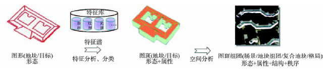
Fig. 4 Coordinating spatial-spectral features

图4 图谱协同

该阶段是要回答地物是什么(“What”)、在何时(“When”)、怎么样(“How”)的问题;核心内容是考虑如何在地块形态边界的图信息基础上将在可能收集到谱特征加载进来进行耦合分析,实现地块更新与属性扩展(材质或土壤类型、光温热气候条件、地形条件、社会经济属性等);分辨出地块的类别、结构组合、量化指标。该阶段是“特征→信息”的提升,强调以精细地块边界为基准单元,协同不同层次图谱特征完成地块属性、组合结构、量化指标及其时空演化的识别与分析,形成精确的边界和明确的属性。该阶段的关键技术包括特征提取与分析、分类等方法,也涉及了多源数据同化处理、定量模型构建或指数计算、空间分析等问题。常用的实现算法及存在的难点问题和发展趋势如表2所示。
Tab. 2 The key technologies and their existing difficulties in the stage of “coordinating spatial-spectral features”

表2 图谱协同阶段的关键技术及其难点问题

关键技术 常用实现算法 存在问题与难点 发展趋势
特征分析 光谱、空间、时间、地域等多源“图-谱”特征的提取与优选算法 地物特征的计算具有不确定性,造成后续的分类存在一定的错分率 ① 构建“影像-结构-演化”紧致结构的多特征表达模型(多特征:异构时空特征表达)
② 建立高空间、高光谱与高时间分辨率大数据协同计算(多维度:多源数据协同处理)
多时相获取的遥感数据是非平稳信号,地物特征具有不一致性,当协同时序特征时,需对数据进行有有效、可靠的滤波去噪、几何配准、辐射校正等一致性预处理
分类 SVM、神经网络、决策树、随机森林等监督分类算法以及自训练算法、生成模型、图论方法、多视角算法等半监督分类算法 地物外在特征不能描述其本质特征,典型特征难以确定,限制了分类的精细度(即地物可分性和分类精确性)[45]
训练样本的采集是费时费力的步骤,如何在少量样本或无样本条件下实现高精度的分类、提升分类的自动化与智能化程度[46]

4.3 认图知谱

“认图知谱”是指以时空框架为基准,将各类可利用知识形式化后融入到上述“由谱聚图”和“图谱协同”过程中,并综合运用空间分析、逻辑推理及模型计算等方法,对时空场景、存在态势和演化趋势进行认知,即通过辨认已有的“知识图”开展知识驱动的地物识别和专题信息定制(图5)。目的是在知识辅助下综合运用知识迁移、GIS分析、语义推理等手段来优化或提升“由谱聚图”和“图谱协同”过程中的认知,加深或加快对图像的理解,特别致力于借助外部知识来推断影像未反映或无法反映的信息,实现地物在更抽象层面的高层次专业认知,提取各类专题应用信息。这个由“图式:知识图+经验谱”→“图斑及其组团:地理空间图+属性谱+功能/秩序谱”的转化过程可表述为“地块的理解与决策”(像元Pixel:DN数据→对象/基元Object:形态→地块/目标Geo-object:形态→地块/目标Geo-object:形态+属性→复合地块/复合目标/地块组团/场景/格局Scene/Pattern:形态+属性+结构+秩序),图谱知识在此迁移,追求的是智能化、综合化认知地块特性专题,分析其自然演变和社会经济活动规律。
Fig. 5 Understanding attributes through the recognition of known diagram

图5 认图知谱

该阶段是要借助辅助知识更准确、更深入、更智能地回答地物在哪里(“Where”)、是什么(“What”)、在何时(“When”)、怎么样(“How”)的问题;核心内容是考虑如何在“由谱聚图”和“图谱协同”过程中逐步融入外部知识来提升认知的深度与广度。该阶段是“先验知识→信息”的指导,强调辅助知识自上而下的指导,往往是遥感影像本身不能反映的知识,如专家解译的历史土地覆盖图或土地利用图、规划用地图、功能区划图、空间关系图等带有较强烈语义色彩的专题图,旨在或完成复杂目标(如地块组团/复合地块等)不同层次的属性识别(如地块的土地利用属性、土地覆盖属性、功能属性、组合/格局结构等),或实现面向具体专业应用的高层次专题提取及相关决策(如简单/复合地块的合法/违章属性),或提高“由谱聚图”和“图谱协同”阶段地块提取与识别的自动化与智能化程度。该阶段的关键技术包括知识迁移、GIS空间分析、语义推理等方法。常用的实现算法及存在的难点问题和发展趋势如表3所示。
Tab. 3 The key technologies and their existing difficulties in the stage of “understanding attributes through the recognition of known diagram”

表3 认图知谱阶段的关键技术及其难点问题

关键技术 常用实现算法 存在问题与难点 发展趋势
传统地物识别技术 分割、特征提取、分类等算法 表1表2的说明 ① 建立波谱、视觉、环境和空间知识的逐步融合模型(多知识:遥感与GIS一体化)
② 发展“谱相”及“图形”间螺旋式认知的自适应计算模型(多模型:流程化、自动化)
迁移学习 实例迁移、特征迁移、参数迁移、关系知识迁移等算法 知识的形式化以及如何在不同时间、空间、尺度的先验知识中进行去伪存真以及与任务的关联
GIS空间分析 空间关系分析、叠置分析、网络分析、缓冲分析、地统计分析等算法 GIS数据与所需提取遥感信息的关联分析,以及各种GIS空间分析方法中存在的限制问题
语义推理 特征编码或表达(视觉词袋)、主题模型(概率潜语义分析pLSA、潜在狄利克雷分析LDA)、深度特征学习等算法 底层特征与高层语义间的鸿沟[8]
综上所述,遥感图谱认知就是要结合高分遥感对地物目标几何图和特征谱的双重成像优势,发展“由谱聚图-图谱协同-认图知谱”三段体系(图6):以遥感地球大数据基准影像的全覆盖有效合成处理为起始,逐步构建空间结构信息底图并精确融入时空序列大数据、社会经济活动大数据,为各行各业具有时空位置特性的大数据价值密度的提升奠定理论基础。
Fig.6 Syllogism structure in the spatial-spectral cognition of remote sensing

图6 遥感图谱认知的三段论结构

5 遥感认知计算—两步骤

在图谱认知过程中,图谱转化有其内在规律和联系,相互交织着去共同实现精细化、定量化、智能化、综合化的遥感认知目标。参照视觉认知中“分层抽象”与“经验指导”2个过程的协同作用,本文在图谱认知三段论基础上又凝练了横向和纵向2个认知计算步骤(图7)。
Fig. 7 Calculations in the spatial-spectral cognition of remote sensing

图7 遥感图谱认知计算

5.1 自底向上分层抽象(横向:对应“由谱聚图”与“图谱协同”)

自底向上分层抽象,是指对遥感数字图像抽象化的过程,这是认知过程中数据处理与分析最活跃的阶段,也是完成认知的主体步骤,追求的是精细化、精准化以及定量化的遥感认知(图8)。
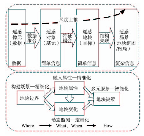
Fig.8 Hierarchical abstraction in the spatial-spectral cognition of remote sensing

图8 遥感认知计算中的分层抽象

(1)一方面是认知过程中以“像元→对象/基元地块/目标→场景/地块组团/格局”为主要载体的自底向上分层递进过程,逐步从“数据层→特征层信息层→知识层”进行抽象,语义越来越明确,对地物的认知也越来越清晰;
(2)另一方面是对应了遥感地物在认知心理过程中“知觉与注意→辨别与确认→记忆与学习”的逐步递进过程。
从图谱转化的角度来看,横向上的“自底向上分层抽象”蕴涵了“由谱聚图”和“图谱协同”2个图谱转化过程:
(1)由谱聚图,位于“自底向上分层抽象”的前端,用于提取地块边界(地块的提取与表达);在认知心理的范畴中,这个阶段是对地物的初步“知觉与注意”;
(2)图谱协同,位于“自底向上分层抽象”的后端,用于识别地块属性及变化(地块的分析与识别);在认知心理的范畴中,这个阶段是对地物的详细“辨别与确认”。

5.2 自顶向下知识迁移(纵向:对应“认图知谱”)

自顶向下知识迁移,是指收集能够为遥感认知所服务的外部辅助资料,在知识逐步融入过程中按需加工数据、提取信息,这是提升认知的关键步骤,追求的是智能化、综合化的遥感认知。一方面,强调知识在数据向信息转化过程中自顶向下的指导作用,与传统数据驱动的信息提取方法不同,这个流程需及时发现不同任务之间的相关性,识别可迁移知识的具体情境,在迁移机会出现时主动、恰当地将外部知识融入到“由谱聚图”和“图谱协同”过程中,每一阶段所使用的知识类型如表4所示;另一方面,强调在“由谱聚图”和“图谱协同”过程中的知识的实时反馈与迭代循环学习,遵循从简单到复杂,从不精确到精确,从局部到整体的逐步优化过程。人机交互就是一个在“由谱聚图”和“图谱协同”中知识逐步融入并不断迭代演进的过程,机器在接收到人目视解译提供局部的初始知识后开始学习并在不同影像区域作出判读,然后在认知错误的部分由人进行修改、补充新的知识,机器再进行重新学习,并完成新规则下的新一轮判读和结果优化,由此不断迭代循环计算,从粗到精地逐渐逼近认知真值。
Tab. 4 The form, calculation and expression of knowledge in the spatial-spectral cognition of remote sensing

表4 遥感图谱认知过程中知识的形态、计算和表达

来源 形态 表达 层次 计算 存储 迁移 应用
遥感知识 视觉知识 影像(对象)特征:色调、几何形状、纹理等波谱和和空间形态特征等 图像处理统计 对象表达特征库(表) 特征迁移 由谱聚图
参数知识 影像参数:成像时间、角度、传感器性能等 查询查阅 参数文档 参数迁移
地域知识 波谱知识 地物波谱库、纯端元地物样本库等 采集测量 波谱库(表) 特征迁移 由图聚图、
图谱协同
环境知识 坡度、坡向等DEM高程相关信息;温度、湿度等土地资源信息; 采集测量
经验总结
带有环境特征的栅格/矢量图斑、If… Then…规则 特征/关系知识迁移
解译知识 模型知识 物理量反演模型、专题指数计算模型、定理分析模型、分类体系等 实验分析
模型解算
公式、文档 参数迁移 图谱协同
物候知识 作物生长演变地学规律(季相变化物候特征)、景观格局演变规律等 时序分析 特征变化曲线 参数迁移
空间知识 空间分布 地类的地理空间分布:土地利用/覆盖解译图的图斑、空间样本位置库 目视/机器解译 带有空间位置和地类属性的栅格/矢量图斑 关系知识迁移
空间关系 阴影等相邻、相交、包含、方向等空间关系/格局知识 GIS
空间分析
语义网络、拓扑 关系知识迁移
从图谱转化的角度来看,纵向上的“自顶向下知识迁移学习”蕴涵了“认图知谱”这一图谱转化过程,用于地块的高层认知及认知的逐步趋优(地块的理解与决策);在认知心理的范畴中,这个阶段是对地物的“记忆与学习”。
综上来看,遥感图谱认知模型的完善构建应重点从以下2个层面推进:(1)设计“知觉与注意→辨别与确认→记忆与学习”的横向流程,逐层探索图谱耦合信息的表达与精炼(如高效稀疏编码、本质维表示、多粒度层次构建、语义表征等),以及多模态信息场与目标的交互转化与同化融合,结合尺度空间模型实现以“像元→对象/基元→地块/目标→场景/地块组团/格局”为流程的自底向上分层递进认知;(2)扩展外部知识在整个认知计算过程中的自顶向下纵向融入与自组织记忆机制,着重研究将不同时空背景下知识发现、形式表达(从简单规则拓宽至对象、多层深度学习网络、语义网等知识表达与运用模型)、定量评价、转换、迁移学习以及自适应迭代循环等方法。如图7所示,“由谱聚图”和“图谱协同”的横向分层抽象结果经过迭代的纵向知识融入计算,每一轮计算层级间体现多层级协同;通过“认图知谱”将外部知识学习纵向融入到横向流程中,形成后验知识又通过记忆机制迭代反馈到流程中,体现了知识协同;横向分层抽象、纵向知识融入与自组织记忆之间体现了计算协同。

6 总结与展望

在遥感大数据时代,大量堆积的现势数据与局限的陈旧信息这一矛盾变得越来越突出,遥感认知的效率、精度以及层次已经从根本上限制了遥感数据的大规模应用。本文从认知的角度出发,系统、完整地论述了遥感图谱认知理论与计算方法。综合来看,这是一套以遥感影像基本特征和机理为切入点,逐步融入外部知识并迭代逼近的遥感认知方法体系。不同于以往单景数据的处理,本文的方法体系更强调数据和辅助知识的综合利用,为遥感大数据背景下的信息解译与认知提供了新视角。
今后遥感图谱认知的工作重点可归纳为3点: (1)目前深度学习等人工智能算法在复杂的高分辨率遥感认知领域还需进一步研究,特别是如何让遥感数据与各类辅助数据紧密结合、合理地参与认知,急需探索知识的表达与推理问题,实现人工智能技术在遥感认知领域中改良和适应;
(2)在多尺度分割、迁移学习、场景识别、迭代循环等一些技术难点上仍有较大的改进余地,还需进一步设计一些创新性的实用化信息提取算法,在验证方法可行性、有效性的同时,从理论上对认知方法论加以完善;
(3)在遥感图谱认知理论框架下,要逐步向用户迫切需要的高层次影像理解延伸和侧重,面向实际应用需求生产更具实用性、更容易为用户接受的认知信息产品,使遥感卫星大数据真正服务于生产生活。

The authors have declared that no competing interests exist.

[1]
周成虎. 遥感影像地学理解与分析[M].北京:科学出版社,1999.

[ Zhou C H.Geo-understanding and analysis of remote sensing image[M]. Beijing: Science Press, 1999. ]

[2]
Crick F.The astonishing hypothesis: the scientific search for the soul[J]. The Journal of Nervous and Mental Disease, 1996,184(6):384.Partly as a side effect of the "Decade of the Brain," general readers with an interest in science have been afflicted with a surfeit of books about the brain from writers of curiously varied backgrounds. This one, with its garish title and disjointed assortment of 18 chapters, is by the distinguished codiscoverer of the structure of DNA. Some work is required to tease out of the disorderly text the two main components of the book. One of them, the better, consists of an account of current knowledge and trends of thinking about neural structure and function, with special emphasis on the cortical visual system of the higher mammals. The other component, appearing irrepressibly in bits and pieces throughout the book, as well as in longer passages, consists of a mixture of Crick's zealous and uncritical Newton-or-bust ways of thinking about the relation of consciousness to brain and an insouciant polemic,

DOI

[3]
Hubel D H, Wiesel T N.Receptive fields, binocular interaction and functional architecture in the cat's visual cortex[J]. The Journal of Physiology, 1962,160(1):106.First page of article

DOI PMID

[4]
寿天德. 视觉信息处理的脑机制(第2版)[M].合肥:中国科学技术大学出版社,2010.

[ Shou T D.The brain mechanism of visual information processing (the second edition)[M]. Hefei: University of Science & Technology China Press, 2010. ]

[5]
黄凯奇,谭铁牛.视觉认知计算模型综述[J].模式识别与人工智能,2013,26(10):951-958.视觉认知计算模型作为联系视觉认知和信息计算的有效手段,其研究涉及到认知科学、信息科学等多个交叉学科,具有复杂性和多样性等特点。为能更好地把握其发展规律,文中从视觉计算角度系统总结视觉认知计算模型,以其两个主要来源为主线分别从生物视觉机制和视觉计算理论回顾视觉认知计算模型的发展。根据其研究的特点,对视觉认知计算模型的发展做出一定评述,并指出视觉认知计算模型的发展必将对计算视觉理论和生物视觉机制产生深远影响。

[ Huang K Q, Tan T N.Review on computational model for vision[J]. Pattern Recognition and Artificial Intelligence, 2013,26(10):951-958. ]

[6]
Marr D.A computational investigation into the human representation and processing of visual information[M]. San Francisco, CA: W. H. Freeman and Company, 1982.

[7]
Konen C S, Kastner S.Two hierarchically organized neural systems for object information in human visual cortex[J]. Nature Neuroscience, 2008,11(2):224-231.The primate visual system is broadly organized into two segregated processing pathways, a ventral stream for object vision and a dorsal stream for space vision. Here, evidence from functional brain imaging in humans demonstrates that object representations are not confined to the ventral pathway, but can also be found in several areas along the dorsal pathway. In both streams, areas at intermediate processing stages in extrastriate cortex (V4, V3A, MT and V7) showed object-selective but viewpoint- and size-specific responses. In contrast, higher-order areas in lateral occipital and posterior parietal cortex (LOC, IPS1 and IPS2) responded selectively to objects independent of image transformations. Contrary to the two-pathways hypothesis, our findings indicate that basic object information related to shape, size and viewpoint may be represented similarly in two parallel and hierarchically organized neural systems in the ventral and dorsal visual pathways.

DOI PMID

[8]
Karklin Y, Lewicki M S.Emergence of complex cell properties by learning to generalize in natural scenes[J]. Nature, 2009,457(7225):83-86.A fundamental function of the visual system is to encode the building blocks of natural scenes-edges, textures and shapes-that subserve visual tasks such as object recognition and scene understanding. Essential to this process is the formation of abstract representations that generalize from specific instances of visual input. A common view holds that neurons in the early visual system signal conjunctions of image features, but how these produce invariant representations is poorly understood. Here we propose that to generalize over similar images, higher-level visual neurons encode statistical variations that characterize local image regions. We present a model in which neural activity encodes the probability distribution most consistent with a given image. Trained on natural images, the model generalizes by a compact set of dictionary elements for image distributions typically encountered in natural scenes. Model neurons show a diverse range of properties observed in cortical cells. These results provide a new functional explanation for nonlinear effects in complex cells and offer insight into coding strategies in primary visual cortex (V1) and higher visual areas.

DOI PMID

[9]
Li N, Dicarlo J J.Unsupervised natural experience rapidly alters invariant object representation in visual cortex[J]. Science, 2008,321(5895):1502-1507.Object recognition is challenging because each object produces myriad retinal images. Responses of neurons from the inferior temporal cortex (IT) are selective to different objects, yet tolerant ("invariant") to changes in object position, scale, and pose. How does the brain construct this neuronal tolerance? We report a form of neuronal learning that suggests the underlying solution. Targeted alteration of the natural temporal contiguity of visual experience caused specific changes in IT position tolerance. This unsupervised temporal slowness learning (UTL) was substantial, increased with experience, and was significant in single IT neurons after just 1 hour. Together with previous theoretical work and human object perception experiments, we speculate that UTL may reflect the mechanism by which the visual stream builds and maintains tolerant object representations.

DOI PMID

[10]
Hirabayashi T, Takeuchi D, Tamura K, et al.Microcircuits for hierarchical elaboration of object coding across primate temporal areas[J]. Science, 2013,341(6142):191-195.In primates, neuronal representations of objects are processed hierarchically in occipitotemporal cortices. A “novel” feature of objects is thought to emerge and become prevalent at a cortical area because of processing in this area. We tested the possibility that a feature representation prevalent in a given area emerges in the microcircuit of a hierarchically prior area as a small number of prototypes and then becomes prevalent in the subsequent area. We recorded multiple single units in each of hierarchically sequential areas TE and 36 of macaque temporal cortex and found the predicted convergent microcircuit for object-object association in area TE. Associative codes were then built up over time in the microcircuit of area 36. These results suggest a computational principle underlying sequentially elaborated object representations.

DOI PMID

[11]
Riesenhuber M, Poggio T.Hierarchical models of object recognition in cortex[J]. Nature Neuroscience, 1999,2(11):1019-1025.

PMID

[12]
Tanaka K.Inferotemporal cortex and object vision[J]. Annual Review of Neuroscience, 1996,19(1):109-139.Cells in area TE of the inferotemporal cortex of the monkey brain selectively respond to various moderately complex object features, and those that cluster in a columnar region that runs perpendicular to the cortical surface respond to similar features. Although cells within a column respond to similar features, their selectivity is not necessarily identical. The data of optical imaging in TE have suggested that the borders between neighboring columns are not discrete; a continuous mapping of complex feature space within a larger region contains several partially overlapped columns. This continuous mapping may be used for various computations, such as production of the image of the object at different viewing angles, illumination conditions, and articulation poses.

DOI PMID

[13]
Hinton G E.Learning to represent visual input[J]. Philosophical Transactions of the Royal Society B: Biological Sciences, 2010,365(1537):177-184.One of the central problems in computational neuroscience is to understand how the object-recognition pathway of the cortex learns a deep hierarchy of nonlinear feature detectors. Recent progress in machine learning shows that it is possible to learn deep hierarchies without requiring any labelled data. The feature detectors are learned one layer at a time and the goal of the learning procedure is to form a good generative model of images, not to predict the class of each image. The learning procedure only requires the pairwise correlations between the activations of neuron-like processing units in adjacent layers. The original version of the learning procedure is derived from a quadratic 鈥榚nergy鈥 function but it can be extended to allow third-order, multiplicative interactions in which neurons gate the pairwise interactions between other neurons. A technique for factoring the third-order interactions leads to a learning module that again has a simple learning rule based on pairwise correlations. This module looks remarkably like modules that have been proposed by both biologists trying to explain the responses of neurons and engineers trying to create systems that can recognize objects.

DOI PMID

[14]
Bengio Y, Lamblin P, Popovici D, et al.Greedy layer-wise training of deep networks[J]. Advances in Neural Information Processing Systems, 2007,19:153.Complexity theory of circuits strongly suggests that deep architectures can be much more ef cient (sometimes exponentially) than shallow architectures, in terms of computational elements required to represent some functions. Deep multi-layer neural networks have many levels of non-linearities allowing them to compactly represent highly non-linear and highly-varying functions. However, until recently it was not clear how to train such deep networks, since gradient-based optimization starting from random initialization appears to often get stuck in poor solutions. Hinton et al. recently introduced a greedy layer-wise unsupervised learning algorithm for Deep Belief Networks (DBN), a generative model with many layers of hidden causal variables. In the context of the above optimization problem, we study this algorithm empirically and explore variants to better understand its success and extend it to cases where the inputs are continuous or where the structure of the input distribution is not revealing enough about the variable to be predicted in a supervised task. Our experiments also confirm the hypothesis that the greedy layer-wise unsupervised training strategy mostly helps the optimization, by initializing weights in a region near a good local minimum, giving rise to internal distributed representations that are high-level abstractions of the input, bringing better generalization.

[15]
Bar M.The proactive brain: using analogies and associations to generate predictions[J]. Trends in Cognitive Sciences, 2007,11(7):280-289.<p id="simple-para0045">Rather than passively &lsquo;waiting&rsquo; to be activated by sensations, it is proposed that the human brain is continuously busy generating predictions that approximate the relevant future. Building on previous work, this proposal posits that rudimentary information is extracted rapidly from the input to derive analogies linking that input with representations in memory. The linked stored representations then activate the associations that are relevant in the specific context, which provides focused predictions. These predictions facilitate perception and cognition by pre-sensitizing relevant representations. Predictions regarding complex information, such as those required in social interactions, integrate multiple analogies. This cognitive neuroscience framework can help explain a variety of phenomena, ranging from recognition to first impressions, and from the brain's &lsquo;default mode&rsquo; to a host of mental disorders.</p>

DOI

[16]
Engel A K, Fries P, Singer W.Dynamic predictions: oscillations and synchrony in top-down processing[J]. Nature Reviews Neuroscience, 2001,2(10):704-716.Abstract Classical theories of sensory processing view the brain as a passive, stimulus-driven device. By contrast, more recent approaches emphasize the constructive nature of perception, viewing it as an active and highly selective process. Indeed, there is ample evidence that the processing of stimuli is controlled by top-down influences that strongly shape the intrinsic dynamics of thalamocortical networks and constantly create predictions about forthcoming sensory events. We discuss recent experiments indicating that such predictions might be embodied in the temporal structure of both stimulus-evoked and ongoing activity, and that synchronous oscillations are particularly important in this process. Coherence among subthreshold membrane potential fluctuations could be exploited to express selective functional relationships during states of expectancy or attention, and these dynamic patterns could allow the grouping and selection of distributed neuronal responses for further processing.

DOI PMID

[17]
Melloni L, van Leeuwen S, Alink A, et al. Interaction between bottom-up saliency and top-down control: how saliency maps are created in the human brain[J]. Cerebral Cortex, 2012,22(12):2943-2952.Whether an object captures our attention depends on its bottom-up salience, that is, how different it is compared with its neighbors, and top-down control, that is, our current inner goals. At which neuronal stage they interact to guide behavior is still unknown. In a functional magnetic resonance imaging study, we found evidence for a hierarchy of saliency maps in human early visual cortex (V1 to hV4) and identified where bottom-up saliency interacts with top-down control: V1 represented pure bottom-up signals, V2 was only responsive to top-down modulations, and in hV4 bottom-up saliency and top-down control converged. Two distinct cerebral networks exerted top-down control: distractor suppression engaged the left intraparietal sulcus, while target enhancement involved the frontal eye field and lateral occipital cortex. Hence, attentional selection is implemented in integrated maps in visual cortex, which provide precise topographic information about target-distractor locations thus allowing for successful visual search.

DOI PMID

[18]
Navalpakkam V, Itti L.An integrated model of top-down and bottom-up attention for optimizing detection speed[C]. 2006 IEEE Computer Society Conference on Computer Vision and Pattern Recognition, 2006:2049-2056.

[19]
Friston K.A theory of cortical responses[J]. Philosophical Transactions of the Royal Society B: Biological Sciences, 2005,360(1456):815-836.CiteSeerX - Scientific documents that cite the following paper: A theory of cortical responses

DOI

[20]
Kveraga K, Ghuman A S, Bar M.Top-down predictions in the cognitive brain[J]. Brain and cognition, 2007,65(2):145-168.<h2 class="secHeading" id="section_abstract">Abstract</h2><p id="">The human brain is not a passive organ simply waiting to be activated by external stimuli. Instead, we propose that the brain continuously employs memory of past experiences to interpret sensory information and predict the immediately relevant future. The basic elements of this proposal include analogical mapping, associative representations and the generation of predictions. This review concentrates on visual recognition as the model system for developing and testing ideas about the role and mechanisms of top-down predictions in the brain. We cover relevant behavioral, computational and neural aspects, explore links to emotion and action preparation, and consider clinical implications for schizophrenia and dyslexia. We then discuss the extension of the general principles of this proposal to other cognitive domains.</p>

DOI

[21]
Iounousse J, Er-Raki S, Chehouani H.Using an unsupervised approach of probabilistic neural network (PNN) for land use classification from multitemporal satellite images[J]. Applied Soft Computing, 2015,30:1-13.

[22]
Demir B, Erturk S.Clustering-based extraction of border training patterns for accurate SVM classification of hyperspectral images[J]. IEEE Transactions on Geoscience and Remote Sensing Letters, 2009,6(4):840-844.This letter presents an accurate support vector machine (SVM)-based hyperspectral image classification algorithm, which uses border training patterns that are close to the separating hyperplane. Border training patterns are obtained in two consecutive steps. In the first step, clustering is performed to training data of each class, and cluster centers are taken as initial training data for SVM. In the second step, the reduced-size training data composed of cluster centers are used in SVM training, and cluster centers obtained as support vectors at this step are regarded to be located close to the hyperplane border. Original training samples are contained in clusters for which the cluster centers are obtained to be close to the hyperplane border and the corresponding cluster centers are then together assigned as border training patterns. These border training patterns are then used in the training of the SVM classifier. Experimental results show that it is possible to significantly increase the classification accuracy of SVM using border training patterns obtained with the proposed approach.

DOI

[23]
Knight A, Tindall D, Wilson B.A multitemporal multiple density slice method for wetland mapping across the state of Queensland, Australia[J]. International Journal of Remote Sensing, 2009,30(13):3365-3392.The Australian and Queensland Governments are developing comprehensive wetland maps at a scale of 1:100聽000 for the state of Queensland, Australia. Spectral classifications for water features were developed using Landsat Thematic Mapper (TM) and Enhanced Thematic Mapper (ETM+) imagery acquired over a 16-year period. A multiple density slice/supervised classification method, the Standing Water Body (SWB) method, was developed to separate the main spectral and land cover elements of wetlands (vegetation, water and shadow cast by vegetation and topographic relief) and used rules to combine spectral classes to provide multitemporal (MT) information on wetland extent and water inundation regimes for features of at least 0.25 ha. Accuracy assessment in four trial areas compared the SWB method to the Normalized Difference Water Index (NDWI). The assessments of classified features were scale adjusted to maximum class-area proportions to enable statistical comparison and to account for the large area of non-wetland in the four trial areas. The average overall accuracy for wetland classification was 95.9% for the SWB method and 95.3% for the NDWI. The average unadjusted KHAT statistic for the wetland classification was 0.84 and 0.90 for the SWB and NDWI, respectively. The scale-adjusted KHAT statistic was much lower for both methods, averaging 0.45 for the SWB and 0.39 for the NDWI, mainly due to large omission errors. A method for the implementation of the SWB method for systematic and repeatable mapping of wetland areas is presented. The study recommends enhancement of the SWB classification through the inclusion of the NDWI classification and ancillary data such as vegetation mapping and drainage networks.

DOI

[24]
Giada S, De Groeve T, Ehrlich D, et al.Information extraction from very high resolution satellite imagery over Lukole refugee camp, Tanzania[J]. International Journal of Remote Sensing, 2003,24(22):4251-4266.This paper addresses information extraction from IKONOS imagery over the Lukole refugee camp in Tanzania. More specific, it describes automatic image analysis procedures for a rapid and reliable identification of refugee tents as well as their spatial extent. From the identified tents, the number of refugees can be derived and a map of the camp can be generated, which can be used for improving refugee camp management. Four information extraction methods have been tested and compared: supervised classification, unsupervised classification, multi-resolution segmentation and mathematical morphology analysis. The latter two procedures based on object-oriented classifiers perform best with a spatial accuracy above 85% and a statistical accuracy above 97%. These methods could be used for refugee camp information extraction in other geographical settings and on imagery with different spatial and spectral resolutions.

DOI

[25]
Song M, Civco D, Hurd J.A competitive pixel-object approach for land cover classification[J]. International Journal of Remote Sensing, 2005,26(22):4981-4997.

[26]
Zhou Y, Qiu F.Fusion of high spatial resolution WorldView-2 imagery and LiDAR pseudo-waveform for object-based image analysis[J]. ISPRS Journal of Photogrammetry and Remote Sensing, 2015,101:221-232.High spatial resolution (HSR) imagery and high density LiDAR data provide complementary horizontal and vertical information. Therefore, many studies have focused on fusing the two for mapping geographic features. It has been demonstrated that the synergetic use of LiDAR and HSR imagery greatly improves classification accuracy. This is especially true with waveform LiDAR data since they provide more detailed vertical profiles of geographic objects than discrete-return LiDAR data. Fusion of discrete-return LiDAR and HSR imagery mostly takes place at the object level due to the superiority of object-based image analysis (OBIA) for classifying HSR imagery.

DOI

[27]
Li X, Shao G.Object-based land-cover mapping with high resolution aerial photography at a county scale in midwestern USA[J]. Remote Sensing, 2014,6(11):11372-11390.

[28]
Voltersen M, Berger C, Hese S, et al.Object-based land cover mapping and comprehensive feature calculation for an automated derivation of urban structure types at block level[J]. Remote Sensing of Environment, 2014,154:192-201.ABSTRACT Cities have evolved under manifold geographical, economical, historical, and cultural criteria, resulting in various sizes and shapes. Each city exhibits individual features and unique characteristics, despite that structural similarities appear. The separation into individual patterns, commonly named urban structure types (USTs), supports the characterization of physical, functional, and energetic factors of settlement structures, enabling associated environmental and socio-economic investigations as well as the comparison between the patterns of different cities. This study presents an automated approach for the classification of USTs based on remote sensing data in order to analyze the links between settlement structures and environmental issues, such as air pollution or urban heat islands, in a later stage of the project. Initially, an object-based classification routine is implemented to identify the land cover for the city of Berlin, utilizing spatially very high resolution aerial images and object height information. UST classes are defined based on the occurrence within the study area and are delimited by block boundaries. Afterwards, indicators for the derivation of USTs are generated based on the previously derived land cover information and the most valuable features are selected with the help of Random Forests. Finally, structural units are classified, involving common and new land cover based parameters. The focus is on the generation of an automated and transferable routine for a comprehensive UST classification covering the entire city. Comparing the results with reference data, good classification accuracies for both land cover and USTs indicate the suitability of the proposed method.

DOI

[29]
Blaschke T.Object based image analysis for remote sensing[J]. ISPRS Journal of Photogrammetry and Remote Sensing, 2010,65(1):2-16.<h2 class="secHeading" id="section_abstract">Abstract</h2><p id="">Remote sensing imagery needs to be converted into tangible information which can be utilised in conjunction with other data sets, often within widely used Geographic Information Systems (GIS). As long as pixel sizes remained typically coarser than, or at the best, similar in size to the objects of interest, emphasis was placed on per-pixel analysis, or even sub-pixel analysis for this conversion, but with increasing spatial resolutions alternative paths have been followed, aimed at deriving objects that are made up of several pixels. This paper gives an overview of the development of object based methods, which aim to delineate readily usable objects from imagery while at the same time combining image processing and GIS functionalities in order to utilize spectral and contextual information in an integrative way. The most common approach used for building objects is image segmentation, which dates back to the 1970s. Around the year 2000 GIS and image processing started to grow together rapidly through object based image analysis (OBIA - or GEOBIA for geospatial object based image analysis). In contrast to typical Landsat resolutions, high resolution images support several scales within their images. Through a comprehensive literature review several thousand abstracts have been screened, and more than 820 OBIA-related articles comprising 145 journal papers, 84 book chapters and nearly 600 conference papers, are analysed in detail. It becomes evident that the first years of the OBIA/GEOBIA developments were characterised by the dominance of &lsquo;grey&rsquo; literature, but that the number of peer-reviewed journal articles has increased sharply over the last four to five years. The pixel paradigm is beginning to show cracks and the OBIA methods are making considerable progress towards a spatially explicit information extraction workflow, such as is required for spatial planning as well as for many monitoring programmes.</p>

DOI

[30]
宫鹏,黎夏,徐冰.高分辨率影像解译理论与应用方法中的一些研究问题[J].遥感学报,2006,10(1):1-5.近年来,不断发展的遥感技术使遥感数据呈现出高空间分辨率、高光谱分辨率和高时间采集频率的特点。卫星图像空间分辨率已经提高到0.6m级,而航空遥感数字影像分辨率高达0.1m以上。光谱分辨率高达3―4nm。不断发展的高分辨率遥感数据能够提高信息提取和监测精度,并拓展遥感数据的应用范围。目前,国外已经加快对高分辨率图像,特别是高空间分辨率影像,在城市环境、精准农业、交通及道路设施、林业测量、军事目标识别和灾害评估中的应用。但是总的情况是自动化程度不高。介绍高空间分辨率影像信息提取、高光谱和偏振影像信息提取、影像数据融合和高分辨率遥感变化探测等方面迫切需要研究的一些科学问题及其意义。建议建立图像知识库,改善数据共享环境,为有志于从事这方面研究的学者提供参考。

DOI

[ Gong P, Li X, Xu B.Interpretation theory and application method development for information extraction from high resolution remotely sensed data[J]. Journal of Remote Sensing, 2006,10(1):1-5. ]

[31]
明冬萍,骆剑承,沈占锋,等.高分辨率遥感影像信息提取与目标识别技术研究[J]. 测绘科学, 2005,30(3):18-20.由于高空间分辨率遥感影像海量数据、复杂细节和尺度依赖的特点决 定了高分辨率遥感影像处理的技术难点.在总结以往高分辨率影像(航空影像)信息提取技术的主要难点和不足,从理论上和实践上分析了基于特征基元的高分辨率 遥感影像处理与分析的意义,提出了基于特征基元的高分辨率遥感影像多尺度信息提取技术框架.最后对此框架进行总结与分析,指出了目前研究中仍存在的难点和 今后的研究重点.

DOI

[ Ming D P, Luo J C, Shen Z F, et al.Research on information extraction and target recognition from high resolution remote sensing image[J]. Science of Surveying and Mapping, 2005,30(3):18-20. ]

[32]
Liang S.Quantitative remote sensing of land surfaces[M]. New Jersey: John Wiley & Sons, 2005.

[33]
Li X, Strahler A H.Geometric-optical bidirectional reflectance modeling of the discrete crown vegetation canopy: effect of crown shape and mutual shadowing[J]. IEEE Transactions on Geoscience and Remote Sensing, 1992,30(2):276-292.ABSTRACT In the case where a vegetation cover can be regarded as a collection of individual, discrete plant crowns, the geometric-optical effects of the shadows that the crowns cast on the background and on one another strongly condition the brightness of the vegetation cover as seen from a given viewpoint in the hemisphere. An asymmetric hotspot, in which the shape of the hotspot is related to the shape of the plant crowns in the scene, is created. At large zenith angles illumination shadows will preferentially shadow the lower portions of adjacent crowns. Further, these shadows will be preferentially obscured since adjacent crowns will also tend to obscure the lower portions of other crowns. This effect produces a `bowl-shaped' bidirectional reflectance distribution function (BRDF) in which the scene brightness increases at the function's edges. Formulas describing the hotspot and mutual-shadowing effects are derived, and examples that show how the shape of the BRDF is dependent on the shape of the crowns, their density, their brightness relative to the background, and the thickness of the layer throughout which the crown centers are distributed are presented

DOI

[34]
Jupp D L, Strahler A H.A hotspot model for leaf canopies[J]. Remote Sensing of Environment, 1991,38(3):193-210.

[35]
Nilson T, Kuusk A.A reflectance model for the homogeneous plant canopy and its inversion[J]. Remote Sensing of Environment, 1989,27(2):157-167.An analytical reflectance model for a statistically homogeneous plant canopy has been developed. The most specific characteristics of the model are: 1) considering both the single and the multiple scattering of radiation in the canopy and on the soil and 2) accounting for the specular reflection of radiation on leaves and canopy hot spot. For the inversion of the model the technique suggested by Goel and Strebel (1983) has been applied. The reflectance model fits well the results of measurements both of the seasonal course of the nadir reflectance and of the angular distribution of the directional reflectance of the winter wheat and barley canopies.

DOI

[36]
童庆禧,张兵,郑兰芬.高光谱遥感:原理,技术与应用[M].北京:高等教育出版社,2006.

[ Tong Q X, Zhang B, Zhen L F.Hyperspectral remote sensing: principle, technology and application[M]. Beijing: Higher Education Press, 2006. ]

[37]
李小文,王绵地.植被光学遥感模型与植被结构参数化[M].北京:科学出版社,1995.

[ Li X W, Wang J D.Optical remote sensing model of vegetation and structure parameterization of vegetation[M]. Beijing: Science Press, 1995. ]

[38]
李小文. 地球表面时空多变要素的定量遥感项目综述[J].地球科学进展,2006,21(8):771-780.<p>对&ldquo;973&rdquo;项目&ldquo;地球表面时空多变要素的定量遥感理论及应用&rdquo;的研究工作做了综述,介绍了项目研究的科学背景、总体科学思路、研究内容和科学目标。项目经过5年的努力,在尺度效应和尺度转换理论、基于先验知识的定量遥感反演理论、同步观测和模拟试验等方面取得了一系列研究成果;成功实现了遥感模型与农学、生态学等应用模型的链接,并在精准农业、西北草场生态建设中进行了成功应用。</p>

[ Li X W.Review of the project of quantitative remote sensing of major factors for spatial-temporal heterogeneity on the land surface[J]. Advances in Earth Science, 2006,21(8):771-780. ]

[39]
陈述彭. 地学信息图谱探索研究[M].北京:科学出版社,2001.

[ Chen S P.Exploratory research on geo-informatic Tupu[M]. Beijing: Science Press, 2001. ]

[40]
陈述彭,岳天祥,励惠国.地学信息图谱研究及其应用[J].地理研究,2000,19(4):337-343.地学信息图谱综合了景观综合图的简洁性和数学模型的抽象性,它是现代空间技术与我国传统研究成果结合的产物,它可反演过去、预测未来。在分析地学信息图谱、生态系统发展战略、DLU土地利用战略、数学模型与地理信息系统集成等研究成果的基础上,提出了一个区域可持续发展虚拟系统。在这个虚拟系统中,如何将区域可持续发展的有关信息转换为征兆图、诊断图和实施图是其核心理论问题。数学模型计算机程序自动生成软件和开放式地理信息系统的研究成果表明,这些理论问题在不久的将来是可以解决的。也就是说,这个区域可持续发展虚拟系统的进一步研究,能够形成一个可操作的、实用的决策支持系统。

[ Chen S P, Yue T X, Li H G.Studies on geo-informatic Tupu and its application[J]. Geographical Research, 2000,19(4):337-343. ]

[41]
齐清文,池天河.地学信息图谱的理论与方法研究[J].地理学报,2001,56(z1):8-18.

[ Qi Q W, Chi T H.Research on the theory and method of geo-informatic Tupu[J]. Geographical Research, 2001,56(z1):8-18. ]

[42]
廖克. 地学信息图谱的探讨与展望[J].地球信息科学,2002,4(2):14-20.

[ Liao K.The discussion and prospect for geo-informatic Tupu[J]. Geo-information Science, 2002,4(2):14-20. ]

[43]
骆剑承,周成虎,沈占锋,等.遥感信息图谱计算的理论方法研究[J].地球信息科学学报,2009,11(5):5664-5669.遥感应用的本质是投入专业知识从对地观测影像中提炼专题信息,并以之服务于各类分析与决策的过程。其中,信息计算是整个遥感应用服务技术链的基底。本文在传承地学信息图谱理论的基础上,提出了遥感"图-谱"信息耦合的空间认知理论,构建了"像元—基元—目标—格局"为一体的遥感信息图谱计算的理论方法体系,将其分为"像元级"和"对象级"两个层次,并阐述了高性能计算环境支持下,遥感信息图谱计算平台的设计开发思路及目前研发进展,总结了遥感信息图谱计算的发展趋势和重点研究问题。

DOI

[ Luo J C, Zhou C H, Shen Z F, et al.Theoretic and methodological review on sensor information Tupu computation[J]. Journal of Geo-information Science, 2009,11(5):5664-5669. ]

[44]
李德仁,童庆禧,李荣兴,等.高分辨率对地观测的若干前沿科学问题[J].中国科学:地球科学,2012,42(6):805-813.简要回顾了国际高分辨率对地观 测领域近十年来的发展,介绍了我国高分辨率对地观测领域发展的现状与规划,系统论述了从观测数据到空间信息和地学知识自动转化的机理与过程,归纳凝练出对 地观测传感网、高精度自主定位、影像理解与信息提取和聚焦服务等方面急需解决的关键科学技术问题,为我国高分辨率对地观测系统从"量"到"质"、从面向中 国到面向全球、从提供产品到提供服务的转变提出了思路.

DOI

[ Li D R, Tong Q X, Li R X, et al.Some frontier science problems of high-resolution earth observation[J]. Science China: Earth Sciences, 2012,42(6):805-813. ]

[45]
孙显,付琨,王宏琦.高分辨率遥感图像理解[M].北京:科学出版社,2011.

[ Sun X, Fu K, Wang H Q.High resolution remote sensing image understanding[M]. Beijing: Science Press, 2011. ]

[46]
吴田军,骆剑承,夏列钢,等.迁移学习支持下的遥感影像对象级分类样本自动选择方法[J].测绘学报,2014,43(9):903-916.面向遥感大范围应用的目标,自动化程度仍是遥感影像分类面临的重要问题,样本的人工选择难以适应当前土地覆盖信息自动化提取的实际应用需求。为了构建一套基于先验知识的遥感影像全自动分类流程,本文将空间信息挖掘技术引入到遥感信息提取过程中,提出一种面向遥感影像对象级分类的样本自动选择方法。该方法通过变化检测将不变地物标示在新的目标影像上,并将过去解译的地物类别知识迁移至新的影像上,建立新的特征与地物关系,从而完成历史专题数据辅助下目标影像的自动化对象级分类。试验结果表明,在已有历史专题层的图斑知识指导下,该方法能有效地自动选择适用于新影像分类的可靠样本,获得较好的信息提取效果,提高了对象级分类的效率。

DOI

[ Wu T J, Luo J C, Xia L G, et al.An automatic sample collection method for object-oriented classification of remotely sensed imageries based on transfer learning[J]. Acta Geodaetica et Cartographica Sinica, 2014,43(9):908-916. ]

Outlines

/