
Journal of Geo-information Science >
Optimal Scales Based Segmentation of High Spatial Resolution Remote Sensing Data
Received date: 2016-02-15
Request revised date: 2016-04-18
Online published: 2016-05-10
Copyright
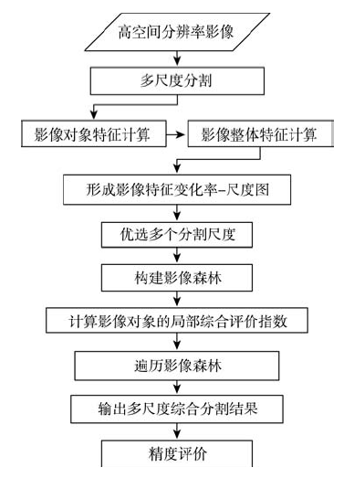
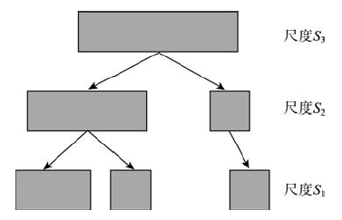
The quality of image segmentation has a great impact on the results of information extraction from high spatial resolution remote sensing imagery when the object-based method is employed. During the segmentation of high spatial resolution remote sensing images, the scale parameter directly affects the construction of segmented image objects. A small scale is likely to produce broken image objects, while a large scale probably results in the mixed image objects. To solve this problem, an image segmentation framework based on a set of optimal scales is proposed in this paper. First of all, the high spatial resolution remote sensing image is processed using multi-scale segmentation methods with respect to a group of regularly distributed scales. Then the relationship between the global standard deviation of a single segmented layer and its corresponding scale is determined, from which a group of optimal scales are selected. Since the object in a layer that is segmented by a big scale parameter contains the corresponding object in a layer that is segmented by a small scale parameter, a hierarchical tree with nodes of multi-scale image objects can be created. Within this hierarchical tree, the image object of the layer that is segmented by the maximum scale is set as the root. In this manner, each image object of the layer that is segmented by the maximum scale can generate a hierarchical tree, which all together forms the image forest. Two types of features are considered when the optimal image object is selected from each hierarchical tree, which are the comprehensive evaluation index and the spectral features. The comprehensive evaluation index keeps a balance between the homogeneity and heterogeneity of the image objects. And the spectral features of the children nodes should be consistent with the parent nodes in order to dismiss the mixed image objects. Finally, the segmented result is created after the optimal image objects from all hierarchical trees are selected. In the experiment presented in this paper, the Geoeye and ZY3 images are adopted. Results show that the proposed method can effectively improve the percentage of properly segmented image objects.
YANG Haiping , MING Dongping . Optimal Scales Based Segmentation of High Spatial Resolution Remote Sensing Data[J]. Journal of Geo-information Science, 2016 , 18(5) : 632 -638 . DOI: 10.3724/SP.J.1047.2016.00632
Fig.1 Process of image segmentation based on a series of optimal scales图1 基于多层优选尺度的高分影像分割方法 |
Fig.2 Diagram of a hierarchical tree with nodes of multiscale image objects图2 多层次对象树示意图 |
Fig.3 Geoeye multispectral image图3 Geoeye多光谱影像 |
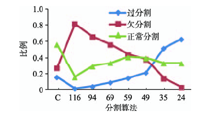
Fig.4 Comparison of the segmentation results using different methods for the Geoeye multispectral image图4 Geoeye多光谱影像分割实验中不同尺度分割结果和本文方法分割结果的精度比较 |
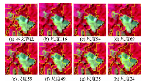
Fig.5 Details of the segmentation results for the Geoeye multispectral image图5 Geoeye多光谱影像分割实验的局部结果图 |
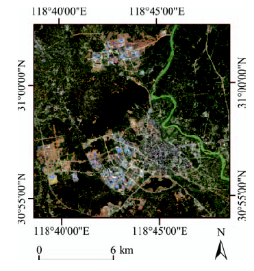
Fig.6 ZY3 multispectral image图6 ZY3影像 |
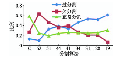
Fig.7 Comparison of the segmentation results using different methods for the ZY3 multispectral image图7 ZY3多光谱影像分割实验中不同尺度分割结果和本文方法分割结果的精度比较 |
Fig.8 Details of the segmentation results of factory buildings for the ZY3 multispectral image图8 ZY3多光谱影像分割实验的局部结果图 |
The authors have declared that no competing interests exist.
| [1] |
|
| [2] |
|
| [3] |
|
| [4] |
|
| [5] |
|
| [6] |
|
| [7] |
|
| [8] |
|
| [9] |
[
|
| [10] |
[
|
| [11] |
|
| [12] |
|
| [13] |
|
| [14] |
[
|
| [15] |
eCognition Developer. eCognition developer 8.7: reference book[M]. Munich, Germany: Trimble Germany GmbH, 2011.
|
| [16] |
[
|
| [17] |
|
| [18] |
[
|
| [19] |
[
|
| [20] |
[
|
| [21] |
|
/
| 〈 |
|
〉 |

