
Journal of Geo-information Science >
Remotely Sensed Land Patch Classification by Collaborating with Multi-Resolution Data
Received date: 2015-12-15
Request revised date: 2016-03-14
Online published: 2016-05-10
Copyright
The obtaining of remotely sensed imagery may affected by design of satellite, sensors, and atmospheric conditions.Normally it is difficult to balance the temporal and spatial resolution. Which leads to the hard of information extraction from a single source remote sensing data.Obviously this may impossible to meet the application demand which ask for higher and higher resolution information on spatial and temporal. Considering the different advantages of multi-source data and the accumulation of the multi-temporal data by time,we design the classification method based on the patches for multi-source data. The patches are basic geographical units which are relatively stable on boundary and properties. With these patches, other data may reflect the spectrum performance at different time or different point of view. After calculating these features we can interpret the patches with adapt methods based on the characteristics of each land class.In the land use classification experiment of Maduo in summer of 2014, many data are collecting for cooperating classification. Long term middle resolution data cover the whole vegetation growing season and cloudless high resolution data in winter are used after solving the problem of geo-matching and multi-source compositing. Because of different advantages of these data, categories like built up, water, vegetation are interpreted separately. At last we get a high total accuracy. Not only effectively overcome the traditional perspective of insufficient data source, lack of information and complete the interpretation of the county.But also ensure the spatial and temporal resolution of land information.
XIA Liegang , WANG Weihong , YANG Haiping . Remotely Sensed Land Patch Classification by Collaborating with Multi-Resolution Data[J]. Journal of Geo-information Science, 2016 , 18(5) : 649 -654 . DOI: 10.3724/SP.J.1047.2016.00649
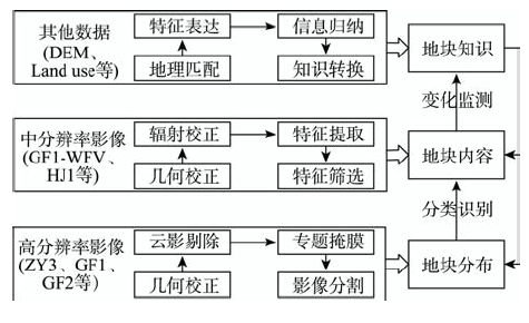
Fig. 1 Flowchart ofthe collaborative field classification formulti-resolution data图1 多分辨率数据协同地块分类流程 |
Tab. 1 Statistics of the remote sensing data used in this study表1 遥感数据统计表 |
| 数据类型 | 分辨率/m | 时相 | 数量/景 | 数据量/GB |
|---|---|---|---|---|
| ZY3融合 | 2 | 2013、2014冬季 | 37 | 190 |
| GF1融合 | 2 | 2014年6-9月 | 21 | 81.9 |
| GF1-WFV | 16 | 2014年6-9月 | 26 | 60.8 |
| Landsat8 | 30 | 2014年6-9月 | 9 | 10.5 |
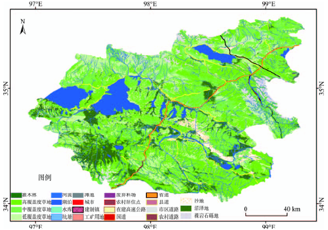
Fig. 2 Land use map of Maduo county in Qinghai Province图2 青海省玛多县土地利用图 |
Tab. 2 Maduo county land use classification表2 玛多县土地利用分类精度表 |
| 类别 | 人工用地 | 草地 | 河流 | 湖泊 | 沙地 | 沼泽地 | 裸岩石砾地 | 生产精度/(%) | |
|---|---|---|---|---|---|---|---|---|---|
| 人工用地 | 39 | 0 | 0 | 0 | 0 | 0 | 0 | 100.0 | |
| 草地 | 1 | 169 | 2 | 0 | 1 | 2 | 1 | 96.0 | |
| 河流 | 0 | 3 | 56 | 1 | 0 | 1 | 0 | 91.8 | |
| 湖泊 | 0 | 1 | 1 | 68 | 0 | 1 | 0 | 95.8 | |
| 沙地 | 0 | 1 | 0 | 0 | 17 | 0 | 0 | 94.4 | |
| 沼泽地 | 0 | 6 | 1 | 1 | 0 | 16 | 0 | 66.7 | |
| 裸岩石砾地 | 0 | 0 | 0 | 0 | 2 | 0 | 9 | 81.8 | |
| 用户精度/(%) | 97.5 | 93.9 | 93.3 | 97.1 | 85.0 | 80.0 | 90.0 | ||
| 总体精度/(%) | 93.5 | ||||||||
| kappa系数 | 0.911 |
The authors have declared that no competing interests exist.
| [1] |
|
| [2] |
|
| [3] |
|
| [4] |
|
| [5] |
|
| [6] |
|
| [7] |
|
| [8] |
|
| [9] |
|
| [10] |
|
| [11] |
|
| [12] |
|
| [13] |
[
|
| [14] |
|
| [15] |
|
| [16] |
[
|
| [17] |
[
|
| [18] |
|
/
| 〈 |
|
〉 |