
Journal of Geo-information Science >
Water Information Extraction of Baiyangdian Wet Land Based on the Collaborative Computing Method
Received date: 2015-12-15
Request revised date: 2016-02-22
Online published: 2016-05-10
Copyright
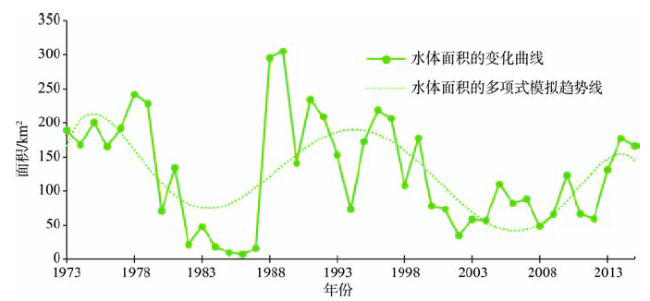
Baiyangdian wetland is one of the very few remaining wetlands in north China, which has the functions of improving the ecological environment, maintaining the conservation of biological diversity and so on. It has the very prominent significance to researches that are focusing on the wetland changes in this area, because these researches can provide an important information support under the assistance of remote sensing to investigate the change of landscape pattern and conduct the environmental analysis. Remote sensing big data has become a trend for the development of remote sensing technology. Based on the characteristics of remote sensing big data, this paper analyzes the big data extraction technology, which is a critical part in the remote sensing applications. In addition, starting with the calculation of remote sensing information, this paper summarizes various collaborative computing problems encountered during the process of remote sensing big data calculation. Considering the application requirements of wetland water body extraction and change analysis over a long time period in Baiyangdian, this paper proposes a method based on the collaborative computing technology to extract the water body in Baiyangdian. The method firstly computes the initial NDWI threshold in its histogram and finds the possible lakes within the region, and then it computes the suitable GNDWI for every lake to implement the precise lake extraction one by one. And at last, several typical types of collaborative computing problems are analyzed in this procedure. According to the water extraction result from our analysis on a period between 1973 and 2015, we study the historical water area changes of Baiyangdian, and the results show that the water area in this region has experienced a “decrease-increase-another decrease-another increase” changing pattern.
SHEN Zhanfeng , LI Junli , YU Xinju . Water Information Extraction of Baiyangdian Wet Land Based on the Collaborative Computing Method[J]. Journal of Geo-information Science, 2016 , 18(5) : 690 -698 . DOI: 10.3724/SP.J.1047.2016.00690
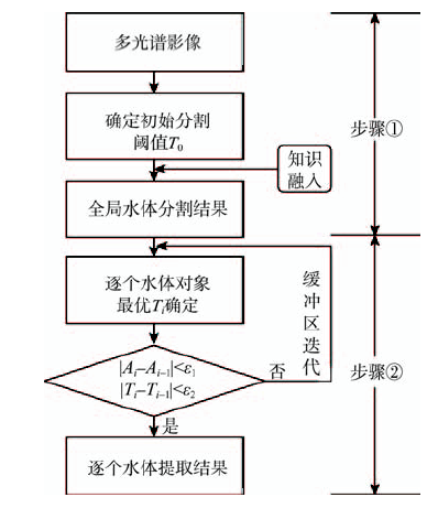
Fig. 1 Water extraction method for the Baiyangdian region图1 白洋淀地区水体提取技术路线图 |
Tab. 1 Data used for water extraction and their acquisition time表1 白洋淀地区水体提取数据应用一览表 |
| 时间 | 传感器 | 轨道号 | 时间 | 传感器 | 轨道号 | 时间 | 传感器 | 轨道号 |
|---|---|---|---|---|---|---|---|---|
| 1973-12-08 | MSS | P132R033 | 1988-12-25 | TM | P123R033 | 2003-04-15 | TM | P123R033 |
| 1974-03-27 | MSS | P133R033 | 1989-02-11 | TM | P123R033 | 2004-04-01 | TM | P123R033 |
| 1975-03-12 | MSS | P132R033 | 1990-07-16 | TM | P123R033 | 2005-03-19 | TM | P123R033 |
| 1976-11-14 | MSS | P133R033 | 1991-04-30 | TM | P123R033 | 2006-04-07 | TM | P123R033 |
| 1977-03-02 | MSS | P133R033 | 1992-04-16 | TM | P123R033 | 2007-04-10 | TM | P123R033 |
| 1978-01-19 | MSS | P132R033 | 1993-03-02 | TM | P123R033 | 2008-04-04 | ETM+ | P123R033 |
| 1979-04-15 | MSS | P133R033 | 1994-02-01 | TM | P123R033 | 2009-03-14 | TM | P123R033 |
| 1980-11-10 | MSS | P132R033 | 1995-04-25 | TM | P123R033 | 2010-03-25 | ETM+ | P123R033 |
| 1981-02-26 | MSS | P132R033 | 1996-04-27 | TM | P123R033 | 2011-04-13 | ETM+ | P123R033 |
| 1982-04-08 | MSS | P133R033 | 1997-03-29 | TM | P123R033 | 2012-05-17 | ETM+ | P123R033 |
| 1983-04-16 | MSS | P123R033 | 1998-04-17 | TM | P123R033 | 2013-05-12 | OLI | P123R033 |
| 1984-05-12 | TM | P123R033 | 1999-03-03 | TM | P123R033 | 2014-05-15 | OLI | P123R033 |
| 1985-05-07 | MSS | P123R033 | 2000-04-23 | TM | P123R033 | 2015-05-18 | OLI | P123R033 |
| 1986-03-31 | TM | P123R033 | 2001-03-08 | TM | P123R033 | |||
| 1987-07-08 | TM | P123R033 | 2002-03-27 | TM | P123R033 |
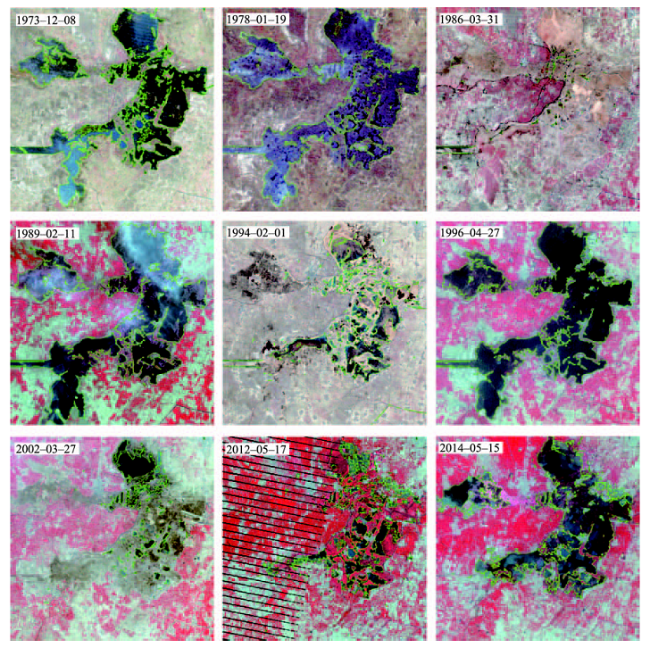
Fig. 2 Water extraction result during several important periods for the Baiyangdian region图2 白洋淀地区几个重要时期的水体面积提取结果 |
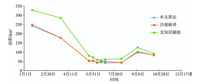
Fig. 3 Area change plot of different periods in 1978 using the proposed algorithm图3 本文算法在1978年不同时期影像的提取面积曲线图 |
Fig. 4 Area change plot of water in the Baiyangdian region in the past 43 years图4 白洋淀地区43年来水体面积变化曲线 |
The authors have declared that no competing interests exist.
| [1] |
[
|
| [2] |
[
|
| [3] |
[
|
| [4] |
[
|
| [5] |
|
| [6] |
[
|
| [7] |
|
| [8] |
|
| [9] |
[
|
| [10] |
|
| [11] |
[
|
| [12] |
[
|
| [13] |
[
|
| [14] |
[
|
| [15] |
[
|
| [16] |
|
| [17] |
[
|
| [18] |
[
|
| [19] |
[
|
| [20] |
[
|
| [21] |
[
|
| [22] |
|
| [23] |
[
|
| [24] |
[
|
| [25] |
[
|
| [26] |
|
/
| 〈 |
|
〉 |