
Journal of Geo-information Science >
The Rapid Assessment Method of Earthquake Disaster Based on High-Resolution Remote Sensing Target Feature Library
Received date: 2015-12-15
Request revised date: 2016-02-16
Online published: 2016-05-10
Copyright
High-resolution remote sensing image has become a major source of information for the rapid assessment of earthquake disaster, and it also brings new challenges to the study and application of seismic disaster information extraction methods that are based on the remote sensing. The existing methods of seismic disaster information extraction that are based on the remote sensing technology have some defects, such as the high dependence on the visual interpretation experience of researchers and the low accuracy of extraction results produced from the high-resolution images. This paper provides a rapid extraction method of the high-resolution remote sensing seismic disaster information with the integration of target feature library. Via building the high-resolution remote sensing disaster target feature library, this method is capable to provide services for the accumulation and application of disaster features based on the high-resolution images, thus to meet the purpose of reducing the dependence on the experience of researchers and improving the automation level and efficiency of disaster information extraction from remote sensing images. Regarding to the method framework description, this paper introduces several key technologies in the progress of earthquake disaster rapid assessment, which includes building the target feature library and conducting the method of sample matching and automatic classification. This paper takes the earthquake prone region of Ludian, Yunnan as an example. The study area is in the central area of Longtoushan town, and the earthquake disaster rapid assessment experiment is supported by the high-resolution remote sensing target feature library. Comparing our experimental results with the field survey results, it shows that the accuracy of the experimental results can meet the service requirements of the rapid assessment. It also shows that the rapid extraction of seismic disaster based on high-resolution remote sensing disaster target feature library can effectively reduce the labor workload and strongly improve the automation level of services. Generally, this method has a positive significance to the disaster emergency response.
DONG Wen , SHEN Zhanfeng , CHENG Ximeng . The Rapid Assessment Method of Earthquake Disaster Based on High-Resolution Remote Sensing Target Feature Library[J]. Journal of Geo-information Science, 2016 , 18(5) : 699 -707 . DOI: 10.3724/SP.J.1047.2016.00699
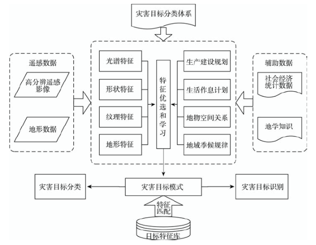
Fig. 1 The method for the rapid extraction of disaster information based on target feature library图1 基于目标特征库的灾害信息快速提取方法 |
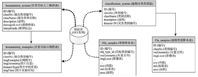
Fig. 2 Storage structure of high-resolution remote sensing disaster feature library图2 高分辨率遥感灾害特征库存储结构图 |
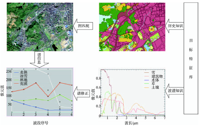
Fig. 3 Schematic diagram of the designed sample matching algorithm named “Graph Matching and Spectrum Correction”图3 “图匹配-谱修正”的样本匹配算法示意图 |
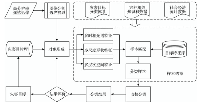
Fig. 4 Flowchart of the high-resolution image's automatic classification based on target feature library图4 目标特征库支持下的高分影像自动分类流程 |

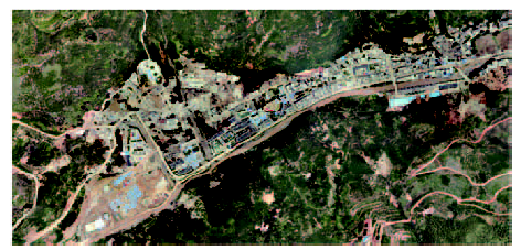
Fig. 5 Post-earthquake image of the experimental area in Longtoushan town of Ludian in Yunnan图5 云南鲁甸龙头山镇实验区地震灾后影像数据 |
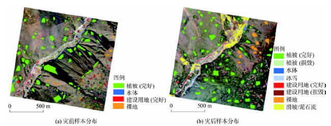
Fig. 6 Distribution of the matching results using the target feature library图6 目标特征库匹配结果分布 |
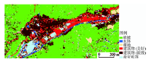
Fig. 7 Post-earthquake image automatic classification of the experimental area in Longtoushan town of Ludian in Yunnan图7 云南鲁甸龙头山镇实验区地震灾后影像自动分类结果 |
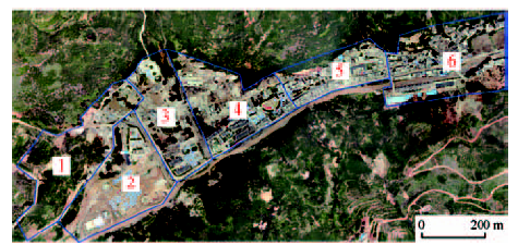
Fig. 8 Block diagram of the experimental area in Longtoushan town of Ludian in Yunnan图8 云南鲁甸龙头山镇实验区街区区划示意图 注:图中数字代表街区号 |
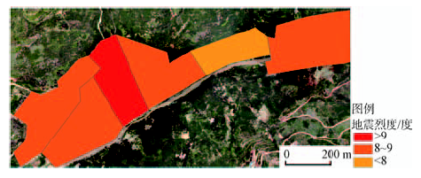
Fig. 9 Rapid assessment results of earthquake disaster for the experimental area in Longtoushan town of Ludian in Yunnan图9 云南鲁甸龙头山镇实验区地震快速评估结果 |
Tab. 1 Statistics of the rapid assessment for the experimental area表1 实验区快速评估结果统计表 |
| 倒损率/(%) | 参考烈度/度 | |
|---|---|---|
| 街区1 | 70.24 | 8.94 |
| 街区2 | 60.89 | 8.47 |
| 街区3 | 72.50 | 9.06 |
| 街区4 | 64.10 | 8.63 |
| 街区5 | 20.61 | 6.00 |
| 街区6 | 55.96 | 8.21 |
Tab. 2 Statistics of the damaged building area in Longtoushan town表2 龙头山镇住房倒损建筑面积统计表[18] |
| 完全倒塌/m2 | 严重损毁/m2 | 一般损毁/m2 | 倒损总数/万m2 | 建筑总面积/万m2 | |
|---|---|---|---|---|---|
| 砖木 | 98 966 | 75 787 | 82 241 | ||
| 砖混 | 79 105 | 150 356 | 205 916 | ||
| 钢混 | 0 | 27 501 | 33 469 | ||
| 其他 | 202 348 | 195 336 | 268 263 | ||
| 比例/(%) | 23.09 | 27.25 | 35.80 | ||
| 合计 | 141.93 | 164.77 | |||
The authors have declared that no competing interests exist.
| [1] |
民政部.民政部国家减灾办发布2013年全国自然灾害基本情况[EB/OL].,2014-01-04.
[Ministry of Civil Affairs. National Disaster Reduction Office of Ministry of Civil Affairs has published the 2013 national natural disaster general information[EB/OL]. , 2014-01-04. ]
|
| [2] |
[
|
| [3] |
[
|
| [4] |
|
| [5] |
|
| [6] |
[
|
| [7] |
[
|
| [8] |
|
| [9] |
|
| [10] |
|
| [11] |
|
| [12] |
|
| [13] |
[
|
| [14] |
|
| [15] |
|
| [16] |
|
| [17] |
中国地震局办公室.中国地震局发布云南鲁甸6.5级地震烈度图[EB/OL], , 2014-08-07.
[China Earthquake Administration Office. China Earthquake Administration has published the earthquake intensity map of Ludian, Yunnan 6.5 earthquake[EB/OL]. , 2014-08-07. ]
|
| [18] |
民政部国家减灾中心.云南鲁甸6.5级地震灾害遥感监测评估技术报告[R].北京:2014-08-29.
[ National Disaster Reduction Commission, Ministry of Civil Affairs. Remote sensing monitoring evaluation technical report of Ludian, Yunnan, 6.5 earthquake[R].Beijing:2014-08-29. ]
|
/
| 〈 |
|
〉 |