Orginal Article

Spatial Pattern Analysis on the Supply and Demand of Registered Parking Lots in Beijing

  • HU Ruishan , 1 ,
  • YANG Zhenshan , 1, 2, * ,
  • ZHANG Wanying 3
Expand
  • 1. Institute of Geographic Sciences and Natural Resources Research at Chinese Academy of Sciences, Beijing 100101, China
  • 2. Key Lab of Regional Sustainable Development and Modelling at Chinese Academy of Sciences, Beijing 100101, China
  • 3. Renmin University, Beijing 100872, China
*Corresponding author: YANG Zhenshan, E-mail:

Received date: 2015-06-25

  Request revised date: 2015-10-22

  Online published: 2016-06-10

Copyright

《地球信息科学学报》编辑部 所有

Abstract

With the fast growing of vehicle population, parking is turning into an important element of urban management. The tension between the supply and demand of parking has caused a series of serious problems, such as the illegal parking, the increase of cruising time, the safety issues of cars and drivers, and the air pollution. From the spatial perspective, this paper examines the supply-demand relationship of the registered parking plots in Beijing in 2014. Specifically, the two-step floating catchment area method was used to analyze the situation and pressure of parking by comparing the supply of parking plots and the demand at a street level. The study shows that most of the urban centers face the big pressure on the parking demand, and 41.5% of the streets, 72.3% of the area and about 41.7% of the population in Beijing urban area have their accessibility to the registered parking spots to be less than 5 for every hundred people. The accessibility to the registered parking area is higher in the urban center than in the periphery area, and the lowest values are found to be located between the fourth-fifth south ring road, along the fifth ring road, along the third northwest ring road and the urban central axis, excluding the Donghua Gate Street. Higher accessibility is found to be in the financial street and the central business district, while Zhongguancun area does not have a high accessibility to registered parking areas. Future management planning should emphasize and increase the number of registered parking lots, especially in the key urban functional areas and in the old residential communities, with the consideration of adjusting parking fee standard to influence people’s transportation and parking behavior.

Cite this article

HU Ruishan , YANG Zhenshan , ZHANG Wanying . Spatial Pattern Analysis on the Supply and Demand of Registered Parking Lots in Beijing[J]. Journal of Geo-information Science, 2016 , 18(6) : 779 -786 . DOI: 10.3724/SP.J.1047.2016.00779

1 引言

随着社会经济的快速发展和人民生活水平的不断提高,汽车开始成为一项重要和常见的交通工具。据统计,中国城市民用汽车从1990年的551万辆增加到2013年的12 670万辆,而同期城市人口从3.1亿增加到7.3亿,民用汽车的年均复合增长速度为14.6%,远高于城市人口增加速度(3.6%)。2009年中国超过美国成为世界第一大汽车产销地[1],停车已成为中国城市管理的重要内容。停车是每一次交通出行的衔接,停车困难将会对出行选择和行为造成影响[2-3]。另外,不合理、不规范的停车,不仅对公共造成了路权的剥夺,也会存在安全隐患和影响交通效率[4]。按照国际上较为合理的城市车辆与车位比例(1:1.3),大城市普遍存在停车位供给不足的问题[5]
城市停车问题影响到城市的经济和生活,既影响城市正常功能的发挥,也给居民驾车出行造成障碍[2,6],引起了国内外学者的广泛关注[7-8]。在停车需求预测方面,提出了包括利用数学和系统动力学模型对停车需求进行预测的方法[9],考虑路内停车的元胞自动机交通流模型[10],基于相空间重构及Elman网络的停车位预测方法[11],以及现状和预测相结合的方法和模型等[12]。有的学者关注停车行为对停车需求产生的影响,如对地铁停车换乘行为与需求预测[13-14],分析出行目的、公车、私车类型、家庭与个人等出行信息对停车需求的影响[15-18],或者分析不同地区的停车需求与特征差异,如公园[19]。综合来看,区域土地利用状况、人口、机动车拥有水平以及社会经济状况、交通发展政策对停车需求预测具有重要的影响,合理的停车需求预测对停车场供给具有重要参考意义[20]
停车不仅包含停车位置的供需问题,还涉及城市管理与规划问题[21-23]。在管理问题上,许多学者在停车收费方面开展了大量的论证与研究[24-26]。例如,吕国林和孙正安在对交通拥堵状况和停车收费状况进行分析的基础上提出“分区、分类、分时”差别化的停车收费调整的总体思路[27],通过经济杠杆来调节人的出行方式和停车行为。也有学者希望在管理和规划中要重视交通与用地开发的反馈机制、改善商业密集区停车、强化交通影响评价制度和推行停车配建建设补偿制度[28]
空间相对位置对于停车管理具有重要意义[29]。停车难不仅体现在供给总量上的不足,而且更加突出地反映在城市的某个具体地区。这是因为停车与车辆拥有者和使用者所在的居住地、就业地、出行目的具有密切的关系。备案停车场作为政府的主导行为,就需要考虑停车供需的空间关系。在城市社会经济空间高度集聚化的过程中[30],停车难的问题在空间上被极化了,表现为供需的空间不平衡性。因此,停车管理需要认真考虑车位供给与城市主要职能的空间位置关系,如居住、就业、医院、学校、大型商场和主要娱乐场所等。刘婧等通过抽样调查的方法对北京市的停车行为进行了调查,结果表明,供给不足仍然是停车遇到的最主要的问题[31]。李志瑶等利用停车信息记录研究了北京市停车行为特征,总结大中城市停车信息的主要特点和停车供求不平衡的症结所在,并提出增加供给、调整收费结构、减少路内停车场的供给和增加交通枢纽停车换乘设施供给建议来改善停车状况[18]。宗刚等认为北京市停车场集中度偏低和停车场建设回收周期长影响了停车场的供给和社会资本的积极参与,未来发展应从备案制度向特许经营制度过渡[32]。目前,还鲜有从微观尺度对空间供需关系对停车问题或规范化管理进行分析研究。而这一研究恰恰可以揭示微观空间单元,如街道,停车水平与矛盾,为缩小现实与管理期望的差距,提高政府精细化管理水平提供技术途径。
为充分了解停车场供需空间分布特征,本文以北京市为研究区,以居住人口停车需求为参照对象,以街道为分析单元,利用2014年12月底备案停车位数据,分析北京市备案停车场的空间分布特征和规律,以期为北京市停车场科学管理,缓解交通困境提供决策参考。

2 北京市汽车增长与停车场供给现状

随着社会经济的发展,北京市民用汽车数量显著性提高,从1980年的8万辆,增加到2010年的453万辆。近年来随着限购政策的实行,虽然年均汽车增长率控制在4%~5%左右,但2013年全市的民用汽车也达到了519万辆。根据2014年北京市交通委提供的数据,备案停车场提供的停车位只有171.6万个,停车位的供给存在巨大缺口。汽车的高速增长对城市发展带来了压力。
空间上,城市核心区和拓展区压力尤为显著。按汽车人均拥有量计算,2012年全市每百人汽车拥有数量为24辆,首都功能核心区为37辆,高出全市平均数量的50%,其中东城区和西城区每百人汽车拥有量最高,分别为42辆和34辆。城市功能拓展区的人均拥有量与全市平均水平大体相当,城市发展新区和生态涵养区略少于全市平均水平(表1)。
Tab. 1 The number of civilian cars in Beijing in 2012

表1 2012年北京市民用汽车拥有量

民用汽车
拥有量
/辆
占全市
总量比
重/(%)
每百人拥有民用汽车数量 所需停车面积与区域建成区面积的比值/(%)
全市 4 957 409 100 24 2.35
首都功能核心区 822 176 16.58 37 14.29
城市功能拓展区 2 468 381 49.79 24 4.99
城市发展新区 1 299 610 26.22 20 1.25
生态涵养发展区 367 242 7.41 19 0.71
按照一般车位停放面积16 m2来计算,高昂的土地价格和建设成本使得车辆停放需求对停车场供给构成了巨大压力。2012年,全市停车所需面积与建成区面积的比值为2.35%,其中东城和西城最高,分别达到14.6%和13.9%。停车难的问题在未来城市发展中越发凸显,停车场供给不足不仅体现在数量上,空间分布的差异可能导致供需矛盾更加激烈。

3 研究数据与方法

3.1 数据来源及预处理

由于主城区和偏远郊县空间大小的差异,本文主要分析主城区,即首都功能核心区和城市功能拓展区。以居住人口为参照,以街道或者乡镇为单元进行空间化处理(图1),其中居住人口数据采用北京市第六次人口普查数据。备案停车场数据由北京市交通委提供,数据显示截止到2014年12月北京市备案停车场数为6320个,停车位数为171.6万个。首先对停车场地址进行了地理编码和空间校对,为计算距离方便,把停车场近似提取为点,空间化后结果如图2所示。
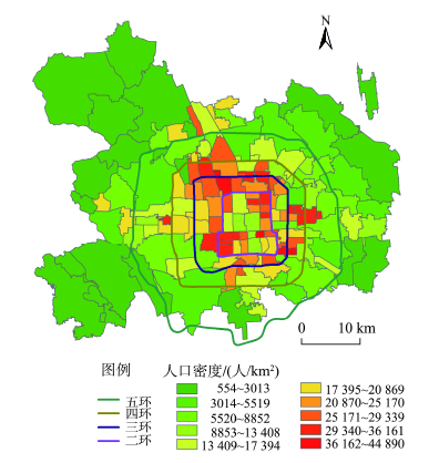
Fig. 1 The population density of Beijing areas in 2010

图1 北京市中心城区2010年人口密度图

3.2 研究方法

首先,建立北京市城乡道路拓扑网络,建立居住人口和备案停车场的对应关系。通过O-D矩阵求取306个乡镇、街道和地区到6320个停车场之间的最短路网距离和网络时间。经过网络分析,在街道和停车场之间共产生了193万多条记录,记录了两两之间最短通行时间。交通数据由国家测绘局提供,路网拓扑在ArcGIS 10.2下完成,具体道路等级和速度设置参考2004年《公路技术标准》,并结合北京市道路实际平均速度进行设置。
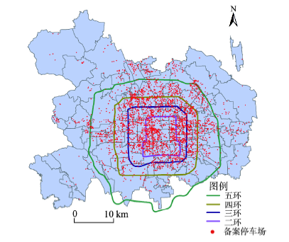
Fig. 2 The spatial distribution of registered parking lots in Beijing areas in 2014

图2 2014年北京市中心城区备案停车场空间分布图

其次,利用两步移动搜索法来对备案停车场进行空间分析。两步移动搜索法实质上是引力模型的一个特例,两步移动搜索法的优点是直观和计算简单。引力模型为汉森模型[33]转换得到,其表达方式如式(1)所示。
A i H = j = 1 n S j d ij - β (1)
式中: A i H 是街道 i 的停车的可达性; S j 是停车场j的供给规模; d ij 是供需两地之间的距离或通行时间;β是交通摩擦系数; n 是停车位的总数。式(1)没有考虑需求者在分享有限供给时的竞争。威布尔[34]对这一模型进行了改进,改进后的模型表达方式如(2)、(3)所示。
A i G = j = 1 n S j d ij - β V j (2)
其中,
V j = k = 1 m D k d kj - β (3)
式中: A i G 是基于引力模型的可达性指数;nm分别供应和需求点数目; S j 是供应点j 的服务能力,本文以停车位数来表示; d ij 是需求点 i 和供应点j之间的时间或距离; V j 是供应点影响范围内需求点 i的总和( d ij d 0 , d 0 是供给点的影响阈值,用时间或距离表示),用潜在需求点的人口数表达; D k 为搜索区内的街道、乡镇和地区数; d kj 是需求点k和供给点j之间的距离或者时间;β是交通摩擦系数。 A i G 的值越大,表示空间可达性越好。
穆兰和Radke[35]对早期的引力模型进行了改进,并由罗卫和王法辉等[36]进一步改进为两步移动搜索法。鉴于引力模型对偏远地区的可达性测度有夸大的倾向[37-38],本文采用基于路网时间的两步移动搜索法来计算街道、乡镇和地区与停车场之间的可达性,分析北京市停车场和停车位供给显著不足地区。两步法的第(1)步确定供给点(本文指停车场)服务阈值( d 0 )内的供需比(本文是车位和人口的比值,计量单位为每百人拥有停车位数);第(2)步计算消费者可达性,即计算本文采用的计算街道或者乡镇的停车场数,并把这些停车场的供需比加总,即得到各个街道或者乡镇的停车场可达性。本文分别取街道、乡镇和地区到停车场通行时间4 min为服务阈值( d 0 ),通行距离约为2~3 km,这一距离是居民停车后步行返回居住点近似可以忍受的距离,尺度上和中心城区街道尺度相当,比大的街道和乡镇尺度要小,假设只有处于阈值范围内的供给和需求者才能发生交易。
Tab. 2 Statistics of the accessibility for the registered parking lots in each street within the study areas

表2 各研究城区按街道统计的备案停车场可达性统计

0AiF<5 5AiF<10 10AiF<15 15AiF<24 AiF24
区县 街道数/个 面积/km2 人口/人 街道/个 面积/km2 人口/人 街道数/个 面积/km2 人口/人 街道数/个 面积/km2 人口/人 街道数/个 面积/km2 人口/人
东城区 6 14.1 280 726 5 13 340 765 2 3 80 433 2 4.62 109 945 2 7.40 107 384
西城区 2 8.83 226 662 4 13.16 394 566 5 11 301 234 4 17.68 310 295
朝阳区 16 302.08 1 259 831 12 76.97 1 097 576 3 15 196 412 4 13.75 166 397
海淀区 13 334 1 454 343 8 47.46 1 048 637 4 34.30 368 825 4 14.713 380 423
丰台区 11 265.29 918 947 4 34.50 521 459 2 5.99 166 884 4 34.3 368 825 4 14.71 380 423
石景山区 6 72 479 627 3 12.65 113 607
合计 54 996.3 4 620 136 36 197.74 3 516 610 16 69.29 1 113 788 18 85.063 1 335 885 6 22.11 487 807
占城六区同类指标比例/(%) 41.54 72.30 41.72 27.69 14.35 31.75 12.31 5.03 10.06 13.85 6.17 12.06 4.62 1.60 4.40
第(1)步,对于每个停车场j,搜索所有离j距离阈值( d 0 )范围内的街道、乡镇和地区(k),计算出每个停车场的供需比 R j (式(4))。
R j = S j D k (4)
式中: d kj 为街道、乡镇和地区中心k和停车场j之间的距离; S j j点的停车位数,即总供给。
第(2)步,对每个乡镇、街道和地区i,搜索所有在服务阈值( d 0 )范围内的停车场的车位数,将所有停车场的供需比 R j 加在一起即得到街道、乡镇和地区i点的备案停车场的可达性 A i F (式(5))。
A i F = R j = S j D k (5)
式中: d ij 是街道、乡镇和地区i和停车场j之间的距离; R j 是以街道、乡镇和地区为中心的i搜索区( d ij d 0 )内的停车场j的车位的供需比。 A i F 越大,则可达性越好。

4 备案停车场空间潜在可达性分布

分析结果显示,受空间分布影响,相对于居住人口的备案停车场分布比值较高的单元主要分布在国贸、金融街和中关村等地区。二环内、北三环和北四环之间以及东二环和东三环之间,五环以外有少部分不连续高值区分布。
从研究区内的各个区县来看,目前分析区内只有东城区2个街道(东直门街道和东华门街道办事处)和朝阳区4个街道(三里屯、呼家楼、麦子店和团结湖街道办事处)备案停车场数量超过了24个,占到了研究区内街道总数的4.6%,覆盖了4.4%的人口和1.6%的面积。这几个区域备案停车场可达性基本上与全市范围内每百人汽车拥有量相当,供给刚刚能达到平衡(图3)。但是考虑到这些地区商贸发达、经济活动频繁,动态人口停车供给仍然紧张。如果按照首都功能核心区每百人37辆计算,尚没有街道能满足停车需求。与此形成剧烈反差的是,研究区内仍然有41.5%的街道,72.3%的面积内每百人备案停车位少于5,覆盖人口占研究区内人口的41.7%。这说明北京市主城区备案停车场存在严重供给不足问题。
按城市功能分区特征来看,核心区(东城区和西城区)和功能拓展区(海淀区、丰台区、朝阳区和石景山区)四环以内部分要显著高于功能拓展区的外围部分,老旧小区占比较高的街道由于停车位较少,居住停车可达性也较低。传统的三大功能中心(金融街、CBD和中关村),金融街、CBD居住停车可达性要比中关村地区好。
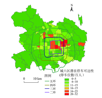
Fig. 3 Spatial distribution of the accessibility for the parking lots in Beijing downtown areas in 2014

图3 2014年北京市中心城区停车场可达性空间分布图

以停车位与车辆拥有量进行比较分析,进一步揭示当前停车供需对比状况。理想状态下,应在街道尺度上进行对比,但受数据限制无法得到街道级的汽车拥有量,因此用各个区的汽车拥有量平均值来代替,获取一个近似的结果。按照国际惯例,一般认为停车位与车辆拥有量的比值应该在1.3:1比较合理[5],有的国家(如日本)在1:1.05左右。通过假设规范化管理后,停车完全由备案场来提供,来分析现实与规范化管理的差距(图4)。当比值小于1.3时,供给可能存在不足,值越小,差距越严重。目前分析表明还没有任何一个街道比值大于1.3,供需比值较高的地区位于北二环以里北部地带及其向三环和四环的延伸处;另外,北四环周边地区、亦庄地区及其外围一些地区,(如海淀街道办、花园路街道办和十八里店地区)备案停车场供给相对较多。整体上,越向主城区外围,规范化备案停车场越不足。
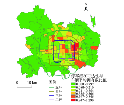
Fig. 4 The ratio of the potential spatial accessibility of parking lots to the demands in Beijing downtown areas in 2014

图4 2014年北京市中心城区中心城区停车场潜在可达性与需求比

分析结果显示,主城区129个街道和乡镇分析单元中,只有三里屯街道潜在的规范停车可达性和实际每百人拥有车辆比值大于1.3,从居住人口停车需求的角度来说实现供需基本平衡。有15个街道在2~3 km通行距离内没有可供选择的备案停车场,其中有14个分布在五环外,其余113个街道和乡镇停车位可达性与人均汽车拥有量的比都小于1.3,比值在0.5以下的有110个街道,占中心城区街道数85.27%。停车位严重缺乏区域主要为南四环与南五环之间,五环附近及五环外,西北三环附近,二环内备案停车位不足区域主要位于城市中轴线上除了东华门街道外的街道。和居住停车可达性类似,核心区和城市功能拓展区四环内部分供需比状况要好于外围地区。CBD和金融街供需比整体较好且高于周边地区,中关村地区供需相对居住可达性,也有所提升,要好于周边地区。二环和三环之间老旧小区占比较高的街道居住停车供需比要低于周边地区,这些小区多是20世纪80年代以前建成,缺乏备案停车场。

5 结论

本文基于居住人口和停车场地理编码数据,采用两步移动搜索法分析了北京市主城区停车位供需对比的空间分布差异。从数量上看,按照供需平衡来评价,北京市主城区备案停车场及停车位供给存在严重不足,难以满足居民停车需求。备案停车场停车位空间可达性差异显著,停车位严重不足地区主要分布在南四环与南五环之间,五环附近及五环外,西北三环附近,以及二环的城市中轴线上除东华门街道外的地区。核心区和城市功能拓展区的四环环内区域停车可达性要好于外围地区。中心城区虽然从数据分析结果上并没有外围地区严重,但是本文分析过程中并没有考虑工作、购物、旅游和就医等机动性人口带来的竞争,类似CBD和金融街这些机动人口高度汇集地区的停车可达性可能会被高估;同时,也无法确定一些小区内没有备案的停车位所增加的供给,这方面可能会使这部分街道停车位可达性被低估。虽然2种因素的消长可能会带来停车位可达性的浮动,但本文的分析结果仍不失其参考价值。在分析尺度上,小区或街区是更为理想的分析单元,但无法获取准确动态的人口和车辆数据。城市核心区和四环内的城市拓展区的乡镇或街道单元相对较小,分析结果的参考价值更高,也是大家更为关注的地区,四环外的城市拓展区分析单元则相对较大,分析结果估值精度可能会偏低。
本文仅分析了居住人口潜在的停车位需求,实际机动停车需求如不同类型停车场白天和夜晚停车需求差异的数据难以获取,这里并没有涉及。对于停车场管理者而言,除了要关注居住停车场的供需差异外,还应考虑如就业、购物、就医和休闲等机动性停车需求,实际应用中还应增加这部分停车需求的研究。在停车场管理方面,除了要增加严重稀缺地区停车位供给外还应增加停车诱导系统的运用,提高停车场的使用效率。
受限于城市空间的稀缺性,主要靠增加供给来满足北京市停车需求也并不现实,同时在目前的价格水平下增加中心城区停车位的供给可能会进一步刺激对私人小汽车的使用,进而增加交通拥堵,未来应该运用价格手段合理调节人们的出行方式,减少依托小汽车的出行行为,增加公共交通出行。对于部分老旧小区,应通过对停车场的技术改造,增加这些区域存量停车需求的供给,以减少违章停车行为的发生。

The authors have declared that no competing interests exist.

[1]
《道路交通管理》编辑部.汽车时代的城市停车问题[J].道路交通管理,2010(3):18-19.

[ Editorial department of the journal of road traffic management. The problem of urban park at automobile time[J]. The Journal of Road Traffic Management, 2010,3:18-19. ]

[2]
Moutou C J.Car parking matters: adapting to changing customer mobility in neighborhood town centers of an inner city area of Sydney[J]. Journal of Urban History, 2013,39(4):690-708.

[3]
Zafari F, Mahmud S A, Khan G M, et al.A survey of intelligent car parking system[J]. Journal of Applied Research & Technology, 2013,11(10):714-726.

[4]
Al-Fouzan S A. Using car parking requirements to promote sustainable transport development in the Kingdom of Saudi Arabia[J]. Cities, 2012,29(3):201-211.The aims of this paper are to review the current practices of car parking standards in the UK, the USA, and the Kingdom of Saudi Arabia (KSA); to draw the main lessons learned from experiences of the UK and the USA; and to suggest suitable improvements in the standards of car parking requirements in the KSA. The paper follows a comparative approach in reviewing car parking standard requirements according to different types of land use in the UK, the USA, and the KSA. The article illustrates that transportation planners in the UK and the USA use parking policies, especially the application of car parking standards, along with other planning and transport measures to promote sustainable transport choices, to reduce reliance on cars, and to reduce traffic and air pollution. Local authorities in the UK and the USA have moved from requiring minimum standards for car parking to maximum standards. The aim of maximum parking standards is to decrease the number of trips made by private cars whilst seeking to maintain and enhance the viability of economic centres and support sustainable development. In the KSA, authorities still adhere to minimum car parking standards. Moreover, the car parking requirements are not correlated with city zoning systems. The paper concludes with some thoughts on how to improve the current parking requirements in KSA cities.

DOI

[5]
章亚南,冯俊文.城市泊车管制政策目标评价[J].生产力研究,2005(11):146-147.

[ Zhang Y N, Feng J W.Evaluation on urban parking management policy[J]. The Produtivity Research, 2005,11:146-147. ]

[6]
Guo Z, McDonnell S. Curb parking pricing for local residents: an exploration in New York City based on willingness to pay[J]. Transport Policy, 2013,30:186-198.This paper investigates the feasibility of charging residents for on-street parking in dense urban neighborhoods as a way to clear parking supply and demand. The authors elicited residents' willingness to pay (WTP) for a hypothetical parking permit program in New York City using a payment card approach, and estimate the key determinants through a Double Hurdle model. A little more than half of respondents (52.5%) are willing to pay for an average $408 per year, even though the revenue is not specified to be returned back to the neighborhoods. Pricing becomes more acceptable in neighborhoods where the major parking problem is shortage and crowding caused mainly by local residents instead of parking intrusion by non-residents. The WTP value varies by resident car ownership and home parking types. The results suggest that curb parking pricing for local residents might be both economically and politically feasible in certain dense urban neighborhoods.

DOI

[7]
Wang J J, Liu Q.Understanding the parking supply mechanism in China: a case study of Shenzhen[J]. Journal of Transport Geography, 2014,40:77-88.

[8]
Payre W, Cestac J, Delhomme P.Intention to use a fully automated car: attitudes and a priori acceptability[J]. Transportation Research Part F Traffic Psychology & Behaviour, 2014,27:252-263.

[9]
秦焕美,关宏志,潘小松.基于随机连续平衡模型的停车换乘需求[J].吉林大学学报(工学版),2012,42(2):321-326.为了分析出行者的停车换乘需求分布特性,本文假设在轨道交通和城市主干道的单中心城市中,出行需求均匀分布,轨道交通上有连续分布的站点,基于效用理论构建了考虑出行者出行方式(小汽车、轨道交通、停车换乘)和换乘地点选择的分层非集计模型,利用随机连续平衡模型方法并结合算例,得出:停车换乘需求在一定距离范围内呈现高峰,停车换乘需求总量随着换乘时间的增加而减少;各换乘点均吸引了一些回程换乘需求,但需求强度较小,从城市周边吸引换乘需求量较大,需求强度随着与换乘点距离的增加而减少;当换乘停车场容量受限制时,停车换乘需求者会改变换乘点的选择。研究结果对停车换乘设施规划建设具有一定的参考价值。

[ Qin H M, Guan H Z, Pan X S.Park and ride demand based on stochastic continiuum equiliburium model[J]. Journal of Jilin University (Engineering and Technology Edition), 2012,42(2):321-326. ]

[10]
刘小明,王力.考虑路内停车的元胞自动机交通流模型[J].吉林大学学报(工学版),2012,42(2):327-333.为了研究路内停车对路段交通的影响,针对路内停车条件下车辆行为过程分别建立相应的元胞自动机行为规则,进而应用上述规则对不同参数设置下的交通流演化过程进行数值模拟,并分析和讨论了路内停车条件下交通相变特性。研究结果表明,在双向双车道有路内停车路段中,车辆换道至对向车道概率的增加导致路段交通流密度较低时也能发生阻塞;路段交通流密度增大使对向交通阻塞概率增加,而待停车概率增大导致路段交通流平均速度降低的同时未必使对向交通阻塞概率增加。

[ Liu X M, Wang L.Cellular automaton traffic flow model considering on street parking[J]. Journal of Jilin University (Engineering and Technology Edition), 2012,42(2):327-333. ]

[11]
陈群,晏克非,王仁涛,等.基于相空间重构及Elman网络的停车泊位数据预测[J].同济大学学报(自然科学版),2007,35(5):607-611.针对停车诱导系统(PGIS)中短时空余停车泊位时间序列数据预测问题,提出应用相空间重构 与Elman神经网络相结合的方法来进行预测.首先分析了相空间重构的技术原理,在此基础上导出时间序列预测模型,并以Elman神经网络训练模拟该模 型.介绍了相空间重构与Elman神经网络相结合的预测方法的具体实现过程与步骤,提出了短时空余停车泊位数据的预测效果评价指标.通过预测实例表明,该 方法用于停车诱导系统中短时空余停车泊位数据的预测具有较好的预测准确性和有效性.

DOI

[ Chen Q, Yan K F, Wang R, et al.Parking space information prediction based on phrase construction and Elman neural network[J]. Journal of Tongji University (Natural Science), 2007,35(5):607-611. ]

[12]
Wu D H.Parking demand forecasting method in old town based on current survey[J]. Journal of Transportation Systems Engineering and Information Technology, 2014,14(1):235-241.To overcome the limitations of traditional urban parking demand forecasting method,which predict the parking demand of the old town,the paper studys the parking demand forecasting method of the old town. On the base of contrasting the advantages and disadvantages among traditional parking demand forecasting methods,a new parking demand forecasting method is put forward to use the correlation between the motor vehicle growth rates and parking demand. The method has obvious advantages than traditional prediction method in predicting the reliability,costs of investigation and prediction parking distribution depth. Case study results show that the relative error of the recent forecast less than 5% compared with the method based on the number of cars,the investigation cost savings 30%-40% than the motor vehicle OD prediction method and traffic-parking demand forecasting method,and the forecast parking distribution can be obtained for each traffic survey within the district. The results also show that the method can be applied and promoted in the old town parking demand forecasting.

[13]
唐伟成,陈莹.南京地铁停车换乘行为选择研究[J].现代城市研究,2011(5):76-79.停车换乘(P&R)作为减少小汽车使用、缓解城市交通拥挤的重要措施之一.被许多发达国家所采用并取得了一定效果。本文以南京地铁停车换乘系统为例.通过对停车换乘行为影响因素分析,结合出行者RP和SP调查.建立了南京地铁停车换乘的行为选择模型.并对其结果进行了论述。本文为南京市进一步建设地铁停车换乘系统提供了一定参考。

DOI

[ Tang W C, Chen Y.Research on the mode choice of subway park & ride in Nanjing[J]. Modern Urban Research, 2011,5:76-79. ]

[14]
李媛,张秀媛.北京市地铁5号线天通苑地区停车换乘需求预测[J].城市交通,2010,8(5):57-64.针对北京市地铁5号线天通苑北 站P+R停车场规模与实际停车换乘需求不匹配的问题,研究确定其停车换乘需求的预测方法,并提出解决停车设施供给不足的方案。在分析天通苑地区P+R停车 场时间、车辆来源及设施供给情况的基础上,建立Logit随机均衡交通方式选择模型,得到该地区高峰小时停车换乘需求量为1476个泊位。同时,将预测结 果与天通苑北站P+R停车场实际可扩展停车规模进行比较,提出在瓶颈路段设置新的P+R停车场的方案,并建立了系统优化平衡模型,对该地区的停车换乘需求 进行分配。结果表明,新建P+R停车场规模分别为300,400,500和600个泊位的条件下,停车换乘需求基本按照两个停车场的规模比例分配停车数 量。

DOI

[ Li Y, Zhang X Y.Park & ride demand forecasting at Tiantongyuan area along Beijing subway line five[J]. Urban Transport of China, 2010,8(5):57-64. ]

[15]
Lusk A C, Wen X, Zhou L.Gender and used/preferred differences of bicycle routes, parking, intersection signals, and bicycle type: professional middle class preferences in Hangzhou, China[J]. Journal of Transport & Health, 2014,1(2):124-133.The objective of this study was to assess preference differences of females, bicyclists, bicyclists/non-bicyclists, and >3 days/week bicyclists about cycle tracks, surrounding environments, parking, signals, and bicycle type among middle class professionals in Hangzhou, a premier bicycling city in China. Surveys were distributed to 1200 middle school students that 1150 parents/adults completed (95.8% completion rate). Multiple linear regression was used to study associations between frequency of bicycling and age, gender, education, income, obesity, and car ownership. Cycle tracks were a maximum of 15 feet wide, enabling side-by-side bicycling, with continuous landscaped islands a maximum of 7 feet wide between the road and the cycle track with trees over 40 years old. Almost all knew how to bicycle, 77% of men and 72% of women owned a car, and, of these car owners, 43.8% bicycled each week. Only 47.1% of men and 55.1% of women did not bicycle. Bicycling was deemed enjoyable due to the beautiful surrounding environment (52.7% strongly agreed/agreed). Gender differences were statistically significant for preferring bicycle signals (63.7% men, 69.1% women) and cycle tracks (53.9% men, 60.2% women). Used/preferred differences were statistically significant for bicycle signals (33.8% used versus 71.4% preferred), parking sheds (39.8% used versus 62.7% preferred) and cycle tracks (34.4% used versus 58.6% preferred). Percentages for overweight were significantly different between owning a car (28.8%) and not owning a car (21.0%). Cities could test other city's innovations including parking sheds, bicycle signals, public bicycles, and wide-landscaped cycle tracks with trees between the cycle track and the road.

DOI

[16]
Ji Y, Guo W, Blythe P, et al.Understanding drivers' perspective on parking guidance information[J]. IET Intelligent Transport Systems, 2014,8(4):398-406.

[17]
Chidambaram B, Janssen M A, Rommel J, et al.Commuters’ mode choice as a coordination problem: a framed field experiment on traffic policy in Hyderabad, India[J]. Transportation Research Part A Policy & Practice, 2014,65:9-22.

[18]
李志瑶,宗芳,张炳辉.大中城市停车行为信息分析[J].情报科学,2011(12):1896-1901.

[ Li Z Y, Zong F, Zhang B H.Study on parking information behavior in large and medium-sized cities[J]. Information Science, 2011,12:1896-1901. ]

[19]
Clayton W, Ben-Elia E, Parkhurst G, et al.Where to park? a behavioural comparison of bus park and ride and city centre car park usage in Bath, UK[J]. Journal of Transport Geography, 2014,36(2):124-133.Integrating car parking facilities with public transport in Park and Ride (P&R) facilities has the potential to shorten car trips, contributing to more sustainable mobility. There is an ongoing debate about the actual effects of P&R on the transport system at the subregional level. A key issue is the relative attractiveness of city center car parks (CCCP), P&R and public transport. The paper presents the findings of a comparative empirical case-study based on a field survey of CCCP and P&R users conducted in the city of Bath, UK. Spatial and statistical analysis are applied. Radial distance to parking, availability of P&R sites in the direction of travel, gender, age, income and party-size are found to be important factors in a binary logistic regression model, explaining the revealed-preference of parking type. Stated analysis of foregone parking alternatives suggests more use of public transport and walking/cycling would likely occur without first-best parking alternatives. The policy implications and possible planning alternatives to P&R at the urban fringes for achieving greater sustainability goals are also discussed.

DOI

[20]
关宏志,王鑫,王雪.停车需求预测方法研究[J].北京工业大学学报,2006,32(7):600-604.为了能结合实际预测研究区域停 车需求,介绍了目前主要的停车需求预测方法及各自特点.在停车生成率模型基础上建立停车需求—供应预测模型,该模型考虑了价格因素、停车服务水平对停车需 求量的影响,将停车场周转率、利用率引入模型中,从而可直接得出实际应建停车位数量,同时,将停车需求分为白天和夜间分别进行预测,最后给出了计算示例.

DOI

[ Guan H Z, Wang X, Wang X.The research on forecasting method for parking demanding[J]. Journal of Beijing University of Technology, 2006,32(7):600-604. ]

[21]
Kaspi M, Raviv T, Tzur M.Parking reservation policies in one-way vehicle sharing systems[J]. Transportation Research Part B Methodological, 2014,62(2):35-50.In this study, we propose improving the performance of one-way vehicle sharing systems by incorporating parking reservation policies. In particular, we study a parking space reservation policy in which, upon rental, the users are required to state their destination and the system then reserves a parking space for them until they arrive at their destinations. We measure the performance of the vehicle sharing system by the total excess time users spend in the system. The excess time is defined as the difference between the actual journey time and the shortest possible travel time from the desired origin to the desired destination. A Markovian model of the system is formulated. Using this model, we prove that under realistic demand rates, this policy improves the performance of the system. This result is confirmed via a simulation study of a large real system, Tel-O-Fun, the bike-sharing system in Tel-Aviv. For all the tested demand scenarios, the parking reservation policy reduces the total excess time users spend in the system, with a relative reduction varying between 14% and 34%. Through the simulation we examine additional service-oriented performance measures and demonstrate that they all improve under the parking reservation policy.

DOI

[22]
Xiao X.A study of the motor vehicle parking management in China’s major cities[C]. Proceedings of 2nd International Conference on Logistics, Informatics and Service Science, 2013:1451-1456.

[23]
Rogers M, Rogers M, O'Riordan B. The sustainability of parking provision in Ireland[J]. Proceedings of the Institution of Civil Engineers-Transport, 2013,166(6):315-324.

[24]
Honarmand M, Zakariazadeh A, Jadid S.Optimal scheduling of electric vehicles in an intelligent parking lot considering vehicle-to-grid concept and battery condition[J]. Energy, 2014,65:572-579.The anticipation of a large penetration of EVs (electric vehicles) into the market brings up many technical issues. The power system may put at risk the security and reliability of operation due to uncontrolled EV charging and discharging. It is necessary to carry out intelligent scheduling for charging and discharging of EVs. In this paper, a smart management and scheduling model is proposed for large number of EVs parked in an urban parking lot. The proposed model considered practical constraints such as desired charging electricity price, remaining battery capacity, remaining charging time and age of the battery. The results show that the proposed parking lot energy management system satisfies both financial and technical goals. Moreover, EV owners could earn profit from discharging their vehicles as well as having desired SOC (state of charge) in the departure time.

DOI

[25]
Pierce G, Shoup D,石飞,等.停车收费合理定价——基于需求的旧金山停车定价模式评价[J].城市交通,2014(6):82-94.

[ Pierce G, Shoup D, Shi F, et al.Getting the prices right: an evaluation of pricing parking by demand in San Francisco[J]. Urban Transport of China, 2014,6:82-94. ]

[26]
郑士源. 信息不完全时公共停车场停车费和规模优化[J].交通运输工程学报,2010(5):81-89.为了对信息不完全情况下公共停车场的费率和规模进行规划,建立了规制经营和竞争经营2种管理模式下的停车费和规模优化模型。运用二维逆向选择和动态博弈方法得出了公共停车场最优停车费和规模的制定准则,分析了各因素对最优停车费和规模的影响。通过对2种模式下公共停车场的经营状况和社会福利的比较得知经营模式对停车费的影响不定;竞争经营模式下停车场的规模较规制经营模式下大94.21%;私人停车管理公司的利润较规制经营模式下高67.13%;停车服务需求较规制经营模式下大36.70%,社会福利较规制经营模式下高41.34%,可以看出竞争经营模式对公共停车场的经营管理和社会福利较为有利。

[ Zheng S Y.Parking fee and scale optimization of public parking lot with incomplete information[J]. Journal of Traffic and Transportation Engineering, 2010,5:81-89. ]

[27]
吕国林,孙正安.深圳市停车收费调整探索[J].城市交通,2014(1):12-17.为了有针对性地实施交通需求管理、调控小汽车通勤出行,对深圳市 停车收费调整方案及其立法保障进行研究和探索。首先对深圳市交通拥堵状况和停车收费状况进行分析,在此基础上提出“分区、分类、分时”差别化的停车收费调 整总体思路。重点针对小汽车通勤出行停车时间长、进出停车场时间集中两个特征,提出两种停车收费调整方案--交通方式转移和鼓励错峰出行,同时创新性地提 出征收行政性收费--路外停车场停车调节费,并将提高停车收费后停车场经营者新增的收益纳入市财政。最后,从制度层面探讨落实停车收费方案的相关立法保 障。

DOI

[ Lv G L, Sun Z A.Parking charge adjustment in Shenzhen[J]. Urban Transport of China, 2014,1:12-17. ]

[28]
晏勇. 黄石市老城区停车系统改善策略[J].城市交通,2014(1):28-33.

[ Yan Y.Parking system improvement strategies for old districts in Huangshi city[J]. Urban Transport of China, 2014,1:28-33. ]

[29]
Ibeas A, Dell’Olio L, Bordagaray M, et al. Modelling parking choices considering user heterogeneity[J]. Transportation Research Part A Policy & Practice, 2014,70:41-49.

[30]
杨振山,张慧,丁悦,等.城市绿色空间研究内容与展望[J].地理科学进展,2015,34(1):18-29.伴随社会经济快速发展,城市绿色空间对生态环境和宜居生活的作用逐渐受到关注。同时,随着城市建成区面积的不断扩大,城市绿色空间成为一种稀缺资源。不断减少的城市绿色空间,与城市人口的增加,以及其休闲健康功能需求的增长间形成了一种空间错位。如何合理规划绿色空间,发挥绿色空间的效用和功能,已成为城市地理学和城市规划实践中重要的研究内容。本文系统论述和梳理了城市绿色空间概念提出的背景和发展历程,并在此基础上综合分析不同学科对城市绿色空间的理解及研究成果,提出目前城市绿色空间的相关研究内容和进展;并对其研究趋势进行了分析,从城市规划建设、城市可持续发展、研究方法创新等方面提出了推动城市绿色空间相关研究的建议。

DOI

[ Yang Z S, Zhang H, Ding Y, et al.Progress and prospect on urban green space research[J]. Progress in Geography, 2015,34(1):18-29. ]

[31]
刘婧,贺玉龙,赵昕.大城市中心区停车行为调查[J].山西建筑,2015,41(9):1-3.以北京市西城区为研究目标,通过对公共停车场使用者进行车辆停放行为的调查分析,总结了西城区不同类型停车设施使用情况及存在的问题,并明确了停车者的停车决策特征,调查结果表明,停车费用可以作为调节供需的一种方式,同时西城区停车场存在监管力度不够的问题.

[ Liu J, He Y L, Zhao X.Parking behavior survey of big city center[J]. Shanxi Architecture, 2015,41(9):1-3. ]

[32]
宗刚,陈明.北京市出行停车市场集中度研究[J].价格理论与实践,2014(9):42-44.

[ Zong G, Chen M.The research on the parking market concentration ratio[J]. Price: Theory & Practice, 2014,9:42-44. ]

[33]
Hansen W G.How accessibility shapes land use[J]. Journal of the American Institute of Planners, 1959,25(2):73-76.An empirical examination of the residential development patterns illustrates that accessibility and the availability of vacant developable land can be used as the basis of a residential land use model. The author presents an operational definition and suggests a method for determining accessibility patterns within metropolitan areas. This is a process of distributing forecasted metropolitan population to small areas within the metropolitan region. Although the model presented is not yet sufficiently well refined for estimating purposes, the concept and the approach may be potentially useful tools for metropolitan planning purposes.

DOI

[34]
Weibull J W.An axiomatic approach to the measurement of accessibility[J]. Regional Science and Urban Economics, 1976,6(4):357-379.

[35]
Radke J, Mu L.Spatial decompositions, modeling and mapping service regions to predict access to social programs[J]. Geographic Information Sciences, 2000,6(2):105-112.ABSTRACT Although social programs intend to provide equal access for all, in the final evaluation, fairness of the distribution of services is usually dictated by location. Measuring and predicting access to social services can help these programs adjust and better accommodate under-served regions. A method is proposed which delineates the service area of providers delivering social services and produces a probability metric that maps the equity of the program of services for each household. We begin with a computationally trivial method for delineating service areas, map the probability of households being served, and propose an adjustment process, an allocation, to level access to services. We argue such methods can serve to better locate service providers and insure equity when implementing social programs.

DOI

[36]
Wang F, Wei L.Assessing spatial and nonspatial factors for healthcare access: towards an integrated approach to defining health professional shortage areas[J]. Health & Place, 2005,11(2):131-146.Abstract This research considers both spatial and nonspatial factors in examining accessibility to primary healthcare in Illinois. Spatial access emphasizes the importance of geographic barrier between consumer and provider, and nonspatial factors include nongeographic barriers or facilitators such as age, sex, ethnicity, income, social class, education and language ability. The population and socioeconomic data are from the 2000 Census, and the primary care physician data for the same year are provided by the American Medical Association. First, a two-step floating catchment area method implemented in Geographic Information Systems is used to measure spatial accessibility based on travel time. Secondly, the factor analysis method is used to group various sociodemographic variables into three factors: (1) socioeconomic disadvantages, (2) sociocultural barriers and (3) high healthcare needs. Finally, spatial and nonspatial factors are integrated to identify areas with poor access to primary healthcare. The research is intended to develop an integrated approach for defining Health Professional Shortage Areas (HPSA) that may help the US Department of Health and Human Services and state health departments improve HPSA designation.

DOI PMID

[37]
Hu R, Dong S, Zhao Y, et al.Assessing potential spatial accessibility of health services in rural China: a case study of Donghai county[J]. International Journal for Equity in Health, 2013,35(20):414-414.Introduction: There is a great health services disparity between urban and rural areas in China. The percentage of people who are unable to access health services due to long travel times increases. This paper takes Donghai County as the study unit to analyse areas with physician shortages and characteristics of the potential spatial accessibility of health services. We analyse how the unequal health services resources distribution and the New Cooperative Medical Scheme affect the potential spatial accessibility of health services in Donghai County. We also give some advice on how to alleviate the unequal spatial accessibility of health services in areas that are more remote and isolated. Methods: The shortest traffic times of from hospitals to villages are calculated with an O-D matrix of GIS extension model. This paper applies an enhanced two-step floating catchment area (E2SFCA) method to study the spatial accessibility of health services and to determine areas with physician shortages in Donghai County. The sensitivity of the E2SFCA for assessing variation in the spatial accessibility of health services is checked using different impedance coefficient values(a). Geostatistical Analyst model and spatial analyst method is used to analyse the spatial pattern and the edge effect of potential spatial accessibility of health services. Results: The results show that 69% of villages have access to lower potential spatial accessibility of health services than the average for Donghai County, and 79% of the village scores are lower than the average for Jiangsu Province. The potential spatial accessibility of health services diminishes greatly from the centre of the county to outlying areas. Using a smaller impedance coefficient leads to greater disparity among the villages. The spatial accessibility of health services is greater along highway in the county. Conclusions: Most of villages are in underserved health services areas. An unequal distribution of health service resources and the reimbursement policies of the New Cooperative Medical Scheme have led to an edge effect regarding spatial accessibility of health services in Donghai County, whereby people living on the edge of the county have less access to health services. Comprehensive measures should be considered to alleviate the unequal spatial accessibility of health services in areas that are more remote and isolated.

DOI PMID

[38]
Ngui A N, Vanasse A.Assessing spatial accessibility to mental health facilities in an urban environment[J]. Spatial and Spatio-temporal Epidemiology, 2012,3(3):195-203.Canadian provincial health systems are obligated to ensure access to health services for all citizens, based primarily on the principles of "universality" and "accessibility" which is enshrined in the Canada Health Act. Nevertheless, less than 40% of Canadian with mental health problems uses mental health services. Efforts to understand underutilization of mental health services have focused on individual and neighborhood characteristics. The aim of this study was to examine whether we could identify areas with mental health facilities shortage in the southwest of Montreal which may possibly explain disparities in access to mental health facilities. We applied the two-step floating catchment area method for our analyses. The results of our analysis show that mental health services are not equally distributed in the southwest of Montreal and in consequence, accessibility scores vary greatly from one DA to another.

DOI PMID

Outlines

/