
Journal of Geo-information Science >
Assessment Method and Application of Human Disturbance by Remote Sensing in the Biodiversity Conservation Priority Area
Received date: 2015-10-21
Request revised date: 2015-12-10
Online published: 2016-08-10
Copyright
In China, the biodiversity conservation priority area is an ecological protection system that promotes and enhances the ecosystem and biodiversity. Methods, which are based on the remote sensing data with a high temporal/spatial resolution and wide coverage and are designed for the supervision of human disturbance in the biodiversity conservation priority area, are currently expected to be established. The quantification and specialization of human activity intensity are the key issues for a supervision system to the environmental protection department on biodiversity conservation. Human disturbance index was proposed to achieve the fast dynamic monitoring of biodiversity conservation priority area. Through establishing the new index system and assessment method, and extracting and calculating the spatial distribution data by raster calculation function of geographical information system, the degree of human disturbance and dynamic change is assessed by the proposed index system using the GIS method. Firstly, according to the necessity of supervising the biodiversity conservation priority area, the classification system for human disturbance was established to describe its type and spatial pattern. Secondly, the human disturbance index system, which was derived from the classification data, was established to achieve a deeper level of assessment on human disturbance. Then, in order to determine the level of human disturbance, the model and method for disturbance assessment of biodiversity conservation priority area was established. The human disturbance index (HSI) was calculated based on the main monitoring index. The five-level disturbance assessment was used to differentiate the disturbance degree. Finally, the biodiversity conservation priority area in western Guangxi and southern Guizhou was taken as a case study to validate the proposed method. The results revealed the potential of this method to be applied to various biodiversity conservation priority areas. This method and technique process can provide a technical support to biodiversity conservation.
LIU Huiming , LIU Xiaoman , Li Jing , CAI Mingyong , WANG Qiao , PEI Liang , SHEN Wenming . Assessment Method and Application of Human Disturbance by Remote Sensing in the Biodiversity Conservation Priority Area[J]. Journal of Geo-information Science, 2016 , 18(8) : 1103 -1109 . DOI: 10.3724/SP.J.1047.2016.01103
Tab.1 Human disturbance remote sensing classification system表1 人类干扰分类体系及编码[13] |
| 目标层 | 指标层 | 代码 | 参数层 |
|---|---|---|---|
| 农业发展 | 耕地 | H1 | 耕地面积 |
| 基础设施建设 | 水库建设 | H2 | 水库面积 |
| 城镇用地 | H3 | 城镇用地面积 | |
| 居民点 | H4 | 居民点面积 | |
| 交通用地 | H5 | 交通用地面积 | |
| 工业用地 | H6 | 工业用地面积 | |
| 人工绿地 | H7 | 人工绿地面积 | |
| 资源开发 | 工矿用地 | H8 | 工矿用地面积 |
Tab.2 Conversion index of the construction land equivalent for different types of human disturbance表2 不同人类干扰类型的建设用地当量折算系数[24] |
| 目标层 | 指标层 | 代码 | 参数层 | CI |
|---|---|---|---|---|
| 农业发展 | 耕地 | H1 | 耕地面积 | 0.2 |
| 基础设施建设 | 水库建设 | H2 | 水库面积 | 1 |
| 城镇用地 | H3 | 城镇用地面积 | 1 | |
| 居民点 | H4 | 居民点面积 | 1 | |
| 交通用地 | H5 | 交通用地面积 | 1 | |
| 工业用地 | H6 | 工业用地面积 | 1 | |
| 人工绿地 | H7 | 人工绿地面积 | 0.133 | |
| 资源开发 | 工矿用地 | H8 | 工矿用地面积 | 1 |
Tab.3 Grading standards of human disturbance for biodiversity conservation priority area表3 优先区人类干扰指数分级标准 |
| 分级 | 参数层 | 人类活动程度 |
|---|---|---|
| 微度干扰 | <0.1 | 基本无人类干扰 |
| 轻度干扰 | 0.1-0.3 | 人类干扰活动很少 |
| 中度干扰 | 0.3-0.5 | 人类干扰活动较少 |
| 重度干扰 | 0.5-0.7 | 存在较大规模的人类干扰活动 |
| 极重度干扰 | >0.7 | 存在大规模的人类干扰活动 |
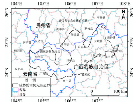
Fig.1 Location of the study area图1 桂西黔南生物多样性保护优先区地理位置 |
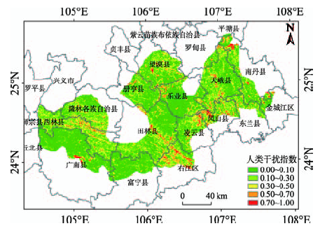
Fig.2 Human disturbance index of biodiversity conservation priority area in western Guangxi and southern Guizhou in 2000图2 桂西黔南优先区2000年人类干扰指数空间分布 |
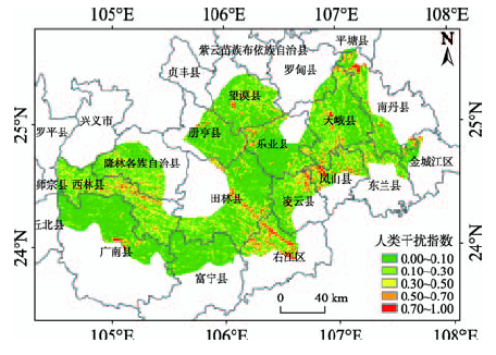
Fig.3 Human disturbance index of biodiversity conservation priority area in western Guangxi and southern Guizhou in 2010图3 桂西黔南优先区2010年人类干扰指数空间分布 |
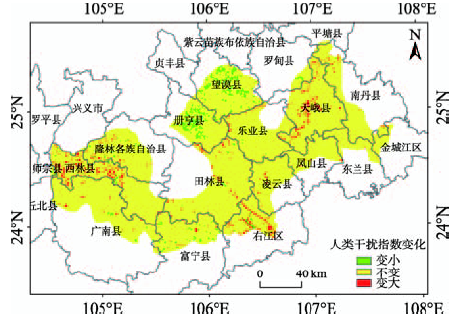
Fig.4 The change of human disturbance from 2000 to 2010图4 优先区人类干扰变化空间分布(2000-2010年) |
Tab.4 Results of human disturbance assessment in western Guangxi and southern Guizhou表4 桂西黔南区人类干扰评价结果 |
| 年份 | 微度 | 轻度 | 中度 | 重度 | 极重度 |
|---|---|---|---|---|---|
| 2000 | 55.87 | 27.20 | 10.45 | 4.60 | 1.89 |
| 2010 | 56.50 | 26.71 | 10.32 | 4.53 | 1.94 |
Tab.5 Change of human disturbance in western Guangxi and southern Guizhou表5 桂西黔南区人类干扰变化 |
| 时期 | 减小 | 不变 | 增大 |
|---|---|---|---|
| 2000-2010 | 3.27 | 93.70 | 3.01 |
The authors have declared that no competing interests exist.
| [1] |
中国生物多样性保护战略与行动计划(2011-2030年)[M].北京:中国环境科学出版社,2011.
[ National biodiversity strategy and action plan (2011-2030)[M]. Beijing: China Environmental Science Press, 2011. ]
|
| [2] |
|
| [3] |
|
| [4] |
[
|
| [5] |
[
|
| [6] |
[
|
| [7] |
[
|
| [8] |
[
|
| [9] |
[
|
| [10] |
[
|
| [11] |
[
|
| [12] |
[
|
| [13] |
[
|
| [14] |
[
|
| [15] |
[
|
| [16] |
[
|
| [17] |
[
|
| [18] |
[
|
| [19] |
[
|
| [20] |
[
|
| [21] |
[
|
| [22] |
[
|
| [23] |
[
|
| [24] |
[
|
| [25] |
[
|
| [26] |
[
|
| [27] |
[
|
/
| 〈 |
|
〉 |