
Journal of Geo-information Science >
Continuous Multi-scale Transformation of Urban Road Networks
Received date: 2015-12-02
Request revised date: 2016-03-16
Online published: 2016-09-27
Copyright
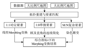
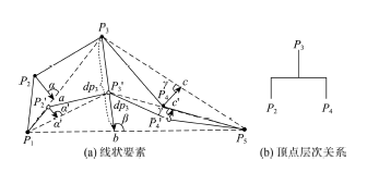
Presently, with the emergence of online mapping and Location Based Serveries (LBS), the continuous multi-scale representation of geo-spatial data has become a critical issue in the era of cartography and Geographic Information Science (GIS). This paper proposes a continuous transformation approach for the smooth representation of multi-scale road networks. Firstly, the topological relationships between the multi-scale road networks are reconstructed, and the feature correspondences are identified and classified into three categories (i.e., 1:1 matching features, 1:0 singleton features and M:N complex features) based on a probabilistic relaxation algorithm. For the 1:1 matching features, the corresponding points are identified based on the identical accumulated length ratio calculated from their starting vertex. The middle-scale representation of the 1:1 matching features is interpolated along the straight lines between the corresponding vertexes. For the 1:0 singleton features, considering that some road features are represented as a set of turns having approximately right angles, all the road vertexes containing an approximately right angle are detected and the edges connecting those vertexes are categorized into two characteristic sub-segments regarding as the left and right sides, which are then extended under the continuous direction. Then, the starting and ending nodes of the two characteristic sub-segment sets are selected to split the original road features into a set of divided line segments. Furthermore, the Douglas-Peucker algorithm is introduced to construct a hierarchical tree structure for each of the divided line segment, and all the divided line segments are hierarchically simplified by continuously moving the inner vertexes into the hierarchical tree structure. Moreover, the M:N complex features are visualized in gradually faded colors for a smooth representation. Finally, the continuous transformation results of different matching categories are integrated with respect to a given scale factor t. The experimental results have shown that the proposed approach can achieve a good performance for the continuous representation of the multi-scale urban road networks.
XIE Kun , DENG Min , ZHANG Yunfei . Continuous Multi-scale Transformation of Urban Road Networks[J]. Journal of Geo-information Science, 2016 , 18(9) : 1160 -1166 . DOI: 10.3724/SP.J.1047.2016.01160
Fig. 1 The framework of the proposed approach图1 本文方法流程图 |
Fig. 2 The result of linear Morphing method图2 线性Morphing变换结果 |
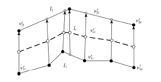
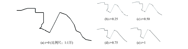
Fig. 3 The continuous generation of singleton linear features图3 线状要素连续简化变形 |
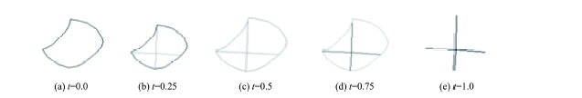
Fig. 4 Special occasions图4 特殊情况 |
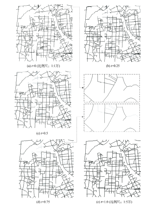
Fig. 5 The experimental results of the practical experimental data图5 实际算例实验结果 |
Fig. 6 The generalization result of road features considering the right angle feature图6 顾及直角特征的连续变换方法实验结果 |
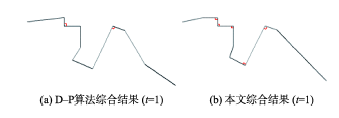
Fig. 7 The comparison between the commonapproach and the proposed approach图7 普通线状要素连续变换方法与本文方法实验结果对比 |
Fig. 8 The result of the fade-out method图8 染色淡出方法结果 |
The authors have declared that no competing interests exist.
| [1] |
[
|
| [2] |
|
| [3] |
|
| [4] |
|
| [5] |
|
| [6] |
[
|
| [7] |
[
|
| [8] |
[
|
| [9] |
[
|
| [10] |
|
| [11] |
|
| [12] |
[
|
| [13] |
|
| [14] |
|
| [15] |
|
| [16] |
[
|
| [17] |
|
/
| 〈 |
|
〉 |