
Journal of Geo-information Science >
A Comparative Study on Building Height Extraction Based on the Shadow Information in High Resolution Remote Sensing Image and Stereo Images.
Received date: 2015-08-04
Request revised date: 2015-11-10
Online published: 2016-09-27
Copyright
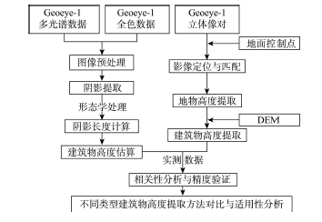
The accurate and quick acquisition of building height information has great significance to urban planning management and ecological environment assessment. In this paper, Geoeye-1 remotely sensed stereo images combined with the Google Earth data are used to estimate the building heights in Nanjing's central urban area by methods of single scene image and stereo images respectively, which are further validated using the field measured building heights. Firstly, after extracting the building shadow information by threshold segmentation and morphological optimization method, the building height can be calculated according to the geometric relationships between the sun, the satellite and the building. Secondly, the rational function model of stereo images is established based on the mathematical relationship between the three dimensional coordinates of the ground points and the coordinates of their corresponding image points in the image plane coordinate system, which can be further optimized using the measured ground control points data. The actual building height is then calculated by subtracting the terrain height from the height got from the rational function model. Finally, the measured building height data is used to validate the precision of the calculated results from two different methods. Furthermore, this paper compares the advantages and disadvantages of these two methods and analyzes their application precisions with respect to different building types. Results show that the method based on the stereo images is more accurate with a root mean square error within 2.8 m. The method of calculating building height through stereo images proves to be more practical because it obtains the building height information more quickly and accurately. The method of extracting building height using the shadow information from single image is suitable for tall buildings without shelter and keeping a long distance from the nearby buildings, while the method from stereo images is not affected by the surrounding buildings and is more capable for the condition of intensive building distribution with uniform heights.
Key words: remote sensing; high resolution images; image shadow; stereo images; building height
CHEN Ting , ZHU Shanyou , ZHANG Guixin , GAO Yang . A Comparative Study on Building Height Extraction Based on the Shadow Information in High Resolution Remote Sensing Image and Stereo Images.[J]. Journal of Geo-information Science, 2016 , 18(9) : 1267 -1275 . DOI: 10.3724/SP.J.1047.2016.01267
Fig.1 Flowchart of building height extraction图1 建筑物高度提取流程图 |
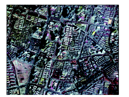
Fig.2 False color composite image of the study area图2 研究区假彩色合成图 |
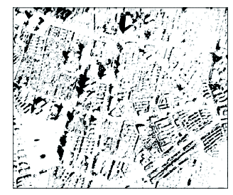
Fig.3 Image of shadow extraction results图3 阴影提取结果图 |
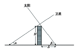
Fig.4 Geometric relationships between sun, satellite and buildings图4 太阳、卫星、建筑物几何关系 |
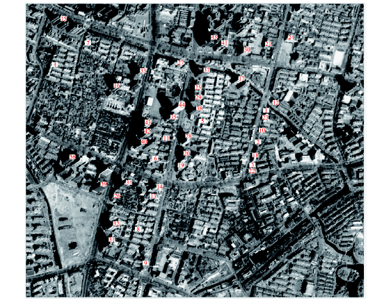
Fig.5 The distribution image of measured sample buildings图5 实测建筑物样点分布图 |
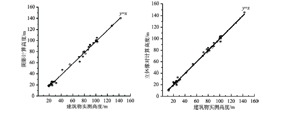
Fig.6 The relationship between the calculated building height and the measured building height图6 计算高度与实测高度关系图 |
Tab.1 RMSE of the building height estimation for different building types (m)表1 不同类型建筑物高度估算均方根误差(m) |
| 建筑物类型 | 阴影方法 | 立体像对方法 |
|---|---|---|
| 居民住宅建筑 | 4.4 | 2.5 |
| 商业建筑 | 3.1 | 2.8 |
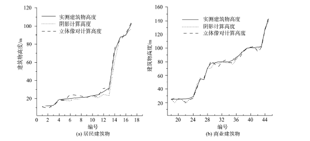
Fig.7 Contrast of the building height extraction results for different building types图7 不同类型建筑物高度提取结果对比图 |
The authors have declared that no competing interests exist.
| [1] |
[
|
| [2] |
[
|
| [3] |
|
| [4] |
[
|
| [5] |
[
|
| [6] |
[
|
| [7] |
[
|
| [8] |
[
|
| [9] |
[
|
| [10] |
[
|
| [11] |
[
|
| [12] |
[
|
| [13] |
[
|
| [14] |
[
|
| [15] |
[
|
| [16] |
|
| [17] |
[
|
| [18] |
[
|
| [19] |
[
|
| [20] |
[
|
| [21] |
[
|
| [22] |
[
|
/
| 〈 |
|
〉 |