
Journal of Geo-information Science >
Land Cover Mapping and Spatial Pattern Analysis with Remote Sensing in Nepal
Received date: 2015-03-16
Request revised date: 2015-04-30
Online published: 2016-10-25
Copyright
Nepal, located in the core region of the Hindu-Kush-Himalayan region, has complicated and diverse land cover classes. Meanwhile, its topography shows a typical transition pattern from plain to mountain, and then to plateau. Land cover mapping of Nepal not only has a great scientific and practical significance to its land resource management and eco-environmental protection, but also contributes greatly to the basic data collection in this area, which will support China’s international regional economic cooperation strategy of “the Belt and Road Initiative”. In this paper, the land cover product of Nepal in 2010 (hereinafter referred to as the NepalCover-2010) was produced from Landsat TM image data sources, based on the combined cartographic method of object-oriented methods and decision trees. The product contains 8 primary categories and 32 secondary categories. Besides, the accuracy validation of the NepalCover-2010 was performed using samples obtained from high-resolution Google Earth imagery. The quantitative structural characteristics of Nepal and the relationships between the spatial distribution of typical land cover classes and the topographical and meteorological elements were analyzed. The results demonstrated that: (1) the overall accuracies of the primary and secondary categories for the NepalCover-2010 are 94.83% and 87.17% respectively. The Kappa coefficients are 0.94 and 0.85 respectively. The NepalCover-2010 can reflect the spatial distribution characteristics of land covers in Nepal. The comparison between the NepalCover-2010 with similar land cover products indicated that the NepalCover-2010 has the best accuracy. (2) Forest is the major land cover class in Nepal, and it accounts for 41% of the total land area of Nepal. Cultivated land accounts for 25% and the area ratio of paddy field to dry land is about 2:3. (3) The topographical and meteorological elements impact greatly on the spatial distribution of land cover classes. The spatial distribution of each land cover class possesses the characteristics of vertical zonality, and the appearance pattern of the typical land cover classes from the south to the north is paddy fields, evergreen broadleaf forests, dry lands, evergreen broadleaf shrubs, evergreen needleleaf forests, steppes, sparse vegetation, snow and ice, along with the increase in altitude.
Key words: the Belt and Road Initiative; Nepal; land cover; spatial pattern; remote sensing
CAO Xiaomin , LI Ainong , LEI Guangbin , TAN Jianbo , ZHANG Zhengjian , YAN Dong , XIE Han , ZHANG Shuaiqi , YANG Yongshuai , SUN Mingjiang . Land Cover Mapping and Spatial Pattern Analysis with Remote Sensing in Nepal[J]. Journal of Geo-information Science, 2016 , 18(10) : 1384 -1398 . DOI: 10.3724/SP.J.1047.2016.01384
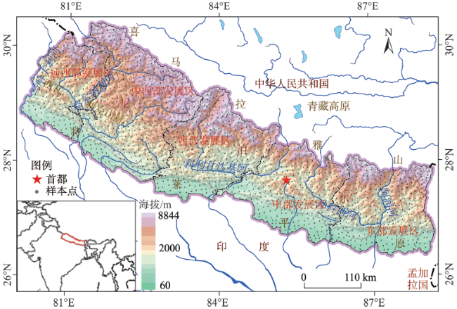
Fig. 1 The geographical location of Nepal and the spatial distribution of the validation samples图1 尼泊尔的地理位置和验证样本点空间分布 |
Fig. 2 The Landsat TM images used for producing the NepalCover-2010 product图2 NepalCover-2010产品生产采用的Landsat TM影像 |
Tab. 1 The land cover classification system for Nepal表1 尼泊尔土地覆被分类系统 |
| Ⅰ级分类 | Ⅱ级分类 | 分类依据 |
|---|---|---|
| 林地 | 常绿阔叶林 | 自然或半自然植被,终年常绿,树冠浑圆,C>60%,H>5 m |
| 落叶阔叶林 | 自然或半自然植被,冬季落叶,夏季葱绿,树冠浑圆,C>60%,H>5 m | |
| 常绿针叶林 | 自然或半自然植被,终年常绿,针状叶,C>60%,H>5 m | |
| 落叶针叶林 | 自然或半自然植被,冬季落叶,夏季葱绿,针状叶,C>60%,H>5 m | |
| 针阔混交林 | 自然或半自然植被,C>60%,H>5 m,针阔比率大于25%,小于75%。 | |
| 乔木绿地 | 人工植被,位于人工表面周围,C>60%,H>5 m | |
| 灌木林 | 常绿阔叶灌木林 | 自然或半自然植被,终年常绿,树冠浑圆,20%<C<40%,0.3m<H<5 m |
| 落叶阔叶灌木林 | 自然或半自然植被,冬季落叶,夏季葱绿,树冠浑圆,20%<C<40%,0.3 m<H<5 m | |
| 常绿针叶灌木林 | 自然或半自然植被,终年常绿,针状叶,20%<C<40%,0.3 m<H<5 m | |
| 灌木绿地 | 人工植被,位于人工表面周围,20%<C<40%,0.3 m<H<5 m | |
| 草地 | 草甸 | 自然或半自然植被,水生,C>20%,0.03 m<H<3 m |
| 草原 | 自然或半自然植被,旱生或中旱生,C>20%,0.03 m<H<3 m | |
| 草丛 | 自然或半自然植被,C>20%,0.03 m<H<3 m | |
| 草本绿地 | 人工植被,位于人工表面周围,C>20%,0.03 m<H<3 m | |
| 湿地 | 草本湿地 | 自然或半自然植被,以季节半生浮水植物为主的淡水沼泽,C>20%,0.03 m<H<3 m |
| 湖泊 | 自然水面,静止,蓄水功能 | |
| 水库/坑塘 | 人工水面,静止,蓄水功能 | |
| 河流 | 自然水面,线性流动 | |
| 运河/水渠 | 人工水面,流动,输水、分洪、排涝、给水等功能 | |
| 河漫滩 | 自然形成,位于河流周围,洪水期淹没,枯水期出露 | |
| 耕地 | 水田 | 人工植被,土地扰动,以水生作物为主,兼有水旱轮作方式,收割过程 |
| 旱地 | 人工植被,土地扰动,以旱生、抗旱作物为主,收割过程 | |
| 乔木园地 | 人工植被,具有经济效益,C>60%,H>5 m | |
| 灌木园地 | 人工植被,20%<C<40%,0.3 m<H<5 m | |
| 人工表面 | 居住地 | 人工硬表面,居住建筑 |
| 工业用地 | 人工硬表面,生产建筑 | |
| 交通用地 | 人工硬表面,线状地物 | |
| 采矿场 | 人工挖掘形成的采坑、台阶和露天沟道等 | |
| 裸露地 | 稀疏植被 | 自然或半自然植被,4%<C<20%,0.03 m<H<3 m |
| 裸岩 | 自然形成,裸露坚硬地表,无植被生长 | |
| 裸土 | 自然形成,裸露壤质地表,植被稀少 | |
| 冰川/永久积雪 | 冰川/永久积雪 | 自然形成,固体水库,终年覆盖地表 |
注:C代表覆盖度/郁闭度(%);H代表植被高度(m) |
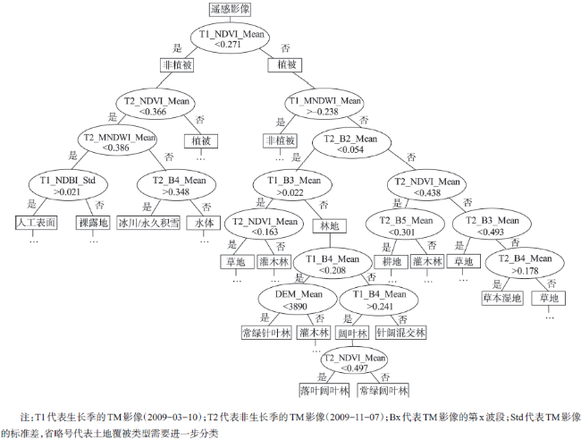
Fig. 3 The classification rule sets in decision tree for typical land cover classification图3 典型土地覆被类型分类的决策树分类规则集 |
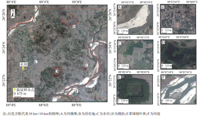
Fig. 4 A diagram showing that the maximum area method is used in selecting the validation samples on the platform of Google Earth图4 面积占优法选取验证样本点 |
Fig. 5 The final NepalCover-2010 product图5 2010年尼泊尔土地覆被 |
Tab. 2 Error matrix of the Nepal land cover map表2 土地覆被分类结果的误差矩阵 |
| 验证点 | 土地覆被类型 | ||||||||||||||||||
|---|---|---|---|---|---|---|---|---|---|---|---|---|---|---|---|---|---|---|---|
| A | B | C | D | E | F | G | H | I | J | K | L | M | N | O | P | 总计 | 制图精度/(%) | ||
| A | 188 | 8 | 3 | 4 | 1 | 204 | 92.16 | ||||||||||||
| B | 85 | 2 | 1 | 1 | 89 | 95.51 | |||||||||||||
| C | 27 | 1 | 163 | 3 | 1 | 195 | 83.59 | ||||||||||||
| D | 4 | 1 | 21 | 6 | 32 | 65.63 | |||||||||||||
| E | 2 | 6 | 33 | 2 | 3 | 46 | 71.74 | ||||||||||||
| F | 3 | 12 | 1 | 2 | 18 | 66.67 | |||||||||||||
| G | 11 | 11 | 100.00 | ||||||||||||||||
| H | 134 | 5 | 6 | 3 | 148 | 90.54 | |||||||||||||
| I | 13 | 2 | 15 | 86.67 | |||||||||||||||
| J | 12 | 12 | 100.00 | ||||||||||||||||
| K | 3 | 1 | 142 | 14 | 160 | 88.75 | |||||||||||||
| L | 11 | 4 | 4 | 5 | 2 | 3 | 2 | 16 | 328 | 375 | 87.47 | ||||||||
| M | 1 | 26 | 27 | 96.30 | |||||||||||||||
| N | 1 | 9 | 39 | 1 | 50 | 78.00 | |||||||||||||
| O | 3 | 16 | 4 | 23 | 69.57 | ||||||||||||||
| P | 1 | 1 | 1 | 2 | 7 | 2 | 109 | 123 | 88.62 | ||||||||||
| 总计 | 235 | 96 | 179 | 28 | 48 | 13 | 17 | 157 | 15 | 13 | 161 | 357 | 26 | 50 | 16 | 119 | 1528 | ||
| 用户精度/(%) | 80.00 | 88.54 | 91.06 | 75.00 | 68.75 | 92.31 | 64.71 | 85.35 | 86.67 | 92.31 | 88.20 | 91.88 | 100.00 | 78.00 | 100.00 | 93.16 | |||
| 总体分类精度/(%) 87.17 Kappa系数 0.85 | |||||||||||||||||||
注:A为常绿阔叶林;B为落叶阔叶林;C为常绿针叶林;D为常绿阔叶灌木林;E为落叶阔叶灌木林;F为常绿针叶灌木林;G为草甸;H为草原;I为-河流;J为河漫滩;K为水田;L为旱地;M为居住地;N为稀疏植被;O为裸土;P为冰川/永久积雪 |
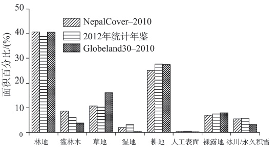
Fig. 6 The area proportion for each land coverclass in these three products图6 3种产品土地覆被类型面积百分比对比 |
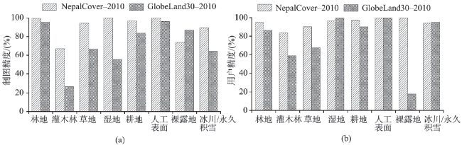
Fig. 7 The producer accuracy and the user accuracy for the NepalCover-2010 product and the GlobeLand30-2010 product图7 NepalCover-2010和GlobeLand30-2010制图精度和用户精度对比 |
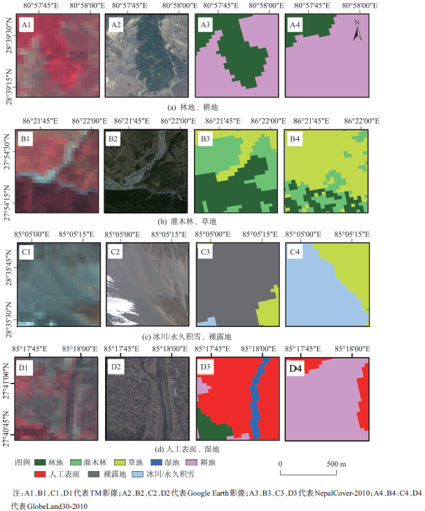
Fig. 8 Comparison of the results between the NepalCover-2010 product and the GlobeLand30-2010 product图8 NepalCover-2010和GlobeLand30-2010分类结果对比 |
Tab. 3 The area and proportion for each land cover class in the Nepal land cover map in 2010表3 尼泊尔2010年土地覆被类型的面积及比例 |
| Ⅰ级分类 | 面积/(km2) | 比例/(%) | Ⅱ级分类 | 面积(km2) | 比例/(%) | Ⅰ级分类 | 面积/(km2) | 比例/(%) | Ⅱ级分类 | 面积/(km2) | 比例/(%) |
|---|---|---|---|---|---|---|---|---|---|---|---|
| 林地 | 60 009.27 | 40.66 | 常绿阔叶林 | 26 794.78 | 18.16 | 湿地 | 2945.41 | 2.00 | 草本湿地 | 101.56 | 0.07 |
| 落叶阔叶林 | 8 965.31 | 6.08 | 湖泊 | 71.77 | 0.05 | ||||||
| 常绿针叶林 | 23 803.30 | 16.13 | 水库/坑塘 | 42.08 | 0.03 | ||||||
| 针阔混交林 | 440.75 | 0.30 | 河流 | 1057.57 | 0.72 | ||||||
| 乔木绿地 | 5.14 | 0.00 | 运河/水渠 | 17.05 | 0.01 | ||||||
| 灌木林 | 12 811.13 | 8.68 | 常绿阔叶灌木林 | 5 271.21 | 3.57 | 河漫滩 | 1655.37 | 1.12 | |||
| 落叶阔叶灌木林 | 6 224.20 | 4.22 | 人工表面 | 512.67 | 0.35 | 居住地 | 427.35 | 0.29 | |||
| 常绿针叶灌木林 | 1 314.64 | 0.89 | 工业用地 | 4.61 | 0.00 | ||||||
| 灌木绿地 | 1.07 | 0.00 | 交通用地 | 79.07 | 0.05 | ||||||
| 草地 | 15 898.78 | 10.77 | 草甸 | 1 533.97 | 1.04 | 采矿场 | 1.65 | 0.00 | |||
| 草原 | 13 880.24 | 9.41 | 裸露地 | 10 29.96 | 7.00 | 稀疏植被 | 6978.82 | 4.73 | |||
| 草丛 | 475.67 | 0.32 | 裸岩 | 373.14 | 0.25 | ||||||
| 草本绿地 | 8.90 | 0.01 | 裸土 | 2978.01 | 2.02 | ||||||
| 耕地 | 36 901.96 | 25.01 | 水田 | 13 938.75 | 9.45 | 冰川/永久 积雪 | 8160.79 | 5.53 | 冰川/永久 积雪 | 8160.79 | 5.53 |
| 旱地 | 22 846.88 | 15.48 | |||||||||
| 乔木园地 | 114.90 | 0.08 | |||||||||
| 灌木园地 | 1.43 | 0.00 |
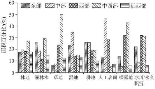
Fig. 9 The proportion of each land cover class's area in each development zone to the total area of this class图9 不同发展区土地覆被类型占该类型总面积比例 |
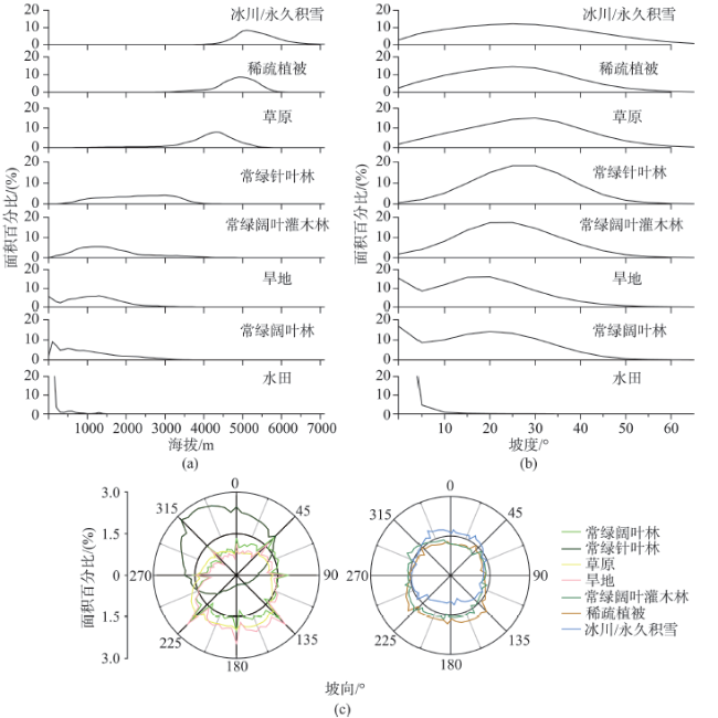
Fig. 10 Relationships between the spatial distribution patterns of typical land cover types and the topographical factors图10 典型土地覆被类型的空间分布格局与地形因子的关系 |
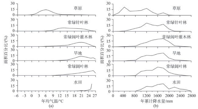
Fig. 11 Relationships between the spatial distribution patterns of typical land cover types and the meteorological elements图11 典型土地覆被类型的空间分布格局与气象要素的关系 |
The authors have declared that no competing interests exist.
| [1] |
|
| [2] |
|
| [3] |
[
|
| [4] |
[
|
| [5] |
|
| [6] |
[
|
| [7] |
|
| [8] |
|
| [9] |
|
| [10] |
|
| [11] |
[
|
| [12] |
|
| [13] |
|
| [14] |
[
|
| [15] |
|
| [16] |
|
| [17] |
[
|
| [18] |
|
| [19] |
|
| [20] |
[
|
| [21] |
[
|
| [22] |
[
|
| [23] |
[
|
| [24] |
[
|
| [25] |
|
| [26] |
[
|
| [27] |
陈建军周成虎,
[
|
| [28] |
[
|
| [29] |
[
|
| [30] |
|
| [31] |
|
| [32] |
[
|
| [33] |
[
|
| [34] |
[
|
/
| 〈 |
|
〉 |
