
Journal of Geo-information Science >
Automatic Recognition of Fold Landform Types Based on Spatial Structure Pattern Matching
Received date: 2016-02-24
Request revised date: 2016-04-15
Online published: 2016-11-20
Copyright
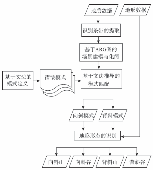
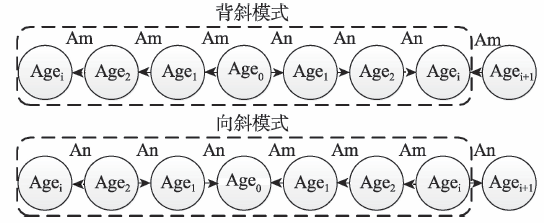
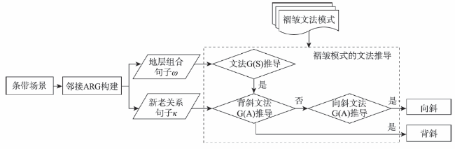
The automatic recognition of fold structure is one of the bases of tectonic interpretation, geomorphology classification and three-dimensional geological modeling. At present, most of the automatic recognition methods used for landform classification are based on the regular statistical unit. These methods, although effectively extract the characteristic landform by using image or terrain data, cannot recognize the tectonic landforms which combined the structural feature and topographical feature. As one of the most general tectonic landforms, fold landform has featured a symmetric repetitive spatial structure, which can be used to recognize the fold. To realize the automatic recognition of fold landform types, this research provides a method based on the spatial structure pattern matching. This method focuses on building scene models of fold structures by using Attributed Relational Graph (ARG) and identifying the fold landform types by defining different spatial structure patterns through the formal grammar. The implementation process is presented as follows. Firstly, extract the long strip scene that may contain the fold structure according to the principles used in choosing fold cores and section lines. Secondly, build and simplify the spatial structure model of the long strip scene by following the ARG approach. Thirdly, convert the ARG model into sentences, and classify the fold types with respect to different grammatical inferences of the sentences. If the sentences cannot be inferred by Anticline Grammar and Syncline Grammar, then it is not a fold. Fourthly, determine the fold landform types by checking whether the terrain containing the fold is a mountain or a valley. The result shows that the proposed method is capable for automatically recognizing the fold landform types in the northern Lushan area. It basically solves the problem in the auto-recognizing of fold landform types for mountainous area, and can be a supplementary reference to the traditional methods used for landform classification.
CHEN Ying , LI Anbo , YAO Mengmeng , LU Guonian . Automatic Recognition of Fold Landform Types Based on Spatial Structure Pattern Matching[J]. Journal of Geo-information Science, 2016 , 18(11) : 1500 -1512 . DOI: 10.3724/SP.J.1047.2016.01500
Fig.1 Framework of automatically recognition of fold landform types图1 褶皱地貌类型自动识别框架 |
Tab.2 Rules for identifying core stratums表2 核部地层识别规则 |
| 自然语言描述 | 形式化语言描述 | 示例 |
|---|---|---|
| 地层S相对所有邻接地层S邻年代较老或较新 | If IsOld(S,S邻) = Ture Or IsNew(S,S邻) = Ture Then IsCore(S) = Ture | 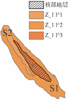 |
| 地层S基本被某邻接地层S邻环绕而内部不存在洞(岛) | If IsSurrounded (S,S邻) = Ture Then IsCore(S) = Ture |  |
| 地层S的邻接地层S邻集合中存在地层符号属性一致的地层 | If HasSameAge(S邻) Then IsCore(S) = Ture |  |
Fig.2 Example of a scene modeling图2 场景建模示例 |
Fig.3 Conceptual model of fold scene based on ARG图3 基于ARG的褶皱场景概念模型 |
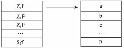
Fig.4 Mapping stratigraphic units to a table图4 地层年代映射表 |
Fig.5 Pattern matching process of fold structure图5 褶皱构造模式的匹配流程 |
Tab.4 Simplification scheme of adjacent ARG model表4 场景邻接ARG模型的化简方案 |
| 情景 | 邻接ARG示例 | 示例描述 | 化简方案 | |
|---|---|---|---|---|
| 化简前 | 化简后 | |||
| 化简对象位于属性不同的2个对象之间 |  | 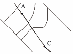 | 化简对象B与对象A、C邻接,A与C属性不同 | 剔除B,剔除关系AB、BC,更新对象A和C的坐标,以及关系AC |
| 化简对象位于属性相同的2个对象之间 | 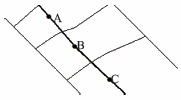 | 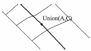 | 化简对象B与对象A、C邻接,A与C属性相同同 | 剔除B,剔除关系AB、BC,合并对象A和C,更新与A、C关联的关系 |
| 化简对象有多于2个邻接对象 | 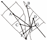 | 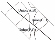 | 化简对象E与对象A、B、C、D、F与G相邻,A与B属性相同且方位与地层走向一致,C与D,F与G情况同上 | 剔除E,剔除关系AE、BE、CE、DE、FE和GE,合并A与B、C与D、F与G,更新与A、B、C、D、F、G关联的关系 |
Tab.5 Example of the pattern matching of fold structure表5 褶皱构造模式匹配示例 |
| 示例 | 句子 | 待推导子句 | 推导过程 | 结果 |
|---|---|---|---|---|
示例1 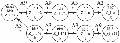 | jdabcbadg llrrllrr | bcb rl | S→bcb A→rl | 201 向斜 |
| abcba rrll | S→aSa→abcba A→rAl→rrll | 42013 向斜 | ||
| dabcbad lrrllr | S→dSd→daSad→dabcbad 不符合文法G(A) | 输出42013 向斜 | ||
示例2 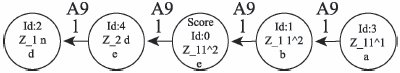 | edcba llll | dcb ll | 不符合文法G(S) 不符合文法G(A) | 输出 非褶皱 |
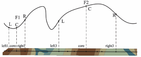
Fig.6 Classification of terrain with fold structure图6 褶皱构造地形判别 |
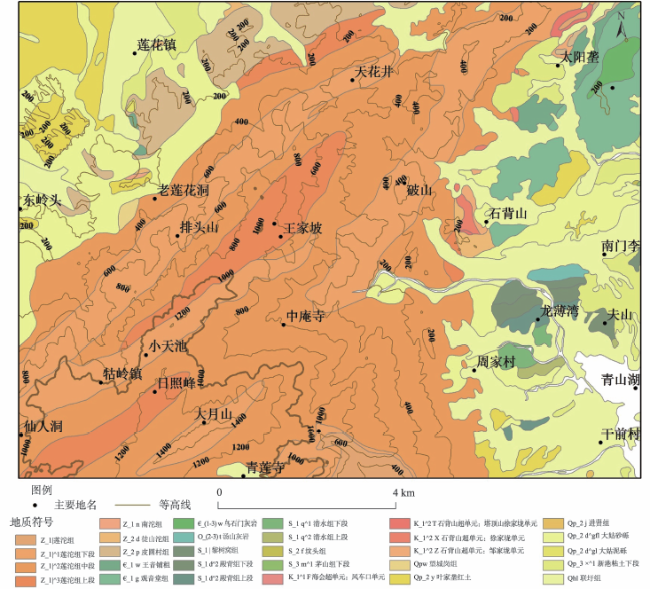
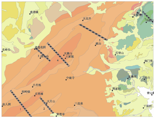
Fig.7 Experimental data图7 实验数据(庐山北部区域地形地质图) |
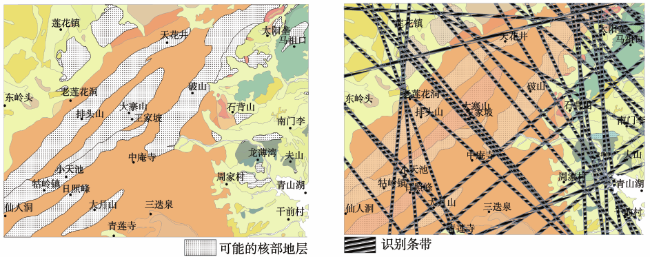
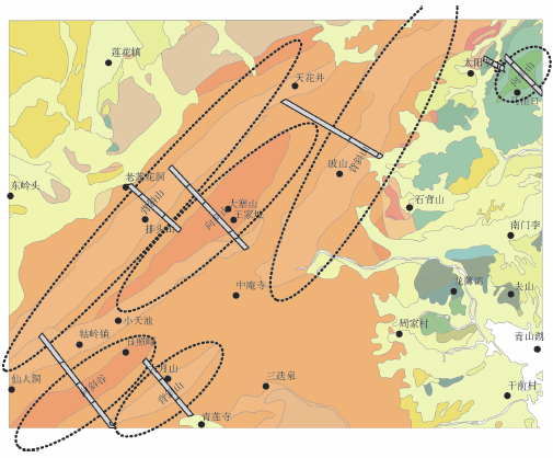
Fig.8 Result of scene extraction图8 场景提取结果 |
Tab.6 Fold structure′s matching result表6 褶皱构造匹配结果 |
| 编号 | 句子 | 匹配部分 | 结果 |
|---|---|---|---|
| 1 | cbcdcblrrll | bcdcbrrll | 向斜 |
| 2 | cbcdbcdcbclrrlrrllr | cbclr | 背斜 |
| 3 | fecbcdbcrllrrlr | cbclr | 背斜 |
| 4 | gcbcdcbcbcllrrllrlr | bcdcbrrll | 向斜 |
| 5 | fgdcbcbcilrlllrlrrr | cbclr | 背斜 |
| 6 | cbghjhijilrrrlrrl | hjhrl | 向斜 |
| 7 | baghjhijilrrrlrlr | ijirl | 向斜 |
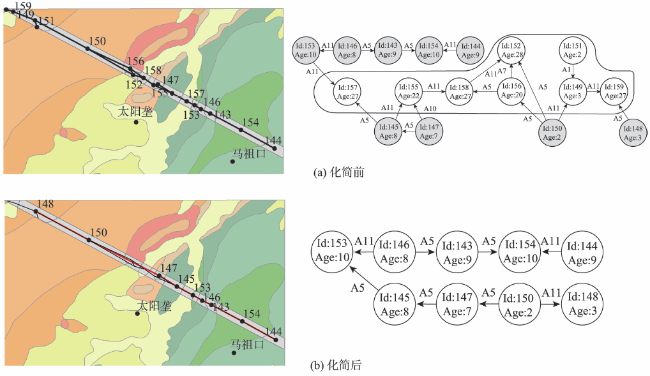
Fig.9 Simplification of adjacent ARG model图9 邻接ARG场景模型的化简 |
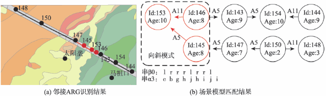
Fig.10 Example of fold pattern matching图10 褶皱构造模式匹配示例 |
Fig.11 Identification result图11 褶皱构造场景条带识别结果 |
Fig.12 Marking the fold landforms图12 褶皱地貌类型标注 |
Fig.13 Fold axis in the experimental area图13 实验区褶皱轴迹[42] |
The authors have declared that no competing interests exist.
| [1] |
|
| [2] |
[
|
| [3] |
|
| [4] |
[
|
| [5] |
[
|
| [6] |
[
|
| [7] |
[
|
| [8] |
[
|
| [9] |
[
|
| [10] |
[
|
| [11] |
|
| [12] |
[
|
| [13] |
[
|
| [14] |
[
|
| [15] |
[
|
| [16] |
[
|
| [17] |
[
|
| [18] |
|
| [19] |
|
| [20] |
[
|
| [21] |
[
|
| [22] |
|
| [23] |
|
| [24] |
[
|
| [25] |
|
| [26] |
|
| [27] |
|
| [28] |
|
| [29] |
[
|
| [30] |
[
|
| [31] |
|
| [32] |
|
| [33] |
|
| [34] |
|
| [35] |
|
| [36] |
|
| [37] |
[
|
| [38] |
[
|
| [39] |
[
|
| [40] |
[
|
| [41] |
中华人民共和国地质矿产部. DZ/T 0197-1997, 中华人民共和国地质矿产行业标准[S].北京:中国标准出版社,1998.
[ DZ/T 0197-1997Z/T 0197-1997. Standard of the People's Republic of China on the Geological and Mineral Industry[S]. Beijing: China Standard Press, 1998. ]
|
| [42] |
海会幅地质图说明书[R].会幅地质图说明书[R].江西地质矿产勘查开发局,1994:54-55.
[ Geological introduction of Haihui area[R].eological introduction of Haihui area[R]. Nanchang: Jiangxi Bureau of Geology and Mineral Resources, 1994:54-55. ]
|
/
| 〈 |
|
〉 |

