
Journal of Geo-information Science >
Remote Sensing Estimation of the Carbon Balance Ability Based on the Object-Oriented Method for Guangxi Youjiang District
Received date: 2016-01-14
Request revised date: 2016-04-06
Online published: 2016-12-20
Copyright
Global warming is one of the most daunting challenges that our humanity is facing. It has urged the action to study carbon emissions and carbon sequestration ability to control the regional climate change. Some studies show that human activities, especially the combustion of fossil fuel, cause the carbon emissions and the global climate warming. Therefore, it is important to work on energy saving and emission reduction. At the same time, the carbon sink capacity of forest, grassland, crops and other vegetations become one of the most powerful approaches to ease the global climate change. Thus, we conduct a research in this area, in order to improve the carbon source utilization efficiency, reduce the carbon intensity, prefect the energy-saving and emission-reduction works, and well manage the carbon budget capacity and some other problems. Taking Youjiang district of Baise city in Guangxi Province as the experimental area, this article uses the object-oriented classification technology and extracts the area geographic information from the Landsat 8 OLI and Google Earth images. Due to the complex terrain of the study area, different parameter settings of the multi-scale segmentation are used and the optimal scaling for the image segmentation is selected. We also use the membership function method, the closest classification method and the CART decision tree classifier method to complete the object-oriented classification layer by layer and evaluate the accuracy of the classification results, based on the spectral difference, geometric shapes, objects, texture and other characteristics. Through summarizing the conversion relationship between the land and carbon coefficient, combining with the high-precision object-oriented classification results, the estimation model of carbon budget capacity is built based on land-cover types. Finally, according to the CASA model of carbon budget capacity, we check the accuracy of the estimation method. The carbon budget capacity of Youjiang district is estimated to be -3996.4 kt, according to the coefficient that corresponds to the feature carbon conversion relationship. Integrated with the administrative planning, population distribution, DEM, and other relevant data, the carbon budget capacity of Youjiang district is analyzed thematically. The results showed that: (1) the use of RS and GIS technologies in the studies of regional carbon budget capacity reveals a distinct advantage. The multiscale segmentation and object classification method can efficiently eliminate the extraction error caused by spectral confusion, and solve problems such as the large quantity of spatial data faced by the traditional classification, the classification of "salt and pepper", the exact utilization of different classification methods, and the improvement of the classification accuracy of carbon. (2) We summarized the findings of the coefficients for carbon balance capacity from domestic and international researches, and applied it in the construction of carbon balance estimation model. The object-oriented method and carbon balance estimation model were used to interpret the land cover data to estimate the Youjiang area carbon balance capability. Results show that the high degree of forest land, grassland, cultivated land and other types of vegetation areas is responsible for the performance of carbon sink in the study area. At the same time the construction land consumes a lot of fossil fuel to play as a large source of carbon. But the overall carbon sink ability of Youjiang area is stronger than its carbon emissions. It is conducive to the stable development of the regional ecological system, and may ease the regional threat of climate change. (3) Combined with the administrative divisions of Youjiang district and DEM data, the spatial analysis was carried out. We summed up the overall characteristics of the carbon budget capacity in the Youjiang district. The carbon budget is large in quantity in the central districts. Moreover, studies have shown that the elevation, slope aspect and human activities could affect the carbon budget capacity. It specifically demonstrated that the areas of high-altitude, steep slopes and less human activity reveal a large amount of carbon sink and less carbon footprint. On the contrary, the areas of low-altitude, lower slopes and more human activity reveal a large carbon footprint and lower amount of carbon.
TONG Xinhua , ZHANG-GUO Qiuchen , WEI Yanfei . Remote Sensing Estimation of the Carbon Balance Ability Based on the Object-Oriented Method for Guangxi Youjiang District[J]. Journal of Geo-information Science, 2016 , 18(12) : 1675 -1683 . DOI: 10.3724/SP.J.1047.2016.01675
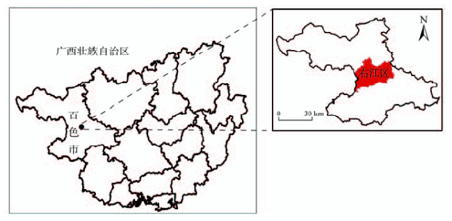
Fig.1 The location of the main study area图1 研究区位置图 |
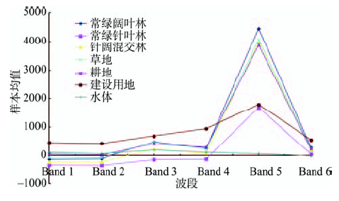
Fig.2 The sample spectral response curves of different object types图2 不同地物覆被类型样本的光谱特征响应曲线 |
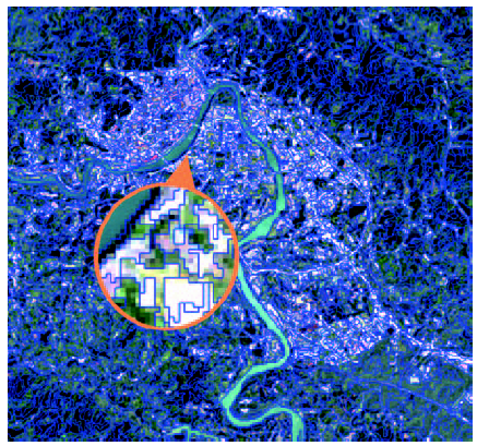
Fig.3 Result using the best parameter setting图3 最优分割参数结果图 |
Tab.1 Experiment zone’s land cover classification system for carbon budget表1 针对碳收支能力的研究区土地覆被分类体系 |
| 序号 | I级分类 | 代码 | Ⅱ级分类 |
|---|---|---|---|
| 1 | 林地 | 101 | 常绿阔叶林 |
| 103 | 常绿针叶林 | ||
| 105 | 针阔混交林 | ||
| 2 | 草地 | ||
| 3 | 耕地 | ||
| 4 | 建设用地 |
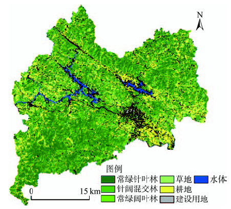
Fig.4 Classification results using the object-oriented method in Youjiang district图4 右江区面向对象分类方法分类结果 |
Tab.2 Error matrix of classification using the object-oriented method表2 面向对象分类方法的误差矩阵 |
| 常绿阔叶林 | 常绿针叶林 | 针阔混交林 | 草地 | 耕地 | 建设用地 | |
|---|---|---|---|---|---|---|
| 常绿阔叶林 | 552 | 3 | 13 | 82 | 56 | 27 |
| 常绿针叶林 | 4 | 2178 | 35 | 7 | 11 | 39 |
| 针阔混交林 | 26 | 22 | 541 | 5 | 6 | 15 |
| 草地 | 93 | 0 | 4 | 423 | 52 | 8 |
| 耕地 | 43 | 1 | 11 | 64 | 1026 | 17 |
| 建设用地 | 32 | 2 | 4 | 6 | 37 | 1479 |
| 总体精度/(% ) 89.53 Kappa系数 0.87 | ||||||
| 指标来源 | 煤消耗碳源系数/(t(C)/t) | 石油消耗碳源系数/(t(C)/t) | 天然气消耗碳源系数/(t(C)/t) | 常绿阔叶林碳汇系数/kg(c)m2·a-1 | 常绿针叶林碳汇系数/kg(c)m2·a-1 | 针阔混叶林碳汇系数/kg(c)m2·a-1 | 草地碳汇系数/kg(c)m2·a-1 | 农作物生产碳源系数/kg(c)m2·a-1 | 农作物生产碳汇系数/kg(c)m2·a-1 |
|---|---|---|---|---|---|---|---|---|---|
| 日本能源经济研究所 | 0.7560 | 0.5860 | 0.4490 | - | - | - | - | - | - |
| 国家科委气候变化项目 | 0.7260 | 0.5830 | 0.4090 | - | - | - | - | - | - |
| 徐国泉等 | 0.7476 | 0.5825 | 0.4435 | - | - | - | - | - | - |
| 汪刚 | 0.7260 | - | - | - | - | - | - | - | - |
| 谭丹 | 0.7329 | 0.5574 | 0.4426 | - | - | - | - | - | - |
| 何介男、ORNL | 0.7194 | 0.5849 | 0.4036 | - | - | - | - | - | - |
| DOE/EIA | 0.7020 | 0.4780 | 0.3890 | - | - | - | - | - | - |
| 国家计委能源局 | 0.6510 | 0.5430 | 0.4040 | - | - | - | - | - | - |
| 王东生 | 0.7201 | 0.5593 | 0.4201 | - | - | - | -0.0021 | 0.04255 | -0.692 |
| 何勇等 | - | - | - | - | - | - | - | 0.0422 | -0.692 |
| 方精云、郭兆迪等 | - | - | - | -10.096 | -4.15 | -6.53 | -0.0021 | - | - |
| cai zu-cong | - | - | - | - | - | - | - | 0.0429 | - |
| 本文采用均值 | 0.7201 | 0.5593 | 0.4201 | -10.096 | -4.15 | -6.53 | -0.0021 | 0.04255 | -0.692 |
注:正值为碳排放系数;负值为碳汇系数;-为缺省数据 |
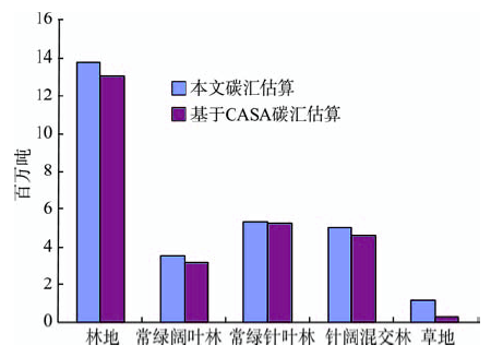
Tab.4 Carbon budget for different land use types in Youjiang district表4 右江区各地类碳收支能力汇总表 |
| I级类别 | II级类别 | 数值/t |
|---|---|---|
| 林地 | -13 797 899 | |
| 常绿阔叶林 | -3 501 021 | |
| 常绿针叶林 | -5 325 374 | |
| 针阔混交林 | -4 971 504 | |
| 草地 | -570 | |
| 耕地 | -19 761 | |
| 耕地碳排放 | 1295 | |
| 耕地碳汇 | -21 056 | |
| 建设用地 | 9 821 800 | |
| 煤碳排放 | 9 116 568 | |
| 石油碳排放 | 661 305 | |
| 天然气碳排放 | 43 927 | |
| 碳收支总量 | -3 996 430 | |
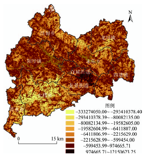
Fig.5 Thematic map of the carbon budget in Youjiang district图5 右江区碳收支能力专题图 |
Fig.6 Contrast check of the carbon sink in Youjiang district图6 右江区碳汇能力校验对比图 |
Tab.5 Information of the administrative divisions in Youjiang district表5 右江区行政区划信息统计表 |
| 乡、镇、街道 | 人口/万 | 碳收支总量/t |
|---|---|---|
| 百城街道 | 12.50 | 4328 |
| 阳圩镇 | 3.45 | -309 378 |
| 四塘镇 | 2.51 | -56 123 |
| 龙川镇 | 3.10 | -189 337 |
| 龙景街道 | 4.90 | -84 259 |
| 永乐镇 | 1.80 | -227 482 |
| 汪甸瑶族乡 | 2.38 | -176 999 |
| 大楞乡 | 2.20 | -2 407 722 |
| 泮水乡 | 0.97 | -549 456 |
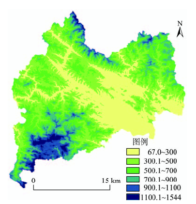
Fig.7 Elevation grading in Youjiang district图7 右江区高程分级图 |
Tab.6 Elevation grading of the carbon budget in Youjiang district表6 右江区高程分级碳收支能力统计表 |
| 分级类别 | 高程/m | 碳收支总量/t |
|---|---|---|
| 平原台地 | 0-300 | -67 443 |
| 丘陵 | 301-500 | -352 499 |
| 小起伏山地 | 501-700 | -995 164 |
| 中起伏低山 | 701-900 | -1 259 745 |
| 中起伏高山 | 901-1100 | -805 610 |
| 大起伏山地 | 1101-1544 | -515 969 |
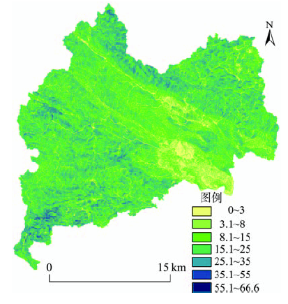
Fig.8 Slope classification in Youjiang district图8 右江区坡度类别分级图 |
Tab.7 Slope classification of the carbon budget in Youjiang district表7 右江区坡度分级碳收支能力统计表 |
| 坡度分级 | 坡度区域/ ゜ | 碳收支总量/t |
|---|---|---|
| 平坡 | 0-3 | -30 996 |
| 微坡 | 3.1-8 | -225 654 |
| 缓坡 | 8.1-15 | -782 647 |
| 斜坡 | 15.1-25 | -1 865 681 |
| 陡坡 | 25.1-35 | -940 406 |
| 急坡 | 35.1-55 | -149 443 |
| 险坡 | 55.1-66.6 | -1603 |
The authors have declared that no competing interests exist.
| [1] |
|
| [2] |
[
|
| [3] |
[
|
| [4] |
[
|
| [5] |
[
|
| [6] |
|
| [7] |
|
| [8] |
[
|
| [9] |
[
|
| [10] |
|
| [11] |
[
|
| [12] |
[
|
| [13] |
[
|
| [14] |
[
|
| [15] |
[
|
| [16] |
[
|
| [17] |
[
|
| [18] |
[
|
| [19] |
[
|
| [20] |
[
|
| [21] |
[
|
| [22] |
[
|
/
| 〈 |
|
〉 |