Orginal Article

An Algorithm of Snow Cover Fraction Retrieval Considering the Variability of Snow Particle Size

  • WANG Jie , 1 ,
  • HUANG Chunlin , 2, * ,
  • HAO Xiaohua 2
Expand
  • 1. College of Land and Resources, China West Normal University, Nanchong 637009,China
  • 2. Cold and Arid Regions Environmental and Engineering Research Institute, ChineseAcademy of Sciences, Lanzhou 730000, China
*Corresponding author: HUANG Chunlin, E-mail:

Received date: 2016-02-29

  Request revised date: 2016-06-19

  Online published: 2017-01-13

Copyright

《地球信息科学学报》编辑部 所有

Abstract

Snow-cover information is important for a wide variety of scientific studies, water supply and management applications. The NASA Earth Observing System (EOS) Moderate Resolution Imaging Spectroradiometer (MODIS) provides improved capabilities of observing snow cover from space and has been successfully using a normalized difference snow index (NDSI), along with threshold tests, to provide global automated binary maps of snow cover. NDSI and other classification algorithms were used to inverse subpixel information of Snow Cover Fraction (SCF), but these algorithms neglected the relation between SCF and Snow Grain Size (SGZ). The SGZ might affect snow reflectance spectral curves, while most subpixel classification algorithm took advantage of the spectral feature space. The collaborative inversion of SCF and SGZ helped improve the understanding of the physical properties of snow. Meanwhile, it was possible to improve the retrieval accuracy of SCF. The framework of spectral mixture analysis (SMA) was widely used in the target detection of remote sensing images because of its ability to extract subpixel information and SMA could use mathematical methods to model SCF with snow reflectance spectral curves with different snow grain sizes. In this paper, in view of the snow cover with MODIS remote sensing image, based on the framework of spectral mixture analysis, the snow reflectance spectral library with different grain sizes was built by asymptotic radiative transfer (ART) model, and a sparse unmixing algorithm of snow cover fraction retrieval was proposed considering the endmember variability of snow with other materials and bilinear radiative process of endmembers. The ART model had a higher efficiency compared with MIE scatter model. Meanwhile, ART model considered snow grain shape parameters. The majority algorithm of SMA assumed the endmembers independent, which might neglect the interaction of endmembers, while bilinear radiative process of endmembers could consider second-order scattering effects, which had physical meaning. This algorithm firstly used asymptotic radiative transfer model to establish reflectance spectral library with different grain sizes, and Sequential Maximum Angle Convex Cone (SMACC) endmember extraction algorithm was used to obtain the spectral library of vegetation, soil and rock shadow. After the establishment of a variety of spectral libraries, the root mean square error index was used to get the optimal combination of endmembers for each pixel as MODIS Snow Covered Area and Grain Sizes(MODSCAG) model, which could accurately describe the endmember variability. After the optimal endmembers combination obtained, the bilinear radiative process was added into sparse regression spectral mixture analysis to simultaneously obtain snow cover fraction and snow grain size. Experimental results showed that this method could simultaneously inverse the snow grain sizes and snow cover fraction, and the retrieved snow grain sizes is smaller than that from single band of asymptotic radiative transfer model The accuracy of retrieved snow cover fraction is increased slightly compared with MOD10A1 product.

Cite this article

WANG Jie , HUANG Chunlin , HAO Xiaohua . An Algorithm of Snow Cover Fraction Retrieval Considering the Variability of Snow Particle Size[J]. Journal of Geo-information Science, 2017 , 19(1) : 101 -109 . DOI: 10.3724/SP.J.1047.2017.00101

1 引言

积雪作为地球上重要的自然资源,对全球的能量平衡起重要的作用,成为冰冻圈科学研究的重要内容。雪反照率作为一个全球辐射平衡的重要参数,极大地影响着季节性与常年积雪地区的辐射 量[1]。遥感作为一种探测手段,能连续地获取大面积遥感影像,成为积雪科学重要的数据来源。积雪面积与雪粒径是积雪遥感中重要的参数,积雪面积的提取目前主要集中于光学遥感影像上,方法主要有阈值法[1],监督分类法[2]。雪粒径极大地影响了纯雪的光谱曲线,而积雪的光谱曲线对积雪面积的定量又产生作用,故雪粒径与积雪面积相互作用,应该将其当成一个整体进行系统的研究。针对雪粒径的反演,国内外学者较广泛使用的是渐进辐射传输模型[3-7]。目前,大多数学者仅从雪粒径或者积雪面积角度研究积雪,而针对雪粒径与积雪面积协同反演的算法较少。Painter采用多端元光谱混合分析算法[8](其发展成为MODSCAG模型)同时反演了积雪粒径与积雪面积[9-10],此方法考虑了积雪端元的变化,取得了较高的精度。MODSCAG模型虽然考虑到了端元变化,采用阴影规则化获取积雪面积,这对积雪面积的获取没有多大影响,但是对植被、土壤、岩石等具有较大的影响,可能产生较多的负数,而面积产生负数没有物理意义,同时阻碍了积雪与植被的关系研究。在MODSCAG模型中,采用MIE散射模型建立不同粒径大小的反照率光谱库,以及采用整个光谱库进行组合求取均方根误差,这里没有任何先验知识,导致其运行效率低下。
积雪粒径与积雪面积协同反演是目前发展的必然趋势,将雪粒径的变化整合进混合像元分解之中,提高分解的精度,是本文的主要目的。根据前面的论述,同时参考MODSCAG模型,引入稀疏算法,提出了一种考虑雪粒径变化的积雪面积反演算法。目前,积雪混合分解算法大多没有考虑积雪与植被或者土壤的多次散射效应,而积雪常常与植被或者土壤进行多次交互,多次散射的过程常常伴随于辐射传输过程之中,为此,本文中利用最小均方根误差指标获取最优端元组合,然后构建一个新的端元矩阵,此矩阵考虑积雪端元独立辐射、自身二次散射,以及与其它端元的二次散射情况。

2 研究区及遥感影像预处理

研究区选择黑河流域,流域范围为100°12′~100°18′ E,38°01′~38°04′ N,海拔3431~4401 m之间,平均海拔为3900 m[11]。流域具有明显垂直地带性的自然景观, 海拔2800~3300 m 为森林带,3400~3700 m是灌丛草甸带,海拔4000 m以上多为无植被的高山荒漠带,属中国西部高山高原多年冻土 区[12]。流域降水量丰富,年均降水量达774 mm,降水量年度分配不均匀,夏季(6-8月)集中了年降水量的64. 2%,春季(3-5月)占20.9%,秋季(9-11月)占12.9%,冬季(12月至翌年2月)仅占2.0%,属于大陆性气候。流域内积雪属于季节性积雪,深度平均约0.5 m,最深可达0.8~1.0 m[11-12]
遥感影像采用中等分辨率成像光谱仪(MODIS)表面反射率产品MOD09GA,此产品已经过严格的大气校正、几何校正和辐射校正,空间分辨率为500 m,包含1-7个波段(波长分别为620~670、841~876、459~479、545~565、1230~1250、1628~1652、2105~2155 nm)。为了验证反演的积雪面积,下载了同一天的TM影像,日期为2007年9月14日。将MODIS影像进行预处理,HDF格式的影像转换成ENVI标准格式,重新投影MOD09GA产品,使其与TM影像坐标一致。波段合并且按照波长升序排列各个波段,同时裁剪出研究区域。预处理后的TM与MODIS影像如图1所示。
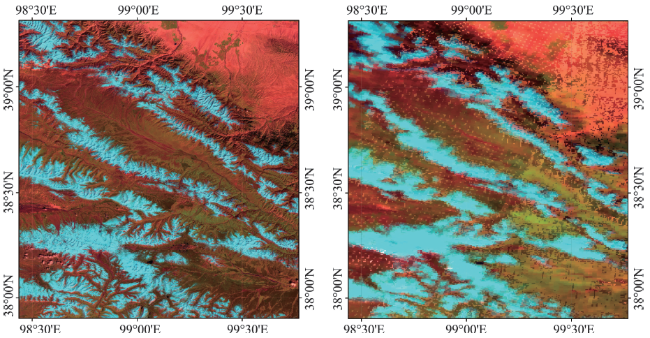
Fig. 1 The TM and MODIS images of the study region (7, 4, 1 bands)

图1 研究区2007年9月14日的TM与MOD09GA遥感影像(7、4、1波段组合)

3 建立光谱库及遥感影像校正

遥感影像上的积雪像元常常与植被、土壤、岩石、阴影混合,为了同时获取积雪粒径与面积,必须事先建立非雪端元光谱库。这里使用序贯最大角凸锥(简称SMACC)算法[13]帮助提取非雪的端元。SMACC算法包括3个输入参数,分别是端元的个数、均方根误差容限、面积系数的限制条件(3个限制条件包括非负、和为1、和小于或者等于1)。经过多次实验,发现这3个参数设置成70、0.06、非负限制时,能够准确地提取所需的端元矩阵,然后人机交互选择一些较为纯净的端元光谱。为了准确地获取非雪端元,MODIS影像归一化植被指数被使用,辅助选择纯净的端元。最终,光谱库包含15个植被端元,13个土壤与岩石端元,以及8个阴影端元。其中,积雪的光谱库没有事先建立,故采用第3节的方法动态地建立每个像元的积雪反射率光 谱库。
渐进辐射传输模型采用渐进的方法简化辐射传输,被广泛地应用于积雪粒径反演与反射率光谱库的建立[3-7]。由于积雪的光谱库通过辐射传输模型获取,其与MODIS影像获取尺度不同,导致MODIS影像上积雪反射率光谱与积雪光谱库中的光谱不匹配。为了解释这种现象的存在,采用渐进辐射传输模型中的Zege模型[5,7]建立不同粒径的积雪反射率光谱曲线(雪粒径形状参数仍然采用文中的5.8),如图2(a)所示。同时,选择数条反射率较高的MODIS影像积雪反射率光谱曲线,其中选择的依据为Zege模型反演的雪粒径和海拔高度,最终选取的结果如图2(b)所示。对比图2(a)与2(b)可知,光谱库与影像上的纯雪不匹配,如果直接用光谱库参与混合像元分解,会造成反演的积雪面积偏低。
为了消除光谱库与MODIS影像的不匹配现象,本文采用L2范数进行规则化校正,L2范数被广泛应用于遥感影像的规则化[14],以消除辐射传输模型获取的光谱与影像的不匹配问题。L2范数规则化相当于压缩了数据的特征空间,但是保持了数据在特征空间的相对位置,这对均方根误差最小化指标的求取没有太大的影响,这也可以从第4节的讨论中清楚地看出。对图2的光谱进行L2规则化,其结果分别为图3(a)与3(b)。经过L2规则化后,光谱库与遥感影像不匹配程度降低。同时,对植被、土壤与岩石、阴影光谱库分别进行L2规则化,其结果如图4所示。
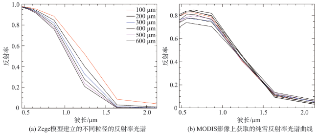
Fig. 2 The comparison between spectral library of radiative transfer model and spectral curves of MODIS images

图2 雪光谱库光谱与影像光谱对比

Fig. 3 L2 norm normalized spectral library of radiative transfer model and spectral curves of MODIS images

图3 L2范数对光谱库与影像进行规则化

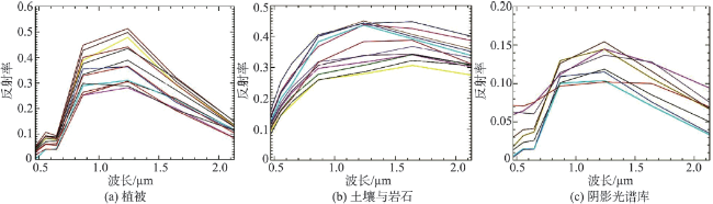
Fig.4 L2 norm normalized vegetation, soil & rock, shade spectral libraries

图4 使用L2范数规则化植被、土壤与岩石、阴影光谱库结果

4 CLSUnSAL算法雪粒径与积雪面积反演

Marian-Daniel Iordache采用协同稀疏回归框架(也叫多任务,或者称为同时性,CLSUnSAL算法)来提高混合像元分解的精度[14]。CLSUnSAL算法的基本公式如式(1)所示。
min a ( 1 / 2 ) EA - Y 2 2 + λ k = 1 p a k 2 (1)
式中:λ是一个初始化常量;当系数矩阵A A 0 )同时满足ASC与ANC 2个条件时,利用交替方向乘子法(ADMM)迭代求解上式的解。式(1)中,后面项被称为ℓ2,1混合范数,其提升A矩阵每行的非零个数。稀疏框架有助于提供混合像元分解的精度,把那些没有作用的端元稀疏成0,在一定程度上,可以保持空间的连续性。
为了提高程序的运行效率,采用NDSI阈值法掩膜掉非雪的像元,其中NDSI的定义及阈值如式(2)所示。采用NDSI阈值法掩膜掉非雪像元,祁连山中部山区的最优NDSI取值为0.33[15]。由于此景影像地物较为单一,本文设置阈值为0.2,这样尽可能包括更多积雪像元,同时不影响后续各种方法的精度比较(后面采用解混的算法获取积雪面积,所以这里的阈值应尽可能多的包含所有雪的像元)。
NDSI = R 2 - R 6 R 2 + R 6 NDSI 0.2 (2)
由于CLSUnSAL模型以Zege雪粒径反演结果作为先验知识,然后动态地建立不同粒径的反射率光谱库,于是Zege雪粒径反演必须事先进行,图5为Zege模型单波段(1.235 μm)雪粒径反演的结果。在MODSCAG模型中,使用MIE散射建立雪粒径光谱库(如1~1100 μm,步长10),在没有任何先验知识的情况下,如果使用这么大的光谱库进行迭代,计算时间可能会比较长,为了减小计算复杂程度,使用Zege模型反演雪粒径(其被标识为Zegesnowgrain),使其作为先验知识。2个雪粒径区间被使用,它们分别是(Minsnowgrain, Zegesnowgrain, numbers1)和(Zegesnowgrain, Zegesnowgrain + constant2, numbers2),其中numbers1与numbers2分别是2个区间的雪粒径个数,Minsnowgrain是规定的最小雪粒径,constant2是一个常数。经过数次实验,最终确定Minsnowgrain被设置成80,numbers1 和 numbers2 被设置成20、15,而constant2被设置 成250。这样的参数设置既能覆盖大量的粒径范围,同时能够减小运算量。基于CLSUnSAL算法,接下来将讨论2种光谱混合分析模型,第一种方法没有考虑L2规则化,这种方法标记为Non-CLSUnSAL,另外一种方法采用L2进行规则化,这里标记为Norm-CLSUnSAL模型。
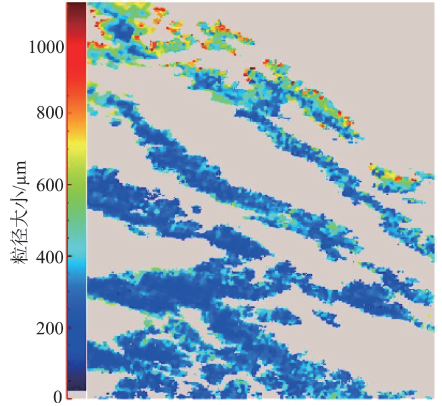
Fig.5 The retrieved snow grain sizes of Zege model for MOD09GA images

图5 Zege 模型反演的MOD09GA影像雪粒径

稀疏混合光谱分析方法通过引入稀疏迭代项,探索解混系数的稀疏特性,被广泛地应用于分类与目标探测之中。然而,这些方法大都基于线性混合模型,假定端元之间是相互独立的。对于非线性的情况,这些算法较难处理。近几年,双线性混合像元分解模型被广泛地研究,大量文献证明双线性相比线性混合模型具有较高的精度。本文引入端元的相互交互进行混合像元分解,即增加了雪、植被、土壤交互项,相当于改动端元矩阵E,将新增加的交互性当作纯净的端元,于是端元矩阵E变为: [snowspec,vegespec,soilspec,shadespec,snowspec×vegespec,snow×soilspec,snowspec×snowspec]。其中,snowspec,vegespec,soilspec,shadespec 分别是雪、植被、土壤、阴影的光谱端元,它们来自于提出的模型中的最优端元获取部分,×符号代表哈达马向量乘积。本文既考虑了最优端元的独立辐射特性,同时包括了最优端元自身的辐射特性,以及它们之间的双线性辐射特性。CLSUnSAL模型包括3个输入参数,分别是最小迭代数目,规则化参数λ,误差容限值,设置3个参数分别为900、0.006、e-4。在运用CLSUnSAL模型解混前,仍然采用类似于MODSCAG模型的方法获取最优雪粒径,此方法本质上是无约束最小二乘最优组合选择,其中均方根误差(RMSE)评价所使用的波段为2-6。在获取各个类的积雪面积后,借鉴Somers的非线性植被面积的估算公式[16],采用式(3)来获取最终的积雪面积。当端元矩阵与MODIS影像没有进行规则化的时候,反演的粒径与积雪面积分别是图6(a)与6(b)。当端元矩阵与MODIS影像同时进行规则化处理后,再进行反演雪粒径与积雪面积,如图7所示。观察Non-CLSUnSAL与Norm-CLSUnSAL模型的结果,发现解混后的二次项系数f12f11大都为0,这有可能是CLSUnSAL模型将所有的二次项稀疏成0了,这可能是由于MODIS影像空间分辨率较小,雪与植被或者自身的非线性交互不明显或者传感器没有探测到。今后应该深入地研究这个现象,包括选择不同时相的积雪MODIS影像、不同高程的积雪分布,以及选择不同的稀疏回归方法。
SFC = f 1 + f 1 f 1 + f 2 + f 3 ( f 12 + f 11 + f 13 ) (3)
式中:SFC为积雪面积;f1为解混获取的积雪单次辐射积雪面积;f2为解混获取的植被单次辐射面积;f3为解混获取的土壤单次辐射面积;f12为积雪与植被交互获取的面积系数; f11为积雪自身交互获取的面积系数;f13为积雪与土壤交互获取的面积系数。
Tab.1 The accuracy statistics of different models for snow cover fraction retrieval

表1 不同模型积雪面积反演的参数统计

模型 RMSE R TSCA
Non-CLSUnSAL 0.2500 0.520 0.7776
Norm-CLSUnSAL 0.1820 0.570 0.9949
MOD10A1 0.1954 0.569 1.0250
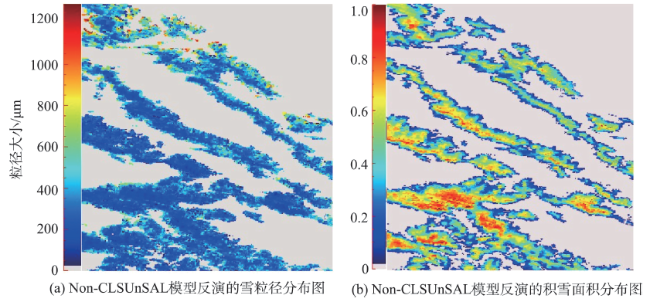
Fig. 6 The unmixing results of Non-CLSUnSAL model

图6 Non-CLSUnSAL 模型混合像元分解

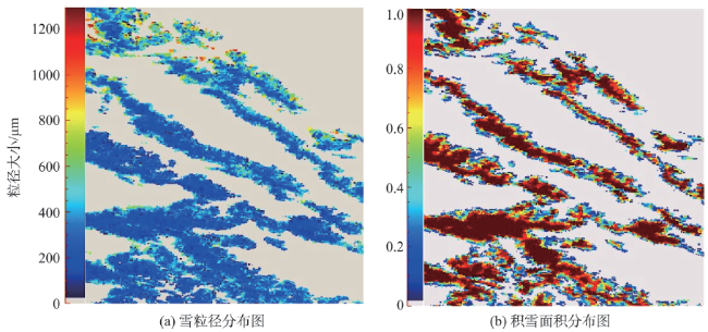
Fig.7 The unmixing results of Norm-CLSUnSAL model

图7 Norm-CLSUnSAL 模型混合像元分解

5 结果与讨论

为了验证各个模型的积雪面积反演精度,本文使用TM影像获取积雪面积,将其作为真值。NDSI方法被用来获取二值积雪面积,阈值被设置成0.33,这里引用参考文献[15],由于此景影像地物较为单一,阈值的选择影响较小。由于TM影像空间分辨率为30 m,而MOD09GA产品的空间分辨率为500 m,因此本文使用了一个大小为17×17的模板重采样TM二值积雪面积,使其与MOD09GA空间分辨率保持一致。一景相应时间的MOD10A1产品被用来评价提出的算法。由于各种解混算法获取的积雪面积为0-1之间,而MOD10A1产品为0-100之间,为了进行验证分析,将MOD10A1产品转换为0-1之间的系数,然后裁剪出研究区域(图8)。
在获取各种解混模型的结果之后,将比较分析各个模型的精度。由于没有实测的雪粒径,故没有评价不同模型的雪粒径反演精度。分析图6、7可知,Non-CLSUnSAL与Norm-CLSUnSAL 2个模型反演的雪粒径大小变化不大,这说明L2范数规则化没有影响雪粒径反演,都是基于MODSCAG模型中的均方根误差最小化。通过比较Zege模型与解混模型对雪粒径反演,发现Zege模型反演的雪粒径值普遍比解混模型大。另外,本文采用了2景2008年此区域Hyperion遥感影像来反演雪粒径,模型分别采用Norm-CLSUnSAL 与Zege模型,再次验证了Norm-CLSUnSAL 反演的雪粒径比Zege小(对于积雪面积大于0.95的像元)。同时,对Zege与Norm-CLSUnSAL模型反演的雪粒径分布作图,如图9所示(其中雪粒径小于80 μm或者大于1000 μm的像元排除在外)。由图9可知,2个模型获取的雪粒径分布都类似与F分布且带着长尾,Zege模型的平均雪粒径明显比Norm-CLSUnSAL模型大,这与上述分析一致。
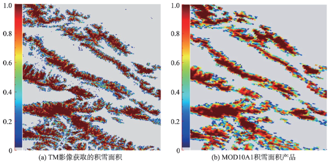
Fig. 8 Two snow cover fraction validation images

图8 2种验证影像

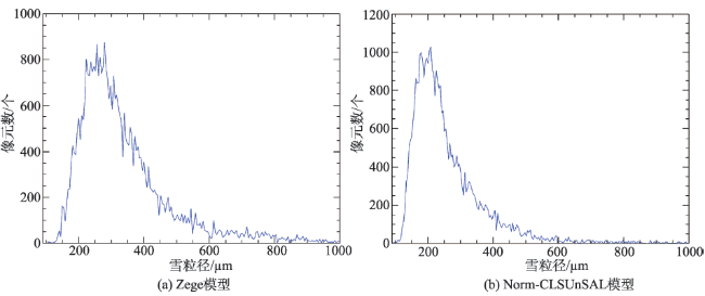
Fig.9 Snow grain sizes distributions of Zege and Norm-CLSUnSAL models

图9 Zege模型与Norm-CLSUnSAL模型反演的雪粒径统计分布

分析完各种模型对雪粒径反演的精度后,分析不同模型对积雪面积反演的精度。本文采用总的积雪面积(TSCA)[17],相关系数(R),均方根误差(RMSE)指标来评价。其中相关系数矩阵被定义为线性皮尔逊相关系数,RMSE仅仅计算各种算法积雪面积大于0.1的像元。我们首先目视分析各种算法的精度,首先Non-CLSUnSAL获取的雪盖面积明显低于TM影像的值,而Norm-CLSUnSAL与TM影像积雪面积非常相近。同时我们统计了各类指标的值,如表1所示。由表1可知,Norm-CLSUnSAL模型反演的积雪面积精度最高。
为了验证模型的鲁棒性,黑河流域同步实验中另外2景同一天获取的MODIS与TM影像[18]来验证模型的精度。经过对比分析,Norm-CLSUnSAL仍然为最高精度,这说明Norm-CLSUnSAL对于积雪面积的反演精度较高。

6 结论与展望

本文针对MODIS遥感影像提出了一种考虑雪粒径变化的积雪面积反演算法,利用高空间分辨率遥感影像对积雪面积进行了验证,证明其具有较高的精度。由于没有实测雪粒径数据,本文选取了此区域2景Hyperion高光谱影像,分别利用Norm-CLSUnSAL与Zege模型获取了雪粒径。通过进行对比分析发现,Norm-CLSUnSAL 反演的雪粒径比Zege小(对于雪盖面积大于0.95的像元)。具体结论如下:
(1)本文提出的解混模型不仅考虑了积雪端元的变化,还考虑了积雪端元与其他端元的二次交互过程,能更有效地刻画积雪的物理过程。
(2)本文提出的解混模型相比MODSCAG模型,具有更高的运行效率。其采用渐进辐射传输模型动态地建立不同粒径大小的雪反射率光谱库,有利于加速程序的运行。
(3)通常情况下,利用辐射传输模型建立的雪反射率光谱库与遥感影像上的积雪光谱不在一个尺度上,会导致光谱完全不匹配。为了减弱光谱之间的不匹配,本文采用了L2范数规则化,从Non-CLSUnSAL与Norm-CLSUnSAL模型获取的积雪面积可知,L2范数规则化具有非常重要的意义。
研究区的MOD09GA产品中,很难找到没有被云覆盖的影像,故本文采用了9月无云的数据。不同季节积雪粒径会发生变化,从而对积雪反射率造成影响,今后将提出的模型应用于研究区冬季的遥感影像,以验证模型的鲁棒性。另外,积雪的有效粒径大小涉及积雪粒径的体积与面积参数,目前很难准确地进行量测,今后会重点发展雪粒径量测的工具。

The authors have declared that no competing interests exist.

[1]
Salomonson V V, Appel I.Development of the Aqua MODIS NDSI Fractional Snow Cover Algorithm and Validation Results[J]. IEEE Transaction on Geoscience and Remote sensing, 2006,44(7):1747-1756.The principal purpose of this paper is to describe the development and validation of an algorithm to estimate the fraction of snow cover within a 500-m pixel of the Moderate Resolution Imaging Spectroradiometer (MODIS) operating on the Earth Observing System Aqua spacecraft. The performance of this algorithm and algorithms applicable to the MODIS on the Terra spacecraft are compared. Validation efforts show that both pixel-level, fractional snow cover relationships for the Terra and Aqua MODIS instruments work well as quantified by such measures as correlation coefficient (r) and root-mean-square error when compared to Landat-7 Enhanced Thematic Mapper ground-truth observations covering a substantial range of snow cover conditions. Over all the scenes used herein, the correlation coefficients were near 0.9 and the RMSE near 0.10. However, somewhat better performance was found for the Terra MODIS versus the Aqua MODIS over nearly concurrently observed scenes. Furthermore, it is clear that more improvements in fractional snow cover estimates within MODIS pixels should be pursued to better account for variability in slope and aspect, atmospheric effects, snow cover types, and land cover

DOI

[2]
Dobreva I D, Klein A G.Fractional snow cover mapping through artificial neural network analysis of MODIS surface reflectance[J]. Remote Sensing of Environment, 2011,115:3355-3366.

[3]
Kokhanovsky A A, Zege E P.Scattering optics of snow[J]. Applied Optics, 2004,43(7):1589-1602.Permanent snow and ice cover great portions of the Arctic and the Antarctic. It appears in winter months in northern parts of America, Asia, and Europe. Therefore snow is an important component of the hydrological cycle. Also, it is a main regulator of the seasonal variation of the planetary albedo. This seasonal change in albedo is determined largely by the snow cover. However, the presence of pollutants and the microstructure of snow (e.g., the size and shape of grains, which depend also on temperature and on the age of the snow) are also of importance in the variation of the snow's spectral albedo. The snow's spectral albedo and its bidirectional reflectance are studied theoretically. The albedo also determines the spectral absorptance of snow, which is of importance, e.g., in studies of the heating regime in snow. We investigate the influence of the nonspherical shape of grains and of close-packed effects on snow's reflectance in the visible and the near-infrared regions of the electromagnetic spectrum. The rate of the spectral transition from highly reflective snow in the visible to almost totally absorbing black snow in the infrared is governed largely by the snow's grain sizes and by the load of pollutants. Therefore both the characteristics of snow and its concentration of impurities can be monitored on a global scale by use of spectrometers and radiometers placed on orbiting satellites.

DOI PMID

[4]
Kokhanovsky A A, Aoki T, Hachikubo A, et al.Reflective properties of natural snow: Approximate asymptotic theory versus in situ measurements[J]. IEEE Transaction on Geoscience and Remote sensing Letters, 2005,43(7):1529-1535.ABSTRACT Results of measurements of the bidirectional reflection function of snow for the solar zenith angle close to 54掳 are compared with a recently developed snow optical model based on the representation of snow grains as fractal particles. The model has a high accuracy out of the principal plane for the observation zenith angles smaller than 60掳. However, the accuracy is reduced in the principal plane. Specular light reflection by partially oriented snow plates on the snow surface not accounted for by the model can play a role for measurements in the principal plane. The model discussed can be used for the grain size retrieval using both ground and spaceborne measurements of the snow reflectance. This is supported by a high accuracy of the model in a broad spectral range 545-2120 nm as demonstrated in this work.

DOI

[5]
Zege E, Katsev I, Malinka A, et al.New algorithm to retrieve the effective snow grain size and pollution amount from satellite data[J]. Annals of Glaciology, 2008,49(1):139-144.This paper presents a new simple and efficient algorithm to retrieve the effective snow grain size and soot concentration from spectral reflectance on snow measured by optical instrument on a satellite. This algorithm was recently developed and will be used for integrated ice–atmosphere–ocean monitoring in the framework of the DAMOCLES program. The algorithm is based on an analytical approach to snow optics. In this approach snow is considered as a close-packed medium with irregularly shaped grains rather than with independent spherical particles. Unlike the known conventional algorithms, the developed algorithm uses no a priori snow optical model. The analytical nature of this algorithm provides a very fast inversion of the reflection data. The developed algorithm was realized and validated for the GLI and MODIS instruments. The algorithm can be generalized for other satellite instruments with appropriate spectral channels. Finally, the results of verifications using a computer simulation are discussed.

DOI

[6]
Kokhanovsky A A, Rozanov V V, Aoki T, et al.Sizing snow grains using backscattered solar light[J].International Journal of Remote Sensing, 2011,32(22):6975-7008.Not Available

DOI

[7]
Zege E, Katsev I, Malinka A, et al.Algorithm for retrieval of the effective snow grain size and pollution amount from satellite measurements[J]. Remote Sensing of Environment, 2011,115(10):2674-2685.ABSTRACT We present an algorithm for retrieval of the effective Snow Grain Size and Pollution amount (SGSP) from satellite measurements. As well as our previous version (Zege et al., 2008, 1998), the new algorithm is based on the analytical solution for snow reflectance within the asymptotic radiative transfer theory. The SGSP algorithm does not use any assumptions on snow grain shape and allows for the snow pack bidirectional reflectance distribution function (BRDF). The algorithm includes a new atmospheric correction procedure that allows for snow BRDF. This SGSP algorithm has been thoroughly validated with computer simulations. Its sensitivity to the atmosphere model has been investigated. It is shown that the inaccuracy of the snow characteristic retrieval due to the uncertainty in the aerosol and molecular atmosphere model is negligible, as compared to that due to the measurement errors at least for aerosol loads typical for polar regions. The significant advantage of the SGSP over conventional algorithms, which use a priori assumptions about particle shape and (or) not allow for the BRDF of the individual snow pack, is that the developed retrieval still works at low sun elevations, which are typical for polar regions.Research highlights78 Retrieval of the Snow Grain Size and Pollution (SGSP) from satellite measurements. 78 No assumptions on snow grain shape. 78 Allows for the snow pack bidirectional reflectance distribution function. 78 New atmospheric correction procedure. 78 Works at low sun elevations, typical for polar regions.

DOI

[8]
Roberts D A, Gardner M, Church R, et al.Mapping chaparral in the Santa Monica Mountains using multiple endmember spectral mixture models[J]. Remote Sensing of Environment, 1998,65(3):267-279.A new technique, called multiple endmember spectral mixture analysis (MESMA), was developed and tested in the Santa Monica Mountains, using Airborne Visible/Infrared Imaging Spectrometer (AVIRIS) data acquired in the fall of 1994 to map California chaparral. The technique models remotely measured spectra as linear combinations of pure spectra, called endmembers, while allowing the types and number of endmembers to vary on a per pixel basis. In this manner, vegetation is characterized by a unique set of endmembers as well as by the fractions. Reference endmembers were selected from a library of field and laboratory measured spectra of leaves, canopies, nonphotosynthetic materials (e.g., stems), and soils and used to develop a series of candidate models. Each candidate model was applied to the image, then, on a per pixel basis, assessed in terms of fractions, root mean squared (RMS) error, and residuals. If a model met all criteria, it was listed as a candidate for that pixel. For this study, selection criteria included fractions between 鈭0.01 and 1.01, an RMS less than 0.025 and a residual less than 0.025 in seven or more contiguous bands. A total of 889 two-endmember models were evaluated and used to generate 276 three-endmember models. To facilitate model selection from a large pool of candidates, an optimal set was selected to provide maximal areal coverage. A total of 24 two-endmember and 12 three-endmember models were chosen. These models were used to generate fraction images and vegetation maps showing evergreen and drought deciduous or senesced vegetation. We found that a majority of the image could be modeled as two-endmember models. Three-endmember models provided greater areal coverage, yet provided poorer vegetation discrimination due to an increase in model overlap (two or more model candidates modeling the same pixel). The vegetation maps demonstrate that the technique is capable of discriminating a large number of spectrally distinct types of vegetation while capturing the mosaic-like spatial distribution typical of chaparral. However, additional research is required to fully evaluate the technique and validate the vegetation maps that were produced.

DOI

[9]
Painter T H, Dozier J, Roberts D A, et al.Retrieval of subpixel snow-covered area and grain size from imaging spectrometer data[J]. Remote Sensing of Environment, 2003,85(1):64-77.Abstract We describe and validate an automated model that retrieves subpixel snow-covered area and effective grain size from Airborne Visible/ Infrared Imaging Spectrometer (AVIRIS) data. The model analyzes multiple endmember spectral mixtures with a spectral library of snow, vegetation, rock, and soil. We derive snow spectral endmembers of varying grain size from a radiative transfer model; spectra for vegetation, rock, and soil were collected in the field and laboratory. For three AVIRIS images of Mammoth Mountain, California that span common snow conditions for winter through spring, we validate the estimates of snow-covered area with fine-resolution aerial photographs and validate the estimates of grain size with stereological analysis of snow samples collected within 2 h of the AVIRIS overpasses. The RMS error for snow-covered area retrieved from AVIRIS for the combined set of three images was 4%. The RMS error for snow grain size retrieved from a 3 脗 3 window of AVIRIS data for the combined set of three images is 48 Am, and the RMS error for reflectance integrated over the solar spectrum and over all hemispherical reflectance angles is 0.018.

DOI

[10]
Painter T H, Rittger K, McKenzie C, et al. Retrieval of subpixel snow covered area, grain sizeand albedo from MODIS[J]. Remote Sensing of Environment, 2009,113(4):868-879.We describe and validate a model that retrieves fractional snow-covered area and the grain size and albedo of that snow from surface reflectance data (product MOD09GA) acquired by NASA's Moderate Resolution Imaging Spectroradiometer (MODIS). The model analyzes the MODIS visible, near infrared, and shortwave infrared bands with multiple endmember spectral mixtures from a library of snow, vegetat...

DOI

[11]
杨针娘,杨志怀,梁凤仙,等.祁连山冰沟流域冻土水文过程[J].冰川冻土,1993,15(2):235-241.

[ Yang Z N, Yang Z H, Liang F X, et al.The study on extraction of snow information of the area Using TM image in Binggou Watershed, Qilian Mountains[J]. Journal of Glaciology and Geocryology, 1993,15(2):235-241. ]

[12]
杨针娘,杨志怀,张学成.祁连山冰沟寒区径流及产流模式[J].中国科学院兰州冰川冻土研究所集刊,1992(7):91-100.

[ Yang Z N, Yang Z H, Zhang X C.Runoff and its generation model of cold region in Binggou basin of Qilian mountain[C].Memoirs of Lanzhou Institute of Glaciology and Geocryology, Chinese Academy of Sciences, 1992,7:91-100. ]

[13]
Gruninger J H, Ratkowski A J, Hoke M L.The Sequential Maximum Angle Convex Cone (SMACC) endmember model[C]. Proceedings SPIE, Algorithms for Multispectral and Hyperspectral and Ultraspectral Imagery, 2004.

[14]
Iordache M D, Bioucas-Dias J, Plaza A.Collaborative sparse regression for hyperspectral unmixing[J]. IEEE Transactions on Geosciences and Remote Sensing, 2014, 52:341-354.Sparse unmixing has been recently introduced in hyperspectral imaging as a framework to characterize mixed pixels. It assumes that the observed image signatures can be expressed in the form of linear combinations of a number of pure spectral signatures known in advance (e.g., spectra collected on the ground by a field spectroradiometer). Unmixing then amounts to finding the optimal subset of signatures in a (potentially very large) spectral library that can best model each mixed pixel in the scene. In this paper, we present a refinement of the sparse unmixing methodology recently introduced which exploits the usual very low number of endmembers present in real images, out of a very large library. Specifically, we adopt the collaborative (also called "multitask" or "simultaneous") sparse regression framework that improves the unmixing results by solving a joint sparse regression problem, where the sparsity is simultaneously imposed to all pixels in the data set. Our experimental results with both synthetic and real hyperspectral data sets show clearly the advantages obtained using the new joint sparse regression strategy, compared with the pixelwise independent approach.

DOI

[15]
郝晓华,王建,李宏毅. MODIS雪盖制图中NDSI阈值的检验——以祁连山中部山区为例[J].冰川冻土,2008,30(1):132-138.NSIDC发布的MODIS全球积雪面积产品采用的NDSI阈值为0.40,但在我国并没有验证,在区域积雪制图中仍然需要进行NDSI阈值选取的试验.选择祁连山中部山区常年积雪区作为研究区,利用SNOMAP方法从Landsat-ETM+影像中提取积雪图.通过与目视解译获取的积雪图作比较,该方法提取积雪面积总体精度超过96%,可将其作为地面真实积雪.然后选用MODIS 1B资料,采用NDSI方法得到研究区积雪图,通过改变NDSI阈值得到不同的MODIS积雪图与假设真实值Land-sat-ETM+积雪图进行对比.比较结果表明:NSIDC发布的MODIS积雪面积产品采用的NDSI阈值0.40偏高,造成研究区积雪面积的低估;通过对3个子研究区积雪图对比及统计分析,得出该区域的合理阈值为0.33.

[ Hao X H, Wang J, Li H Y.Evaluation of the NDSI threshold value in mapping snow cover of MODIS: A Case study of snow in the middle Qilian Mountains[J]. Journal of Glaciology and Geocryology, 2008,30(1):132-138. ]

[16]
Somers B, Asner G P, Coppin P.Nonlinear hyperspectral mixture analysis for tree cover estimatesin orchards[J]. Remote Sensing of Environment, 2009,113(6):1183-1193.Accurate monitoring of spatial and temporal variation in tree cover provides essential information for steering management practices in orchards. In this light, the present study investigates the potential of Hyperspectral Mixture Analysis. Specific focus lies on a thorough study of non-linear mixing effects caused by multiple photon scattering. In a series of experiments the importance of mult...

DOI

[17]
Dobreva I D, Klein A G.Fractional snow cover mapping through artificial neural networkanalysis of MODIS surface reflectance[J]. Remote Sensing of Environment, 2011,115:3355-3366.

[18]
师银芳. 基于TM影像的祁连山冰沟实验区积雪信息提取研究[D].兰州:西北师范大学,2012.

[ Shi Y F.The study on extraction of snow information of the area Using TM image in Binggou Watershed, Qilian Mountains[D].Lanzhou: Northwest Normal University, 2012. ]

Outlines

/