
Journal of Geo-information Science >
An Automatic Method for Creating the Geological Boundary Layer
Received date: 2016-03-15
Request revised date: 2016-07-01
Online published: 2017-03-20
Copyright
It has been generally accepted that the geological boundary feature is essential and fundamental feature in the process of building the spatial database of geologic map. Owing to the largest numbers of graphic elements in geological boundary layer, its digitization and quality inspection become more onerous. The traditional method commonly starts with the drawing of geological boundary layer, then designs the geological body layer by the way of line to arc on the foundation of the geological boundary layer. According to the traditional way, we can learn that geological boundary layer and geological body layer share the same spatial data. It is consistent with the digital geological map database standards of China Geological Survey. When we have the existed geological body layer and the geological boundary layer is missing, the quick method which making the best use of the same spatial data to produce the geological boundary layer will be considered as fully remarkable and reliable. It not only puts forward an automatic method for creating the geological boundary layer, but also automatically tests the attribute data quality of the geological boundary layer. The method is implemented as a three-step process. First of all, the geological body adjacency relation graph is constructed briefly which is aimed at extracting the geological boundary efficiently and accurately based on the geological body layer. Secondly, the recognition rules of stratum contact relationship is summed up, and is applied to recognize the basic stratum contact relationship and the fault contact relationship automatically on the basis of occurrence data and fault data. Finally, according to the situation that the recognition results among the multi-segment boundaries of two adjacent stratums are not unique, principles of the "parallel unconformity first" and the "length first" are given to make a reasonable integrated judgment. This test is based on 1: 50,000 scale of Lushan geological map and created the geological boundary layer automatically. It demonstrated that this method was efficient, fast and accurate. This method has the certain advantages of a faster way to create the geological boundary layer in the process of constructing the geologic map spatial database and at the same time it is an effective tool to inspect the quality of the geological boundary layer.
YAO Mengmeng , LI Anbo , CHEN Ying , WU Chunying . An Automatic Method for Creating the Geological Boundary Layer[J]. Journal of Geo-information Science, 2017 , 19(3) : 326 -335 . DOI: 10.3724/SP.J.1047.2017.00326
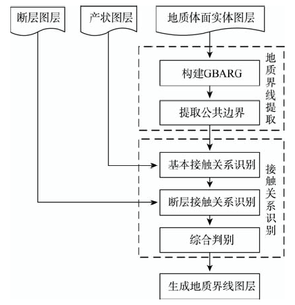
Fig. 1 The flowchart of creating the geological boundary layer图1 地质界线图层制作流程图 |
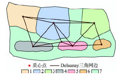
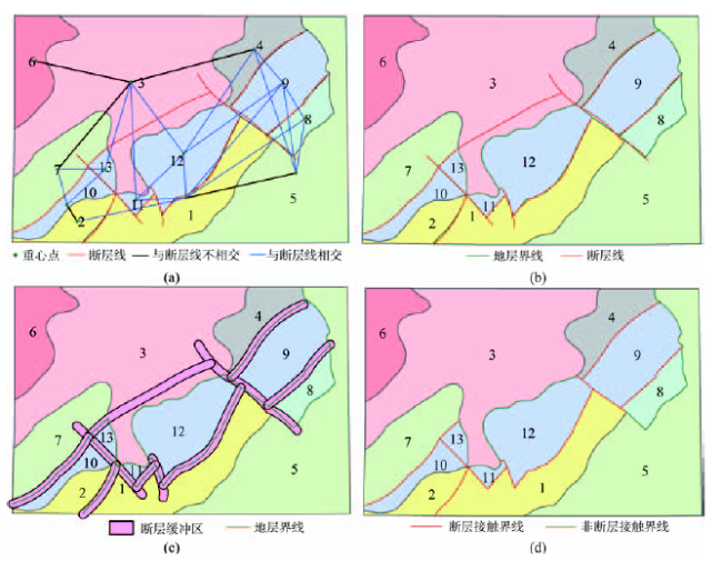
Fig. 2 Delaunay triangulation图2 Delaunay三角剖分 |
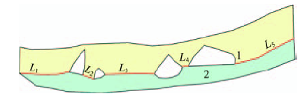
Fig. 3 Schematic drawing of extracting common boundary图3 公共边界示意图 |
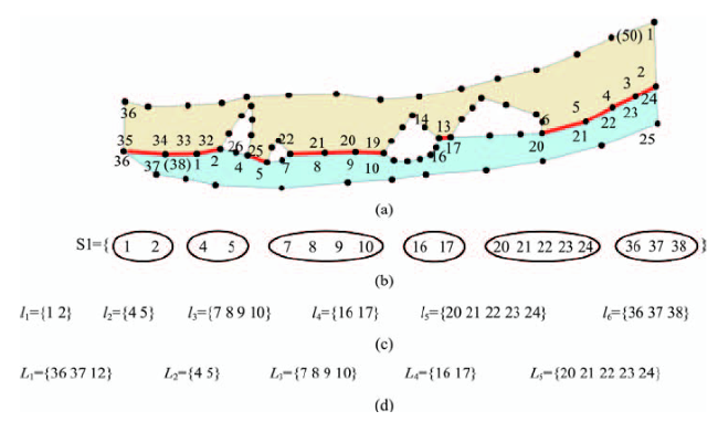
Fig. 4 Extraction of common boundaries图4 公共边界的提取流程 |
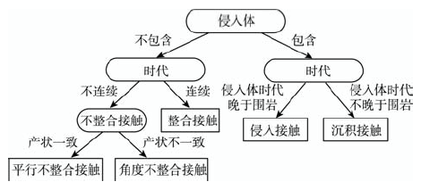
Fig. 5 Decision tree of recognizing contact relationship图5 接触关系识别决策树 |
Tab. 1 Rules of recognizing contact relationship表1 接触关系识别规则 |
| 规则名称 | 自然语言 | 形式语言 |
|---|---|---|
| 接触类型 判别规则 | 若地质体面实体mi 或地质体面实体mj的类型为侵入体,则接触类型为岩体与围岩间接触;否则,接触类型为岩层间接触 | If RockType(mi) ==“侵入体” Or RockType(mj) ==“侵入体” Then ContactType = SurroundContact Else ContactType = StrataContact |
| 时代连续规则 | 若地质体面实体mi的岩石地层单位Rocknamei与地质体面实体mj的岩石地层单位Rocknamej一致或相邻,则形成时代连续;否则,形成时代不连续 | If Rocknamei == Rocknamej Or IsAdjacenct(Rocknamei ,Rocknamej)=true Then IsContinuity (mi,mj) = True Else IsContinuity (mi,mj) = False |
| 产状一致规则 | 若2个地质体面实体mi和mj产状的倾向Dip与走向Strike均相等,且倾角Angle差值小于等于,则产状一致;反之,则不一致 | If Dipi == Dipj And Strikei == Strikej And |Anglei - Anglej |≤(0°<<10°) Then OccurrenceIsSame(mi,mj) = True Else OccurrenceIsSame(mi,mj) = False |
| 侵入体和围岩新老判别规则 | 若地质体面实体(侵入体)mi的岩石地层单位Rocknamei晚于围岩mj的岩石地层单位Rocknamej,则侵入体晚于围岩;否则,侵入体早于围岩 | If IsLate(Rocknamei, Rocknamej)= True Then LateType = Intrusive Else LateType = Surrounding rock |
Fig. 6 Recognition of the fault contact relationship图6 断层接触关系的识别 |
Fig. 7 The example of integrated judgment图7 综合判别示例 |
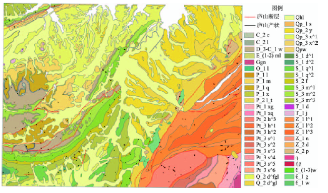
Fig. 8 Experiment data of Lushan图8 庐山实验数据 |
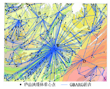
Fig. 9 Map of adjacency relationship of geological body图9 地质体邻接关系图 |
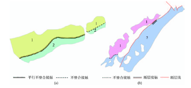
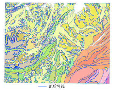
Fig. 10 Geological boundary图10 地质界线 |
Tab. 2 Geological boundary表2 地质界线 |
| 地质界线类型 | 地质界线数/条 |
|---|---|
| 整合接触关系 不整合接触关系 平行不整合接触关系 | 185 705 36 |
| 角度不整合接触关系 尚未细分的不整合接触关系 | 6 663 |
| 断层接触关系 | 29 |
| 侵入接触关系 | 4 |
| 沉积接触关系 | 3 |
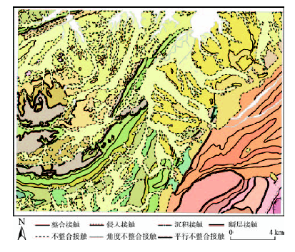
Fig. 11 Thematic map of Lushan geological boundary图11 庐山地质界线专题图 |
Tab. 3 Integrated judgment表3 综合判别 |
| 界线两侧地层名称 | 识别结果组合 | 综合结果 | 综合原则 |
|---|---|---|---|
| 新港粘土下段、茅山组中段 | 断层接触、不整合接触 | 不整合接触 | 长度原则 |
| 茅山组中段、茅山组上段 | 断层接触、整合接触 | 整合接触 | 长度原则 |
| 观音堂组、大姑泥砾 | 角度不整合接触、不整合接触 | 角度不整合接触 | 平行不整合优先原则 |
| 皮园村组、大姑泥砾 | 角度不整合接触、不整合接触 | 角度不整合接触 | 平行不整合优先原则 |
| 大姑泥砾、莲沱组下段 | 断层接触、不整合接触 | 不整合接触 | 长度原则 |
| 新港粘土下段、清水组上段 | 平行不整合接触、不整合接触 | 平行不整合接触 | 平行不整合优先原则 |
The authors have declared that no competing interests exist.
| [1] |
中国地质调查局.DD2006-06,数字地质图空间数据库标准[S]. 2006:1-17.
[
|
| [2] |
[
|
| [3] |
[
|
| [4] |
[
|
| [5] |
[
|
| [6] |
[
|
| [7] |
[
|
| [8] |
|
| [9] |
|
| [10] |
[
|
| [11] |
|
| [12] |
|
| [13] |
[
|
| [14] |
[
|
| [15] |
[
|
| [16] |
[
|
| [17] |
[
|
| [18] |
[
|
| [19] |
[
|
| [20] |
[
|
| [21] |
[
|
| [22] |
[
|
| [23] |
[
|
| [24] |
[
|
| [25] |
庐山幅地质图说明书[M].南昌:江西地质矿产勘查开发局,1993:1-17.
[Geological Introduction of Lushan Area[M]. Nanchang: Jiangxi Bureau of Geology and Mineral Resources, 1993:1-17. ]
|
| [26] |
[
|
/
| 〈 |
|
〉 |