Orginal Article

Spectral Analysis of Road Pavements and Monitoring of the Aging Conditions of Asphalt Pavement from Worldview-2 Imagery

  • JIN Xu , 1 ,
  • ZHANG Xian feng , 1, * ,
  • LUO Lun 2 ,
  • PAN Yifan 1 ,
  • YANG Ke 2
Expand
  • 1. Institute of Remote Sensing and GIS, Peking University, Beijing, 100871, China
  • 2. China Transport Telecommunications & Information Center, Beijing 100011, China
*Corresponding author: ZHANG Xianfeng, E-mail:

Received date: 2016-08-30

  Request revised date: 2017-02-28

  Online published: 2017-05-20

Copyright

《地球信息科学学报》编辑部 所有

Abstract

The rapid development of highway transport networks has increased much work load to road maintenance departments in China, and consequently it is currently a pressing demand to develop new technical support to rapidly and accurately collect the health conditions of road pavements. In contrast to the conventional methods, previous research indicated that remote sensing might offer a new approach for the monitoring of pavement conditions of highway roads. This paper first tends to examine the spectral responses and features of the road pavements with different aging conditions and pavement materials based on field measurements of the pavement spectral reflectance. In addition, this study also tries to construct effective road pavement condition index from satellite remote sensing data for the monitoring of pavement health conditions. One of the findings shows that the slope of the spectral curves in the wavelength region of 400~900 nm grows bigger from negative to positive with the gradual aging of the asphalt pavements based on the field measurements of the pavement spectra. After that, several spectral index models were built up to monitor and evaluate the road pavement aging conditions by means of simple arithmetical calculation such as ratio and normalization. To demonstrate the applicability of the proposed indices to satellite remotely sensed data, a Worldview-2 image acquired on September 21, 2013 in the Liangxiang area near the sixth Ring Road south, Beijing City was used to analyze the road pavement health conditions, and to verify these models using the Munsell Scale Card values that were collected together with the spectral measurements and used to indicate the pavement aging conditions in our study. The image was first preprocessed in RSI ENVI software package, such as radiometric and geometric corrections, and subset. The four proposed indices were calculated from the Worldview-2 image in the study area and evaluated using the in-situ measurements of the pavement health conditions by visually comparing the performance of the proposed spectral indices in characterizing the asphalt pavement aging conditions. Furthermore, correlation analysis between spectral pavement condition indices and the Munsell Scale Card values shows that the logarithmic health index can achieve the biggest determinant coefficient (R2=0.72,n=23) and may be applicable in the monitoring of road pavement conditions. The case study indicates that road pavements with different materials and aging conditions have distinct spectral response in visible and near-infrared wavelength, and satellite remote sensing can be employed in the rapid mapping and assessment of large-range asphalt road pavement conditions. Thus, the study extends remote sensing applications and offers a new technique for the road maintenance departments. Future work may explore spectral mixture analysis in asphalt condition mapping from low-altitude unmanned aviation vehicle (UAV) hyperspectral imagery.

Cite this article

JIN Xu , ZHANG Xian feng , LUO Lun , PAN Yifan , YANG Ke . Spectral Analysis of Road Pavements and Monitoring of the Aging Conditions of Asphalt Pavement from Worldview-2 Imagery[J]. Journal of Geo-information Science, 2017 , 19(5) : 672 -681 . DOI: 10.3724/SP.J.1047.2017.00672

1 引言

作为交通运输的纽带,公路在国家发展和经济建设中起到了不可忽视的作用,中国公路建设在近20年发展迅猛,到2015年年末,全国公路总里程457.73万km,公路密度47.68 km/100km2 [1]。随着公路建设的长远发展,路面养护和健康检测变得越来越重要。目前中国公路路面健康状况面临严峻的考验:路面检修周期长,车辆超速超载,自然灾害加重路面腐蚀等。因此,保障路面健康状况的高效监测已成为一项重要任务[2]。目前比较成熟的公路路面检测方法主要有:弯沉测定、平整度测定、抗滑性能测定和车辙测定[3],这些方法往往需要实地测量,存在效率低、费用高等难以避免的缺陷[4]
发达国家从20世纪末开始就在交通领域大力发展遥感技术应用。2000年,美国交通部与美国航空航天局NASA联合组建了美国国家交通遥感协会(National Consortium on Remote Sensing in Transportation,NCRST),对交通设施管理和道路交通环境、交通流与交通灾害监测等方面开展了研究。将遥感技术与地面实测相结合,有效解决了路面变化检测、交通辅助决策系统的建立等问题[5]。目前,采用遥感技术监测道路路面健康状况的研究尚处于起步阶段,现有的技术途径主要包括:①基于高空间分辨率遥感影像的图像识别法,利用影像空间分辨率较高的特征,借助像元之间相关性帮助分析路面对象特征;②基于高光谱遥感的路面反射率或比辐射率特征建模法,此方法通过分析路面反射率或比辐射率特征来建立模型以监测路面的老化状况和病害;③利用LiDAR构建路面精细三维模型来定量化提取路面病害和路面平整度信息。已有研究表明:高光谱遥感在城市地物识别、植物与农作物精细监测[6]、矿物勘察领域得到了广泛应用。此外,该技术在交通领域也有很好的应用前景[7-8],如公路交通中道路的材质识别、路面状况的监测等[9]。根据不同材质路面,如水泥、沥青路面的不同光谱特征,以及不同使用年限路面的光谱差异,可对路面状况进行监测[10]。另外,部分研究者结合路面实地光谱测量,基于MIVIS、AVIRIS等机载高光谱影像对高光谱遥感在路面状况调查的应用进行了初步研究,发现路面光谱特征随着路面状况的改变存在相应的变化[11]。但是由于AVIRIS空间分辨率较低,城市道路错综复杂,容易被汽车、周围的建筑物、树木等设施遮挡,光谱异质性复杂,路面健康状况的监测结果存在较大误差[12-13]。Herold等基于更高空间分辨率(0.5 m)的HyperSpecTIR高光谱数据,利用所建立的光谱模型对路面健康状况进行了评估,获得了较为可靠的结果,但依然存在路面材质差异导致健康状况评估不准确的问题[14-15]
综上所述,当前道路遥感健康检测还处在理论和初步试验阶段,路面状况遥感监测的机理尚不清楚,且没有形成成熟的道路提取方式、变化检测模型和有效的健康检测指数;遥感在交通领域的应用深度和广度均不足。本文通过遥感手段建立中国公路路面老化状况监测体系,包括研究中国不同材质路面,主要是沥青路面的光谱反射特征,并据此建立适合监测沥青路面老化状况的光谱指数;选择获得性好的高空间分辨率遥感数据开展实验研究,验证遥感技术在沥青路面健康状况监测中的适用性,为中国道路养护部门提供新的技术途径。

2 沥青路面光谱特征分析

2.1 研究区概况

研究区位于北京市房山区,由六环路西段和南段以及长虹西路、黄良路和东环路包围而成,面积约30 km2。研究区公路道路总体上平整,裂缝、龟裂、波浪拥包等现象并不多见,老化程度也不严重;但部分道路路面碎石颗粒明显,虽然路面平整,但公路表面存在细小缝隙,影响公路质量;部分辅路路面未能及时养护,老化现象相对于主路更严重。图1为地面测量地点的分布情况。经过实地考察,最终参考当地路况选择7处测量点,主要测量不同年龄的路面光谱和不同病害的路面光谱。
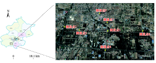
Fig. 1 The locations of the in-situ spectral measurements in the south of Beijing

图1 地面实测数据采集点

2.2 地面光谱测量与数据收集

为了便于分析这些老化路面的光谱变化特征,本文依据《公路沥青混凝土路面养护技术规范》 中规定的路面老化种类,将所建立的道路路面综合光谱库分解为以下3类情况来进行测量:①选取正常路面不同车道采样点;②选取几种不同材质路面的采样点;③选取不同老化状况下的路面采样点。
公路路面病害光谱数据采集采用美国光谱分析仪器公司(Analytical Spectral Devices,ASD)生产的FieldSpec ProFR便携式地物光谱辐射测量仪,其光谱仪的测量范围为350~2500 nm [16],光谱分辨率最高可达1 nm。测量条件符合光谱测量的环境要求[17]。路面灰度采集采用Munsell明度精选色卡-全光泽(Munsell Neutral Value Scale-Glossy Collection),本色卡选择37个灰色等级[18],颜色明度0.5/-9.5,间距为四分之一递增,每个色系标有蒙赛尔色号和相干红外能量光源C的反射系数百分比,有全光泽(37色)或半光泽(31色)供选择[19]。本实验采用目测方式进行灰度等级评定。同时,获取了2013年9月21日的Worldview-2多光谱数据,利用ENVI/FLAASH进行了大气辐射校正,并利用获取的GPS控制点进行几何精校正,误差在1个像元内。
本实验最终获取光谱数据89条,光谱数据类型及数量如表1所示。
Tab. 1 Number and types of spectroscopic data of the road pavements

表1 路面光谱数据获取类别及数量

路面类型 光谱数据数量
沥青路面 老化初期 32
老化中期 9
老化后期 18
病害路面 14
老化初期与后期交界 1
水泥路面 5
土壤路面 4
沥青路面白色油漆标线 2
路边植被 4

2.3 不同材质路面的光谱特征分析

从地面实测获得路面光谱数据中,选择具有代表性的样本,进行不同材质路面的光谱特征比较分析。图2显示了不同类型路面的光谱特征。
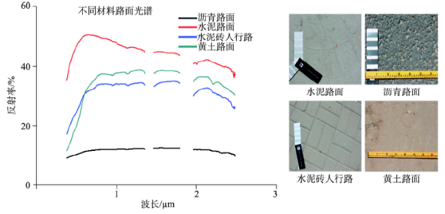
Fig. 2 Spectral curves of various types of road pavements

图2 不同材料路面的光谱反射曲线

选择路面较新且没有病害的路段,按老化初期水泥路面、老化初期沥青路面、水泥砖人行路和较为平整的黄土路面进行比较。从反射率来看,老化初期沥青路面沥青含量高,反射率最低;水泥路面光滑,反射率最高。人行路主要由水泥构成,光谱特征曲线与水泥路面相似,但由于表面粗糙,因而反射率比水泥路面略低。平整的黄土路由于表面平整,总体反射率较高。从光谱特征波段来看,老化初期沥青路面的光谱曲线总体较平稳,在400~700 nm区间反射率有轻微上升,然后趋于稳定,在2000 nm过后有少许下降。水泥路面在400~700 nm处有比较快的反射率上升,从700 nm开始下降且下降趋势越来越缓,但在2100~2200 nm处反射率有轻微上升。人行道路面与水泥路面光谱曲线总体相似,除了反射率偏低之外,在400~700 nm区间反射率上升趋势没有水泥路面明显,在700~2000 nm处反射率变化很小,但在2100~2200 nm处的反射率上升比水泥路面更突出。黄土路面的光谱曲线与人行道相似,不过在400~700 nm处的反射率上升趋势明显,在2100~2200 nm处同样有反射率的升高,但是在2200~2300 nm处有轻微吸收特征。总的看来,沥青路面的反射率较水泥路面、黄土路面、水泥人行道都低得多,所以较易将其与其他材质路面区别开来。

2.4 不同老化程度的沥青路面光谱特征

沥青路面的光谱特征并不是一成不变的,随着时间的推移,路面沥青组分的物理化学反应与载荷磨损等都会导致沥青路表面成分的改变,进而影响路面的光谱特征。
沥青路面在经历轮胎磨损、车辆重压、雨雪腐蚀及空气氧化等一系列人为和自然作用后往往会出现路面磨损、沥青挥发、石料裸露等老化现象,更严重者会出现麻面、裂缝、拥包等病害情况,给车辆的行驶带来不便[20]图3是经过地面观测总结的沥青路面老化的一般规律:挥发、氧化反应等现象造成沥青损耗,荷载磨损加速石料裸露,在这些现象的持续作用下,路面矿物颗粒裸露变细,除沥青外的粘合剂等成分脱落,最终出现路面病害现象。
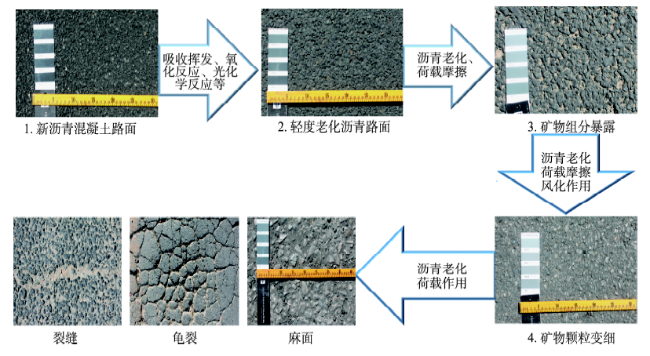
Fig. 3 The aging processes of the road pavement

图3 沥青路面老化过程

路面老化受多种因素影响,中国的沥青一般由饱和酚、芳香酚、胶质和沥青质4种物质组成[21],氧化、挥发、硬化是沥青路面老化的主要情况[22]。氧化主要为太阳光中的紫外线等影响沥青中的氧化反应,碳氢、碳碳之间化学键断裂生成羰基酸等分子[23-24],氧化过程中也会发生脱氢缩合作用,生成高分子化合物[25];昼夜温差变化造成的路面热胀冷缩会使路面易发生裂缝、拥包等病害;此外,雨水腐蚀带来的化学变化,车辆磨损带来的物理变化也会导致路面老化[26]
沥青路面老化往往遵循相似的规律,沥青路面由于车辆磨损以及沥青挥发、氧化等因素,路面沥青含量降低,岩石颗粒裸露,导致路面粗糙,一方面沥青的减少提高了光谱反射率,另一方面裸露出的岩石光谱特性会影响整个路面的光谱特征。随着磨损风化的加剧,路面的石子在车辆磨损中变得光滑,沥青含量进一步减少,车辆带来的长期压力也在逐渐破坏路面结构,使路面变得松散,在温度变化和风化作用下,路面整体凹凸不平,产生麻面现象。麻面进一步加剧,石料裸露磨损,路表面凹凸不平、张力改变,而沥青的减少导致路面粘性减少、弹性增加,在这种情况下,在反复经历高温膨胀和低温收缩后路面发生不同程度的断裂[27],故最终出现路面开裂,造成横裂、纵裂、龟裂等现象,也可能导致凹陷、拥包等路面病害。
把不同年龄的沥青路面光谱曲线进行比较,可更好地研究沥青路面老化时的光谱变化。图4为 9种不同沥青路面的光谱特征,从样本的光谱曲线可以发现:随着沥青路面的老化,路面反射率总体上升。新路面光谱曲线在400~2100 nm总体呈现上升趋势,路面老化越严重上升趋势越缓,旧路面反射率会在400~900 nm处有大幅度的上升,再缓慢下降;随着沥青路面的老化,2300 nm处的吸收特征变得不明显。
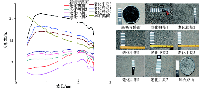
Fig. 4 Spectral characteristics for different aging conditions of road pavements

图4 不同老化程度路面的光谱曲线

沥青路面光谱变化主要是道路老化过程中路面化学成分的变化导致的,路面磨损会增加岩石骨料的裸露程度,使得路面光谱特征受石料本身特性的影响;热作用会导致路面成分挥发,从而改变路面材料的成分比例;而氧化和紫外线则会带来一系列化学反应,改变沥青材料的分子结构[28],而分子结构是物质光谱特性的重要体现。因此,虽然沥青路面的光谱特征都是在2100 nm前呈增长趋势,沥青中碳氢化合物的羟基引起的1750 nm处的吸收峰依旧随着沥青减少、石料增加而逐渐减小[29]
综上所述,沥青路面的光谱特征受沥青与石料的含量配比、沥青路面的物理特性等多种因素影响,其老化的光谱特征规律如下:①在400~900 nm处,随着沥青路面逐渐老化,反射率曲线的斜率由负变正,逐渐增大;②900~2000 nm处随着路面老化反射率逐渐减小,斜率的绝对值增大;③2300 nm处的吸收特征随着路面老化逐渐减弱。不同类型的路面病害也会影响沥青路面的光谱特征,如图5所示,路面裂缝会导致光谱反射率在1000 nm处骤降,裂缝越深,吸收越大,且不受裂缝走向的影响。路面车辙会导致900~1000 nm处的强吸收,这是因为裂缝和车辙会影响路面的平整度,光线进入缝隙中被不停反射和吸收,导致路面吸收增强。沥青路面其他现象,比如标线、阴影、沙土、洒水等同样会影响路面光谱反射率,比如标线会提高路面反射率,带水路面在可见光波段对路面的反射率明显降低。因此,根据沥青路面老化及病害的光谱特征,寻找区分这些光谱曲线的特征谱段,可构建适宜路面健康检测的光谱指数。
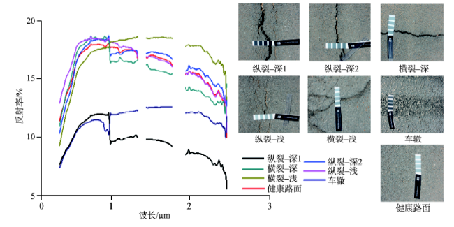
Fig. 5 Spectral characteristics for cracks and tracks of the road pavements

图5 沥青路面的裂缝、车辙病害光谱特征

3 沥青路面健康光谱指数的构建与验证

3.1 沥青路面健康光谱指数的构建

除了因为老化导致的沥青路面反射光谱差异外,还有很多其他因素也影响路面反射率。如雨后路面潮湿的情况下,道路反射率会下降;路面建筑阴影下的路面反射率也会降低,沥青路岩料与沥青配比不同,也会影响沥青路面反射率的值,因此依靠反射率的高低来判断路面老化情况并不一定有效。从沥青道路光谱特征曲线上可发现新旧路面有2处明显差异:在400~900 nm和2100~2300 nm波长区间。在400~900 nm处,路面反射率都有上升,但明显可见路面老化越严重,反射率上升就越快,且不受反射率值的影响,可更好地体现路面老化特征。在2100~2300 nm处沥青路面反射率存在一个峰值,这一情况随着路面的老化而变得越来越不明显,因此可从这一特性上判断路面的老化程度。此外,在900~2100 nm波长区间,随着路面老化,道路反射率的斜率逐渐减小,最终由正值变为负值,这也很好地体现了路面老化的光谱特征变化规律[30-31]
针对沥青路面光谱曲线的上述特征,结合Worldview-2的8个波段的波长覆盖范围,选定400~900 nm波段范围中更能体现斜率变化的Worldview-2蓝色波段(450~510 nm)和近红外波段(770~895 nm)作为研究沥青路面老化指数的参数,来构建能反映沥青路面健康状况的光谱指数模型。
(1)差值健康指数(Difference health index, DHI): DHI是基于近红外波段与蓝光波段的反射率之差来构建的路面健康光谱指数,类似差值植被指数。
(2)比值健康指数(Ratio health index, RHI): RHI是基于近红外波段与蓝光波段的反射率之比来构建的路面健康光谱指数,类似比值植被指数。
(3)归一化差值健康指数(Normalized difference health index, NDHI): NDHI是参照归一化植被指数构建的反映沥青路面老化状况的健康指数。
NDVI = ρ 7 - ρ 2 ρ 7 + ρ 2 (1)
式中:ρ2和ρ7分别为Worldview-2光谱数据第2波段和第7波段反射率,输出结果为NDHI路面健康指数。
(4)对数健康指数(Logarithmic health index, LHI): 路面越新,近红外波段与蓝光波段的反射率差距越小;路面越老,他们的差距越大。因此,以取对数的形式对2个波段的差值进行处理,放大老化初期差值较小时的光谱特征。
LHI = lo g 2 ( ρ 7 - ρ 2 ) (2)
式中:ρ2和ρ7分别为Worldview-2光谱数据第2波段和第7波段反射率值,输出结果为基于取对数方法的路面健康指数LHI。
本研究选用实验区2013年的Worldview-2数据。首先对Worldview-2数据进行辐射定标、大气校正、图像融合图像剪裁获取道路目标后,得到研究区的道路光谱情况[32-33]。根据上述4种路面健康指数,运用实验区的Worldview-2数据进行沥青路面老化状况的遥感监测实验,其中部分结果见图6
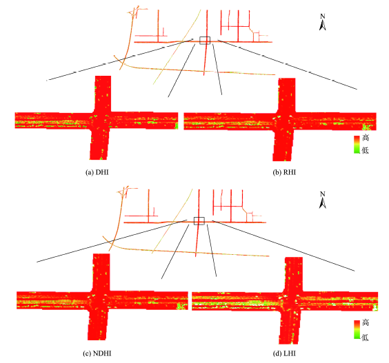
Fig. 6 Spectral health indices of the road pavement in 2013 in the study area

图6 2013年实验区沥青路面健康指数

由上述实验可知,所建立的4种光谱指数都能不同程度地体现路面老化情况,但它们又存在差异,通过与地面实地测量结果对比分析,四个指数中对数健康指数(LHI)能更好地筛选出不同老化程度的路面。为了更好地检验对数健康指数(LHI)的路面效果,选择另一处路面(良官公路部分路段),把路面实测获取数据与对数健康指数结果进行对比,结果如图7所示。由式(2)和图4可知,LHI值越大,路面老化越严重。已知该路下行(往南)车道为旧路(图7右侧上方照片),上行(往北)车道有翻新(图7右侧下方照片),因此上行车道显得更新,路面健康状况更好。
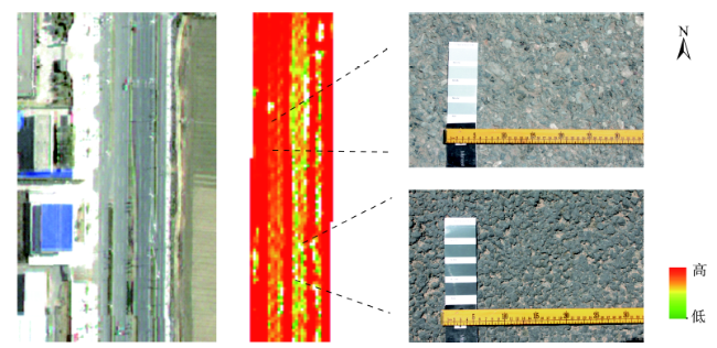
Fig. 7 Visual check of the LHI-based mapping of road pavement

图7 基于LHI的路面健康指数结果验证

3.2 不同指数的比较与验证

将健康指数与路面实测得到的健康状况表征指数进行线性回归,若二者相关性高,则说明该指数能较好地反映路面老化状况。由于沥青路面老化会在可见光波段发生反射率的变化,从肉眼上表现为路面颜色逐渐变浅的特点,因此,将在实验区获取蒙赛尔色数据来代表实地测量的路面健康信息。将每个地面光谱与色卡测量样方的GPS坐标与Worldview-2影像的地理坐标对应,可得到测量样方的遥感健康指数数据。将统一拉升到0-255区间的4个健康指数的值分别与对应像元的色卡值进行统计回归分析。
经过回归分析可得图8结果(数据在5%水平上显著),4种健康指数与色卡读数的回归分析的相关系数(R2)分别为:0.58、0.44、0.55、0.72,表明LHI指数反映的沥青路面老化检测结果与实际测量结果吻合,DHI与NDHI和色卡读数的相关系数相差不大,也具有较高的相关性,DHI最差。因此,LHI能较好利用高空间分辨率的多光谱数据中的近红外和蓝光波段进行沥青路面老化快速检测。
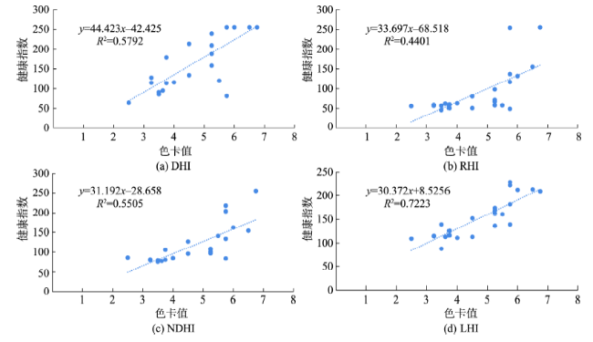
Fig. 8 Regression analysis between the pavement health indices and in-situ measurements

图8 路面健康指数与色卡号值的回归法分析

4 结论

本文从地面光谱测量与Worldview-2卫星影像2个尺度,对不同材质的路面光谱信息进行了对比研究,详细分析了沥青路面不同老化程度和不同病害路面的光谱特征,提出了基于遥感的沥青路面健康状况评价的光谱指数,并以北京市南六环良乡地区的公路路面健康状况研究为实例进行了实证研究,主要结论如下:
(1)不同材质的路面光谱特征差异明显,水泥路面、黄土路面与沥青路面的光谱反射率不同。受路面材质和道路表面物理特征的影响,水泥和土路材质颗粒微小,道路表面更光滑,因此其反射率明显高于沥青路面。
(2)沥青老化路面的光谱特征存在如下规律:越旧的路面,在400~900 nm范围反射率变化值越大;在900~2100 nm处路面由新变旧,反射率的斜率也由大到小、由正到负;在2100~2300 nm波长范围处出现反射峰值,当路面逐渐老化,其峰值会越来越不明显。
(3)沥青路面受沥青和石料双重影响,路面粗糙,反射率总体偏低。车辆行驶的磨损、氧化和沥青挥发导致的路面化学成分改变、热胀冷缩及雨雪腐蚀等天气因素导致的路面物理结构改变,会逐渐导致沥青路面光谱特征发生显著变化。病害路面(如裂缝)会因为缝隙对太阳辐射的吸收导致1000 nm处光谱反射率急剧下降。
(4)实例研究表明:对数健康指数、归一化健康指数、差值健康指数都能较好地利用近红外与蓝光波段对沥青路面老化状况进行监测,其中对数健康指数效果最好,可用于高空间分辨率的卫星多光谱数据实现对道路路面健康状况的遥感检测。
当然,很多客观条件也会对沥青路面的光谱特征产生影响,比如不同气候下沥青老化进程不同,潮湿的气候下沥青路面存在老化加速。雨天后路面潮湿,水的吸收会使沥青路面反射率下降;路边的行道树阴影尤其是路面较窄的路段也会对沥青路面的光谱产生影响。此外,行人和车辆会遮挡路面,因此需要选择合适的时间获取光谱信息。由于对路面老化的研究还存在一定的局限性,今后需要进一步探索基于亚像元光谱分解策略构建沥青路面健康状况遥感监测算法,以解决非路面地物与路面混合像元的影响。

The authors have declared that no competing interests exist.

[1]
中国交通运输部. 2015年交通运输行业发展统计公报[R].2015.

[Ministry of Transport of the People’s Republic of China. 2015 Statistical bulletin of transportation industry development[R]. 2015. ]

[2]
王春清. 京秦高速公路沥青路面预防性养护技术研究[D].西安:长安大学,2007.

[Wang C Q.Study on the preventive maintenance of asphalt pavement of Beijing-qinhuangdao highway[D]. Xi′an: Chang′an University, 2007. ]

[3]
胡群芳. 公路路面结构使用性能评价与预测研究[D].郑州:郑州大学,2003.

[Hu Q F.The study of evaluation and forecast on pavement structure performance[D]. Zhengzhou: Zhengzhou University, 2003. ]

[4]
郭峰超. 宁夏沥青路面养护对策研究[D].西安:长安大学,2014.

[Guo F C.Research on the maintenance strategies of asphalt pavement for Ningxia[D]. Xi′an: Chang'an University, 2014. ]

[5]
Zhang Q and Couloigner I. A framework for road change detection and map updating[J]. International Archives of the Photogrammetry, Remote Sensing and Spatial Information Sciences, 2004,35:720-734.

[6]
廖春华,张显峰,刘羽.基于多端元光谱分解的干旱区植被覆盖度遥感反演[J].应用生态学报,2012,23(12):3243-3249.lt;p>植被覆盖度是评价陆地生态系统状况与土地荒漠化程度的重要指标.利用环境一号(HJ-1)小卫星上搭载的新型高光谱传感器HSI获取的数据,通过纯净像元指数和端元平均均方根误差相结合的方法提取合适的端元光谱,然后基于多端元混合像元分解(MESMA)模型,反演了新疆石河子地区的植被覆盖度(FVC).通过与线性光谱分解(LSMA)模型反演结果以及地面样方数据进行比较,对HJ1/HSI数据反演结果进行精度评价与光谱验证.结果表明: MESMA模型能对不同的像元选取不同端元组合,更接近实际情况,比LSMA模型能更好地提取植被覆盖度信息;与LSMA模型相比,MESMA模型反演的FVC值与地面实测数据的相关系数从0.766提高到0.838,均方根误差从0.375减少到0.196.</p>

[Liao C H,Zhang X F,Liu Y.Remote sensing retrieval of vegetation coverage in arid areas based on multiple endmember spectral unmixing[J]. Chinese Journal of Applied Ecology, 2012,23(12):3243-3249. ]

[7]
Weng Q.Remote sensing of impervious surfaces in the urban areas: Requirements, methods, and trends[J]. Remote Sensing of Environment,2012,117:34-49.The knowledge of impervious surfaces, especially the magnitude, location, geometry, spatial pattern of impervious surfaces and the perviousness mperviousness ratio, is significant to a range of issues and themes in environmental science central to global environmental change and human nvironment interactions. Impervious surface data is important for urban planning and environmental and resources management. Therefore, remote sensing of impervious surfaces in the urban areas has recently attracted unprecedented attention. In this paper, various digital remote sensing approaches to extract and estimate impervious surfaces will be examined. Discussions will focus on the mapping requirements of urban impervious surfaces. In particular, the impacts of spatial, geometric, spectral, and temporal resolutions on the estimation and mapping will be addressed, so will be the selection of an appropriate estimation method based on remotely sensed data characteristics. This literature review suggests that major approaches over the past decade include pixel-based (image classification, regression, etc .), sub-pixel based (linear spectral unmixing, imperviousness as the complement of vegetation fraction etc .), object-oriented algorithms, and artificial neural networks. Techniques, such as data/image fusion, expert systems, and contextual classification methods, have also been explored. The majority of research efforts have been made for mapping urban landscapes at various scales and on the spatial resolution requirements of such mapping. In contrast, there is less interest in spectral and geometric properties of impervious surfaces. More researches are also needed to better understand temporal resolution, change and evolution of impervious surfaces over time, and temporal requirements for urban mapping. It is suggested that the models, methods, and image analysis algorithms in urban remote sensing have been largely developed for the imagery of medium resolution (10 100 m). The advent of high spatial resolution satellite images, spaceborne hyperspectral images, and LiDAR data is stimulating new research idea, and is driving the future research trends with new models and algorithms.

DOI

[8]
Mohammadi M.Road classification and condition determination using hyperspectral imagery[J]. Unpublished Master thesis, University of Applied Sciences Stuttgart, Germany, 2011.Hyperspectral data has remarkable capabilities for automatic identification and mapping of urban surface materials because of its high spectral resolution. It includes a wealth of information which facilitates an understanding of the ground material properties. For identification of road surface materials, information about their relation to hyperspectral sensor measurements is needed. In this study an approach for classification of road surface materials using hyperspectral data is developed. The condition of the road surface materials, in particular asphalt is also investigated. Hyperspectral data with 4m spatial resolution of the city of Ludwigsburg, Germany consisting of 125 bands (wavelength range of 0.4542 m to 2.4846 m) is used. Different supervised classification methods such as spectral angle mapper are applied based on a spectral library established from field measurements and in-situ inspection. It is observed that using the spectral angle mapper approach with regions of interest is helpful for road surface material identification. Additionally, spectral features are tested using their spectral functions in order to achieve better classification results. Spectral functions such as mean and standard deviation are suitable for discriminating asphalt, concrete and gravel. Different asphalt conditions (good, intermediate and bad) are distinguished using the spectral functions such as mean and image ratio. The mean function gives reliable results. Automatisierte Liegenschaftskarte (ALK) vector data for roads is integrated in order to confine the analysis to roads. Reliable reference spectra are useful in evaluation of classification results for spectrally similar road surface materials. The classification results are assessed using orthophotos and field visits information.

DOI

[9]
Themistocleous K, Neocleous K, Pilakoutas K, et al.Damage assessment using advanced non-intrusive inspection methods: integration of space, UAV, GPR, and field spectroscopy[A].2014.

[10]
Mei A, Fiore N, Salvatori R, et al.Spectroradiometric laboratory measures on asphalt concrete: Preliminary results[J]. Procedia-Social and Behavioral Sciences, 2012,53:514-523.This paper presents the preliminary results of a project concerning the use of spectroradiometric measurements for the characterization of aggregates and asphalts mixtures commonly used for road paving. Radiometrical measurements, in the wavelength range between 350-2500nm, were performed on selected samples with different compositional characteristics; the relationships between spectral signatures and different bituminous mixtures samples were analyzed. The results suggest that spectroradiometrics analyses can be used to establish new efficient and fast road classification procedures to support activities of pavement management systems and interpretation of remote sensed images.

DOI

[11]
Manzo C, Mei A, Salvatori R, et al.Spectral modelling used to identify the aggregates index of asphalted surfaces and sensitivity analysis[J]. Construction and Building Materials, 2014,61:147-155.

[12]
Roberts D A, Herold M.Imaging Spectrometry of urban matarials[C]. King P, Ramsay M S, Swayze G. Infrared spectroscopy in geochemistry, exploration and remote sensing. Ontario: Mineral Associator of Canada, 2004,33:155-181.

[13]
Ban-Weiss G A, Woods J, Levinson R. Using remote sensing to quantify albedo of roofs in seven California cities, Part 1: Methods[J]. Solar Energy, 2015,115:777-790.Cool roofs reflect sunlight and therefore can reduce cooling energy use in buildings. Further, since roofs typically cover about 20–25% of a city, widespread deployment of cool roofs could mitigate the urban heat island effect and partially counter urban temperature increases associated with global scale climate change. The magnitude of these potential benefits for a given city depends on the increase in albedo that can be achieved using reflective roofs. Assessing this increase requires knowledge of roof albedo at the city scale, which until now has been hindered by a lack of reflectance data with sufficient spatial coverage, spatial resolution, and spectral detail. In this work we use multiband aerial imagery to derive the albedos of individual roofs in seven California cities: Los Angeles, Long Beach, San Diego, Bakersfield, Sacramento, San Francisco, and San Jose. The radiometrically calibrated, remotely sensed imagery has high spatial resolution (102m) and four narrowband reflectances: blue, green, red, and near-infrared. First, we locate roof pixels within GIS building outlines. Next, we use laboratory measurements of the solar spectral reflectances of 190 roofing products to empirically relate broadband solar reflectance to reflectances in the four narrow bands; this empirical relationship well predicts solar reflectance, as indicated by a low root-mean-square of the residuals of 0.016. Albedos computed from remotely sensed reflectances are calibrated to ground measurements of roof albedo in each city. The error (accuracy) at 90% confidence interval of the calibrated albedos is found to vary by city, from 0.00–0.01 at low albedo and 0.06–0.14 at high albedo.

DOI

[14]
Herold M, Gardner M E, Roberts D A.Spectral resolution requirements for mapping urban areas[J]. Geoscience and Remote Sensing, IEEE Transactions on, 2003,41(9):1907-1919.

[15]
Herold M, Roberts D, Smadi O, et al.Road condition mapping with hyperspectral remote sensing[A].2004.

[16]
张海波,李峰.ASD地物光谱仪测量技术及使用方法[J].山东气象,2014(1):46-48.

[Zhang H B, Li F.Measuring techniques and methods of application of ASD Field Spec Handheld[J]. Journal of Shandong Meteorology, 2014,1:46-48. ]

[17]
张照录. 地物光谱反射率野外测量实验方案改进[J].测绘科学,2010(5):176-177,175.针对现有地物光谱反射率野外测量实验方案的不足,提出了地物光谱反射率的各向异性测量、不同环境条件的对比测量、不同时相的对比测量以及地物光谱反射率图像模拟四项实验改进方案.利用ISI921VF-128野外地物光谱辐射计和ArcGIS、ERDAS软件进行了实例测量与验证,揭示了真实地物光谱反射率的特征,模拟生成了"图谱合一"的地物光谱反射率图像,提高了实验教学质量.

[Zhang Z L.Temporal-spatial analysis of vegetation on change based on MODIS images[J]. Science of surveying and mapping, 2010,5:176-177,175. ]

[18]
曹连平,王力民,李锡军,等.色差仪的应用实践[J].印染,2004(24):33-38.

[Cao L P, Wang L M, Li X J, et al.Practice on color difference instrument[J]. Printing and dyeing, 2004,24:33-38. ]

[19]

[20]
魏翰超. 基于强度理论的沥青混合料水稳定性评价指标的研究[D].哈尔滨:哈尔滨工业大学,2010.

[Wei H C.Research on index of asphalt mixture water stability testing based on the strength theory[D]. Harbin: Harbin Institute of Technology, 2010. ]

[21]
魏荣梅. 道路沥青的老化与再生研究[D].武汉:武汉理工大学,2006.

[Wei R M.Study on the aging behavior and mechanism of paving asphalt[D]. Wuhan University of Technology, 2006. ]

[22]
赵志军,陈明宇,吴少鹏,等.沥青的老化机理与性能研究[J].建材世界,2009(2):159-162.

[Zhao Z J, Chen M Y, Wu S P, et al.Research on ageing mechanics and performance of asphalt[J]. The World of Building Materials, 2009,2:159-162. ]

[23]
田晓. 石油沥青老化/硬化机理研究[D].北京:中国石油大学,2009.

[Tian X.Study on Ageing/Hardening Mechanism of Petroleum Asphalt[D]. Beijing: China University of Petroleum, 2009. ]

[24]
魏荣梅,余剑英,吴少鹏,等.紫外光老化对沥青化学族组成和物理性能的影响[J].石油沥青,2006(1):6-10.

[Wei R M, Yu J Y, Wu S P, et al.Influence of UV-light on chemical component and physical properties of bitumen[J]. Petuoleum Asphalt, 2006,1:6-10. ]

[25]
赵慧敏. 热再生沥青的路用性能评价[D].大连:大连理工大学,2008.

[Zhao H M.Evaluation of the pavement performance of the hot recycled asphalt[D]. Dalian: Dalian University of Technology, 2008. ]

[26]
涂娟,袁军,包传平.废橡胶粉对SBS改性沥青的老化性能影响研究[J].武汉工程大学学报,2009(3):19-22.在SBS改性沥青中加入糠醛抽出油溶胀后的活化废橡胶粉制备SBS/胶粉复配改性沥青,并对其热老化前后的软化点、针入度、延度等性能进行测试,表明在SBS改性沥青中加入胶粉并不影响改性沥青的热老化性能,而且对改性沥青的耐热老化性能还有一定程度的提高.对几组复合改性沥青的紫外线老化试验也表明加入废橡胶粉能够提高改性沥青的抗紫外老化性能.

DOI

[Tu J, Yuan J, Bao C P.Research of crumb rubber on aging properties of SBS modified asphalt[J]. Journal of Wuhan Institute: Technology. 2009,3:19-22. ]

[27]
栗培龙. 道路沥青老化行为与机理研究[D].西安:长安大学,2007.

[Li P L.Study on the aging behavior and mechanism of paving asphalt[D]. Xi′an: Chang′an University,2007. ]

[28]
纪小平. 路面沥青老化的非线性模拟及再生研究[D]. 西安:长安大学,2008.

[Ji X P.Nonlinear simulation of asphalt aging and recycling strategy study[D]. Xi′an: Chang′an University, 2008. ]

[29]
刘烨. 超光谱遥感路面状况检测的应用研究[D].成都:西南交通大学,2008.

[Liu Y.Road condition mapping with hyperspectral remote sensing[D]. Chengdu: Southwest Jiaotong University,2008. ]

[30]
Herold M, Roberts D.Spectral characteristics of asphalt road aging and deterioration: implications for remote-sensing applications[J]. Applied Optics, 2005,44(20):4327-4334.We integrate ground spectrometry, imaging spectrometry, and in situ pavement condition surveys for assessment of asphalt road infrastructure. There is strong spectral evidence for asphalt aging and deterioration. Several spectral measures derived from field and image spectra correlate well with pavement quality indicators (e.g., a pavement condition index). However, the potential for mapping is limited by fine spatial resolution requirements (as fine as 0.5 m) and by the spectral confusion between pavement material aging and asphalt mix erosion on the one hand and structural road damages (e.g., cracking) on the other.

DOI PMID

[31]
Herold M, Schiefer S, Hostert P, et al.Applying imaging spectrometry in urban areas[M]. Urban remote sensing, 2006:137-161.

[32]
童庆禧,张兵,郑兰芬.高光谱遥感─原理、技术与应用[M].北京:高等教育出版社,2006:129-165.

[Tong Q X, Zhang B, Zheng L F.Hyperspectral remote sensing—principles, techniques, and applications[M]. Higher education press, 2006:129-165. ]

[33]
袁金国,牛铮,王锡平. 基于FLAASH的Hyperion高光谱影像大气校正[J].光谱学与光谱分析,2009(5):1181-1185.

[Yuan J G, Niu Z, Wang X P.Atmosphere correction of Hyperion hyperspectral image based on FLAASH[J]. Spectroscopy and spectral analysis, 2009,5:1181-1185. ]

Outlines

/