Orginal Article

A Fuzzy Matching Model of Spatial-temporal Information of Dispersed Person

  • ZHOU Wenjuan , 1 ,
  • ZHANG Mingfeng , 1, 2, 3, * ,
  • LIN Guangfa 1, 2, 3
Expand
  • 1. Institute of Geography, Fujian Normal University, Fuzhou 350007, China
  • 2. Fujian Provincial Engineering Research Center for Monitoring and Assessing Terrestrial Disasters, Fuzhou 350007, China
  • 3. Research Center for National Geographical Condition Monitoring and Emergency Support in the Economic Zone on the West Side of the Taiwan Strait, Fuzhou 350007, China
*Corresponding author: ZHANG Mingfeng,E-mail:

Received date: 2016-08-30

  Request revised date: 2017-02-28

  Online published: 2017-07-10

Copyright

《地球信息科学学报》编辑部 所有

Abstract

In recent years, a large number of lost persons have aroused the attention of all sectors of society because the collection and query of information is not easy. The network tracing platform is fast in information acquisition and has widely used in the application. However, the information management of lost persons are scattered, and it is insufficient in the spatial and temporal category analysis. To solve the problems of the inaccuracy and ambiguity of information, we made the memory fuzziness analysis of different age groups of lost persons based on the query of their attribute information. Then, combining with the partition of Chinese language and the fuzzy range of space and time, we set threshold and weight for matching algorithm. Finally, we set up the fuzzy matching model for spatial-temporal information of lost persons. Considering several characteristics of the lost people information such as names, gender, blood types, date of birth, missing time, missing place, dialect accent and missing age, we computed the information matching index among the lost persons. In addition, we used the time geography method to design the time correction method of the model and we also verified the intersection of spatiotemporal reachable range of matching results. The results of case verification indicated that the model can consider the known items of matching index and select the information that has higher matching degree.

Cite this article

ZHOU Wenjuan , ZHANG Mingfeng , LIN Guangfa . A Fuzzy Matching Model of Spatial-temporal Information of Dispersed Person[J]. Journal of Geo-information Science, 2017 , 19(7) : 886 -894 . DOI: 10.3724/SP.J.1047.2017.00886

1 引言

根据国家统计局的统计数据,近10年公安机关立案的拐卖妇女儿童刑事案件约十万余起,仅2013年和2014年就高达37 218起[1]。虽然打拐DNA信息数据库正在建立和完善,但匹配需求DNA信息范围广,导致采集成本过高[2]。近年来,图像识别技术日益发展,许多学者对失散人员照片进行匹配分析,如陈飞等基于人脸识别算法建立失散人员照片匹配系统[3];刘持标等基于Android图像识别技术建立失踪人员管理系统[4]。在国外,Eden等对灾难中幸存的不能提供准确信息的儿童,建立了属性及图像匹配系统[5];Wan利用人类视觉系统算法创建年龄化复合草图以帮助搜索失散人员[6]。上述研究中多数失散人员提供的照片往往是失踪多年之后拍摄的,其样貌的变化和拍照技术的更新对匹配成功率具有较大影响。
随着互联网的普及和媒体的重视,相继出现了“宝贝回家”、“随手拍”公益微博、“等着我”国家公益等热心力量[7]。这些网络寻亲平台信息采集快,应用普及范围也较广,如“等着我”节目在2014年开播一年内就收集了十万多条寻人信息,在一定程度上解决了失散人员信息采集的问题。但是这些网络寻亲信息的管理分散,仅使用了传统数据库对数据进行单属性的信息查询,缺乏结合时间范畴和空间范畴的分析,需要大量志愿者来记录和分析。同时,多数失散人员提供的并不是准确的时间,也不是具有确切边界的空间范围。模糊时空范围查询是一种针对具有模糊特性时空信息的查询方式[8]。学者们基于时空模糊查询思想做了许多研究,如陈逸菲针对不确定移动对象,提出了带有截集概念的模糊时空范围[6];柏禄一等对模糊时空数据间的拓扑关系进行研究[9-10];侯志伟等提出包含时间点、时间段、时间位置和时间距离的时间本体概念[11];MacEachren等将GIS应用于个体时空数据集的可视化和时空分析[12];Bigolin等以模糊空间对象和时空对象从面向对象空间数据库中选择和挖掘信 息[13-14]。上述模糊时空的研究只针对某个时间或空间信息研究其时空差异大小,并没有考虑时间和空间信息之间的影响。时间地理学基于空间的平面坐标XY分布,加入了时间T进行分析,构成一个立体的时空框架[15-16],将时空约束用于确定活动双方的时空交集[17],时间地理学工具包括时空路径和时空棱镜等[18]。但传统的时间地理学模型主要考虑短时间内单个主体在限定时间的移动范围,很少应用于两个模糊时空范围的长时序移动过程中的相似匹配研究。
本文在失散人员属性信息查询的基础上,针对失散信息的不完善和模糊性,设计了失散人员时空信息模糊匹配度模型。该模型利用GIS特有的时空分析能力,结合汉语言分区[19]以及模糊时空范围,从基本属性、时空信息、方言信息3个方面设计匹配指标项,并设置模糊时空范围阈值和权重,对匹配度进行计算和排序。最后本文还利用时间地理学设计了模型时空修正方法,对其时空可达范围是否存在交集进行了检验。

2 数据源及研究方法

2.1 数据源

本文各项指标及统计数据来源于“宝贝回家寻子网”的现有登记数据(1995-2015年)、中国社会科学院出版的《中国语言地图集》中的中国汉语方言图以及全国县级行政区划的矢量地图。其中,失踪地点的行政区划来源于县级行政区划矢量地图,方言口音的三级方言分区参考“中国汉语方言图”。

2.2 研究方法

本文在GIS时空分析、汉语方言分区和模糊层次分析法的研究基础上,结合失踪年龄和模糊时空范围查询方法,提出失散人员信息时空模糊匹配度模型的基本思路(图1)。首先,建立失散人员属性信息数据库,分“寻家方”和“寻子方”2个数据库存储,寻家方为失踪孩子,寻子方为丢失孩子的家人,均含有姓名、性别、血型、出生时间、失踪时间、失踪地点、方言等信息;其次,提取失散人员失踪及出生时间,计算失踪年龄,针对不同年龄段提供信息的准确度,结合时间、地点和汉语方言区等信息的特征,利用层次分析法计算各匹配指标项的权重,并设置模糊度阈值和权重,生成模糊匹配度计算模型;然后,将另一数据库中的信息按性别进行过滤,通过计算模型得出匹配度结果,并排序;最后,运用改进的时空棱镜和时空路径工具,对计算模型得到的匹配结果进行修正。
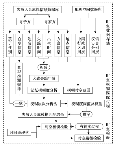
Fig. 1 Flow chart of spatial-temporal fuzzy matching degree model for the information of lost people

图 1 失散人员信息时空模糊匹配度模型流程图

3 失散人员时空模糊匹配模型

3.1 时空模糊匹配指标及含义

失散人员时空信息模糊匹配指标主要分为基本属性、时空信息、方言信息3个方面。基本属性包括姓名、性别和血型;时空信息包括出生时间、失踪时间和失踪地点;方言信息为方言口音。
3.1.1 时空信息
现有模糊时空范围查询的研究,大多以2个不确定对象之间的可能性呈反距离权重均匀分布为分析前提[18]。针对失散人员时空数据具有模糊度的特性,对于模糊的时间或空间概念,都给定模糊距离集合D,根据不同的阈值设置不同的概率e。时间模糊范围由匹配方出生或失踪时间以及时间模糊距离阈值(即时间二级指标)共同决定,按不同的阈值分为若干个不同时间域,分配不同的相似概率。同理,空间模糊范围由匹配方地点以及空间模糊距离阈值共同决定,适用于失踪地点和方言口音。由于失散人员对地点的记忆与行政区划等关系密切,因此匹配方地点可以是准确的坐标位置,也可以是一个区域,如行政区划或汉语方言分区。对应的空间模糊距离阈值可以是两点之间的欧几里得距离,也可以是行政区或汉语方言区的条件外延范围。空间模糊距离阈值按匹配方地点的精确程度分别分为3个级别,条件外延范围即表1中失踪地点和方言口音对应的二级指标。
Tab. 1 The weight of indicators in different age groups

表1 不同年龄段各指标权重表

匹配指标项 0~2岁 2~4岁 4~10岁 10岁以上
孩子姓名 0.04 0.04 0.05 0.20
出生时间 0.22 0.11 0.10 0.21
失踪时间 0.22 0.14 0.19 0.16
出生/失踪地点 0.06 0.11 0.15 0.18
方言口音 0.05 0.13 0.18 0.10
血型 0.41 0.47 0.33 0.15
一致性检验 0.027 0.041 0.019 0.022
3.1.2 方言信息
汉语方言分区一直颇受众多学者关注,一般根据语音标准和词汇语法特点,分成色彩鲜明的、界限大体清晰的方言区[19-22]。方言信息是一个容易被忽略的关键指标,其独立于人的记忆,具有明显的地域性。对于年龄较小或记忆信息模糊的失踪者,口音在一定程度上还可以辅助判断其出生地点。
虽然汉语方言分区依据口音和用词可以细化到县级单位[23-24],但多数失散人员的口音往往很难被判别出来。因此,根据失散人员方言信息界限判断不准确的特性,选择分类较为明确、易于判断的七大方言区作为失散人员的二级汉语方言区,包括北方方言、吴方言、湘方言、粤方言、闽方言、客家方言及赣方言[25]。向上设置较模糊的一级汉语方言区,包括北方方言和南方方言两类[22,26],用于口音区分不明显的失散人员。针对方言判别准确的失散人员,向下设置区分较为精细的三级汉语方言区,包括北方方言中的晋语和八区官话以及南方方言中的吴语、徽语、闽语、赣语、湘语、粤语、客家话、平话[22]。最后,将三级汉语方言分区转化为3个方言分布图层(图2),存入失散人员地理空间数据库。
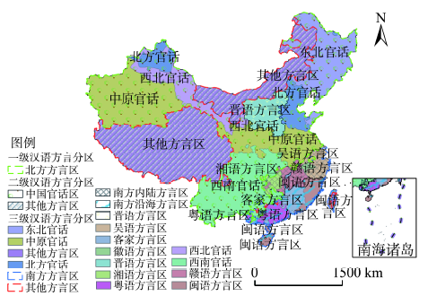
Fig. 2 Location distribution of Chinese dialects

图2 汉语方言区位置分布图(根据“中国汉语方言图”修改)

3.2 时空模糊匹配指标权重

失踪年龄对记忆的准确程度影响较大,首先应进行年龄记忆模糊度分析。据统计,失散人员的失踪年龄主要集中在刚出生的婴儿、3~7岁的幼儿和13~17岁的青少年。唐卫海等对儿童记忆监测的实验结果显示,4岁开始具有基本的回溯能力,10岁之后维持在较高水平[27],而2岁之前对孩子的年龄误判差距较小。因此,可以将失散人员按年龄分为0~2岁、2~4岁、4~10岁和10岁以上4个阶段。根据各年龄段的孩子记忆特征,利用模糊层次分析法计算不同年龄段的指标权重R表1)。
经过总结大量报道案例以及到管理部门调研等工作,根据失散人员的记忆特征及其时空误差规律,构建了中国失散人员时空信息模糊匹配指标模型;并利用专家打分法确定了具体匹配指标项、二级指标和权重W表2)。
Tab. 2 Indicators and weight of fuzzy matching indicators for spatiotemporal information

表2 时空信息模糊匹配指标项及权重表

匹配指标项 二级指标(权重)
孩子性别 一致(1) 不一致(0)
孩子姓名 完全相同(1) 含有相同字(0.7) 完全不相同(0.5)
血型信息 完全匹配(1) 可能匹配(0.8) 完全不匹配(0.1)
出生时间 当年(1) 前后一年(0.8) 前后三年(0.6) 前后五年(0.2)
失踪时间 前后三个月(1) 前后六个月(0.8) 前后两年(0.6) 前后五年(0.1)
失踪地点
(三选一)
精确到省级 该省界内部(1) 国内邻接省(0.4)
精确到市级 该市区内部(1) 该省内邻接县(0.5) 同省其他地区(0.3)
精确到县级 该县镇内部(1) 该县镇所在市(0.7) 同省非本市区(0.2)
方言口音
(三选一)
精确到一级方言 第一级匹配(1) 完全不匹配(0.5)
精确到二级方言 第二级匹配(1) 仅第一级匹配(0.5) 完全不匹配(0.2)
精确到三级方言 第三级匹配(1) 第一、二级匹配(0.7) 仅第一级匹配(0.3) 完全不匹配(0)

3.3 匹配度指数计算

模型设置“寻家方”和“寻子方”两个信息数据库,包含上述匹配体系中的7个匹配指标项。信息匹配总会由其中一方发起,本文将发起匹配一方称为失散匹配方。首先,由失散匹配方的失踪时间和出生时间计算失踪时的年龄,从表1中选取对应年龄段各匹配指标的权重Ri。再按照性别一致的要求,对另一方数据库中的数据进行筛选,并利用式(1)计算筛选结果的其它6个指标的匹配值。由于失散人员所能提供的信息量不同,为了不影响匹配度计算结果的正确性,允许只选取已知的n项信息参与匹配度指标公式计算过程。其计算公式为:
e = i = 1 n R i W ij / i = 1 n R i ( n 6 1 k 4 (1)
式中:e为失散人员信息匹配度;Ri为已知的第i种匹配指标项在对应年龄段下的权重;Wij为第i种匹配指标对应的第j个二级指标的权重;n为参与匹配度指数计算的匹配指标个数。
失散人员信息匹配度是一个概率性概念,取值范围为[0,1],其计算结果是比较性的数据值,不存在一个确切的范围和标准。由于数据准确性误差的存在,本体系保留所有可能的匹配情况,并认为匹配度大于0.5时信息匹配的概率较大,在模型中优先排序考虑。在全国失散人员信息大数据中,匹配度指标作为失散人员信息相似度的参考指标,其值对挖掘关键、有效的信息数据有重要的指导意义。其不仅能衡量2条信息之间的相似程度,还可以在多数据间形成明显的横向比较,通过相似度从大到小排序的方式返回失散人员信息内容,方便用户在大量数据中进行查询检索。

4 基于时间地理学的模型修正方法

4.1 匹配度模型存在的问题

失散人员信息时空模糊匹配度计算模型虽然可以很好地计算筛选出较符合的信息,但依然存在信息时空错位的问题。对存在多次贩卖经历或失散过程地点变化的失踪者,若失踪地点相同,但失踪时间相差较大,匹配的可能性依然很小;若其失踪时间相近,但失踪地点相距较远,匹配的可能性也较小。

4.2 基于时间地理学的模型修正方法

时间地理学认为时间变量和空间变量同等重要[28],其主要包括时空路径和时空棱镜2个最核心的工具[27]。其中,时空路径详尽地记录了个体活动的时空属性,由控制点和路径段落构成[29-30],其时空范围是时段[t1,t2]内经过的空间范围[x1,y1,x2,y2 ]所构成的时空立方体 [14]。而针对具有多次贩卖经历或失散过程地点存在变化的失踪者,时空路径可以将时间作为第三轴,立体地描述其失踪过程的时空范围,通过时空距离进行匹配,如图3右边的示意图所示。
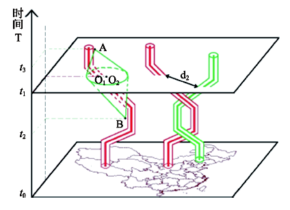
Fig. 3 The method of path correction(left: single space-time prism, right: space-time path)

图3 路径修正方法(左:单时空棱镜,右:时空路径)

根据失散人员提供的时间和地点,计算每一个时刻ti所对应的误差距离di,累加各个时间的误差距离并进行标准化,以衡量失散过程存在交集的可能性大小。其计算公式为:
D = i = 0 n d i / T (2)
式中:D为时空路径模糊总误差距离;diti时刻下两个位置的距离差;T为计算过程的总时间长度。
传统的时空棱镜是由前后2个反向圆锥组成的交集[31],其边界是个体所能到达的最大时空范 围[32]。改进的时空棱镜思想利用2个相交的时空棱镜,利用圆锥边界表达失散人员提供的失踪地点Bi与现在所在位置Ai之间,由于记忆模糊等因素影响下有可能匹配的最大范围。失散时空棱镜检验可适用于双方都只有失散地点的情况(图3),也适用于一方具有路径而另一方只有失散地点的情况(图4)。计算两个时空棱镜重合的体积与失散匹配方的总体积之比,或失散路径重合的长度与失散匹配方的总长度之比,即为失散人员间的地点时间重合度C
Fig. 4 Prism correction method of double space-time

图4 双时空棱镜修正方法

根据匹配度大小筛选出较为相似的失散人员,利用时间地理学模型修正方法进行修正。修正过程按是否存在失散路径分为2种情况,失散路径指失散过程中双方都到达过2个以上不同地点。若存在失散路径,利用式(2)计算其时空路径模糊总误差距离D,认为D应低于1000 km,小于500 km优先考虑;若不存在失散路径,选择时空棱镜修正方法,认为时间地点重合度C必须大于零,大于50%应优先考虑。

5 计算案例与结果讨论

5.1 计算案例及分析

根据上述算法对某个成功案例的匹配度进行分析和计算。以寻子方寻找失踪男孩黄*龙为例,其出生时间为1976年3月,失踪时间为1982年6月,失踪地点精确到市级为福建三明市,方言口音精确到三级方言属于闽语。寻家方男孩黄*涛,名字含有相同字,指标阈值权重为0.7;认为自己的出生时间为1976年12月,误差范围在一年以内,指标阈值权重为1;失踪时间为1983年4月,误差范围在前后两年以内,指标阈值权重为0.6;失踪地点为福建省龙岩市连城县,属于福建省内三明市邻接县,指标阈值权重为0.5;方言口音属于南方方言,仅第一级方言匹配,指标阈值权重为0.3。这个孩子的失踪年龄段为4~10岁,选取表1中4~10岁年龄段的指标权重,由于血型信息缺失不参与计算,共有5项信息参与匹配度指标公式计算,信息匹配度指数为0.564(表3)。
Tab. 3 Matching index analysis of the cases

表3 案例各匹配指标项分析表

匹配指标项 寻子方 寻家方 指标阈值权重 失踪年龄 指标权重
孩子姓名 黄*龙 黄*涛 0.7 4~10岁 0.05
出生时间 1976年3月 1976年12月 1.0 0.10
失踪时间 1982年6月 1983年4月 0.6 0.19
失踪地点 福建省三明市 福建省龙岩市连城县 0.5 0.15
方言口音 闽语 南方方言 0.3 0.18
以该失散匹配方信息根据匹配度计算模型计算的部分结果如表4所示。其中,案例2的出生和失踪时间与失散匹配方吻合,但由于失踪地点和方言口音差异,其匹配度低于案例1;案例3由于缺失失踪地点数据,其对应权重为该匹配项除不匹配外的最低匹配值的一半,即为同省其他地区(0.3)的一半;虽然其方言口音与失散匹配方接近,但出由于出生和失踪时间的偏差,导致其匹配度也低于案例1;案例4由于各项匹配指标项相似度都不高,其综合匹配度较低;案例5各个匹配指标项都较匹配,但性别不同使其匹配度为零。该结果说明失散人员信息时空模糊匹配度计算模型能综合考虑失散匹配方已知的匹配指标项,剔除一些相似度不高的案例,将综合相似程度较好的数据显示出来,也保留了部分匹配指标项相似度高的案例。
Tab. 4 Calculation table of matching degree for lost people information

表4 失散人员案例信息匹配度计算表

匹配指标项 性别 孩子姓名 出生时间 失踪时间 失踪地点 方言口音 匹配度
失散匹配方 黄*龙 1976年3月 1982年6月 福建省三明市 闽语
指标权重 1.00 0.05 0.10 0.19 0.15 0.18
案例1 黄*涛 1976年12月 1983年4月 福建省连城县 南方方言 0.56
1.00 0.70 1.00 0.60 0.50 0.30
案例2 林*阳 1976年5月 1982年9月 广东省东莞市 粤语 0.55
1.00 0.50 1.00 1.00 0.00 0.30
案例3 朱*楠 1979年8月 1986年1月 缺失数据 闽方言 0.51
1.00 0.50 0.20 0.10 0.15 0.70
案例4 张*原 1974年7月 1985年2月 福建省漳州市 南方方言 0.30
1.00 0.50 0.60 0.10 0.30 0.30
案例5 吴*媛 1976年2月 1982年7月 福建省福州市 闽方言 0.00
0.00 0.50 1.00 1.00 1.00 1.00

5.2 时空匹配项分析

在该验算案例中,匹配方是发起寻找的寻子方黄*龙,以其出生时间和失踪时间为基准,时间模糊范围在4~10岁年龄段的时间模糊距离阈值及对应的相似概率如图5所示。
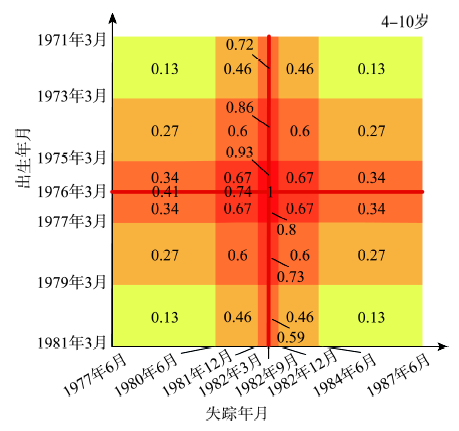
Fig. 5 Threshold and weight of the fuzzy distance of the time of the cases

图5 案例时间模糊距离阈值及权重

本案例中的匹配方地点包括寻子方黄*龙的失踪地点和方言口音。失踪地为福建三明市,精确到市区,因此,其空间模糊距离阈值为三明市内部、福建省内三明市的邻接县和福建省省非三明市区域,对应的权重为1、0.5和0.3。同理设置闽语、闽方言区和南方方言的三级方言口音模糊距离阈值,其对应的权重为1、0.7和0.3。行政区和汉语方言区及其对应的外延区在空间上叠加后,乘以4~10岁年龄段的失踪地点匹配指标项的权重后,将可能匹配区域分为图6中的7个等级。
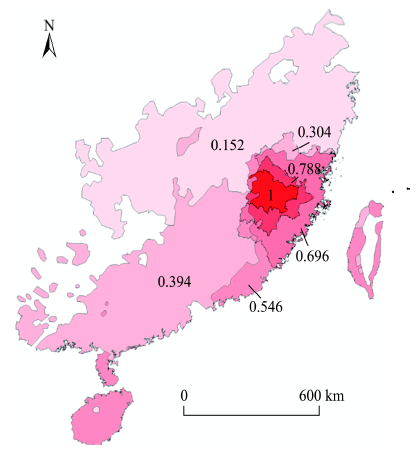
Fig. 6 Map of weight distribution and the fuzzy spatial extent

图6 模糊空间范围及权重分布图

6 失踪人员信息匹配原型系统设计

6.1 数据库设计及实现平台

本系统将AIR技术与GIS相结合,基于Flex(Adobe Flash Builder 4.6)开发平台,选择SuperMap iServer 7C为GIS云服务器,利用SuperMap iClient 7C for Flash进行系统开发。“捡·爱”宝贝回家信息匹配系统是以中国行政区划数据为依托,分别建立了中国失散人员属性信息数据库和地理空间数据库。其中,中国失散人员属性信息数据库包括用户数据表、孩子寻家方信息搜索表及索引、父母寻子方信息搜索表及索引、父母寻子方详细信息表和管理员信息表;地理空间数据库包括中国行政区划分级地图、中国汉语言方言分布区分级地图和中国失散人员地区统计专题图。
为保证数据库运转稳定高效,数据库管理平台采用SQL Server 2008 R2数据库和 SuperMap SDX+空间数据库引擎共同来管理数据。SuperMap SDX+采用空间数据库存储技术、索引技术和查询技术,具有“空间–属性数据一体化”、“矢量–栅格数据一体化”和“空间信息–业务信息一体化”的集成式空间数据库管理能力。

6.2 系统功能与模块设计

系统的功能主要分为5大模块,即用户管理模块、信息录入模块、匹配查询模块、数据分析模块和新闻动态模块(图7)。
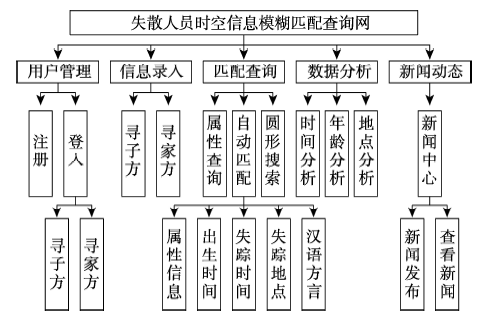
Fig. 7 The structure of the query system of lost

图7 失散人员信息查询系统结构框架图

其中,自动匹配查询功能是以失散匹配方的信息为基础,利用上述失散人员信息时空模糊匹配度模型计算结果,显示匹配度大于0.35的信息,标注于地图的相应位置。地图按照地点信息和方言信息将区域分为7个等级显示,并以颜色深浅来鉴别各个等级,点击图标显示对应数据的详细信息(图8)。
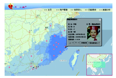
Fig. 8 Matching query function map of people informationlost people information query system

图8 失散人员信息查询系统匹配查询功能图

7 结论

本文针对失散人员信息不完善和以往查询方式的不足,引入模糊时空范围分级和年龄记忆模糊度的概念,提出适用于失散人员的汉语方言分区,建立失散人员信息时空模糊匹配度计算模型。并结合时间地理学的时空棱镜和时空路径工具,设计了模型时空修正方法,以此判别匹配结果是否在失散匹配方可能到达的时空范围内。本文还将WebGIS 技术与富客户端开发技术结合起来,建立了失散人员信息的综合模糊查询系统,并设计案例进行验证。结果表明,该模型能筛选出匹配度较高的 信息。
然而,该模型在实际应用中仍存在许多不足之处。人员失散和搜寻的实况非常复杂,不仅受到长期记忆模糊性的影响,还受到交通干线和贩卖需求分布的影响。下一步研究工作拟考虑贩卖需求地和城市格局发展变化等因素对买/卖空间关系时空分布的影响,以及失踪时间段存在的城市交通干线对失散过程的影响,并以此为依据缩小失踪地点和出生地点范围。该计算模型分不同年龄段对失散人员的信息准确度进行分析,主要适用于失踪儿童的分析和匹配,应关注其他年龄层特征。对于权重的设置,可以输入匹配成功的案例,用支持向量机或机器学习方法进行训练,以更科学地确定各个因子的权重。失散人员的方言口音往往是指导其匹配的重要因素,本文仅使用了方言口音类型,对于语言用法细节的研究还不够完善。因此,将标志性方言用法分布应用于失散人员匹配也是下一步研究的重点。

The authors have declared that no competing interests exist.

[1]
国家统计局.中国统计年鉴[M].北京:中国统计出版社,2004-2014.

[ National Statistical Office.China statistical yearbook [M]. Beijing: China Statistics Press, 2004-2014. ]

[2]
袁蓉,朱秋安.完善我国打拐DNA数据库管理的思考[J].东南司法评论,2015,8(10):84-92.

[ Yuan R, Zhu Q A.Thoughts on perfecting the management of DNA database in China[J]. Southeast Judicial Commentary, 2015,8(10):84-92. ]

[3]
王建明. 基于人脸识别算法的失踪乞讨儿童检索系统的设计与实现[D].广州:中山大学, 2012.

[ Wang J M.Design and implementation of children's retrieval system based on face recognition algorithm[D]. Guangzhou: Sun Yat-Sen University, 2012. ]

[4]
刘持标,林金发,孙丽丽,等.基于Android图像识别技术的失踪人员管理系统开发[J].三明学院学报,2014,31(4):17-23.针对我国目前由于地域广及流动人口多所导致的失踪人员难以寻找的问题,利用Android智能手机摄像、GPS、Open CV、Java CV、Java、Java EE、My Sql等技术开发基于Android图像识别技术的失踪人员管理系统。利用此系统和Wi Fi或3G/4G移动通信技术,Android智能手机可针对潜在的搜寻目标照相,并将照片及GPS相关信息即刻传输到远程数据服务中心的服务器。收到查询图像后,服务器立刻对图像进行处理并同图像库中的人员信息进行对比,从而确定刚刚拍摄到的人员是否为所寻找的目标。该系统的开发为建立全社会人人都可以参与的实时人员搜寻系统奠定了基础,为在较短时间内寻找到失踪人员提供了技术保障,具有较大的经济意义和社会意义。

DOI

[ Liu C B, Lin J F, Shun L L, et al.Development of missing personnel management system based on android image recognition technology[J]. Journal of Sanming College, 2014,31(4):17-23. ]

[5]
Eden A, Christoudias C M, Darrell T.Finding lost children[C]// Person-Oriented Vision. IEEE, 2011:7-12.

[6]
Wan Q.Human visual system based facial recognition for autonomous systems and applications[D]. Medoford: Tufts University, 2015.

[7]
陈飞. 基于Hadoop平台的失踪乞讨儿童检索系统的设计与实现[D].广州:中山大学,2012.

[ Chen F.Design and implementation of Children’s retrieval system based on hadoop platform[D]. Guangzhou: Sun Yat-Sen University, 2012. ]

[8]
陈逸菲,秦小麟,李博涵.不确定移动对象的模糊时空范围查询[J].计算机研究与发展,2012,49(10):2161-2170.指出不确定性和模糊性在时空语义上的区别;提出不确定移动对象的模糊时空范围查询问题,即查询条件中时间、空间范围的外延是模糊的,无清晰的边界,而目标对象的位置不确定;用模糊集表示模糊查询条件,概率密度函数表示移动对象在各自不确定区域内的可能位置分布;给出了不确定对象关于模糊查询条件匹配度的计算方法;设计了基于a截集的无效对象排除和有效对象确认规则及查询算法.算法规则适用于任意概率密度分布.现有的确定或不确定范围查询可以看成是模糊时空范围查询的特例.通过实验验证了算法的效率,在各种参数设置下,约有30%~90%的查询结果可在不计算匹配度的情况下获得.

[ Chen Y F, Qin X L, Li B H.The fuzzy spatio-temporal range query of uncertain moving objects[J]. Computer Research and Development, 2012,49(10):2161-2170. ]

[9]
柏禄一,严丽,马宗民.模糊时空XML数据拓扑关系表示和确定的研究[J].东北大学学报(自然科学版),2013,34(6):782-785.

[ Bai L Y, Yan L, Ma Z M.Research on representation and determination of topological relation of xml data in fuzzy spatio - temporal[J]. Journal of Northeastern University (Natural Science Edition), 2013,34(6):782-785. ]

[10]
柏禄一,严丽,马宗民.基于XQuery符号表示法的模糊时空数据查询[J].东北大学学报(自然科学版),2013,34(4):505-508.

[ Bai L Y, Yan L, Ma Z M.Fuzzy spatial-temporal data query based on XQuery symbol representation[J]. Journal of Northeastern University (Natural Science Edition), 2013,34(4):505-508. ]

[11]
侯志伟,诸云强,高星,等.时间本体及其在地学数据检索中的应用[J].地球信息科学学报,2015,17(4):379-390.高效、准确地获取目标数据及其关联数据,是决定大数据共享与挖掘分析能否实现的关键因素。传统的数据检索方法无法利用地学数据间的显性或隐含关系,已不能满足日益增长的对检索结果质和量的需求,而本体理论和技术的语义检索成为当前的研究热点。本文针对时间这一地学数据的本质属性,在系统研究地学数据时间概念与特征的基础上,建立了地学数据时间本体模型,并深入论述了模型中的时间关系、时间坐标系等内容,提出了时间位置和时间距离的描述函数,同时研究了二者的本体表达方式。构建了包括地质年代等在内的地学数据时间本体库,并以语义网开发框架Jena为基础,经本体解析、元数据时间信息抽取与标注等过程,将时间本体应用于地球系统科学数据共享平台的元数据检索之中。结果表明,以时间本体的地学数据语义检索查全率约为关键字方法的1倍,检索结果排序,以及关联数据推荐方面也有更好的效果,为促进地学数据共享与关联发现提供了一种有效的方法。

DOI

[ Hou Z W, Zhu Y Q, Gao X, et al.Time ontology and its application in geoscience data retrieval[J]. Geo-information Science, 2015,17(4):379-390. ]

[12]
Maceachren A M, Wachowicz M.Constructing knowledge from multivariate spatiotemporal data: integrating geographical visualization with knowledge discovery in database methods[J]. International Journal of Geographical Information Science, 1999,4(13):311-334.We present an approach to the process of constructing knowledge through structured exploration of large spatiotemporal data sets. First, we introduce our problem context and define both Geographic Visualization (GVis) and Knowledge Discovery in Databases (KDD), the source domains for methods being integrated. Next, we review and compare recent GVis and KDD developments and consider the potential for their integration, emphasizing that an iterative process with user interaction is a central focus for uncovering interest and meaningful patterns through each. We then introduce an approach to design of an integrated GVis-KDD environment directed to exploration and discovery in the context of spatiotemporal environmental data. The approach emphasizes a matching of GVis and KDD meta-operations. Following description of the GVis and KDD methods that are linked in our prototype system, we present a demonstration of the prototype applied to a typical spatiotemporal dataset. We conclude by outlining, briefly, research goals directed toward more complete integration of GVis and KDD methods and their connection to temporal GIS.

DOI

[13]
Bigolin N M, Marsala C.Fuzzy spatial OQL for fuzzy knowledge discovery in databases[C]// European Symposium on Principles of Data Mining and Knowledge Discovery. Springer-Verlag, 1998:246-254.

[14]
Huang B, Claramunt C.Spatiotemporal data model and query language for tracking land use change[J]. Transportation Research Record Journal of the Transportation Research Board, 2005,1902(1):107-113.Abstract Management of spatiotemporal information requires a more generic and consolidated data model to facilitate applications such as tracking land use parcel changes. This paper presents such a spatiotemporal data model in the context of object databases by extending the Object Data Management Group (ODMG) standard and examines its feasibility in a land use application. This model extends the ODMG object model with a parameterized type, TimeSeries〈T〉 , which allows the shifting of spatial types into spatiotemporal types to support the representation of a series of states (i.e., the history) of an object. An object query language (OQL), spatiotemporal OQL (STOQL), which adds spatial and temporal dimensions to ODMG's OQL, is also designed. A case study demonstrates that STOQL supports the formulation of various spatiotemporal queries pertaining to historical states of spatial objects as well as spatial changes, including spatial type substitution. The model and query language have been implemented by using an object-oriented language in a geographic information system environment.

DOI

[15]
Delafontaine M, Neutens T, Nico V D W. Modelling potential movement in constrained travel environments using rough space-time prisms[J]. International Journal of Geographical Information Science, 2011,25(9):1389-1411.The widespread adoption of location-aware technologies (LATs) has afforded analysts new opportunities for efficiently collecting trajectory data of moving individuals. These technologies enable measuring trajectories as a finite sample set of time-stamped locations. The uncertainty related to both finite sampling and measurement errors makes it often difficult to reconstruct and represent a trajectory followed by an individual in space–time. Time geography offers an interesting framework to deal with the potential path of an individual in between two sample locations. Although this potential path may be easily delineated for travels along networks, this will be less straightforward for more nonnetwork-constrained environments. Current models, however, have mostly concentrated on network environments on the one hand and do not account for the spatiotemporal uncertainties of input data on the other hand. This article simultaneously addresses both issues by developing a novel methodology to capture potential movement between uncertain space–time points in obstacle-constrained travel environments.

DOI

[16]
Miller H J.A measurement theory for time geography[J]. Geographical Analysis, 2005,37(1):17-45.Abstract H gerstrand's time geography is a powerful conceptual framework for understanding constraints on human activity participation in space and time. However, rigorous, analytical definitions of basic time geography entities and relationships do not exist. This limits abilities to make statements about error and uncertainty in time geographic measurement and analysis. It also compromises comparison among different time geographic analyses and the development of standard time geographic computational tools. The time geographic measurement theory in this article consists of analytical formulations for basic time geography entities and relations, specifically, the space鈥搕ime path, prism, composite path-prisms, stations, bundling, and intersections. The definitions have arbitrary spatial and temporal resolutions and are explicit with respect to informational assumptions: there are clear distinctions between measured and inferred components of each entity or relation. They are also general to n- dimensional space rather than the strict two-dimensional space of classical time geography. Algebraic solutions are available for one or two spatial dimensions, while numeric (but tractable) solutions are required for some entities and relations in higher dimensional space.

DOI

[17]
刘钊,罗智德,张耀方,等.基于GIS的时空节点规划与优化方法研究[J].地理与地理信息科学,2014,30(1):41-44.时间地理学框架描述了个体行为的时间和空间约束,可用于确定活动双方的时空交集并进行定量的时空分析。该文分析了活动预约双方的时间和空间限制条件,根据个体时空约束类型的不同分别将其表达为时空路径、圆柱和棱镜。在此基础上,将求解活动双方会面的时空节点问题转换为求解双方的时空交集,并在ArcGIS环境中得以实现。这种基于时间地理学和GIS技术进行时空节点规划和优化的方法可应用于应急救灾、物流配送、旅游规划等领域,辅助实现对时间和地点的预约及对路径的优化,进而提高效率、节约成本。

DOI

[ Liu Z, Luo Z D, Zhang Y F, et al.Research on spatial and temporal node planning and optimization based on GIS[J]. Geography and Geography Information Science,2014, 30(1):41-44. ]

[18]
赵莹,柴彦威,陈洁,等.时空行为数据的GIS分析方法[J].地理与地理信息科学,2009,25(5):1-5.

[ Zhao Y, Chai Y W, Chen J, et al.The GIS analysis method of time and space behavior data[J]. Geography and Geography Information Science,2009,25(5):1-5. ]

[19]
詹伯慧. 方言分区问题再认识[J].方言,2002,24(4):344-352.汉语方言分区问题近年仍存在某些争议,有必要对相关问题进一步展开讨论.本文先就汉语方言如何分区论及方言界限的划分与方言分区的区别、汉语方言分区的原则和依据、区分汉语方言的语言条件等问题,再讨论汉语方言分区的层次和格局,并提出根据汉语方言的现实状况具体划分汉语方言区的意见.

DOI

[ Zhang B H.Re-cognition of the problem of dialect[J]. Dialect, 2002,24(4):344-352. ]

[20]
陈逸菲. 位置不确定移动对象查询处理关键技术研究[D].南京:南京航空航天大学,2013.

[ Chen Y F.Research on key technology of mobile object query processing in uncertainty[D]. Nanjing: Nanjing University of Aeronautics and Astronautics, 2013. ]

[21]
李小凡. 汉语方言分区方法再认识[J].方言,2005,27(4):356-363.本文重新审视以往关于汉语方言分区的各种意见,将方言分区分解为划类和鉴别两个不同的步骤.先进行划类,分出典型方言区;然后再鉴别,将典型方言区之外的剩余地区分别归入典型方言区;既非典型方言,又难以归入典型方言的剩余地区,视为方言过渡区或混合方言区.

DOI

[ Li X F.Reconsideration of Chinese dialect zoning method[J]. Dialect, 2005,27(4):356-363. ]

[22]
张光宇. 东南方言关系综论[J].方言,1999(1):33-44.

[ Zhang G Y.A summary of the relationship between southeast dialects[J]. Dialect, 1999,1:33-44. ]

[23]
蔡梦月. 云南寻甸县汉语方言分区研究--以各乡镇方言声调为分区标准[J].现代语文旬刊,2013(3):42-43.寻甸县位于云南省东北部,寻甸汉语方言属于北方方言区西南官话中的云南滇中方言。本文以县内各乡镇方言的声调为分区标准,将寻甸汉语方言分为两个大区,一个过渡区。

[ Cai M Y. A Study on the chinese dialects in xundian county, Yunnan province-a case study of township dialect tones[J]. Modern Languages, 2013(3):42-43. ]

[24]
秋谷,裕幸.福建南平王台方言的归属[J].方言,2010(4):338-345.

[ Qiu G, Yu X.Fujian Province Nanping Wang Tai dialect attribution[J]. Dialect,2010,4:338-345. ]

[25]
李慕寒. 汉语方言的地理分布及其研究意义[J].人文地理,1992,10(1):12-17.

[ Li M H.The geographical distribution of Chinese dialects and its significance[J]. Human Geography, 1992,10(1):12-17. ]

[26]
刘新中,杨蔚,崔淑慧. 关于汉语方言分区的语言条件[J].语言研究,2003(3):113-118.

[ Liu X Z, Yang W, Cui S H.On the language condition of chinese dialects[J]. Language Research, 2003,3:113-118. ]

[27]
刘岩. 记忆监测的发生发展[D].北京:北京大学,2008.

[ Liu Y.The development of memory monitoring[D]. Beijing: Peking University, 2008. ]

[28]
Abi-Zeid I, Frost J R.SARPlan: A decision support system for canadian search and rescue operations[J]. European Journal of Operational Research, 2005,162(3):630-653.We present SARPlan, a geographic decision support system designed to assist the Canadian Forces in the optimal planning of search missions for missing aircraft. Its primary purpose is to ensure that the available search resources are deployed in a way that will maximize the mission's probability of success. The optimization modules are based on search theory, on gradient search methods and on constraint satisfaction programming. We include results that demonstrate that SARPlan improves the performance when compared to the current manual method. This improvement translates to an increase in the chances of finding lost aircraft and survivors, resulting in more saved lives. Another benefit of using SARPlan is a potential decrease in the operations costs. In 2001, SARPlan was the winner of three prestigious excellence awards in the information technology domain.

DOI

[29]
Miller H J, Bridwell S A.A field-based theory for time geography[J]. Annals of the Association of American Geographers, 2009,99(1):49-75.Classic time geography is powerful but rigid, admitting only uniform travel velocities. Computational time geographic methods that resolve the uniform velocity assumption through transportation networks or isochrones only partially address this weakness and do not have a rigorous theoretical foundation. This article develops an analytical time geographic theory for the case where travel velocities vary continuously across space. Using the continuous transportation or “urban fields” tradition in quantitative geography and regional science, this article formulates analytical definitions of the space–time path and prism for the case where unobserved components are characterized by minimum cost curves through an inverse velocity field rather than straight line segments through a uniform velocity plane. This provides a geometrically and visually oriented approach to capturing complex velocities that complements existing methods. Time geographic fields also generalize time geography as the classic and isochrone versions are special cases; these now have a rigorous analytical foundation. It also can extend the network approach by treating links as regions with continuously varying velocities. Time geographic fields are also useful for nonnetwork-constrained phenomena such as movement through terrain, water, and air. This article illustrates the approach using a computational implementation based on a lattice approximation.

DOI

[30]
Hongbo Y.Spatio-temporal GIS design for exploring interactions of human activities[J]. Cartography & Geographic Information Science, 2006,33(1):3-19.An effective representation of human activities in geographic information systems (GIS) presents a challenging research topic. Recent developments of information and communication technologies (ICT), which enable a virtual space and allow people to interact with others remotely, make such efforts even more difficult. This paper first extends the space–time path concept of H01gerstrand's time geography to represent both physical and virtual activities in a space–time context. A spatio-temporal GIS design which can accommodate the extended space–time path concept is proposed to support the exploration of spatio-temporal patterns of human interactions in physical and virtual spaces. Using time as a linear referencing system, a temporal dynamic segmentation method was developed to dynamically locate physical and virtual activities on space–time paths. The GIS design supports the identification of four different spatio-temporal patterns (i.e., co-existence, co-location in space, co-location in time, and no co-location in either space or time) of human interactions through their space–time paths. Using a hypothetical activity dataset, a prototype system is implemented as a three-dimensional GIS (i.e., two-dimensional space + one-dimensional time) in ArcGIS. The prototype system demonstrates the feasibility and potential of applying spatio-temporal GIS concepts to extend Hagerstrand's time–geographic framework for the representation and analysis of human interactions in both physical and virtual spaces. The proposed GIS design can be useful in such applications as understanding traffic congestion, tracking terrorist activities, and modeling the spread of infectious diseases.

DOI

[31]
吕国勇,史祥龙.基于GIS的生命探测监控系统模型[J].计算机应用,2013,33(s1):267-270.针对地震、车祸、矿难、火灾等突发事故提供一套协助于人员搜救类工作的指挥调度软件系统,该系统能在事故发生初期对灾害区域人员进行生命探测,探测出未被及时发现的受害人员并将相应的现场信息(包括受害人员位置信息、现场状况、搜救工作人员信息等)通过无线网络传输到指挥调度中心的地理信息系统(GIS)监控平台,通过GIS监控平台的智能分析,能够直观、高效地实现搜救人员指挥调度管理,迅速地响应搜救方案。通过在原型系统模型上面模拟测试,结果表明:该方案能够较好地为搜救类工作的指挥调度服务。

[ Lv G Y, Shi Y L.Based on GIS life detection and monitoring system model[J]. Journal of Computer Applications, 2013,33(s1):267-270. ]

[32]
Shaw S L, Yu H.A GIS-based time-geographic approach of studying individual activities and interactions in a hybrid physicalvirtual space[J]. Journal of Transport Geography, 2009,17(2):141-149.Modern information and communication technologies (ICT) are changing human activity and travel patterns that could have significant implications to our everyday lives and the human organization of space.Time geography,which examines human activities under various constraints in a space-time context,provides a useful framework to analyze the complex spatio-temporal relationships among activities and interactions taking place in both physical and virtual spaces.However,virtual activities and interactions conducted via ICT have characteristics that cannot be properly represented and analyzed under the classical time-geographic framework.This paper extends classical time-geographic concepts to accommodate the needs of representing and analyzing all activities and interactions in a hybrid physical-virtual space.In addition,this paper presents a space-time geographic information system (GIS) design that is capable of organizing complex activity and interaction data as spatio-temporal processes in an integrated space-time environment.This space-time GIS design offers a useful analytical environment for researchers to study increasingly dynamic human activity and travel patterns in today's society and their implications toward changing travel demand patterns from both spatial and temporal perspectives.

DOI

Outlines

/