Orginal Article

Review on the Simulation of Non-Point Source Pollution in the Hilly Region of Southern China

  • GAO Huiran , 1, 2 ,
  • SHEN Lin 3, 4, 5 ,
  • LIU Junzhi , 3, 4, 5, * ,
  • ZHU Axing 1, 2, 3, 4, 5, 6 ,
  • QIN Chengzhi 1, 5 ,
  • ZHU Liangjun 1, 2
Expand
  • 1. State Key Lab of Resources and Environmental Information System, Institute of Geographic Sciences and Natural Resources Research, Chinese Academy of Sciences, Beijing 100101, China
  • 2. University of Chinese Academy of Sciences, CAS, Beijing 100049, China
  • 3. Key Laboratory of Virtual Geographic Environment, Ministry of Education, Nanjing Normal University, Nanjing 210023, China
  • 4. State Key Laboratory Cultivation Base of Geographical Environment Evolution (Jiangsu Province), Nanjing 210023, China
  • 5. Jiangsu Center for Collaborative Innovation in Geographical Information Resource Development and Application, Nanjing, 210023, China
  • 6. Department of Geography, University of Wisconsin-Madison, Madison WI 53706, USA;
*Corresponding author: LIU Junzhi, E-mail:

Received date: 2017-03-28

  Request revised date: 2017-05-20

  Online published: 2017-08-20

Copyright

《地球信息科学学报》编辑部 所有

Abstract

With the increase of economic development, water quality degradation caused by non-point source pollution has become a serious problem in the hilly region of southern China. It is hard to set up controllable experimental environment at the watershed scale due to the complexity of non-point source pollution processes. Model simulation has become an effective way to facilitate watershed management and planning. Related studies on the simulation of non-point source pollution have been conducted in this region. However, few works have been done to summarize the outcomes of shortcomings of these studies and to point out the future research directions. Firstly, this paper analyzed the physical mechanism of non-point source pollution and regional characteristics such as special land features, human activities in this region and pointed out that the simulation methods of non-point source pollution in this region should meet the following demands: (1) coupling multiple watershed processes such as hydrology, soil erosion, plant growth and the migrating and transforming of non-point source pollutants; (2) spatially fully distributed in order to express the spatial heterogeneity of non-point source pollutant loading, and describe the migration and transformation routes of pollutants explicitly in this region; (3) taking the special land features and human activities into consideration which have important effects on the process of non-point source pollution. Then, based on the above demands, this paper summarized the current studies on the aspects of migration routes modeling and the representation of special land features and human activities in this region, and analyzed the problems of existing methods for non-point source pollution modeling that applied in the hilly region of southern China. On the aspect of spatial discretization, current methods cannot accurately describe the spatial heterogeneity of non-point source pollution processes, and the modeling of pollutant transport routes is limited to semi-distributed approaches which can’t describe the exchange relationship of material and energy among adjacent spatial units at the hillslope scale. On the aspect of describing the regional characteristics, some watershed processes that are special in this region are absent in the current models. At last, future research directions were discussed on the following aspects: (1) Strengthen the description of the special landscape features, and explore the method of spatial discretization that suitable for hilly region of southern China; (2) Improve the construction of the fully-distributed migration routes of non-point source pollutants; (3) Conduct comprehensive representation of special land features and human activities in the fully-distributed non-point source pollution model. This paper aims to provide references to the simulation of non-point source pollution in the hilly region of southern China, which can then serve as an effective tool for scientific watershed management.

Cite this article

GAO Huiran , SHEN Lin , LIU Junzhi , ZHU Axing , QIN Chengzhi , ZHU Liangjun . Review on the Simulation of Non-Point Source Pollution in the Hilly Region of Southern China[J]. Journal of Geo-information Science, 2017 , 19(8) : 1080 -1088 . DOI: 10.3724/SP.J.1047.2017.01080

1 引言

中国南方丘陵区内水库密布,多位于流域上游,这些水库承担着区域水源地的重要功能,是中国当前建设“水质良好湖泊”的重点区域[1-2]。随着近年来该地区开发利用强度的增大,氮磷污染和水体富营养化问题日益突出,直接威胁区域饮用水水源安全,故流域水环境保护和污染治理迫在眉睫[3-4]
南方丘陵区的工厂排污等点源污染较少,农业、养殖业和生活污水等引起的非点源污染是该地区水环境问题的主要原因[5]。由于非点源污染具有较大的随机性和较强的空间异质性、流域过程机理复杂多样等特点,使其治理难度很大[6-7]。在田间尺度,小范围的野外观测和实验可以为非点源污染治理提供科学依据,但在流域尺度,由于流域系统的复杂性,难以建立大范围、重复可控的观测和实验环境,模型模拟成为非点源污染治理辅助决策的必要手段[8-10]。通过对流域非点源污染过程及其对管理措施的响应进行定量模拟,可有力拓展观测实验结果的时空尺度,在无需大范围实地观测的情况下识别污染物来源和迁移转化过程,具有效益高、灵活性强的优点[11-12]。自20世纪80年代以来,研究者们将地理信息系统、卫星遥感与较早期的一些经验统计模型进行集成,针对非点源污染治理与模拟开展许多深入的研究工作[13],研发了一系列非点源污染模型,如WEPP、AGNPS、SWAT、AnnAGNPS、HSPF等[14-16],并在非点源污染、水文响应研究、资源可持续利用等重大问题研究中得到广泛的应用[17-19]
当前,已有研究者针对南方丘陵区的非点源污染过程模拟开展了相关研究,并取得了一定成果[20-22]。但是,尚缺乏对这些已有研究成果及其所存在问题的系统总结以及对进一步研究方向的分析探讨。鉴于此,本文首先分析了南方丘陵区非点源污染过程的机理及其对模拟方法的要求,然后总结了现有研究中存在的问题,并对下一步研究方向进行展望,以期为南方丘陵区的非点源污染过程模拟研究提供借鉴和参考。

2 研究区概况

中国南方丘陵区位于东经105°~120°,北纬23.5°~33°之间,主要指华南丘陵区、云南丘陵区、四川盆地中部丘陵和东南部丘陵等低山地地区。按照行政区划界线计算,包括湖南、江西、广东、浙江、福建等15个省(自治区)的部分或全部地区,大多由东北至西南走向的低山丘陵和河谷盆地相间分布。
南方丘陵区低山丘陵分布广泛,约为区域总面积的76%,海拔多在500 m以下。该区域位于亚热带季风气候、热带湿润季风气候区内,气候资源十分丰富。区域内河流众多,水系发达,是中国水库分布最为集中的区域之一。目前,南方丘陵区共有大型水库173座,总库容1420×108 m3,占全国总量的25.3% [1]。从全球尺度来看,受副热带高压的影响,处于南、北回归线附近大部分地区形成了大范围的干旱草原或沙漠区,但中国南方丘陵地区东接东海,南临南海,受太平洋季风影响,表现出强烈的地域性。
南方丘陵地区自然资源丰富,人口密集。近年来,该区域的人口增长、经济发展导致人地矛盾日益突出,由于长期对该地区资源的不合理开发利用,南方丘陵区巨大的气候、资源等优势未能充分发挥,区域的水土流失加剧,生态环境破坏严重。资料统计显示,南方丘陵区的水土流失面积达 18.4万km2,占土地总面积的21.4%,其严重程度仅次于黄土高原[24]。大量的水土流失造成土壤养分(氮、磷等)大幅度流失,增加河流与水库的污染物浓度,使得水体富营养化严重。此外,传统有机肥直接排放、农村有机废弃物污染、畜禽养殖数量和规模继续增加以及当地居民对生活污水的大量排放等导致河流和水库污染,对水库水环境产生了显著的负面影响。特别是该区域经济、生活与生产方式的改变,非点源污染源分布广泛而且分散,大型污水处理设备无法发挥作用,使南方丘陵区水环境保护压力持续增加[23]。由此可见,南方丘陵区非点源污染问题十分严峻,水资源污染治理迫在眉睫。

3 中国南方丘陵区非点源污染模拟 研究现状

3.1 中国南方丘陵区非点源污染模拟的要求

(1)非点源污染过程模拟的共性机理
从流域过程的角度看,非点源污染的发生、迁移和转化涉及降水-径流、土壤侵蚀、植物生长和养分循环等众多过程。在降水-径流过程中,可溶性氮、磷污染物随地表径流、壤中流和地下水流发生迁移,吸附态的氮、磷等污染物附着在泥沙表面上随土壤侵蚀和输移过程发生迁移,在污染物迁移的同时伴随着污染物的转化和植物对养分的吸收。因此,要实现非点源污染过程模拟的全面性和合理性,需要综合考虑所涉及的众多流域过程,进行多过程耦合模拟。
从地理空间的角度看,非点源污染的产生、迁移等过程具有显著的空间异质性。在不同空间位置上,因气候、地形、土壤、植被和人为等因素的不同,非点源污染负荷存在很大差异;同时,非点源污染物在迁移过程中可能汇集上游单元产生的污染物或者被下游单元拦截,也会影响污染物转化(如硝化、反硝化作用)和植物吸收等过程,所以污染物空间迁移路径的不同会显著影响非点源污染物的输出量[25-27]。精细刻画污染物产生和迁移转化过程,需要详细描述污染物负荷的空间分布,并刻画污染物与迁移路径上各空间单元的相互作用关系[28-29]。因此,非点源污染过程模拟模型在空间上应为全分布式。
(2)中国南方丘陵区非点源污染过程的区域 特点
南方丘陵区广泛存在水田、水塘等特殊地物和农田灌溉排水等人为活动,这些特殊地物和人为活动改变了自然条件下水流和污染物的迁移路径和转化过程(图1)。例如,水田由田埂包围,通过进出水口高度控制水田中的水层高度,具有一定蓄水能力。在水田的蓄水期,满足下渗后的降水或灌溉水被蓄积在田中,当水量超过最大储流量时,多余水量才通过排水渠汇入下游水塘或邻近河流,这显著改变了自然条件下非点源污染物随水流的迁移转化过程。水塘能够收集降水和上游集水区的径流,在非灌溉情况下,只有水量超过水塘容量时,多余水量才以地表径流方式流入下游水塘或邻近河流,从而对上游径流中的氮、磷污染物具有一定截留作用。人为的灌溉活动则会将水塘中的非点源污染物输移到水田,农田排水活动则会将农田中的非点源污染物释放到水塘或河流,从而对污染物的迁移路径产生较大影响。合理模拟南方丘陵区的非点源污染过程,需要充分考虑区域内这些特殊地物和人为活动的影响[32-33]
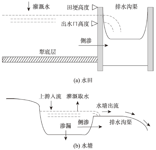
Fig. 1 The effect of paddy field and reservoir on migration path of water

图1 水田和水塘对水流迁移路径的影响

综上所述,基于非点源污染过程的共性机理和区域特点,南方丘陵区非点源污染过程模拟应满足如下3个要求:① 耦合降雨-径流、土壤侵蚀、植物生长与非点源污染物迁移转化等多个流域过程;② 空间全分布式模拟,能够表达非点源污染物负荷的空间异质性,精细刻画污染物在空间上的迁移转化路径;③ 考虑南方丘陵区特殊地物和人为活动对非点源污染过程的影响。

3.2 现有非点源污染模型在中国南方丘陵区的直接应用

已有研究者利用SWAT、AnnAGNPS和HSPF等现有非点源污染模型在中国南方丘陵区进行非点源污染模拟(表1),且这些模型已在国外相关研究中得到验证,例如,Lamba等以美国威斯康星州中南部的小流域为例,利用SWAT模型在子流域尺度上对耕地进行关键源区的识别和泥沙、总磷污染等负荷的评估,表明SWAT模型能够准确预测径流量、含沙量和总磷负荷量[34]。在利用这些模型进行中国南方丘陵区的非点源污染模拟方面,荣琨等运用SWAT模型,以晋江西溪流域为例模拟了不同植被情景下的非点源污染响应,结果表明SWAT模型可以较好的模拟植被恢复后流域非点源污染的变 化[35];高菲等将AnnAGNPS模型运用于太湖流域典型丘陵区(梅林小流域),进行农业非点源污染数值模拟,结果表明模型预测结果与实际观测结果基本相符,相关程度较高[36];李燕等在分析了径流模拟关键参数敏感性的基础上,评价了HSPF模型在太湖丘陵地区的适用性,结果验证该模型模拟精度很好,具有较好的适用性[37];徐幸仪等构建了镇江丘陵区句容水库流域SWAT模型,研究该流域土地利用对氮素输移的影响,结果表明SWAT模型模拟结果较为理想[38];刘洁等应用HSPF模型定量分析了东江流域非点源污染的时空分布特征,结果表明所建立的基于HSPF的模型可以满足该流域非点源污染长期变化过程与时空分布特征的研究需要[39]。这些已有模型较为全面地考虑了非点源污染相关的降水-径流、土壤侵蚀、植物生长和污染物迁移转化等多个过程,能在一定程度上体现影响非点源污染负荷的空间异质性,直接利用这些模型在南方丘陵区进行非点源污染过程模拟也能得到较好的模拟效果。
在对污染物迁移过程的描述和对区域特点的考虑方面,现有模型存在较大不足:① 当前用于南方丘陵区非点源污染过程模拟的模型大多为半分布式模型。该类模型一般采用水文响应单元为基本模拟单元,将子流域内部具有相同土地利用、土壤类型和地形特征等要素的斑块看作一个整体,通过单位线等汇流方法将水文响应单元上产生的污染物直接累加至河道,没有空间单元间的物质交互,从而无法体现坡面尺度上污染物迁移路径对其迁移转化过程的影响[40-43]。② 直接应用于南方丘陵区非点源污染过程模拟的现有模型,大都基于国外的环境特点研发,很多模拟方法不适应中国南方丘陵区的特点,例如在土壤侵蚀中广泛使用的RUSLE方法主要针对平原区或缓坡地区建模,不符合中国南方丘陵区的地形特征,在应用中受到较大约束;SWAT模型在对地物形状的表达方面,虽然该模型中类型为 “Pothole”(坑洞)的水文响应单元可用于水田的近似模拟,但是SWAT模型中假设该类型单元的形状为锥形,与水田的实际情况不符[44-46];在水田水量平衡的表达方面,SWAT模型对水田犁底层影响入渗过程的描述不充分,也没有反映水田不同蓄水阶段入渗、蒸发等过程的差异。
Tab. 1 Non-point source pollution models that are most commonly used in China

表1 国内使用较多的非点源污染模型及其特点

模型名称 模型优点 模型限制 模型类型
HSPF 连续模拟氮、磷和农药等污染物的迁移转化;
考虑复杂的污染物平衡关系;模拟输出多种形式的污染负荷
实用性有较大限制;模拟空间分辨率较低;不适于流域过程长期模拟 半分布式
AnnAGNPS 模拟次降雨下的流域尺度地表径流污染负荷和氮、磷流失;
连续模拟地下水养分平衡
忽略河道沉积泥沙吸附态污染物,总磷模拟存在较大的不稳定性 半分布式
SWAT 可在资料空乏区建模;模拟大面积复杂流域的径流、泥沙负荷和污染物质迁移;QUAL2E养分迁移模型 日模拟存在系统误差;输出形式为总负荷量;某些描述(如河床)过于简化,有待改进 半分布式

3.3 对非点源污染模型改进应用

改进流域过程模型使其更符合区域特点是非点源污染模拟研究的常用方法。例如,Duke等考虑道路和水渠等线状特殊地物对水流路径的影响修正水流的方向[47];Gascuel-Odoux等根据田边的树篱和道路修正水流方向,以准确反映非点源污染物等随水流在田边受到树篱和道路阻挡而沿其流动的现象[48]。中国南方丘陵区由于较强的地域性特征,非点源污染过程受多种特殊地物和人为活动的影响,针对南方丘陵地区,国内相关学者对已有非点源污染模型进行了改进应用研究。胡远安等考虑水田的不同蓄水阶段,改进了SWAT模型中入渗和蒸发过程的模拟方法,提高了长期径流模拟的精 度[49];代俊峰等、Xie等改进了SWAT模型中水田的空间表达和水田表面积的计算方法,增加了对水塘集水和灌溉等过程的模拟[22,50];王建鹏等在上述研究基础上,进一步改进了水田入渗和水塘灌溉等过程的模拟方法,与原SWAT模型相比,改进后模型的各项评价指标(相对误差、纳什系数等)均有明显提高[43];杨丽雅等应用简化的SWAT模型模拟漓江支流某小流域非点源污染的负荷量,并对模型的适用性做出评价,研究结果表明模型模拟效果良 好[51]。这些考虑区域特点对非点源污染模型的改进使模型模拟更符合实际地理过程。
但是现有的模型改进研究均基于半分布式模型,虽然在一定程度上表达了空间单元间的物质交换关系,但仍然未能详细描述水流和非点源污染物在空间上的迁移路径和迁移转化过程,不能有效支撑流域过程模拟相关应用。另外,现有研究只考虑水文过程的区域特点进行模型改进,较少考虑植物生长等其他过程的区域特点(如水稻在不同生长阶段对养分的吸收机制不同)。

3.4 中国南方丘陵区非点源污染模拟存在的问题

综上所述,中国南方丘陵区非点源污染模拟所存在的主要问题包括:
(1)现有应用于南方丘陵区的非点源污染模型主要采用水文响应单元的方式进行空间离散化,但该区域存在各种影响水流和污染物迁移且形状多样的特殊地物(如水塘、水田等),水文响应单元不能准确刻画非点源污染相关过程的空间异质性[52]
(2)当前非点源污染过程模拟中对污染物迁移路径的建模还限于半分布式,没有详细描述坡面尺度迁移路径上各空间单元之间的物质和能量交换关系。例如,下游单元拦截上游单元的污染物,或下游单元的污染物被上游入流携走等,不能体现非点源污染过程中的空间相互作用关系,模拟的合理性和可靠性受限。
(3)南方丘陵区广泛存在的水田、水塘等特殊地物和农田灌溉排水等人为活动对非点源污染过程的影响需要在模型中合理的表达,但是现有非点源污染模型中对上述特殊地物和人为活动的表达方法尚不完善。

4 结论与展望

模型模拟是非点源污染治理辅助决策的重要手段。本文对南方丘陵区非点源污染模拟相关研究进行了总结和分析,指出当前研究中存在的一些问题。今后需进一步研究的问题包括:
(1)加强对区域特征的刻画,研究适合南方丘陵区的流域空间离散化方法。流域空间离散化是分布式非点源污染过程模拟的基础[53-55]。通过将流域合理的离散化为多个空间单元,可以刻画非点源污染产生和迁移转化过程的空间异质性,从而模拟非点源污染负荷的空间分布。建立适合南方丘陵区的流域空间离散化方法,需要流域离散化的空间单元具有明确的空间位置,且能够体现不同类型地物的特征。例如,水塘和农田边界明确且内部结构相对均匀,根据其上下游关系可以确定水和污染物的迁移方向,因此可直接以其边界多边形作为空间单元;林地、居民地一般呈连续面状分布,可采用基于等高线条带或规则网格单元的方式将其划分为较小面积的空间单元;对于河流、排水渠等线状地物可以以弧线和节点构成的网络表示,河流和排水渠自身抽象为多个弧段,其交叉点以及拦河坝等工程设施被抽象为节点。
(2)进一步完善基于空间全分布式模型的区域非点源污染物迁移路径的构建。非点源污染物的迁移路径对非点源污染过程有重要影响,只有详细模拟非点源污染物沿其迁移路径的迁移转化过程,才能准确计算流域出口输出的污染物负荷,以及合理评价不同空间配置的管理措施在流域尺度的环境、经济等效益[56-58]。如何考虑南方丘陵区特点,建立空间单元之间水流和污染物的输移关系,以及全分布式的非点源污染物迁移路径,是提高该地区非点源污染过程模拟合理性和精度所需解决的关键问题。
(3) 加强特殊地物和人为活动在分布式非点源污染模型中的综合表达。南方丘陵区广泛存在的水田、水塘等特殊地物和灌溉排水等人为活动显著改变了自然条件下水流和污染物的迁移转化过程,这些过程对非点源污染物的负荷存在较大影响。因此,需要在分布式非点源污染模型中增加相应模块对这些区域特有的过程进行综合表达,建立适合南方丘陵区的全分布式非点源污染模型,从而为流域科学管理提供有效的决策支持工具。

The authors have declared that no competing interests exist.

[1]
李恒鹏,朱广伟,陈伟民,等.中国东南丘陵山区水质良好水库现状与天目湖保护实践[J].湖泊科学,2013,25(6):775-784.东南丘陵山区是我国水库分布最为集中的区域之一,这些水库在保障区域供水安全方面具有极其重要的作用,应该优先保护.然而,水库水环境保护正面临丘陵山区开发强度持续增加,开发方式和空间布局不合理,氮、磷污染及富营养化趋势严峻,缺乏完善监测和管理体系等众多问题.本文以2000年以来天目湖水库保护实践过程为例,从库体水环境治理、流域污染物削减和综合管理3个方面介绍天目湖沙河水库保护的措施和成效,在此基础上提出良好湖库优先保护的建议:建立具有部门协调能力的水库管理机构,实行基于湖库水生态目标的水质目标管理,治理丘陵山区茶果园的面源污染,注重流域生态系统整体的恢复,禁止上游水源涵养区和临湖地带的开发,划定生态保护红线,明确禁止和限制的开发类型与规模,加强湖库及流域的监测和预警,开展必要的水库水体治理工程,并针对性地制定湖库管理条例.天目湖十几年的保护实践中有效地解决了流域开发与水库水质保护之间的矛盾,使天目湖水质由快速恶化转为稳步好转,为东南丘陵山区经济发展过程中水库的环境保护探索了一条道路.

DOI

[ Li H P, Zhu G W, Chen W M, et al.Current situation of good water quality reservoirs in hilly region of south-east China: protection practices of Tianmuhu reservoir[J]. Journal of Lake Sciences, 2013,25(6):775-784. ]

[2]
邹君,郑文武,杨玉蓉.基于GIS/RS的南方丘陵区农村水资源系统脆弱性评价——以衡阳盆地为例[J].地理科学,2014,34(8):1010-1017.采用GIS/RS的方法,以衡阳盆地为研究对象,构建由年降水量,少雨期干旱指数,坡度指数,土壤蓄水能力指数,植被覆盖指数,土地利用指数,水源可获得性指数和人类活动指数8个具体指标组成的基于GIS/RS方法的水资源脆弱性评价指标体系,对衡阳盆地农村水资源脆弱性进行定量评价。结果表明,衡阳盆地农村水资源系统脆弱度的空间分布总体表现为"南北低、中间高"的分布态势,北部的衡阳县、西部的祁东县和中部的衡南县是全区水资源脆弱性最高区域,而南部的常宁、耒阳和东北的衡东县是全区水资源脆弱性低值区。基于GIS/RS的水资源脆弱性评价方法与传统研究方法所得结果具有较好的相似性,但是,相对于传统的评价方法,GIS方法的评价结果更为细致和精确。

[ Zou J, Zheng W W, Yang Y R, et al.Evaluation of water resources system vulnerability in southern hilly rural region based on the GIS/RS: Take Hengyang basin as an example[J]. Scientia Geographica Sinica, 2014,34(8):1010-1017. ]

[3]
李瑞玲,张永春,曾远,等.太湖流域丘陵地区暴雨条件下农田氮素随地表径流迁移特征[J].农业环境科学学报,2009,28(6):1185-1190.

[ Li R L, Zhang Y C, Zeng Y, et al.Effects of rainstorm on the export of farmland nitrogen with surface runoff in hilly area of Tai lake basin[J]. Journal of Agro-Environment Science, 2009,28(6):1185-1190. ]

[4]
李兆富,刘红玉,李恒鹏.天目湖流域湿地对氮磷输出影响研究[J].环境科学,2012,33(11):3753-3759.选择太湖地区天目湖饮用水源地的平桥河流域与中田河流域,综合利用遥感、GIS技术和野外水质监测、实验室分析等方法,对流域湿地与河流水质关系进行研究.结果表明:①平桥河流域与中田河流域湿地数量多,斑块密度分别为7.5个.km^-2与7.1个.km^-2.平桥流域湿地上下游分布广泛,多位于距离河流500 m范围之外,中田河流域湿地则相对集中于下游河段500 m范围内.②湿地对流域氮磷营养盐输出具有显著的截留效果.中田流域湿地对氮具有较强的截留效果,氮素浓度自上游至下游降低明显,而对磷的截留效果表现不明显.从季节响应来看,中田流域湿地在春季和冬季表现出TN和DTN浓度与流域湿地面积百分比明显的负相关关系,平桥流域湿地则在秋季对氮输出具有显著影响,表明湿地对氮磷的截留功效具有强烈的季节效应.③合理恢复一定数量的湿地面积,特别是增加河道附近湿地面积和数量,对河流水质具有改善作用.但氮磷营养盐在流域内的输移过程复杂,湿地的面积、位置、密度、生态系统结构等因素以及流域空间尺度、地形坡度、采样时间间隔及其它土地利用类型等因素都对物质输移过程产生影响,相关理论与实践研究有待于深入展开.

[ Li Z F, Liu H Y, Li H P.Impact on nitrogen and phosphorous export of Wetlands in Tianmu lake watershed[J]. Environmental Science, 2012,33(11):3753-3759. ]

[5]
高超,朱建国,窦贻俭.农业非点源污染对太湖水质的影响:发展态势与研究重点[J].长江流域资源与环境,2002,11(3):260-263.太湖水污染的主要症结是水体中氮、磷不断富集导致的富营养化,而随着区内化肥用量的不断增加和集约化畜禽养殖业的发展,流域内农业非点源营养物质的排放将保持持续上升的势头.要实现使太湖水变清的目的,必须把农业非点源营养物的排放控制在最低的水平 ,为了达到这一目标,今后应加强:(1)农业养分流失的定量化研究;(2)非点源污染物的迁移转化特征研究;(3)农业非点源污染高风险区的识别;(4)农业非点源污染的控制与管理对策研究.

DOI

[ Gao C, Zhu J G, Dou Y J.Contribution of agricultural non-point source pollution to water quality deterioration in Tai lake watershed: Recent trends and research priorities[J]. Resources and Environment in the Yangtze Basin, 2002,11(3):260-263. ]

[6]
郝芳华,杨胜天,程红光,等.大尺度区域非点源污染负荷计算方法[J].环境科学学报,2006,26(3):375-383.

[ Hao F H, Yang S T, Cheng H G, et al.A method for estimation of non - point source pollution load in the large-scale basins of China[J]. Acta Scientiae Circumstantiae, 2006,26(3):375-383.]

[7]
夏军, 翟晓燕, 张永勇. 水环境非点源污染模型研究进展[J]. 地理科学进展, 2012,31(7):941-952.水环境非点源污染已引起严重的生态环境问题, 非点源污染的量化是当今国际研究热点, 数学模拟是研究非点源污染最直接有效的途径之一, 建立以实用性为目标的非点源污染机理模型已成为管理和控制非点源污染的有效手段。本文阐述了国内外非点源污染模型的发展、功能、存在的问题, 及构建非点源污染机理模型的思路, 最后展望了非点源污染模型研究的发展趋势。

DOI

[ Xia J, Zhai X Y, Zhang Y Y, et al.Progress in the research of water environmental nonpoint source pollution models[J]. Process in Geograhpy, 2012,31(7):941-952. ]

[8]
Sivapalan M, Takeuchi K, Franks S W, et al.IAHS Decade on Predictions in Ungauged Basins (PUB), 2003-2012: Shaping an exciting future for the hydrological sciences[J]. Hydrological Sciences Journal/journal Des Sciences Hydrologiques, 2003,48(6):857-880.Drainage basins in many parts of the world are ungauged or poorly gauged, and in some cases existing measurement networks are declining. The problem is compounded by the impacts of human-induced changes to the land surface and climate, occurring at the local, regional and global scales. Predictions of ungauged or poorly gauged basins under these conditions are highly uncertain. The IAHS Decade on Predictions in Ungauged Basins, or PUB, is a new initiative launched by the International Association of Hydrological Sciences (IAHS), aimed at formulating and implementing appropriate science programmes to engage and energize the scientific community, in a coordinated manner, towards achieving major advances in the capacity to make predictions in ungauged basins. The PUB scientific programme focuses on the estimation of predictive uncertainty, and its subsequent reduction, as its central theme. A general hydrological prediction system contains three components: (a) a model that describes the key processes of interest, (b) a set of parameters that represent those landscape properties that govern critical processes, and (c) appropriate meteorological inputs (where needed) that drive the basin response. Each of these three components of the prediction system, is either not known at all, or at best known imperfectly, due to the inherent multi-scale space-攖ime heterogeneity of the hydrological system, especially in ungauged basins. PUB will therefore include a set of targeted scientific programmes that attempt to make inferences about climatic inputs, parameters and model structures from available but inadequate data and process knowledge, at the basin of interest and/or from other similar basins, with robust measures of the uncertainties involved, and their impacts on predictive uncertainty. Through generation of improved understanding, and methods for the efficient quantification of the underlying multi-scale heterogeneity of the basin and its response, PUB will inexorably lead to new, innovative methods for hydrological predictions in ungauged basins in different parts of the world, combined with significant reductions of predictive uncertainty. In this way, PUB will demonstrate the value of data, as well as provide the information needed to make predictions in ungauged basins, and assist in capacity building in the use of new technologies. This paper presents a summary of the science and implementation plan of PUB, with a call to the hydrological community to participate actively in the realization of these goals.

DOI

[9]
León L F, Lam D C, Swayne D A, et al.Integration of a nonpoint source pollution model with a decision support system[J]. Environmental Modelling & Software, 2000,15(3):249-255.This paper is a progress report of an ongoing research project from which the expected final product will be an integral system to model nonpoint source pollution in surface waters. Diffuse pollution models will be included in a decision support system with a unique platform, common interfaces and GIS capabilities. This system will accommodate pre- and post-processing tools, model control and sensitivity analysis for the parameters in the models. Particularly, the construction of the interface for the AGNPS model and its link with the decision support system RAISON is presented. The model is described, including the input requirements, the development of tools and the procedures created to extract the necessary data from digital elevation model, soil type and landcover vectorized files.

DOI

[10]
Yang S, Dong G, Zheng D, et al.Coupling Xinanjiang model and SWAT to simulate agricultural non-point source pollution in Songtao watershed of Hainan, China[J]. Ecological Modelling, 2011,222(20):3701-3717.

DOI

[11]
朱阿兴,陈腊娇,秦承志,等.水土流失治理新范式:基于流域过程模拟和情景分析的方法[J].应用生态学报,2012,23(7):1883-1890.随着土壤侵蚀问题的日益突出,水土流失治理逐渐成为实现区域可持续发展的当务之急.通过在试验小流域实施治理措施并评价其效益是水土流失治理的传统范式,但这种范式存在试验周期长、可重复性差、资金和人工技术投入大、推广性差等局限性,已不能适应当前水土流失治理的需要.近年来兴起的基于流域过程模拟的情景分析方法在定量模拟流域过程对地理变量响应的基础上,通过评价不同治理措施的环境、生态和经济效益,探索能够协调经济发展与环境保护关系的水土流失治理措施.该方法能够在无需大范围工程实施和实地观测的情况下对各种治理措施的效益进行评价,花费少,灵活性强,在水土流失治理措施的决策制定中具有较大优势.本文详细阐述以情景分析方式作为水土流失治理新范式的基本思路,通过实例分析,演示新范式在治理流域水土流失中的应用,并展望新范式在流域治理中的未来发展趋势.

[ Zhu A X, Chen L J, Qin C Z, et al.New paradigm for soil and water conservation: A method based on watershed process modeling and scenario analysis[J]. Chinese Journal of Applied Ecology, 2012,23(7):1883-1890. ]

[12]
Chen D, Huang H, Hu M, et al.Influence of lag effect, soil release, and climate change on watershed anthropogenic nitrogen inputs and riverine export dynamics[J]. Environmental science & technology, 2014,48(10):5683-5690.Abstract This study demonstrates the importance of the nitrogen-leaching lag effect, soil nitrogen release, and climate change on anthropogenic N inputs (NANI) and riverine total nitrogen (TN) export dynamics using a 30-yr record for the Yongan River watershed in eastern China. Cross-correlation analysis indicated a 7-yr, 5-yr, and 4-yr lag time in riverine TN export in response to changes in NANI, temperature, and drained agricultural land area, respectively. Enhanced by warmer temperature and improved agricultural drainage, the upper 20 cm of agricultural soils released 270 kg N ha(-1) between 1980 and 2009. Climate change also increased the fractional export of NANI to river. An empirical model (R(2) = 0.96) for annual riverine TN flux incorporating these influencing factors estimated 35%, 41%, and 24% of riverine TN flux originated from the soil N pool, NANI, and background N sources, respectively. The model forecasted an increase of 45%, 25%, and 6% and a decrease of 13% in riverine TN flux from 2010 to 2030 under continued development, climate change, status-quo, and tackling scenarios, respectively. The lag effect, soil N release, and climate change delay riverine TN export reductions with respect to decreases in NANI and should be considered in developing and evaluating N management measures.

DOI PMID

[13]
James C.The emergence of scientific hydrology in the twentieth century[J]. Advances in Waterence, 1999,10(3):202-214.he general growth of the scientific basis for hydrology is reviewed through reference to outstanding publications which in the opinion of the author represent landmarks in that process. The discussion is organised on the basis of four periods each with a special feature. These are(a) the period of empiricism(1900 1930), (b) the period of rationalisation (1930 1950), (c) the period of theorisation (1950 1975) and (d) the period of computerisation (1975 2000)

[14]
Gassman P W, Reyes M R, Green C H, et al.The soil and water assessment tool: Historical development, applications, and future research directions[J]. Transactions of the ASABE, 2007,50(4):1211-1250.The Soil and Water Assessment Tool (SWAT) model is a continuation of nearly 30 years of modeling efforts conducted by the USDA Agricultural Research Service (ARS). SWAT has gained international acceptance as a robust interdisciplinary watershed modeling tool as evidenced by international SWAT conferences, hundreds of SWAT‐related papers presented at numerous other scientific meetings, and dozens of articles published in peer‐reviewed journals. The model has also been adopted as part of the U.S. Environmental Protection Agency (USEPA) Better Assessment Science Integrating Point and Nonpoint Sources (BASINS) software package and is being used by many U.S. federal and state agencies, including the USDA within the Conservation Effects Assessment Project (CEAP). At present, over 250 peer‐reviewed published articles have been identified that report SWAT applications, reviews of SWAT components, or other research that includes SWAT. Many of these peer‐reviewed articles are summarized here according to relevant application categories such as streamflow calibration and related hydrologic analyses, climate change impacts on hydrology, pollutant load assessments, comparisons with other models, and sensitivity analyses and calibration techniques. Strengths and weaknesses of the model are presented, and recommended research needs for SWAT are also provided.

DOI

[15]
Young R A, Onstad C A, Bosch D D, et al.AGNPS: A non-point-source pollution model for evaluating agricultural watersheds[J]. Journal of Soil & Water Conservation, 1989,44(2):168-173.A computer model to analyze nonprofit-source pollution and to prioritize potential water quality problems in rural areas is described. The event-based model uses geographic cells of data units at resolutions of 0.4 to 16 ha to represent upland and channel conditions. Within the framework of the cells, runoff characteristics and transport processes of sediment, nutrients, and chemical oxygen demand are simulated for each cell and routed to the outlet. This permits the flow at any point in the watershed to be examined. Upland sources contributing to a potential problem can be identified and...

[16]
Bicknell B R, Imhoff J C, Donigian A S, et al.1997. Hydrological simulation program -FORTRAN (HSPF). User's manual for release 11. EPA-600/R-97/080. United States Environmental Protection Agency, Athens, GA.

[17]
G. Hörmann, N. Köplin, Q. Cai, et al.Using a simple model as a tool to parameterize the SWAT model of the Xiangxi river in China[J]. Quaternary International, 2009,208(1-2):116-120.The parameterisation and calibration of complex hydrological models like SWAT [Arnold, J.G., Srinivasan, R., Muttiah, R.S., and Williams, J.R. 1998. Large-area hydrologic modeling and assessment: part I. Model development. J. American Water Resour. Assoc. 34, 73–89.] is a time consuming process. The use of simple models can shorten this effort substantially because they enable us to identify the important processes in the catchment very fast and thus facilitate the parameterisation of the complex model. We used the models SWAT and SIMPEL [H02rmann, G., 1997. SIMPEL – Ein einfaches, benutzerfreundliches Bodenwassermodell zum Einsatz in der Ausbildung. Dt. Gew01sserkundliche Mitteilungen 41, 67–72.]. SWAT is a complex, meso-scale eco-hydrologic model, SIMPEL is a set of spreadsheets with a one-dimensional soil water model where runoff is calculated with a unit hydrograph. The parameterisation of the SWAT model was very time consuming because many parameters had to be estimated due to the scarce data situation (e.g. of land use data). To avoid long test runs, we first implemented and tested possible solutions in SIMPEL and finally transferred it to SWAT. The models were applied to the Xiangxi catchment in China which is a tributary of the Yangtse, situated near the Three Gorges dam. Elevation ranges from 150 to 3000 m. The database consists of 8 climate stations, one station with pan evaporation and one gauging station at the basin level. Land use in the valleys is mainly agriculture, the hill slopes are terraced and planted with tea or citrus plants, the remaining area is covered by forest. The water of the river is also used by ca. 39 small hydropower stations. As an example, we present the estimation of the effect of the power stations in the river valley. After the basic calibration, the modelled low flow of both models in winter was too low compared to the measured values. Possible causes were the terraces and the power stations. By implementing different storage strategies in SIMPEL we finally found out, that the best approximation could be achieved by a storage of about 300 mm with a constant release in the low discharge season. Finally, this strategy was implemented in SWAT and led to an increase of the Nash–Sutcliffe index from 0.27 to 0.75. Compared to the normal calibration process, the use of SIMPEL as a test bed has shortened the time consuming calibration process of the SWAT model considerably.

DOI

[18]
Yang Y S, Wang L.A review of modelling tools for implementation of the EU water framework directive in handling diffuse water pollution[J]. Water Resources Management, 2010,24(9):1819-1843.A numerical catchment-scale model capable of simulating diffuse water pollution is necessary in sustainable environmental management for better implementation of the EU Water Framework Directive. This

DOI

[19]
Bingner R L, Theurer F D, Yuan Y.AnnAGNPS Technical Processes. Washington, DC: USDA-ARS, 2003.

[ (accessed on 20 February 2017)]. Available online: on 20 February 2017)]. Available online: .

[20]
李硕,孙波,曾志远,等.遥感和GIS辅助下流域养分迁移过程的计算机模拟[J].应用生态学报,2004,15(2):278-282.Agricultural non-point source pollution has become serious in our country. Modeling the processes of nutrient(especially nitrogen and phosphorus) transport in basin and evaluating the adopted management practices are important for controlling the impact of non-point pollution on environment. A research scheme for distributed simulation of nutrient transport processes in Lianshui Basin, Xingguo County, Jiangxi Province was designed, with the support of remote sensing (RS) and geography information system (GIS). The research procedure included model selection, discretization and spatial parameterization of the basin, prediction, and validation. SWAT model was selected, and basin-subbasin-hydrological response unit discretization scheme was designed. Supported by RS and GIS and based on the topographic features of the watershed, the subwatershed discretization divided the watershed into subbasins, and each subbasin could be further partitioned into multiple hydrologic response units (HRUs), which were unique soil/land use combinations within the subbasin and modeled through statistical spatial overlay analysis. The parameters of land use were obtained from the supervised classification of TM imagery based on field training samples, and those of soil were obtained from field sampling and further interpolated through geostatistical method. The simulation was carried out by using the data from 1991 to 2000. The results showed that the simulation accuracy of annual runoff water yield and sediment yield was 89.9% and 70.2%, respectively.

[ Li S, Sun B, Zeng Z Y, et al.Distributed modeling of nutrient transport in basin with support of remote sensing and geography information system[J]. Chinese Journal of Applied Ecology, 2004,15(2):278-282. ]

[21]
黄金良,洪华生,张珞平.基于GIS和模型的流域非点源污染控制区划[J].环境科学研究, 2006,19(4):119-124. ]采用GIS技术和USLE,SCS-CN,污染物流失经验模型及AnnAGNPS机理模型相结合,对农业集约化程度较高的南方中等尺度流域进行农业非点源污染控制区划.结果表明:利用GIS和经验模型回答了流域农业非点源污染氮磷来源与贡献,标识了农业非点源污染氮磷等污染物的关键源区,发挥了经验模型所需模型参数少、研究尺度较大、效率较高的优点,通过GIS的栅格数据空间分析功能,实现了流域非点源污染的分布式模拟,识别了NPS的关键源区.借助AnnAGNPS机理模型,在模型得以校验的前提下,模拟了非点源污染管理措施方案.以模型和GIS的定量结果为依据,对九龙江流域农业非点源污染控制进行了区划,共划分了水土流失控制区、生猪养殖+水土流失控制区、化肥施用+生猪养殖控制区、水土流失+化肥施用控制区及化肥施用+水土流失控制区5类控制单元.

DOI

[ Huang J L, Hong H S, Zhang L P. Control divisions of agricultural non-point source pollution at watershed scale based on GIS and models[J]. Research of Environmental Sciences, 2006,19(4):119-124. ]

[22]
代俊峰,崔远来.基于SWAT的灌区分布式水文模型——Ⅰ.模型构建的原理与方法[J].水利学报,2009,40(2):145-152.针对中国南方丘陵水稻灌区水文特点,在对自然流域水文模型SWAT改进的基础上,构建了灌区分布式水文模型,改进了SWAT的灌溉水运动模块、稻田水分循环模块、稻田水量平衡各要素和产量模拟的计算方法,改变了陆面水文过程的计算结构,增加了渠系渗漏模拟模块及其对地下水的补给作用、塘堰的灌溉模块等。以湖北省漳河灌区内的一个闭合小流域为例,对构建的灌区分布式水文模型进行校正和验证,模拟结果显示,该模型适合于水稻灌区水分循环的模拟。

DOI

[ Dai J F, Cui Y L.Distributed hydrological model for irrigation area based on SWAT I. principle and method[J]. Journal of Hydraulic Engineering, 2009,40(2):145-152. ]

[23]
中国科学院地学部办公室.关于南方丘陵山区农业持续发展和生态环境建设的建议[J].地球科学进展,1995,10(5):413-416.

[24]
祝功武,刘瑞华. 南方丘陵山区耕地现状,潜力与开发对策:以德庆县为例[J].地理科学,1998,18(1):10-15.

[ Zhu G W, Liu R H.Cultivated land resources and development in the tropic and subtropic mountain areas of south China[J]. Scientia Geographica Sinica, 1998,18(1):10-15. ]

[25]
Band L E, Tague C L, Brun S E, et al.Modelling watersheds as spatial object hierarchies: Structure and dynamics[J]. Transactions in GIS, 2000,4(3):181-196.The generation, transport and fate of non-point source pollutants in surface water systems is recognized as a major threat to water supplies, aquatic and coastal ecosystems. The transformation and movement of water, carbon and nutrients through watersheds integrates a set of ecosystem processes along hydrologic flowpaths. Human individual and institutional interactions with these processes involve direct addition or abstraction of these substances, or the alteration of land cover and drainage systems. In natural and developed catchments, these processes often vary at granularities ranging from below the level of a hillslope, up through regional watersheds. This suggests the need for the development of hierarchical analysis tools that can address the integration of a set of biophysical, biogeochemical and socioeconomic processes over a spectrum of scales. We describe and illustrate the use of a watershed model implemented as a spatial object hierarchy, representing successively contained landform classes associated with class specific processes as member functions. The model has been linked in a range of looser and tighter couplings with GRASS and ArcView, supplemented by specific terrain analytical functions. We illustrate the data and model system for an instrumented catchment monitored as part of the Baltimore Ecosystem Study (BES), a Long Term Ecological Research (LTER) site centering on integrated carbon, water and nutrient cycling.

DOI

[26]
毛战坡,彭文启,尹澄清,等.非点源污染物在多水塘系统中的流失特征研究[J].农业环境科学学报,2004,23(3):530-535.采用现场布点采样及室内分析方法,以位于巢湖流域的一个子流域——鲍家塘流域为例,研究了传统灌溉系统——多水塘系统对农业流域非点源污染TN,NO3--N和NH4+-N等的产生、运移过程的影响,以及流域不同土地利用类型在非点源污染物产生、运移过程中的生态功能。结果表明,流域输出的氮素主要以NO3--N,NH4+-N为主,在不同景观具有显著性差异;施肥水田是流域最主要的“源”景观,在降雨径流过程大量输出养分和悬浮物;水塘、荒地、没有施肥水田持留养分和悬浮物,是流域非点源污染物的“汇”景观;多水塘系统的沟渠是污染物的主要运移通道。鲍家塘子流域中农田-渠道-水塘系统影响非点源污染物的产生、运移过程,同时多

DOI

[ Mao Z P, Peng W Q, Yin C Q, et al.Spatial variability of non-point source pollutants within a multi-pond system[J]. Journal of Agro-Environment Science, 2004,23(3):530-535. ]

[27]
聂小飞,李恒鹏,李新艳.巢湖典型子流域上下游水塘对暴雨径流氮磷去除效率比较[J].湖泊科学,2012,24(1):89-95.从流域上下游环境条件及氮磷输出强度差异出发,探讨上下游水塘对径流氮磷去除的特征及效率,选取巢湖小柘皋河源头流域上下游水塘开展水塘去除暴雨径流氮磷的对比试验,研究暴雨及暴雨间期上下游水塘氮磷去除效率差异及原因,为流域上下游设计不同类型净化塘去除氮磷提供科学依据.结果表明:暴雨期,上游径流氮磷浓度高于下游,且颗粒态所占比例上游大于下游,流域上游应作为防治暴雨径流氮磷流失的重点区域;暴雨期,上游塘对暴雨径流中的氮磷去除效果明显,氮、磷去除率分别为74%和52%,且对颗粒态去除效果好于溶解态,下游塘没有表现出明显的去除效果;暴雨间期,上游塘塘内氮磷浓度平均下降50%和20%,下游塘则分别为72%和16%,且均以溶解态去除为主;水塘去除暴雨径流氮磷有一定的浓度适用范围,浓度过低,去除效果不明显;流域部位不同引起入塘径流氮磷浓度和形态的差异是上下游水塘对暴雨径流去除效果差异的主要外部原因.流域上游出山口,可以在渗透性好的山前洪积扇上构建深水宽塘,通过增加暴雨径流拦截量和降低流速增强物理沉降作用,实现暴雨径流氮磷的高效去除;流域下游农田区,宜构建水面较大的浅滩湿地,通过延长滞留时间和促进生物活动增强去除暴雨径流氮磷的效果.

DOI

[ Nie X F, Li H P, Li X Y.Comparison of nitrogen and phosphorus removal efficiencies by storm runoffs for the ponds in the upper and lower reaches of a typical sub- catchment in Lake Chaohu drainage basin[J]. Journal of Lake Sciences, 2012,24(1): 89-95. ]

[28]
Borah D K, Bera M.Watershed-scale hydrologic and nonpoint-source pollution models: review of applications[J]. Transactions of the ASAE, 2004,47(3):789-803.ABSTRACT Three watershed-scale hydrologic and nonpoint-source pollution models, all having the three major components (hydrology, sediment, and chemical), were selected based on a review of eleven models (AGNPS, AnnAGNPS, ANSWERS, ANSWERS-Continuous, CASC2D, DWSM, HSPF, KINEROS, MIKE SHE, PRMS, and SWAT) presented in a companion article. Those selected were SWAT, a promising model for long-term continuous simulations in predominantly agricultural watersheds; HSPF, a promising model for long-term continuous simulations in mixed agricultural and urban watersheds; and DWSM, a promising storm event (rainfall) simulation model for agricultural and suburban watersheds. In this article, applications of these three models, as reported and found in the literature, are reviewed and discussed. Seventeen SWAT, twelve HSPF, and eighteen DWSM applications are compiled. SWAT and HSPF require a significant amount of data and empirical parameters for development and calibration. DWSM has efficient physically (process) based simulation routines and therefore has a small number of calibration parameters. SWAT and HSPF were found suitable for predicting yearly flow volumes, sediment, and nutrient loads. Monthly predictions were generally good, except for months having extreme storm events and hydrologic conditions. Daily simulations of extreme flow events were poor. DWSM reasonably predicted distributed flow hydrographs, and concentration or discharge graphs of sediment, nutrient, and pesticides at small time intervals resulting from rainfall events. Combined use of these complementary models and perhaps other models having different strengths is warranted to adequately address water quantity and quality problems and their solutions.

DOI

[29]
赵新峰,陈利顶,杨丽蓉,等.基于水流路径与景观单元相互作用的非点源污染模拟研究[J].环境科学学报,2010,30(3):621-630.从污染物进入受纳水体的载体水流着手,沿水流路径模拟污染物迁移过程中各景观栅格单元与周边景观栅格单元的相互作用关系,并将这种相互作用分为"推动"和"阻碍"两个方面,综合两种作用计算空间不同位置景观栅格单元污染物的入河迁移系数.同时,通过水文累积计算,获得河道水质空间分布特征.最后,以东北海伦地区4个子流域作为案例研究区,模拟得到流域污染源和水体污染程度的空间分布示意图,并利用2007、2008年10场降雨后流域出口的水质监测数据与模拟值进行了比较分析.结果显示,模拟N含量与监测TN值显著相关,模拟P含量与监测颗粒态P含量显著相关,表明该研究方法能定性地描述流域N、P污源染以及受纳水体水质时空分布特征.但模拟计算出的N、P含量均远远高于实测值,说明该模拟方法还需进一步改进以达到准确量化的目标.

[ Zhao X F, Chen L X, Yang L R, et al.Modeling non-point pollution based on interactions between flow path and landscape units[J]. Acta Scientiae Circumstantiae, 2010,30(3):621-630. ]

[30]
Ivanov V Y, Vivoni E R, Bras R L, et al.Catchment hydrologic response with a fully distributed triangulated irregular network model[J]. Water Resources Research, 2004,40(11):591-612.This study explores various aspects of catchment hydrology based on a mechanistic modeling of distributed watershed processes. A new physics-based, distributed-parameter hydrological model that uses an irregular spatial discretization is introduced. The model accounts, on a continuous basis, for the processes of rainfall interception, evapotranspiration, moisture dynamics in the unsaturated and saturated zones, and runoff routing. Simulations of several mid- to large-sized watersheds (藴10km) highlight various dynamic relationships between the vadose zone-groundwater processes and their dependence on the land surface characteristics. It is argued that the model inferences can be used for interpretation of distributed relationships in a catchment. By exploiting a multiple-resolution representation, the hydrologic features of the watershed terrain are captured with only 5-10% of the original grid nodes. This computational efficiency suggests the feasibility of the operational use of fully distributed, physics-based models for large watersheds.

DOI

[31]
吴辉,刘永波,朱阿兴,等.流域最佳管理措施空间配置优化研究进展[J].地理科学进展,2013,32(4):570-579.最佳管理措施(BMPs)是保护流域水环境免受农业生产活动导致的污染的一系列措施。在进行流域尺度BMPs空间配置时,一方面要考虑BMPs的生态环境效益,另一方面要考虑农业经济效益,因此流域管理决策者需要对这些措施进行空间配置优化。最佳管理措施空间配置优化(简称BMPs空间优化)是基于专家经验或者利用优化算法而得出的方案,并通过流域模型和经济模型评价其环境和经济效益,最后选择效益最优的方案,这也是当前农业非点源污染和水环境保护研究的前沿和热点。本文在介绍BMPs及其评价模型的基础上,对当前BMPs空间优化研究中的两种方法进行了剖析,对当前国内外BMPs空间优化研究现状进行了回顾和总结,最后,指出了BMPs空间优化研究中现存的问题,指出了今后BMPs空间优化研究的方向。

DOI

[ Wu H, Liu Y B, Zhu A X, et al.Review of spatial optimization algorithms in BMPs placement at watershed scale[J]. Progress in Geography, 2013,32(4):570-579. ]

[32]
Chung S O, Kim H S, Kim J S.2003. Model development for nutrient loading from paddy rice fields[J]. Agricultural Water Management, 2003,62(1):1-17.Comparisons of observed and model predicted water balance components, nutrient concentrations, and loading rates exhibited reasonably good agreement. Hence, the GREAMS-PADDY model can be used to predict nutrient loading from paddy fields and to develop BMPs in paddy rice culture to reduce surface water pollution from paddy field drainage water.

DOI

[33]
徐爱兰,王鹏.太湖流域典型圩区农田磷素随地表径流迁移特征[J].农业环境科学学报,2008,27(3):1106-1111.太湖流域农业非点源污染问题日趋严峻,流域内圩区面积占较大比重.圩区水流及污染物迁移的特殊规律决定了圩区非点源污染规律的特殊性,而目前国内外相关研究较少,因此研究太湖流域典型圩区营养盐迁移转化特征具有重要的意义.在太湖流域平原河网地区选择典型圩区开展野外原位试验,通过野外观测和室内分析相结合的方法,研究了圩区磷素在自然降雨一径流驱动下的迁移特征,建立了稻季农田磷素的迁移通量与径流通量、施肥量及降雨距施肥时间间隔三者之间的定量化关系.结果表明:①径流通量是影响磷素流失通量的关键因素;②施磷肥后径流中磷素浓度达最高值,后呈下降趋势,磷素径流损失与施磷量呈显著正相关;③施肥与径流发生的时间间隔是决定径流磷损失的重要因素.

DOI

[ Xu A L, Wang P.Phosphorus losses with surface runoff from farm lands in polder area around Taihu basin[J]. Journal of Agro-Environment Science, 2008,27(3):1106-1111. ]

[34]
Lamba J, Thompson A M, Karthikeyan K.G, et al. Effect of best management practice implementation on sediment and phosphorus load reductions at subwatershed and watershed scale using SWAT model[J]. International Journal of Sediment Research, 2016,31(4):386-394.Identification of areas contributing disproportionately high amount of pollutants (i.e., critical source areas (CSAs)) to streams is important to efficiently and effectively target best management practices (BMPs). Process-based models are commonly used to identify CSAs and evaluate the impact of alternative management practices on pollutant load reductions. The objective of this study was to use the Soil and Watershed Assessment Tool (SWAT) to identify CSAs at the subwatershed level and evaluate the impact of alternative BMPs on sediment and total phosphorus (TP) load reductions in the Pleasant Valley watershed (5002km 2 ) in South Central Wisconsin (USA). The Nash-Sutcliffe efficiency, percent bias, and coefficient of determination ranged from 0.58 to 0.71, 6112.87 to 38.33, and 0.67 to 0.79, respectively, indicating that SWAT was able to predict stream flow, sediment and TP loadings at a monthly time-step with sufficient accuracy. Based on the SWAT simulation results, annual Average (2006–2012) subwatershed yield for sediment and TP ranged from 0.06 to 3.1402t ha 611 yr 611 and 0.04 to 1.902kg ha 611 yr 611 , respectively. The croplands were the major source of sediment and TP in this watershed (≥ 84%). Reduction in sediment and TP loading ranged from 66 to 99% at the subwatershed level after conversion of croplands to Conservation Reserve Program (CRP) grasslands in subwatersheds identified as CSAs. On the other hand, reduction in sediment and TP loading with implementation of no-till practices ranged from only 14 to 25%. At the watershed outlet, sediment and TP loading reduction was ≤ 15% after conversion of croplands to CRP grasslands and implementation of no-till practices because only about 8% of the watershed area was targeted for BMPs and/or resuspension of sediment deposited on the stream bed masked the downstream improvements in water quality.

DOI

[35]
荣琨,陈兴伟,陈志彪.植被恢复对非点源污染影响的SWAT模拟[J].水资源与水工程学报, 2010,21(3):52-55. ]以我国南方典型的水土流失区晋江西溪流域为例,运用非点源污染模型(SWAT),模拟不同植 被恢复情景下的产流、产沙、非点源污染响应。结果表明:SWAT模型能较好的模拟植被恢复后流域产流、产沙、非点源污染的变化。将坡度大于15°的耕地还 林后,流域年均产流、产沙、非点源总氮、非点源总磷污染可分别降低约0.632%、38.7%、34.9%、44.2%;流域年均产流量、产沙量、非点源 污染量均为林地﹤草地﹤耕地。

[ Rong K, Chen X W, Chen Z B. SWAT simulation of vegetation restoration to the effect of non-point source pollution load [J]. Journal of Water Resources and Water Engineering, 2010,21(3):52-55. ]

[36]
高菲,张文胜,刘庄,等. AnnAGNPS模型在太湖流域丘陵区适用性研究[J].人民长江,2009,40(21):79-82.

[ Gao F, Zhang W S, Liu Z, et al.Research on applicability of AnnAGNPS model in hill region of the Taihu Lake Basin[J]. Yangtze River, 2009,40(21):79-82. ]

[37]
李燕,李兆富,席庆. HSPF径流模拟参数敏感性分析与模型适用性研究[J].环境科学,2013,34(6):2139-2145.

[ Li Y, Li Z F, Xi Q.Parameter sensitivity analysis of runoff simulation and model adaptability research based on HSPF[J]. Environment Science, 2013,34(6):2139-2145. ]

[38]
徐幸仪,王建群,胡小丽.镇江丘陵区农业流域土地利用对氮素输移的影响[J].水电能源科学,2013,31(2):112-115.

[ Xu X Y, Wang J Q, Hu X L, et al.Nitrogen transportation in relation to land use in agriculture catchment of Zhenjiang Hilly region[J]. Water Resources and Power, 2013,31(2):112-115. ]

[39]
刘洁,陈晓宏,许振成,等.东江流域非点源污染模拟及时空分布研究[J].地域研究与开发, 2015,34(2):154-160. ]应用国外较成熟的半分布式水文模型HSPF,建立了东江流域径流与非点源污染模拟模型,在此基础上定量计算与分析了东江流域非点源污染的时空分布特征。结果表明:径流模拟的相对误差在10%以内,纳什效率系数大于0.8,泥沙以及非点源污染氨氮、总磷模拟的相对误差在15%以内,纳什效率系数大于0.6,所建立的基于HSPF的模型可以满足研究东江流域径流与非点源污染长期变化过程与时空分布特征的需要;丰水年是东江流域非点源污染物流失的关键年份,降雨对东江流域非点源污染过程影响很大,汛期是东江流域非点源污染防治的关键时期;东江流域氨氮、总磷非点源污染月负荷与月降雨量存在非线性相关,复合回归曲线可较好地拟合两者的时间变化;东江流域非点源污染的关键区域主要位于流域中下游源城区、博罗县、惠城区中耕地与建设用地集中的地块;各子流域非点源污染产生的氨氮、总磷浓度指标与耕地、园地、林地、建设用地面积比例存在显著的线性相关关系。

[ Li J, Chen X H, Xu Z C, et al. Simulation and analysis of temporal and spatial distribution of non-point source pollution in the Dongjiang river basin[J]. Areal Research and Development, 2015,34(2):154-160. ]

[40]
Borah D K, Yagow G, Saleh A, et al.Sediment and nutrient modeling for TMDL development and implementation[J]. Transactions of the ASAE, 2006,49(4):967-986.At present, there are over 34,000 impaired waters and over 58,000 associated impairments officially listed in the U.S. Nutrients and sediment are two of the most common pollutants included in the list. States are required to identify and list those waters within their boundaries that are not meeting standards, to prioritize them, and to develop Total Maximum Daily Loads (TMDLs) for the pollutants of concern. Models are used to support development of TMDLs, typically to estimate source loading inputs, evaluate receiving water quality, and determine source load allocations so that receiving water quality standards are met. Numerous models are available today, and selection of the most suitable model for a specific TMDL project can be daunting. This article presents a critical review of models simulating sediment and nutrients in watersheds and receiving waters that have potential for use with TMDL development and implementation. The water quality models discussed, especially those with sediment and/or nutrient components, include loading models (GWLF and PLOAD), receiving water models (AQUATOX, BATHTUB, CE-QUAL-W2, QUAL2E, and QUAL2K), and watershed models having both loading and receiving components (AGNPS, AnnAGNPS, CASC2D/GSSHA, DWSM, HSPF, KINEROS2, LSPC, MIKE SHE, and SWAT). Additional models mentioned include another receiving water quality model (WASP), watershed models (ANSWERS storm event, ANSWERS continuous, PRMS storm event, SWMM, and WEPP), and BMP models (APEX, REMM, and VFSMOD). Model sources, structures, and procedures for simulating hydrology, sediment, and nutrients are briefly described for the reviewed models along with an assessment of their strengths, limitations, robustness, and potentials for using in sediment and/or nutrient TMDLs. Applications of AGNPS, APEX, BATHTUB, CE-QUAL-W2, GWLF, and SWAT in TMDL developments are presented. Applications of some of the other models (DWSM, GSSHA, and KINEROS2) relevant to TMDL studies are also presented The models proved to be useful; however, they require a learning process. Simple models are easy to use but have limitations; comprehensive models are labor and data intensive but offer extensive analysis tools. Finally, recommendations are offered for advancing the sediment and nutrient modeling technologies as applied to TMDL development and implementation. Advances could be made towards: making the best use of existing models, enhancing the existing models, combining strengths of existing models, developing new models or supplemental components with physically based robust routines, numerous field applications, sensitivity analyses, full documentation, and rigorous education and training.

DOI

[41]
Tripathi M P, Raghuwanshi N S, Rao G P.Effect of watershed subdivision on simulation of water balance components[J]. Hydrological processes, 2006,20(5):1137-1156.Abstract The present effect of watershed subdivision on simulated water balance components using the thoroughly tested Soil and Water Assessment Tool (SWAT) model has been evaluated for the Nagwan watershed in eastern India. Observed meteorological and hydrological data (daily rainfall, temperature, relative humidity and runoff) for the years 1995 to 1998 were collected and used. The watershed and sub-watershed boundaries, slope and soil texture maps were generated using a geographical information system. A supervised classification method was used for land-use/cover classification from satellite imagery of 1996. In order to study the effect of watershed subdivision, the watershed was spatially defined into three decomposition schemes, namely a single watershed, and 12 and 22 sub-watersheds. The simulation using the SWAT model was done for a period of 4 years (1995 to 1998). Results of the study showed a perfect water balance for the Nagwan watershed under all of the decomposition schemes. Results also revealed that the number and size of sub-watersheds do not appreciably affect surface runoff. Except for runoff, there was a marked variation in the individual components of the water balance under the three decomposition schemes. Though the runoff component of the water balance showed negligible variation among the three cases, variations were noticed in the other components: evapotranspiration (5 to 48%), percolation (2 to 26%) and soil water content (0路30 to 22%). Thus, based on this study, it is concluded that watershed subdivision has a significant effect on the water balance components. Copyright 漏 2005 John Wiley & Sons, Ltd.

DOI

[42]
Krysanova V, Arnold J G.Advances in eco-hydrological modelling with SWAT - a review[J]. Hydrological Sciences Journal, 2008,53(5):939-947.Decision-making for remediation of industrial wastelands are still based on the concentrations of pollutants of concern measured in soils. In this work, two soils polluted by polycyclic aromatic hydrocarbons (PAHs) and metals were investigated for their toxicity on earthworms (Eisenia fetida), collembolae (Folsomia candida), and higher plants (Brassica chinensis, Lactucca sativa and Avena sativa) in order to study the relationships between chemical contamination and biological effects. Although the level of contamination by PAHs was elevated and commensurate in the two soils, their toxicity profile was quite different. Soil A affected survival and reproduction of invertebrates and growth of higher plants. Surprisingly, soil 13, heavily contaminated by metals in addition to PAHs, was devoid of toxicity. Our results indicate that toxicity cannot simply be extrapolated from pollutant concentrations in a complex matrix in which bioavailability of pollutants may be reduced by ageing. Moreover, the use of toxicity data obtained from spiked soils characterized by readily bioavailable pollutants can also be called into question for such extrapolations. Predicting biological effects therefore requires biological tools to avoid any erroneous conclusions that can be drawn from sole extrapolation of analytical results. (C) 2008 Wiley Periodicals, Inc.

DOI

[43]
王建鹏,崔远来.水稻灌区水量转化模型及其模拟效率分析[J].农业工程学报,2011,27(1):22-28.为更合理地定量描述和研究分析南方丘陵水稻灌区水量及其转化关系,在已构建的水稻灌区分布式水量平衡模型(改进SWAT模型)的基础上进一步从模型模拟结构、稻田水量平衡要素(蒸发、降雨、渗漏和灌排)模拟和渠系渗漏影响等方面对模型予以改进完善,以期能合理体现灌区特征,充分描述灌区水文过程,提高模拟精度,为灌区水量转化和节水潜力分析研究提供有效手段。文中将完善相关改进的模型应用于漳河灌区典型流域,并将其模拟结果与原SWAT模型模拟结果比较分析。结果表明:改进SWAT模型径流模拟总量与实测值基本一致,相对误差在±10.0%之内;Nash-Suttclife效率系数达到0.57~0.76;评价系数均在0.85以上。原SWAT模型径流模拟总量仅占实测值的30%~40%;Nash-Suttclife效率系数均低于0.50,甚至出现负值;评价系数在0.76~0.91之间。改进SWAT模型水稻蒸发蒸腾量模拟值与试验值相对误差仅为-4.76%,评价系数为0.93,Nash-Suttclife效率系数高达0.85;而原SWAT模型模拟值与试验值相对误差高达-38.49%,评价系数为0.73,Nash-Suttclife效率系数为负值。可见,改进SWAT模型因全面考虑水稻灌区水文特征,其模拟效率明显优于原SWAT模型,更适合于南方丘陵区水稻灌区的水文循环模拟。

DOI

[ Wang J P, Cui Y L.Modified SWAT for rice-based irrigation system and its assessment[J]. Transactions of the CSAE, 2011,27(1):22-28. ]

[44]
Sakaguchi A, Eguchi S, Kato T, et al.Development and evaluation of a paddy module for improving hydrological simulation in SWAT[J]. Agricultural Water Management, 2014,137:116-122.The soil and water assessment tool (SWAT) is becoming a popular tool for modeling watershed-scale hydrological and chemical transport in Asia, where paddy rice is cultivated in typical agricultural management systems. In this study, a paddy module was developed by modifying an algorithm designed for pothole landscapes in SWAT. To simulate the percolation processes in paddy fields, a new parameter, the ‘potential percolation rate of the paddy field,’ was introduced which determines the upper limit of the rate of percolation into the subsoil. The potential percolation rate was calibrated to fit the observed flow rate of a stream. In addition, the ponding-releasing process was varied to simulate a winter paddy field. Moreover, the irrigation process was modified to avoid overflows from paddy fields during irrigation management. Furthermore, the evaporation process was modified in accordance with the evaporation rate observed at a paddy field. The developed paddy module was tested by applying it to a 302km 2 watershed in which paddy fields comprise 18% of the total area. It was concluded that the water balance in the irrigated paddy fields was reasonably modeled by the modified SWAT with the developed paddy module and that the modified SWAT is effective for watershed-scale modeling for watersheds containing paddy fields.

DOI

[45]
高扬,朱波,周培,等. AnnAGNPS和SWAT模型对非点源污染的适用性研究——以中国科学院盐亭紫色土生态试验站为例[J].上海交通大学学报(农业科学版),2008,26(6):567-572.

[ Gao Y, Zhu B, Zhou P, et al.Study on the application AnnAGNPS and SWAT to non-point resource pollution research: A case of Yanting Agro-Ecological experimental station, Chinese Academy of Sciences[J]. Journal of Shanghai Jiaotong University (Agricultural Science), 2008,26(6):567-572. ]

[46]
罗川,李兆富,席庆,等. HSPF模型水文水质参数敏感性分析[J].农业环境科学学报 , 2014,33(10):1995-2002. ]参数敏感性分析是模型不确定性量化的重要环节,有助于对关键参数的识别,减少参数的不确定性影响,进而提高参数优化效率。以太湖地区典型小流域为研究区,采用扰动分析法对 HSPF 模型水文模块、泥沙模块以及氮磷输移等水文、水质模拟过程的参数进行了敏感性分析。研究结果显示:水文模块选取的17个参数中有7个敏感:UZSN、INFILT、AGWRC 对径流的敏感级别为芋类,LZSN、DEEPFR、INTFW、IRC 敏感级别为域类。泥沙透水地面模块选取的9个参数中,KSER、KGER、JGER 为芋类敏感参数, JSER 为郁类敏感参数;不透水地面模块选取的4个参数中,KEIM、JEIM、ACCSDP 对泥沙产量的敏感级别为芋类;河道模块选取的5个参数中,KSAND、EXPSND 为芋类敏感参数,TAUCS、TAUCD 为域类敏感参数。总氮模拟选取了23个参数分析敏感性,其中WSQOP、SQOLIM、MON-GRND-CONC 为郁类敏感参数,KATM20、MON-IFLW-CONC 为芋类敏感参数,TCNIT、PHYSET、MALGR敏感级别为域类。磷素输移模拟选取了12个参数,MON-GRND-CONC 敏感级别为芋类,MON-POTFW、MON-IFLW-CONC、MALGR、PHYSET 敏感级别为域类。研究结果对于开展基于 HSPF 模型的流域水文水质研究工作参数的选取具有一定的参考价值,尤其对于太湖周边地区众多低山丘陵小流域进行 HSPF 模型水文水质模拟时敏感性参数的选取具有借鉴意义。

DOI

[ Luo C, Li Z F, Xi Q, et al. Sensitivity analysis of hydrological and water quality parameters of HSPF model[J]. Journal of Agro-Environment Science, 2014,33(10):1995-2002. ]

[47]
Duke G D, Kienzle S W, Johnson D L, et al.Incorporating ancillary data to refine anthropogenically modified overland flow paths[J]. Hydrological Processes, 2010,20(8):1827-1843.A study carried out in the Oldman River watershed in southern Alberta, Canada, to delineate potential surface water pollution sources revealed that the use of conventional raster-based digital elevation models (DEMs) and flow-direction algorithms resulted in the delineation of incorrect watershed boundaries. The inaccuracies resulted from the resolution of the available DEM, which is too coarse to represent the presence of anthropogenically modified terrain features, such as roads, ditches and canals, which can significantly alter overland flow paths. This observation prompted the development of the computer model RIDEM (Rural Infrastructure Digital Elevation Model). By incorporating ancillary data to refine anthropogenically modified overland flow paths into the grid-based watershed delineation process, the scale of runoff flow paths created with RIDEM is reduced below the scale defined by the representation of terrain with the DEM. RIDEM also resolves the inability of grid-based flow-direction algorithms to account for the split-flow patterns that occur in irrigated landscapes. The model outputs include a corrected flow-direction matrix, gross watershed boundaries, and road-induced dead drainages. The watershed areas derived with RIDEM differed by up to 49% from watersheds derived using a conventional DEM with a 20 m grid cell size. However, results of watershed boundaries could not be verified, because highly accurate watershed boundaries do not exist for our study area. Copyright 漏 2005 John Wiley & Sons, Ltd.

DOI

[48]
Gascuel-Odoux C, Aurousseau P, Doray T, et al.Incorporating landscape features to obtain an object-oriented landscape drainage network representing the connectivity of surface flow pathways over rural catchments[J]. Hydrological Processes, 2011,25(23):3625-3636.A topological representation of a rural catchment is proposed here in addition to the generally used topographic drainage network. This is an object-oriented representation based on the identification of the inlets and outlets for surface water flow on each farmer's field (or plot) and their respective contributing areas and relationships. It represents the catchment as a set of independent plot outlet trees reaching the stream, while a given plot outlet tree represents the pattern of surface flow relationships between individual plots. In the present study, we propose to implement functions related to linear and surface elements of the landscape, such as hedges or road networks, or land use, to obtain what we call a landscape drainage network which delineates the effective contributing area to the stream, thus characterizing its topological structure. Landscape elements modify flow pathways and/or favour water infiltration, thus reducing the area contributing to the surface yield and modifying the structure of the plot outlet trees. This method is applied to a 4路4-km2 catchment area comprising 43 955 pixels and 312 plots. While the full set of 164 plot outlet trees, with an average of 7 plots per tree, covers 100% of the total surface area of the catchment, the landscape drainage network comprises no more than 37 plot outlet trees with an average of 2 plots per tree, accounting for 52 and 7% of the catchment surface area, when taking account of linear elements and land use, respectively. This topological representation can be easily adapted to changes in land use and land infrastructure, and provides a simple and functional display for intercomparison of catchments and decision support regarding landscape and water management. Copyright 漏 2011 John Wiley & Sons, Ltd.

DOI

[49]
胡远安,程声通,贾海峰.非点源模型中的水文模拟——以SWAT模型在芦溪小流域的应用为例[J].环境科学研究,2003,16(5): 29-32.

[ Hu Y A, Cheng S T, Jia H F.Hydrologic simulation in NPS models: Case of application of SWAT in Luxi watershed[J]. Research of Environmental Sciences, 2003,16(5): 29-32. ]

[50]
Xie X, Cui Y.Development and test of SWAT for modeling hydrological processes in irrigation districts with paddy rice[J]. Journal of hydrology, 2011,396(1):61-71.The water movement in irrigation districts, especially for paddy rice cultivation, is characterized by complicated factors. Soil and Water Assessment Tool (SWAT) is a popular tool for understanding the hydro-agronomic processes. However, it fails to simulate the hydrological processes and crop yields in paddy rice areas. In this study, we develop the SWAT model by incorporating new processes for irrigation and drainage. The evapotranspiration process in paddy fields is simulated on the basis of water storage conditions, and a controlling irrigation scheme is introduced to manage the irrigation and drainage operations. The irrigation function of local water storages, such as ponds and reservoirs, is extended for these storages in order to provide water in a timely manner to paddy fields. Moreover, an agronomic model is incorporated to estimate crop yields when available data sets are not satisfactory. The model is tested in Zhanghe Irrigation District, China. The simulated runoff matches well to the measurements and the results indicate the developed model is preferable to the original edition of SWAT. The estimate of the paddy rice yield is acceptable and the dynamics of water balance components approximately characterize the state of water movements in paddy fields. Therefore, the developed framework for SWAT is practical and capable of representing the hydrological processes in this irrigation district. Further work is still needed to more broadly test the model in areas with paddy rice cultivation.

DOI

[51]
杨丽雅,夏源,蔡雪峰,等.简化SWAT模型模拟漓江支流小流域的适用性评价[J].水资源与水工程学报,2015,26(6):101-104.以漓江支流某小流域作为非点源污染流域研究对象,应用简化的SWAT模型,模拟示范区流域非点源污染的负荷量。通过对SWAT模型的简化,建立适用于漓江支流小流域的非点源污染模型,并对模型的适用性做出评价,得出月均值相对误差Re均小于25%,月相关系数R~2均大于0.7,月效率系数E_(ns)均大于0.5,拟合效果良好。本文研究结果表明,在漓江支流小流域建立简化的SWAT模型,对该流域进行非点源污染模拟是可行的。

DOI

[ Yang L Y, Xia Y, Cai X F, et al.Applicability evaluation of simulating small watershed of tributary in Lijiang river by simplified SWAT model[J]. Journal of Water Resources and Water Engineering, 2015,26(6):101-104. ]

[52]
FitzHugh T W, Mackay D S. Impacts of input parameter spatial aggregation on an agricultural nonpoint source pollution model[J]. Journal of hydrology, 2000,236(1):35-53.The accuracy of agricultural nonpoint source pollution models depends in part on how well model input parameters describe the relevant characteristics of the watershed. The spatial extent of input parameter aggregation has previously been shown to have a substantial impact on model output. This study investigates this problem using the Soil and Water Assessment Tool (SWAT), a distributed-parameter agricultural nonpoint source pollution model. The primary question addressed here is: how does the size or number of subwatersheds used to partition the watershed affect model output, and what are the processes responsible for model behavior? SWAT was run on the Pheasant Branch watershed in Dane County, WI, using eight watershed delineations, each with a different number of subwatersheds. Model runs were conducted for the period 1990-1996. Streamflow and outlet sediment predictions were not seriously affected by changes in subwatershed size. The lack of change in outlet sediment is due to the transport-limited nature of the Pheasant Branch watershed and the stable transport capacity of the lower part of the channel network. This research identifies the importance of channel parameters in determining the behavior of SWAT's outlet sediment predictions. Sediment generation estimates do change substantially, dropping by 44% between the coarsest and the finest watershed delineations. This change is primarily due to the sensitivity of the runoff term in the Modified Universal Soil Loss Equation to the area of hydrologic response units (HRUs). This sensitivity likely occurs because SWAT was implemented in this study with a very detailed set of HRUs. In order to provide some insight on the scaling behavior of the model two indexes were derived using the mathematics of the model. The indexes predicted SWAT scaling behavior from the data inputs without a need for running the model. Such indexes could be useful for model users by providing a direct way to evaluate alternative models directly within a geographic information systems framework.

DOI

[53]
Lagacherie P, Rabotin M, Colin F, et al.Geo-MHYDAS: A landscape discretization tool for distributed hydrological modeling of cultivated areas[J]. Computers & Geosciences, 2010,36(8):1021-1032.The representation of landscape variabilities by means of an adequate landscape discretization is of major importance in distributed hydrological modeling. In this paper, we present Geo-MHYDAS, a landscape discretization tool that allows explicit representation of landscape features, particularly man-made ones, that are known to have a great impact on water and mass flows across the landscape. The landscape discretizations that are produced include user-controlled delineated irregular, linear or areal units connected to each other along a tree-like structure. Geo-MHYDAS includes three steps: (i) processing (i.e., the importation or the creation), followed by the modifications of the geographical objects, the limits of which are considered in the modeling as hydrological discontinuities, (ii) creation of the areal and linear units for hydrological modeling by a -渟elective cleaning- procedure after overlay that preserves, as much as possible, the object limits defined in the previous step, while having sizes and shapes that remain compatible with the application of the water flow functions of the hydrological model and (iii) building an oriented topology between irregularly shaped areal and linear units that allows the routing of the simulated water flows across the landscape. Geo-MHYDAS was developed using the open source free Geographic Information Systems (GIS) software GRASS. The use of Geo-MHYDAS was illustrated by running the hydrological model MHYDAS for different scenarios of man-made features, their presence and spatial organization within a small vineyard catchment located in the south of France (the Roujan catchment). Comparisons with hydrological modeling performed with usual landscape discretizations showed significant differences in the simulated hydrograms. This comparison illustrates well the strong impact of landscape discretizations on hydrological modeling, specifically on the man-made landscape features represented in Geo-MHYDAS.

DOI

[54]
Chen E, Mackay D S.Effects of distribution-based parameter aggregation on a spatially distributed agricultural nonpoint source pollution model[J]. Journal of Hydrology, 2004,295(1):211-224.Accurate predictions of sediment yield from distributed models of runoff and sediment yield depends in part of how well matched the model structure is to input data spatial representation. This study investigated how model structure and input data representation affect sediment predictions made using the Soil and Water Assessment Tool (SWAT). The study focused on the integration of two specific components of SWAT: the Modified Universal Soil Loss Equation (MUSLE) and the hydrologic response unit (HRU). MUSLE, a watershed erosion model, was applied to different levels of watershed partitioning and alternative HRU schemes for a watershed and its two subwatersheds over a 4-year period of measured stream flow and sediment yield. The results show that across different levels of watershed partitioning, HRUs do not conserve sediment. Instead, HRUs introduce almost half of the variability in sediment generation, which has previously been attributed solely to input data aggregation. This occurs for two reasons. First, MUSLE defines a nonlinear relationship between sediment generation and HRU area, but the sediment load is scaled linearly from the HRU level to the subwatershed level. Second, HRUs aggregate land areas without regard for the surface connectivity assumptions, which are implicit in MUSLE. These conflicts caused by the integration of HRU and MUSLE makes it difficult to determine the effect of different land use on soil erosion. This study indicates that greater attention should be made to structuring the data inputs to match the underlying assumptions of sub-models within SWAT.

DOI

[55]
Aurousseau P, Gascuel-Odoux C, Squividant H, et al.A plot drainage network as a conceptual tool for the spatial representation of surface flow pathways in agricultural catchments[J]. Computers & Geosciences, 2009,35(2):276-288.The drainage network must take the farming systems and the landscape structure into consideration to describe flow pathways in the agricultural catchment. A new approach is proposed to build the drainage network which is based on the identification of the inlets and outlets for surface water flow on each farmers- field (or plot), estimating the relative areas contributing to the surface yield. The delineation of these areas and their links in terms of surface flow pathways provides us with a pattern of relationships between individual plots, i.e. going from each plot to the other plots over the entire catchment. In this approach, flow directions are firstly calculated in the usual way by taking account of slope direction. Plot outlets are defined from the digital elevation model (DEM) and then linked together using a tree structure. If present, linear networks such as hedges modify both the flow directions and the location of plot outlets, hence modify this tree structure. In a final step, the plots are themselves linked together using a graph structure illustrated by an arrow diagram. This drainage network based on plot outlets is applied to a 15-km 2 catchment area represented by 38,300 pixels and 2000 plots. This new drainage network takes into consideration 5300 plot outlets, which greatly reduces the number of objects in comparison with a drainage network made up of pixels or DEM cells. This method leads to a simple and functional representation of surface flow pathways in an agricultural catchment. It allows us to identify the key plots controlling stream water pollution where converging flow pathways are coming from numerous or large-sized plots. Finally, it produces a functional representation for decision support.

DOI

[56]
Singh R, Tiwari K N, Mal B C.Hydrological studies for small watershed in India using the ANSWERS model[J]. Journal of Hydrology, 2006,318(1):184-199.A study was undertaken with the objective of investigating the performance of the physically based distributed parameter Areal Non point Source Watershed Environment Response Simulation (ANSWERS) model for a 16.1302km 2 small watershed in eastern India by using digital elevation model (DEM), GIS and remote sensing techniques for automatic extraction of the model input parameters. The model was calibrated by using sixteen storms of 1993 and 1994 and validated with fifteen storms of 1995 and 1996. For calibration storms, the model simulates surface runoff, peak flow and sediment yield with average per cent deviation (Dv) equal to 619.32, 1.24 and 613.04 and coefficient of efficiency (E) equal to 0.964, 0.881 and 0.884 respectively. For validation storms, the model simulates surface runoff, peak flow and sediment yield with average per cent Dv as 618.13, 612.25 and 611.63 and E as 0.991, 0.741 and 0.965 respectively. During model calibration and validation the peaks of the simulated hydrographs for majority of the storms were found to occur after the peaks of the observed hydrographs. The statistical comparisons indicate that the model simulates runoff, peak flow and sediment yield well for most of the storms with Dv less than 15% from the observed values and average value of E greater than 0.80. The model calibration and validation results indicate that the ANSWERS can be successfully used for simulating the watershed response under varying soil moisture and watershed conditions. The study reveals the suitability of the ANSWERS model application for the other Indian watersheds of similar hydro-geological characteristics.

DOI

[57]
Rulli M C.A physically based watershed partitioning method[J]. Advances in Water Resources, 2010,33(10):1206-1215.Comparisons with an existing contour-based element network construction method show a better and more physically based description of the element network particularly useful for hydrological and mass movements' analyses.

DOI

[58]
李强坤,胡亚伟,李怀恩.农业非点源污染物在排水沟渠中的模拟与应用[J].环境科学, 2011,32(5):1273-1278. ]排水沟渠系统是农业非点源污染田间产污和外界受纳水体之间的过渡带.通过对排水沟渠系统不同级别排水沟渠间递推关系以及农田排水和非点源污染物在其中迁移转化过程的分析,应用水动力学基本方程和污染物迁移转化方程,构建了农田排水及其中非点源污染物在排水沟渠中的一维迁移模型,并对模型求解进行了探讨;在此基础上,以黄河上游青铜峡灌区第一排水沟沟渠系统为例,结合具体情况,通过对研究区初步概化,进行了模型示例运用.通过对模型计算结果的合理性分析,排水沟渠系统逐日排水量模拟结果与实测数据结合较好,Nash-Suttcliffe模拟效率系数达到0.82,其中典型污染物浓度过程也较为合理,表明所建农业非点源污染物排水沟渠模型具有较好的应用效果.

[ Li Q K, Hu Y W, Li H E. Simulation and application of the agricultural non-point source pollutants in Drainage Ditch[J]. Environmental Science, 2011,32(5):1273-1278. ]

Outlines

/