
Journal of Geo-information Science >
Achievements and Preliminary Analysis on China National Flash Flood Disasters Investigation and Evaluation
Received date: 2017-07-12
Request revised date: 2017-09-12
Online published: 2017-12-25
Copyright
National Flash Flood Disasters Investigation and Evaluation project is the largest non-engineering projects in water conservancy industry since the establishment of new China in 1949. It is also the largest scale of general census on disasters background in flood management and mitigation fields. The whole project lasted for 4 years, covering 30 provinces, 305 cities and 2138 counties, with a total land area of 7.55 million km2 and a population of nearly 900 million. Through general census, on-site investigation, field measurement, hydrological analysis and calculation, and comprehensive evaluation methods, the spatial distribution, human settlement, underground situations, impacts, social and economic situations, hazard zoning, warning indicators and historical situations of flash flood disasters were collected. The storm flood characters in mountainous areas were also analyzed. The flood control ability of selected villages were assessed and the critical rainfall index of these villages were obtained. The hazard zones were finally identified, all of which provided a strong information support for flash flood early-warning and forecast and residential safety transfer. We systematically introduced the key focuses on the investigation and evaluation project of national flash flood disasters, made a general review on the collection of data and information, summarized thousands of investigation results and elements during this huge project. We also discussed the spatial pattern of these elements. Based on these survey data, the characteristics of flash flood disaster prevention areas, the human settlement features and spatial pattern of storm flood were further analyzed. Finally, flash flood prevention areas, population distribution, flash flood warning ability and historical flash flood disaster events were discussed. It was found that the national flash flood prevention areas, human settlement, historical flash flood events and warning ability appeared to be spatially consistent. They were mainly distributed along the transitional zone of Qinghai-Tibet plateau and Sichuan basin, the borders of Sichuan and Yunnan provinces, the Loess plateau zones, the Eastern coastal areas and the North China areas. Meanwhile, future application and analysis on diversified utilization of investigation and evaluation results of national flash flood disasters were proposed, providing a solid data foundation for flash flood monitoring and warning system, disaster management and mitigation researches, a better platform of technological promotions, in both flood management departments and other relevant fields.
GUO Liang , ZHANG Xiaolei , LIU Ronghua , LIU Yesen , LIU Qi . Achievements and Preliminary Analysis on China National Flash Flood Disasters Investigation and Evaluation[J]. Journal of Geo-information Science, 2017 , 19(12) : 1548 -1669 . DOI: 10.3724/SP.J.1047.2017.01548
Fig. 1 Technical roadmap of investigation and evaluation of national flash flood disasters图1 山洪灾害调查评价总体技术路线 |
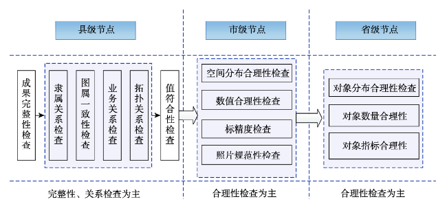
Fig. 2 Major verification points on provincial, city and county level图2 省、市、县级审核要点 |
Tab. 1 Investigation and evaluation results of national flash flood disasters表1 全国山洪灾害调查成果统计表 |
| 序号 | 成果名称 | 成果说明 |
|---|---|---|
| 1 | 空间信息数据库 | 52个图层,4576万个对象,全国2.5 m卫星遥感影像,56 TB |
| 2 | 属性数据库 | 58张属性表,54 855 495条数据记录;14类多媒体数据,总文件数1123万个,文档资料7类,总文件数33.5万个,23 TB |
| 3 | 省级工作底图 | 30个省,1:5万图幅26 409幅,8.6 TB |
| 4 | 县级工作底图 | 2138个县工作底图数据,13.5 TB |
| 5 | 全国山丘区小流域基础信息数据集 | 53万个小流域,16个图层,75项主要属性和水文特征、拓扑关系、标准化单位线,1.6 TB |
| 6 | 全国山洪灾害防治行政区划补充数据集(乡、村) | 乡镇界数据生产成果包括31个省共计2881个县的面状数据和约157万个自然村点数据 |
| 7 | 全国土地利用和植被类型数据集 | 30 m、2.5 m分辨率全国土地利用和植被类型数据,206 GB |
| 8 | 全国土壤类型和土壤质地类型数据集 | 全国土壤类型数据和土壤质地类型数据,261.68 MB |
Fig. 3 Spatial distribution of national flash flood disasters prevention areas (Data was not available in Taiwan Province)图3 全国山洪灾害防治区分布图 |
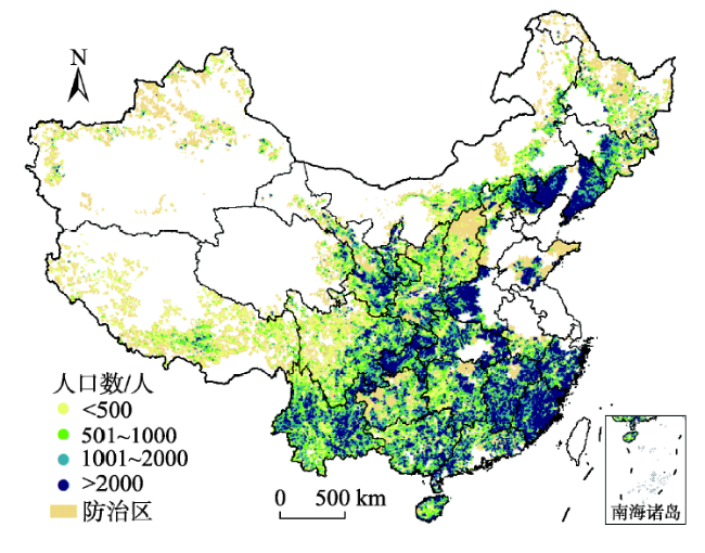
Fig. 4 Spatial distribution of human population in prevention areas of national flash flood disasters图4 全国山洪灾害防治区人口分区图 |
Fig. 5 Population in different hazard zones of prevention areas of national flash flood disasters图5 全国各级山洪灾害危险区人口 |
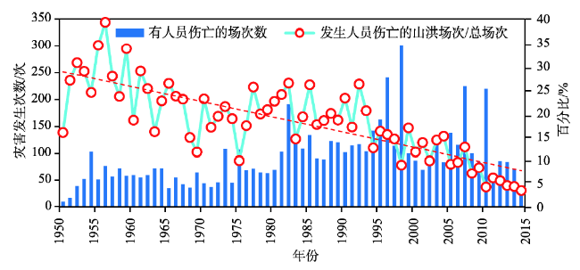
Fig. 6 The situations of historical flash flood disasters in China图6 全国调查历史山洪灾害发生情况 |
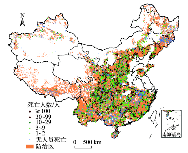
Fig. 7 Spatial distribution of historical flash flood disasters in China图7 全国历史山洪灾害分布图 |
Tab. 2 Frequency and death population of flash flood disasters since 1949表2 1949年以来全国山洪灾害发生及人员伤亡情况 |
| 发生时段 | 死亡人数/人 | 发生人员伤亡的灾害次数 | 无人员伤亡的山洪次数 | 年均山洪发生次数(无伤亡) |
|---|---|---|---|---|
| 1950-1959 | 7321 | 536 | 1346 | 135 |
| 1960-1969 | 6949 | 551 | 2307 | 231 |
| 1970-1979 | 8047 | 655 | 3121 | 312 |
| 1980-1989 | 10 745 | 1164 | 4570 | 457 |
| 1990-1999 | 10 505 | 1499 | 8984 | 898 |
| 2000-2009 | 10 138 | 1118 | 9330 | 933 |
| 2010-2016 | 5271 | 737 | 12 691 | 1813 |
Fig. 8 Spatial distribution of flash flood warning threshold in China图8 全国山洪灾害临界雨量分布图 |
The authors have declared that no competing interests exist.
| [1] |
|
| [2] |
[
|
| [3] |
[
|
| [4] |
[
|
| [5] |
[
|
| [7] |
[
|
| [7] |
[
|
| [8] |
[
|
| [9] |
[
|
| [10] |
[
|
| [11] |
[
|
| [12] |
[ Methods for delineation of codification of a large basin based on DEM and surveyed river network[J]. Advances in Water Science, 2006,17(2):259-264. ]
|
| [13] |
[
|
| [14] |
|
| [15] |
[
|
| [16] |
[
|
| [17] |
[
|
| [18] |
|
| [19] |
[
|
| [20] |
[
|
| [21] |
[
|
| [22] |
[
|
| [23] |
[
|
| [24] |
[
|
/
| 〈 |
|
〉 |


