
Journal of Geo-information Science >
Hazard Assessment of Mountain Torrent Disaster in Small Watersheds of the Hilly Areas of Hunan Province
Received date: 2017-07-07
Request revised date: 2017-09-24
Online published: 2017-12-25
Copyright
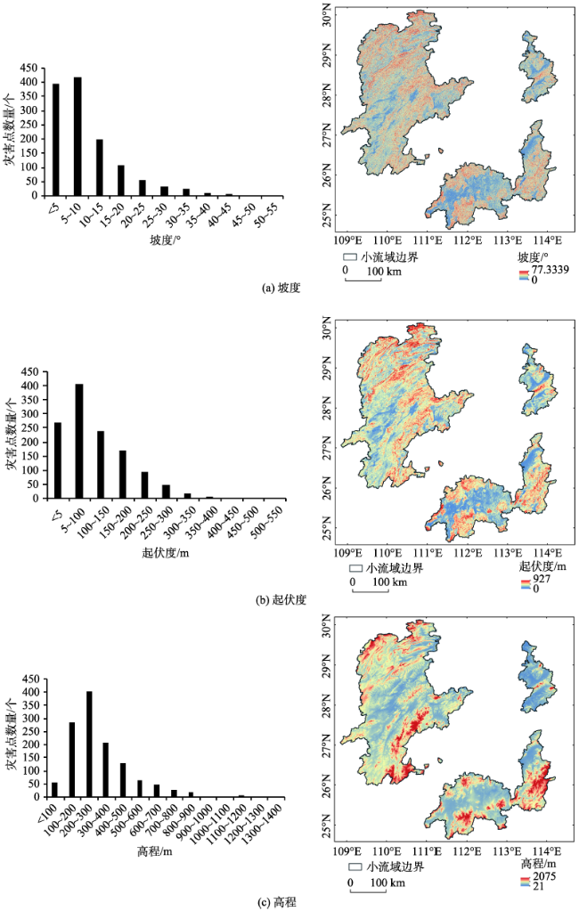
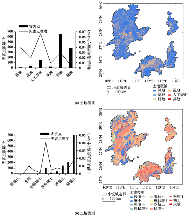
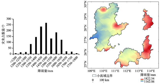
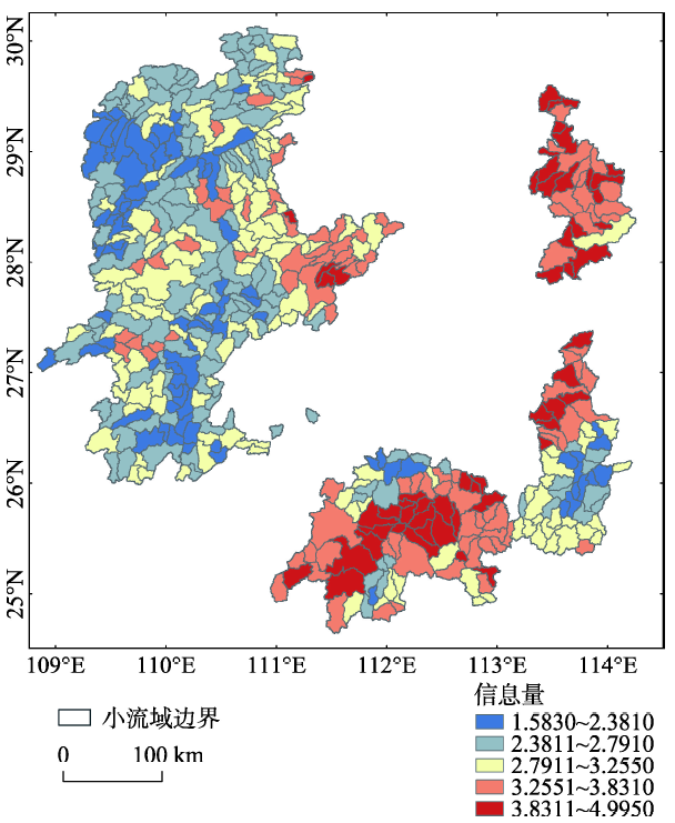
In this paper, we use the information volume model to study the hazard degree of mountain torrent disaster in hilly area of Hunan province. The greatest significance of the information volume model is that it can find the best combination of factors from various factors that affect the occurrence of mountain torrents. Hunan Province is one of the most serious mountain torrent disaster provinces in China. In order to study its hazard degree of the mountain torrent disaster, we divide Hunan Province into several small watersheds to evaluate the hazard of mountain torrent disaster using the data of historical flash flood disaster points spanning years from 1955 to 2015. Information volume model was established to calculate the information of the six factors: elevation, slope, relief, land cover, soil types and rainfall, respectively from the consideration of three aspects including the terrain, the underlying surface and the rainfall. The information volume of six factors were calculated, respectively. Based on the value of information volume of these factors, we obtained the combination of factors with the biggest influence of flash flood disasters. Through calculating the total value of information volume for all small watersheds in hilly areas of Hunan Province, we classified the information volume into five types associated with different dangerous levels. The results show that: the most significant contribution to the flash flood is the artificial surface of land cover type, with a information volume of 1.771, followed by the types with relief degree less than 30 m as well as the clay soil type (both at a value of 1.331). The mountainous torrent disaster for Hunan hilly area are likely occurred in areas with slope lower than 10°, elevation lower than 100 m, relief lower than 30 m, of which the land cover is artificial surface, the soil type is clay and annual mean rainfall is between 1584.3~1662.0 mm. Statistics of each level of dangerous areas show that the second-high and the third-high hazard types have the largest area in the mountain areas of Hunan, accounting for 26.59% and 26.63%of the total mountain areas, respectively. Area percentage of the fourth-high risk type is 20.89%, and that of the first and fifth-high hazard types is 13.89% and 11.99% respectively. In the hilly areas of Hunan province, cities with higher hazard levels are Yongzhou City, Chenzhou City, Zhuzhou City, Yueyang City, Loudi City and the eastern part of Changsha. In this study, 90% of the mountain torrents (1243 mountain torrents) were selected randomly from 1381 mountain torrents disaster spots in Hunan Province, and 10% of them were used to verify the hazard assessment results. The verification of confusion matrix demonstrated that the accuracy rate of this model is 75.36%, indicating a basically credible results of the spatial distribution of hazard degree estimated in this study. The mountain torrent disaster system established in this study still needs to be improved. The selection of factors and models, as well as the quantification of human activity factors should be considered in the further study.
YE Chaofan , ZHANG Yichi , XIONG Junnan , QIN Jianxin . Hazard Assessment of Mountain Torrent Disaster in Small Watersheds of the Hilly Areas of Hunan Province[J]. Journal of Geo-information Science, 2017 , 19(12) : 1593 -1603 . DOI: 10.3724/SP.J.1047.2017.01593
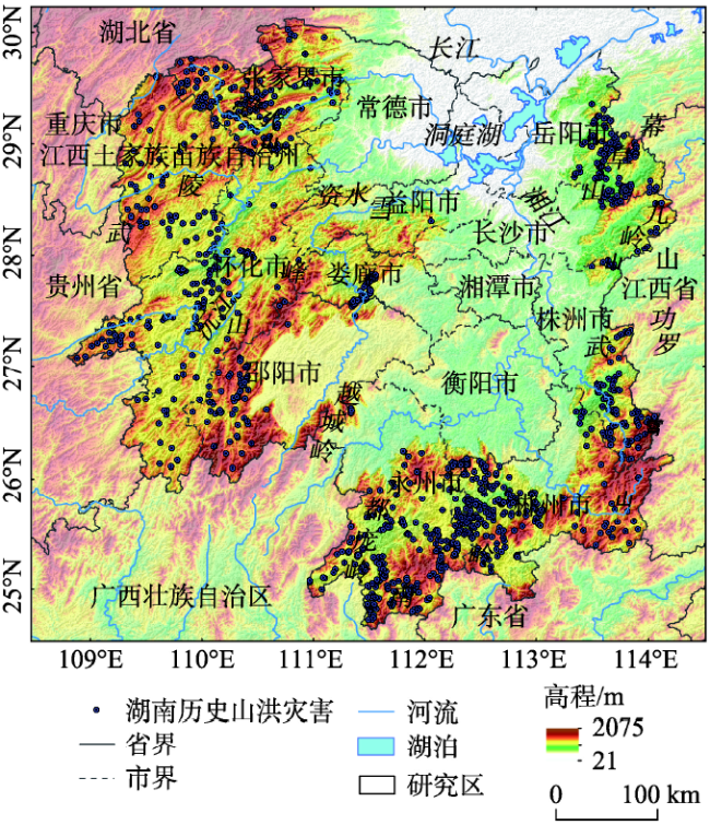
Fig. 1 Overview of the study area图1 研究区概况 |
Fig. 2 Spatial distribution of terrain dangerous index of mountain torrent disasters图2 山洪灾害地形危险性指标空间分异 |
Fig. 3 Spatial distribution of hazard index of underlying surfaces of mountain torrent disasters图3 山洪灾害下垫面危险性指标空间分异 |
Fig. 4 Spatial distribution of hazard index of the rainfall of mountain torrent disasters图4 山洪灾害降雨危险性指标空间分异 |
Tab. 1 Information volume of hazard assessment factors of mountain flood disasters表1 山洪灾害危险性评价因子信息量 |
| 评价因子 | 评价因子类别 | 信息量值 | 评价因子 | 评价因子类别 | 信息量值 |
|---|---|---|---|---|---|
| 高程 | <100 | 1.221 | 土壤类型 | 砂壤土 | -0.682 |
| 100~200 | 0.862 | 壤土 | -0.923 | ||
| 200~500 | 0.230 | 粉壤土 | 0.000 | ||
| 500~1000 | -1.026 | 砂粘壤土 | -0.823 | ||
| >1000 | -2.264 | 粘壤土 | 0.475 | ||
| 坡度 | <10 | 0.900 | 粉粘壤土 | -2.185 | |
| 10~20 | -0.406 | 砂粘土 | -0.471 | ||
| 20~30 | -1.195 | 壤粘土 | -0.365 | ||
| 30~50 | -1.410 | 粉粘土 | 0.000 | ||
| >50 | 0.000 | 粘土 | 1.331 | ||
| 起伏度 | <30 | 1.331 | 水域 | -0.100 | |
| 30~50 | 1.107 | 降雨 | 1162.1~1317.5 | -0.586 | |
| 50~200 | 0.126 | 1317.6~1390.0 | -0.383 | ||
| 200~500 | -1.068 | 1390.1~1452.2 | -0.213 | ||
| >500 | -1.327 | 1452.3~1516.9 | 0.334 | ||
| 土地覆被 | 林地 | -0.887 | 1517.0~1584.2 | 0.186 | |
| 草地 | -0.147 | 1584.3~1662.0 | 0.377 | ||
| 湿地 | 0.539 | 1662.1~1822.5 | -0.011 | ||
| 耕地 | 0.943 | ||||
| 人工表面 | 1.771 | ||||
| 其他 | 1.254 |
Fig. 5 Spatial distribution of the hazard levels of flash floods in small watersheds图5 小流域山洪灾害危险性等级空间分布 |
The authors have declared that no competing interests exist.
| [1] |
|
| [2] |
|
| [3] |
[
|
| [4] |
[
|
| [5] |
[
|
| [6] |
|
| [7] |
|
| [8] |
|
| [9] |
[
|
| [10] |
[
|
| [11] |
[
|
| [12] |
[
|
| [13] |
[
|
| [14] |
[
|
| [15] |
[
|
| [16] |
[
|
| [17] |
[
|
| [18] |
[
|
| [19] |
|
| [20] |
[
|
| [21] |
[
|
| [22] |
[
|
| [23] |
[
|
| [24] |
[
|
| [25] |
[
|
| [26] |
|
| [27] |
[
|
| [28] |
[
|
| [29] |
[
|
/
| 〈 |
|
〉 |