
Journal of Geo-information Science >
Numerical Modeling and Degree Division to Landslide Susceptibility in the Ground Surface of Huoxi Coal Mine Area
Received date: 2017-05-18
Request revised date: 2017-07-04
Online published: 2017-12-25
Copyright
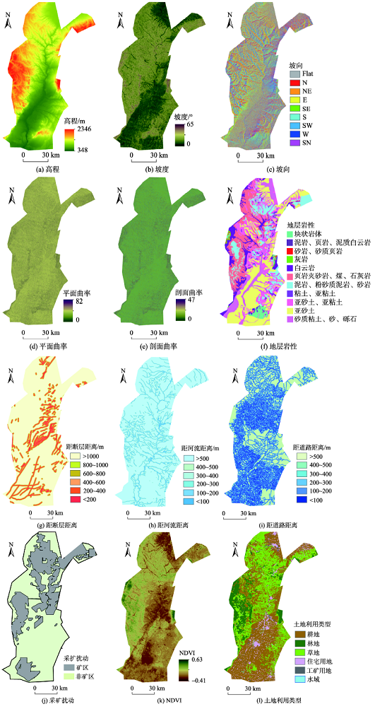
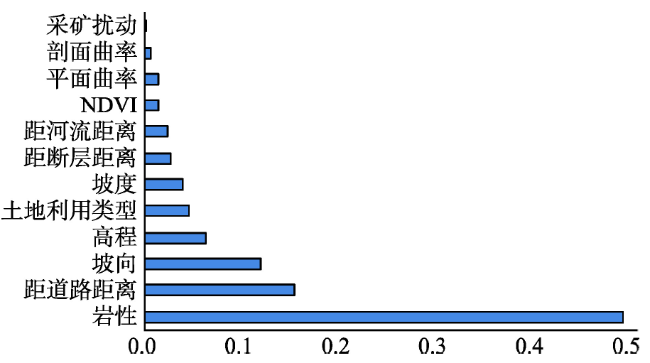
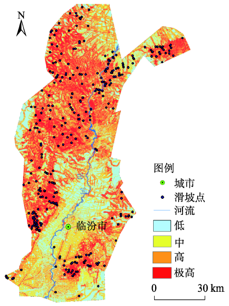
Taking Huoxi Coal Mine Area in Shanxi Province as the research area, we conducted numerical modeling and quantitative evaluation of landslide susceptibility using remote sensing and GIS technology. Based on the DEM with spatial resolution of 30 m × 30 m, five topographical parameters were derived: elevation, slope angle, slope aspect, plan curvature and profile curvature. Stratigraphic lithology was digitized based on the geological maps from Department of Geological Survey in 1:50 000 scale. Fault network, drainage network and road were digitized based on the geological maps and other thematic maps from Department of Land Resource in 1:50 000 scale. Then, buffer for faults, drainage, and road were done. Mining disturbance were digitized based on the planning maps of coal resources. If the point falls in the mine area, it is proved to be disturbed by the mining disturbance, otherwise is not affected. NDVI and land-use types interpreted and computed the Landsat TM images. Landslide data was collected by Bureau of Land and Resources and it is represented by the X, Y coordinates of its central point. Then, the correlation characteristics among evaluation factors and the spatial distribution of landslides were acquired by using remote sensing technology and GIS spatial analysis method. Repeated 5-fold cross validation method was adopted in this research and the landslide/non-landslide datasets were randomly split into a ratio of 80:20 for training and validating models. Based on the methods of the 5-fold cross-validation and the fitting accuracy to the constructed the landslide susceptibility assessment model-Radial Basis Function - Support Vector Machine (RBF-SVM), the precision of the models was quantitatively assessed. We calculated the importance of each evaluation factor in the RBF-SVM model. Meanwhile, we obtained landslide susceptibility map of Huoxi Coal Mine Area based on the RBF-SVM model. The landslide susceptibility of Huoxi Coal Mine Area was divided into four scales referencing the quantile law: low (0-0.02), medium (0.02-0.1), high (0.1-0.85) and very high (0.85-1) probability of landslide. The results show that: (1) the fitting accuracy was 87.22% in the modeling phase and 70.12% in the validation phase, respectively, for the RBF-SVM model; (2) it indicated that lithology, distance from road, slope aspect, elevation and land-use types have contribution to each model. Therefore, these five factors are most suitable conditioning factors for landslide susceptibility mapping in this area. Mining disturbance factors have little contribution to the model. The mining method in this area is underground mining and the mining depth is very deep affecting the stability of the slopes. (3) The number of landslides points in the very high region was 316, which account for 93.49% of the total number of landslides points and 50.99% of the total area. This study obtained the spatial distribution characteristics of the Huoxi Coalfield geological disasters and the quantitative evaluation of landslide susceptibility. It provides reference for the investigation about artificial slope in the research area monitoring the rational mining coal resources. It will also provide the reference for the related research in other similar coal region and management work.
SU Qiaomei , ZHAO Shangmin , GUO Jianli . Numerical Modeling and Degree Division to Landslide Susceptibility in the Ground Surface of Huoxi Coal Mine Area[J]. Journal of Geo-information Science, 2017 , 19(12) : 1613 -1622 . DOI: 10.3724/SP.J.1047.2017.01613
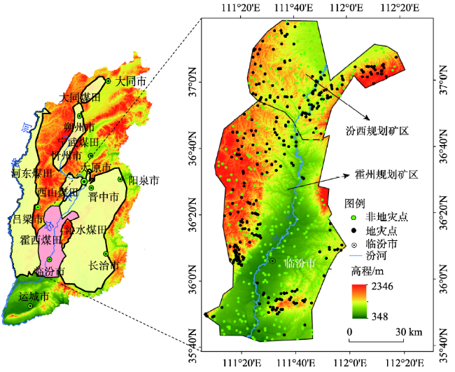
Fig. 1 Location and relief map of the study area图1 霍西煤矿区地理位置 |
Tab. 1 The list of parameters and their range of Huoxi Coal Mine Area表1 霍西煤矿区地质灾害评价基础数据表 |
| 基础因子 | 数据来源 | 数据分类 | 数据类型 |
|---|---|---|---|
| 高程/m | ASTER-GDEM(30 m) | 348~2346 | 连续值 |
| 平面曲率 | 0-82.03 | ||
| 剖面曲率 | 0-46.85 | ||
| 坡度/° | 0~64.5 | ||
| 坡向 | Flat;N;NE;E;SE;S;SW;W;NW | 分类值 | |
| 地层岩性 | 地质调查部门 (1:50 000) | 块状岩体;泥岩,页岩;砂岩,砂质页岩;灰岩;白云岩;页岩;煤,石灰岩; 粉砂质泥岩,砂岩;粘土,亚粘土;亚砂土,亚粘土;亚砂土;砂质粘土,砾石 | 分类值 |
| 距断层距离/m | <200,200~400,400~600,600~800,800~1000,>1000 | ||
| 距河流距离/m | 国土资源部门(1:50 000) | <100,100~200,200~300,300~400,400~500,>500 | 分类值 |
| 距道路距离/m | <100,100~200,200~300,300~400,400~500,>500 | ||
| 采矿扰动 | 开采区;非开采区 | ||
| 土地利用类型 | TM(30 m) | 耕地;林地;草地;住宅用地;工矿用地;水域 | 分类值 |
| NDVI | -0.414-0.631 | 连续值 |
Fig. 2 Factors of landslide conditions图2 滑坡基础条件因子 |
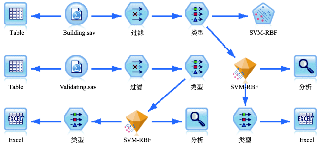
Fig. 3 Vector machine models supported by radial basis function in SPSS Modeler18 environment图3 径向基核函数支持向量机模型在SPSS Modeler18中构建的运行界面 |
Tab. 2 Vector machine parame ters of geological disaster susceptibility supported by radial basis function in Huoxi Coal Mine Area表2 霍西煤矿区滑坡敏感性径向基核函数支持向量机模型参数(RBF核函数) |
| 停止 标准 | 规则化 参数(C) | 回归准确度(Epsilon) | RBF伽马(RBF-γ) | 伽马(γ) | 度 |
|---|---|---|---|---|---|
| 1.0-3 | 0.8 | 0.1 | 0.95 | 1.0 | 3 |
Tab. 3 Precision of cross-validation of landslide susceptibility models in Huoxi Coal Mine Area表3 霍西煤矿区滑坡敏感性模型交叉检验精度/% |
| 阶段 | 平均值 | 标准差 |
|---|---|---|
| 建模 | 87.22 | 0.66 |
| 验证 | 70.12 | 4.07 |
Fig. 4 Relative importance of conditioning factors of the landslide susceptibility models in Huoxi Coal Mine Area图4 霍西煤矿区滑坡敏感性模型因子重要性 |
Tab. 4 Landslide susceptibility classification and distributions of landslide in Huoxi Coal Mine Area表4 霍西煤矿区滑坡敏感性分级及滑坡点分布情况 |
| 等级 | 预测值/% | 灾害点数量/个 | 数量百分比/% | 面积百分比/% |
|---|---|---|---|---|
| 低 | 0-2 | 1 | 0.30 | 20.38 |
| 中 | 2-10 | 21 | 6.21 | 28.64 |
| 高 | 10-85 | 67 | 19.82 | 25.71 |
| 极高 | 85-100 | 249 | 73.67 | 25.28 |
Fig. 5 Landslide susceptibility map图5 霍西煤矿区滑坡敏感性评价图 |
The authors have declared that no competing interests exist.
| [1] |
[
|
| [2] |
[
|
| [3] |
|
| [4] |
|
| [5] |
[
|
| [6] |
|
| [7] |
[
|
| [8] |
[
|
| [9] |
[
|
| [10] |
[
|
| [11] |
|
| [12] |
|
| [13] |
|
| [14] |
|
| [15] |
[
|
| [16] |
[
|
| [17] |
[ Wang X G. Zhai X J,
|
| [18] |
|
| [19] |
|
| [20] |
|
| [21] |
|
| [22] |
[
|
| [23] |
|
| [24] |
[
|
| [25] |
[
|
| [26] |
[
|
| [27] |
[
|
| [28] |
|
| [29] |
|
/
| 〈 |
|
〉 |